Bryan Norcross: East Coast storm still on table while Nigel slowly strengthens in central Atlantic
Computer forecasts show a non-tropical low-pressure system forming along the front when the two meet over the very warm Gulf Stream waters off the east coast of Florida about Friday.

FOX Weather is your Hurricane HQ, streaming free 24/7.
(FOX Weather)
Updated 8:30 a.m. ET Tuesday
The weak early-season cold front has stalled across southern Florida and will hang there for the rest of the week. An upper-air disturbance riding the southern branch of the jet stream will race across the country in the next few days.
Computer forecasts show a non-tropical low-pressure system forming along the front when the two meet over the very warm Gulf Stream waters off the east coast of Florida about Friday.
This process is common in the winter. It’s how nor’easters develop near the Southeast coast and track toward the north. What’s different here is that the ocean is warm enough, and the development is expected to be far enough south that the system could become tropical enough to get a name.
The process is not automatic, however. The system would have to linger long enough over the Gulf Stream to draw energy from the water, and it would have to shed its frontal origins and become an independent circulation.
The various computer forecast models disagree on the formation time, how long it will be over the water, and how strong it will get. If it did become tropical enough for the National Hurricane Center to write advisories on it, it would likely be a subtropical system – a hybrid between a tropical storm and a nor’easter.
An overview of the tropical Atlantic Ocean on Monday, September 19, 2023.
(FOX Weather)
If the system had sustained winds of at least 40 mph in the circulation, it would be named Subtropical Storm Ophelia. Or it could conceivably be Subtropical Storm Philippe, depending on what happens with the system on the other side of the Atlantic.
The current consensus is that the system will form offshore of the Florida or Southeast coast Thursday night or Friday and move north. Gusty winds and rain will spread well north of the system so that rain reaches the Mid-Atlantic on Saturday and continues into Sunday.
The question is … does the system wrap up quickly into a moderately strong subtropical storm before it runs ashore in the Carolinas or runs out of warm water east of Virginia? The time window is very short, so the National Hurricane Center is giving subtropical development a low chance of happening. But there’s still a good chance of a nasty squally storm affecting part or all of the coast from the Southeast to the Northeast, whether it meets the technical definition of a subtropical storm or not.
Stay aware of developments late this week.
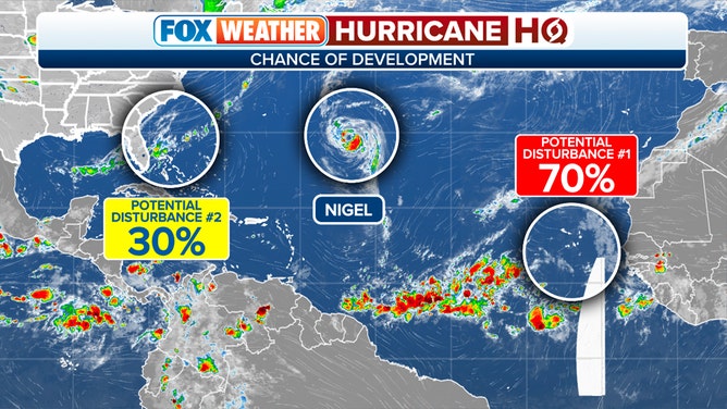
In the open ocean east of Bermuda, Hurricane Nigel has somewhat surprisingly not intensified as quickly as forecast. It’s still forecast to strengthen into a Category 2 hurricane as it passes Bermuda well offshore. It will turn into the North Atlantic and eventually weaken. The main effect will be to generate dangerous surf conditions on the U.S. East Coast later this week.
On the far side of the Atlantic, a disturbance is just about to move off the African coast. The National Hurricane Center is giving the system a high chance of developing into a tropical depression or tropical storm over the next several days.
The long-range computer forecasts diverge on the future track of the system, so we’ll keep an eye on it. It’s not going to move very fast, so we’ll be watching it for a while.