Developments in the tropics are slow but point toward more activity
There are some indications that the tropical Atlantic will slowly become more active next week as this first disturbance moistens the air and, if the long-range computer forecast models are correct, the flow of air off Africa increases.
The podcast Tracking the Tropics with Bryan Norcross is now available to stream.
(FOX Weather)
Updated at 9:30 a.m. EDT
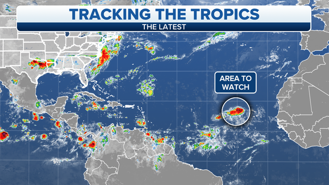
A large tropical disturbance is strolling west toward the central Atlantic. Some thunderstorms have developed near the nominal center, which is a sign the system has tapped into enough moisture to have a chance at eventual development. It’s plowing into an area of much drier air, however, so it remains to be seen if the thunderstorms persist.
Because of the very dry atmosphere in the path of the disturbance, the National Hurricane Center is giving it a low chance of development over the next 5 days, and mostly toward the end of the week when it’s farther west.
Development farther down the road is a possibility as well. The NHC doesn’t forecast beyond 5 days, and since the disturbance is moving so slowly, likely it won’t even have reached the vicinity of the Caribbean islands by the weekend. So, if it hangs together, we’ll be watching it for a week or more. Since the track downstream is somewhat dependent on whether it can organize, there is no reason to speculate where it might go in the long term.
HOW TO WATCH FOX WEATHER ON TV
A large tropical disturbance is strolling west toward the central Atlantic.
(FOX Weather)
The dry air over the tropics has been one factor limiting development this season, but another is the lack of a strong flow of air off Africa. This is why the systems aren’t moving very fast, but that African "jet" also contributes to getting tropical systems spinning. The fast air flow is normally along the top of the disturbances, which helps get them rotating counterclockwise.
There are some indications that the tropical Atlantic will slowly become more active next week as this first disturbance moistens the air and, if the long-range computer forecast models are correct, the flow of air off Africa increases.
The other macro factors we look at seem plenty conducive for development. In this type of environment, normally disturbances can overcome the dry air and weaker-than-normal African air flow, so some other less obvious factors appear to be going on. Still, the odds favor that systems will eventually develop just based on the calendar.
We’ll see. It’s been an interesting season so far. Let’s hope the slumber, whatever is causing it, continues.
FOX Weather Hurricane Specialist Bryan Norcross has a podcast, Tracking the Tropics with Bryan Norcross, available now on FOX News Audio. You can get it on your device by clicking here.