Complex disturbance appears more likely to organize, have wide-ranging impacts from Florida to the Carolinas
Originally it appeared that the disturbance would take time to evolve into a tropical-type system because it was wrapped up with a large upper-level low-pressure system sitting over the Bahamas.
The podcast Tracking the Tropics with Bryan Norcross is now available to stream.
(FOX Weather)
Disturbance #2 is evolving more quickly and in a different way than we previously thought. Originally it appeared that the disturbance would take time to evolve into a tropical-type system because it was wrapped up with a large upper-level low-pressure system sitting over the Bahamas.
Now, the computer forecast models indicate that the weather pattern over the system might become conducive for the system to organize and possibly strengthen as soon as tomorrow, giving the system more time over the warm tropical Atlantic and the Gulf Stream.
HOW TO WATCH FOX WEATHER ON TV
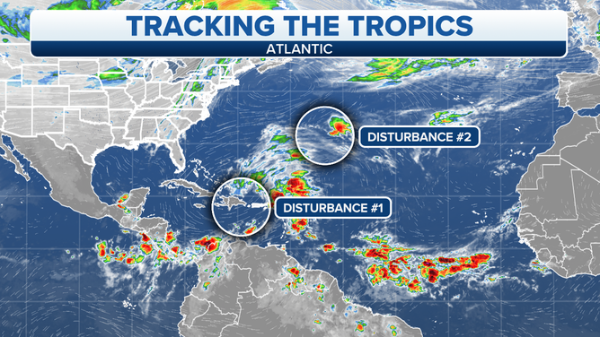
A map showing an overview of the tropical Atlantic Ocean.
(FOX Weather)
It is important to remember that predictions involving just-developing systems are always less certain and more subject to change than forecasts for organized storms. The exact formation point and nature of a new storm are unknowable. And since the forecast for the future strength and track of the storm is based on how it initially evolves, downstream predictions tend to dance around.
The system’s impact on Election Day weather will be limited to the effects from very breezy conditions at the coast, which will cause coastal flooding in some locations from Virginia to Florida as the ocean water is pushed into bays, harbors, and rivers exposed to the Atlantic. The wind will only partially be related to the developing disturbance. A strong high-pressure system far to the north will be equally responsible for the stretch of windy weather.
From Central Florida south to the Keys, increased rain chances will be more directly related to the wind coming off the ocean than to direct effects from the potential storm. Rain will become more likely late Tuesday.
As of now, the best evidence is that the developing system will arc from near Puerto Rico across or near the northern Bahamas and in the direction of Florida. Whether it will be a tropical storm or something else and the exact path is uncertain, but everybody on the Florida peninsula needs to stay informed about developments around midweek. The system has the potential to strengthen.
It is very certain, however, that the combination of the high-pressure system to the north and the developing low will generate strong winds along the entire coastline of the Southeast and Florida. The winds will pick up tomorrow and continue for a few days at least.
Since we don’t know how the storm is going to evolve in the short term, it is fruitless to speculate about the long-range forecast, though some computer forecast models show effects on the Gulf coast of Florida. The main point is, everybody needs to stay informed. When an organized system finally develops, if it does, we can have more confidence in longer-range forecasts.
In the central Atlantic, Disturbance #1 has a decent chance of becoming a tropical or subtropical storm, at least briefly. Winds have already been measured over 40 mph, so if thunderstorms flair up near the center of the circulation, the system will get a name. In any case, it would not be a threat to land.
Both of the disturbances have a decent chance of getting named. The next two names on the list are Nicole and Owen.
FOX Weather Hurricane Specialist Bryan Norcross has a podcast, Tracking the Tropics with Bryan Norcross, available now on FOX News Audio. You can get it on your device by clicking here.