Bryan Norcross: Caribbean Potential Tropical Cyclone 22 is still not organizing
There’s still a brief window of time between today and Sunday when a center could consolidate, and a tropical depression or Tropical Storm Vince could form. But it will gradually become less likely.

FOX Weather is your Hurricane HQ, streaming free 24/7.
(FOX Weather)
Updated Friday at 8:45 a.m. EST
The large area of disturbed weather we’ve been watching in the Caribbean is not getting better organized, and the upper-level winds are becoming more hostile. There’s still a brief window of time between today and Sunday when a center could consolidate, and a tropical depression or Tropical Storm Vince could form. But it will gradually become less likely.
The system extends from the Caribbean Sea across the north-central islands into the Atlantic and is officially named Potential Tropical Cyclone Twenty-Two. In other words, it has the potential to evolve into a tropical depression or tropical storm. As a result, Tropical Storm Watches have been issued by the governments in the affected islands.
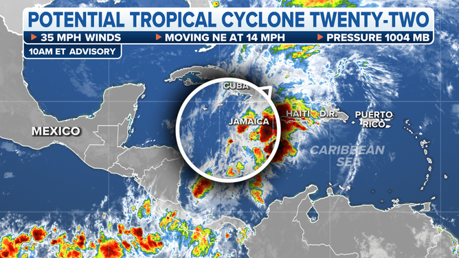
The current status of Potential Tropical Cyclone Twenty-Two.
(FOX Weather)
A Tropical Storm Watch means that winds of 40 mph or higher are possible. In a situation like this, the strongest winds will accompany the heaviest tropical downpours, which are not necessarily related to the nominal center of the stretched-out disturbance. This means that the cone is just a general guide to which direction the bad weather will move, not an indication of where the worst will be.
The main threat from this system is heavy rain – 5 to 10 inches of rain with local amounts up to 16 inches – that is forecast to fall over the mountains of Jamaica, eastern Cuba, Haiti and the Dominican Republic, causing flooding and possible mudslides. To the north, the southeastern Bahamas and the Turks and Caicos Islands will get heavy rain as well.
By Sunday, the front that moved off the East Coast of the U.S. will catch up to the system, and the circulation, if there is one, along with the moisture, will likely get absorbed. And that will be that as far as possible potential development.
The system will also produce a continuous flow of tropical moisture against the southern slopes of Puerto Rico for several days, so residents there should stay informed of the local alerts and forecasts, along with everybody in the affected islands.