Bryan Norcross: Caribbean system to bring heavy rain to the northern islands�
Everybody in Jamaica, eastern Cuba, Haiti, the Dominican Republic and the southeastern Bahamas should stay informed of the latest forecasts.

FOX Weather is your Hurricane HQ, streaming free 24/7.
(FOX Weather)
Updated Tuesday at 9 a.m. EST
An elongated area of disturbed weather is finally developing in the central and western Caribbean. It seems to be centered near the Honduras/Nicaragua border in a robust cluster of thunderstorms, but the system has yet to show any signs of organization. The upper-air environment over the area is still hostile to development, but that is forecast to change over the next couple of days.
A deep dip in the jet stream is associated with a separate strong non-tropical low-pressure system in the western Gulf of Mexico. That low, the upper-level dip and the connected fronts will push across the Gulf, bringing heavy rain from Louisiana to Florida today and tomorrow.
As the jet-stream dip progresses toward Florida, it will increasingly scoop the Caribbean system to the north. Simultaneously, the upper-level wind pattern will likely become more conducive for the disturbance to organize as it heads toward the northern islands. Whether it can consolidate into a tropical depression or not, abundant tropical moisture will stream north.
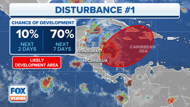
The outlook for a disturbance in the Caribbean Sea.
(FOX Weather)
The National Hurricane Center is giving the system a high chance of organizing into at least a tropical depression, but the main impact is likely to be from flooding rain.
Everybody in Jamaica, eastern Cuba, Haiti, the Dominican Republic and the southeastern Bahamas should stay informed of the latest forecasts.
The various computer forecasts show the disturbance streaming north toward the mountainous islands Thursday and Friday, but disagree on whether the broad system will be able to coalesce enough to be termed a tropical depression. They are less enthusiastic about the system getting organized today than they have been, but forecasts for undeveloped disturbances are always subject to change.
In any case, there is no indication of a strong storm forming out of this weather pattern, although we always watch for that possibility given the warm waters in the Caribbean. The main threat appears to be the potential for flash flooding from the tropical moisture interacting with the mountains.
On the current schedule, the Caribbean moisture would arrive in the north-central Caribbean on Thursday and last into the weekend before a cold front slowly pushes it east. Effects from the system on Puerto Rico and the surrounding islands could last into early next week.