Struggling Caribbean disturbance's future is uncertain but potentially threatening
The big question is, what’s going to happen next week? The computer forecast models are in agreement that the system will track across the Caribbean and slowly organize, but from the western Caribbean on, the tracks diverge.
The podcast Tracking the Tropics with Bryan Norcross is now available to stream.
(FOX Weather)
Updated at 11:30 a.m. ET
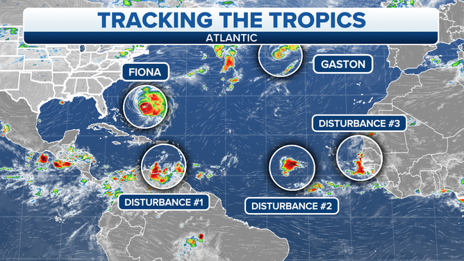
Tropical Disturbance #1 is a disorganized mass of squalls moving through the southeastern Caribbean Sea. The system is near the ABC Islands – Aruba, Bonaire, and Curaçao - and just offshore of the Venezuelan mainland. The consensus of the computer forecast models is that the disturbance will lift north away from the South American coast and track across the Caribbean Sea over the next few days.
For the next day or two, hostile upper-level winds related to powerful Hurricane Fiona are limiting the system’s ability to organize. As Fiona moves north and the disturbance continues west toward Mexico, the atmospheric environment should become more conducive for development with time. If the current forecasts are correct, the disturbance will organize into a tropical depression in the next couple of days and become a named tropical storm over the weekend – plus or minus.
Several areas are being monitored for tropical development in the Atlantic Basin.
(FOX Weather)
The next name on the list is Hermine, and the one after it is Ian. Tropical Disturbance #3, which is just moving off Africa, might develop before Tropical Disturbance #1 in the Caribbean. Both systems appear likely to develop into named storms. The first developer becomes Hermine, and the second will be Ian.
HOW TO WATCH FOX WEATHER ON TV
The big question is, what’s going to happen next week? The computer forecast models are in agreement that the system will track across the Caribbean and slowly organize, but from the western Caribbean on, the tracks diverge.
The differences in the various possible forecast tracks north of the Caribbean are related to exactly where the system is located when a dip in the jet stream arrives to scoop it north and how strong the system is at that time. If the disturbance dawdles, the scoop might miss it, and that opens the door to many possibilities around the Gulf coast, including the western Gulf. If the scoop catches it, the system – likely a tropical storm or hurricane – would probably be deflected farther east, and there’s room for middle ground as well.
When we look at our Forecast Track Uncertainty product below, it’s misleading today. It shows most of the yellow tracks we look at to gauge the uncertainty in the forecast to the left of the center "Consensus" line. There is a batch of yellow lines missing from the European model that would fill in the gap on the right. So our distribution of possible tracks continues to range from the Gulf to Florida to the Bahamas.
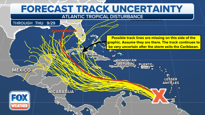
Forecast uncertainty track model.
(FOX Weather)
The orange Consensus line is an average of the best-performing computer forecast models over time. At the end of the season, it is normally the most accurate model or very close to it. But all computer forecast models, and forecasts in general, are relatively poor for just-developing or disorganized systems. So we would expect the details of the forecast for this disorganized disturbance to have higher than normal errors and be likely to change as the system develops.
If the forecasts are reasonably correct, the system will be moving into the western Gulf about Sunday and will have strengthened into at least a tropical storm. Exactly where the center of the storm will be located is an open question. And that will make a big difference in which trajectory the system will take when the jet stream comes along to scoop it north.
For Monday, the forecasts show extremely conducive conditions in the western Gulf for the system to strengthen. There’s no obvious reason why the system wouldn’t become a hurricane if it pulls away from the Venezuelan coast with enough organization to develop a defined circulation.
Over the weekend, we should have a much better idea of what’s going to happen next week – at least in broad terms. At that point, the disturbance is forecast to be organized enough that the computer forecast models should provide guidance that is not spread across the Gulf and all the way to the Bahamas.
It’s important that everybody along the Gulf Coast, in Florida and in the Bahamas stay informed day by day as the forecasts get refined. The soonest it could affect the U.S. appears to be on Tuesday.
Hurricane Fiona will make its closest approach to Bermuda tonight. The current forecasts keep the center of the storm about 120 miles offshore, but Fiona is a large, powerful hurricane. The Bermuda Meteorological Service has upgraded its alert to a Hurricane Warning. The island won’t get the worst of the storm, but a period of wind gusts over 100 mph with heavy rain is still forecast.
From Bermuda, Fiona will move on toward Atlantic Canada. The hurricane will merge with a strong northern system to create a giant North Atlantic storm with hurricane-strength winds and torrential rain. This has the potential to be one of the worst storms in Atlantic Canada on record.
Tropical Storm Gaston is now forecast to loop near the Azores in the northeastern Atlantic. Tropical Storm Warnings are up for those islands. The system is likely to die out in the next few days.
Tropical Disturbance #2 is of no consequence. It only has a slight chance of developing and should die out in the central Atlantic.
Tropical Disturbance #3 is just exiting the African coast. It is forecast to quickly turn north, and there’s a good chance it will quickly become at least a tropical depression. This is the system that’s in a race with the Caribbean disturbance to see who gets named first.
Nothing else appears imminent, all this is clearly enough.
FOX Weather Hurricane Specialist Bryan Norcross has a podcast, Tracking the Tropics with Bryan Norcross, available now on FOX News Audio. You can get it on your device by clicking here.