Bryan Norcross: Caribbean disturbance Invest 97L now less likely to develop before it reaches Central America
There are no signs of organization yet, and the consensus of the various computer forecasts is that it’s not going to have time to develop into an organized system before it gets there.

FOX Weather is your Hurricane HQ, streaming free 24/7.
(FOX Weather)
Updated Thursday at 9:15 a.m. EDT
The large tropical disturbance in the Caribbean – officially tagged Invest 97L – is advancing toward Central America. There are no signs of organization yet, and the consensus of the various computer forecasts is that it’s not going to have time to develop into an organized system before it gets there.
The National Hurricane Center is now giving the disturbance a low chance of developing even into a tropical depression.
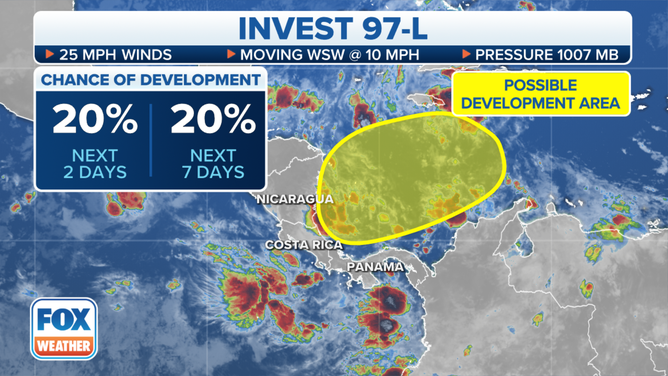
(The large tropical disturbance in the Caribbean – officially tagged Invest 97L – is advancing toward Central America. / FOX Weather)
In any case, a large slug of tropical moisture will impact Costa Rica, Nicaragua, Honduras, Guatemala, Belize and part of Yucatán Mexico beginning tomorrow. Some of these countries have been impacted Pacific Tropical Storm Pilar over the last few days. Flash flooding will be a significant threat with the additional moisture from the disturbance.
The water in western Caribbean is at record-high temperatures – close to the warmest it has ever been any time of year, so they are lucky in Central America that the disturbance has not been able to get organized so it could use that extra heat to intensify.
As we have learned a number of times this season, the science behind forecasting whether a system is going to develop and strengthen still needs more work. The factors appear subtle and involve more than just analyzing the upper-level winds and ocean temperatures, although they are a part of the equation. Scientists around the world are working on this problem, but we’re not there on a consistent basis yet.
The jet stream is screaming across the Gulf of Mexico, tropical Atlantic and most of the Caribbean. Combined with the dry air that was brought south by the series of cold fronts that have passed through Florida, the weather pattern would prohibit tropical systems from developing even if other factors were conducive. There is a small pocket in the extreme southern Caribbean Sea that is outside of the hostile zone, so we continue to keep an eye on that, although that area is shrinking as well.
In November, we occasionally have surprises, but no opportunities are evident in the long-range computer forecasts. There’s a good chance that the hurricane season for the U.S. and surrounding areas is over. Probably.