Bryan Norcross: Calvin to impact the Big Island of Hawaii tonight while dust and Don are the Atlantic story
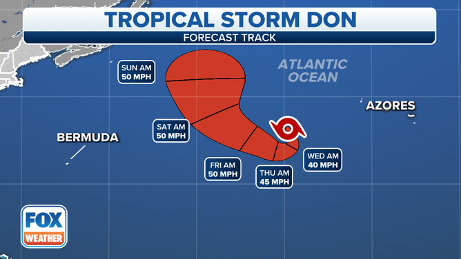
In the Atlantic, Don has regenerated enough to now be called a tropical storm. Don is making a big clockwise donut in the central Atlantic as a high-pressure cell oozes over top of it, changing the steering flow as it moves east.

FOX Weather is your Hurricane HQ, streaming free 24/7.
(FOX Weather)
Updated Tuesday 9 a.m. EDT
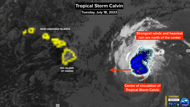
Tropical Storm Calvin is on track to impact the western Hawaiian Islands beginning tonight. Calvin's center of circulation may well pass just south of the Big Island, but the strongest winds and heaviest rain are in the northern part of the circulation. The tall mountains – the famous volcanoes that make up the island of Hawaii – will enhance the effects of the wind and rain.
Residents on the Big Island should be ready for strong gusty winds up to 50 or 60 mph and the potential for flash flooding from intense tropical downpours. Higher-than-normal surf will pound the coastline in the areas where the wind is onshore.
A look at Tropical Storm Calvin in the Pacific Ocean.
Even though Calvin's sustained winds are weakening, aloft the winds are stronger. Those more intense gusts will impact communities at higher elevations. Power outages are possible. In addition, the National Weather Service is predicting 4 to 8 inches of rain over the affected parts of the Big Island, with some areas receiving 10 inches or more.

Forecast cone for Tropical Storm Calvin.
(FOX Weather)
Because the exact angle that Calvin's most intense rain bands interact with the mountains is not knowable, exactly where the wind and rain will be enhanced by the peaks, valleys, and passes can't be known either. But residents in flood-prone areas should stay on high alert.
Calvin will pass south of the rest of the main Hawaiian Islands tomorrow. Only peripheral effects are expected from Maui through the rest of the island chain.
In the Atlantic, Don has regenerated enough to now be called a tropical storm. Don is making a big clockwise donut in the central Atlantic as a high-pressure cell oozes over top of it, changing the steering flow as it moves east. The blocking effects of the high should end by the weekend, so Don can head into the oblivion of the North Atlantic by early next week.
The forecast cone for Don in the central Atlantic.
(FOX Weather)
Don isn't expected to have any significant effect on land.
In the tropical Atlantic, robust disturbances are moving off the African coast, but Saharan dust and dry air will not allow them to develop as they track west through the storm belt. That's where we'll pay close attention to developments later in the season.
It's a good thing the dust is in place because the hostile upper winds have let up for now across that main development zone. No threats are expected through next weekend.