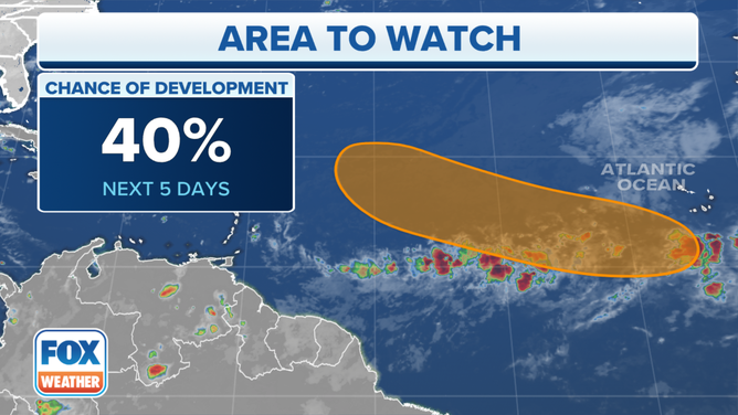
Atlantic disturbance showing some signs of organization
The environment ahead of the disturbance appears reasonably conducive for further development over the next few days as it progresses in the general direction of the waters north of Puerto Rico
The podcast Tracking the Tropics with Bryan Norcross is now available to stream
(FOX Weather)
Updated at 9:30 a.m. Eastern: The robust tropical disturbance that moved off the coast of Africa yesterday is showing some signs of organization. The thunderstorms are becoming somewhat more concentrated, and there is a bit of curvature to some of the cloud elements.
HOW TO WATCH FOX WEATHER ON TV
The environment ahead of the disturbance appears reasonably conducive for further development over the next few days as it progresses in the general direction of the waters north of Puerto Rico.
As it approaches the vicinity of the islands in about a week, however, the ocean water will get cooler, and the atmospheric pattern is forecast to become more hostile. Though, there is disagreement among the most reliable computer forecast models about how the pattern will evolve.
(FOX Weather)
The National Hurricane Center is giving the system a decent chance of becoming at least a tropical depression this week over the tropical Atlantic.
Early indications are that the system will have a northerly component to its track, so it misses the Caribbean islands. But it won’t be in that vicinity until the weekend at the earliest. And we always have to remember that forecasts for disorganized systems are subject to larger errors than well-developed circulations, so the predictions are subject to change.
Otherwise, nothing seems to be in the offing across the Atlantic, the Caribbean Sea, or the Gulf of Mexico.
FOX Weather Hurricane Specialist Bryan Norcross has a podcast, Tracking the Tropics with Bryan Norcross, available now on FOX News Audio. You can get it on your device by clicking here.