Bryan Norcross: As Hurricane Lee gains strength in Atlantic what about future impacts on East Coast?
Dangerously high surf and scouring swells are likely along the entire U.S. East Coast. The energy from Lee is forecast to reach the Southeast coast Tuesday and Wednesday and move north Thursday and Friday.

FOX Weather is your Hurricane HQ, streaming free 24/7.
(FOX Weather / FOX Weather)
UPDATED Thursday at 9 a.m. ET
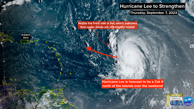
Hurricane Lee is on track and slowly strengthening. The ocean and atmosphere ahead appear extremely conducive for significant intensification, so the National Hurricane Center and the computer forecasts show a super-intense hurricane as it tracks well north of Puerto Rico and the surrounding islands over the weekend.
The NHC's forecast is for Lee to become a strong Category 4 as its forward speed slows in the waters north of the islands. Yes, it could be a Category 5 at some point. The top winds are likely to fluctuate up and down but remain very strong well into next week.
There is high confidence that Lee's core, where the strongest winds are, will miss the northeast Caribbean islands including Puerto Rico. The computer forecast models are in unusually good agreement on that point. Some fringe effects are expected in the islands, though nothing substantial beyond dangerous surf and large swells offshore.
Hurricane Lee in the Atlantic.
(NOAA)
About Wednesday of next week, Lee should start a pronounced turn to the north. Most of the computer forecast models predict that to happen, but there are some open questions.
A dip in the jet stream is forecast to scoop up the storm while it is still east of the Bahamas. How strong that scoop will be and exactly where Lee will be located when it gets scooped will affect the future track. Confidence is high that Hurricane Lee will not directly impact Florida, Georgia, and South Carolina, though dangerous surf powered by Lee's strong winds will be an issue along the coast.
The current indications are that Lee will turn soon enough that the Bahamas will only get high surf and fringe effects, but that's not 100%. We'll know more over the weekend.
At the end of next week, Hurricane Lee is forecast to be somewhere offshore of the Carolinas. If it has migrated far enough north, there's a good chance it will get scooped out to sea. If it dawdles, however, the future track becomes a bit fuzzy, and the storm might track closer to the Mid-Atlantic or Northeast coast.
In any case, dangerously high surf and scouring swells are likely along the entire U.S. East Coast. The energy from Lee is forecast to reach the Southeast coast Tuesday and Wednesday and move north Thursday and Friday. On the current schedule, the ocean water will be elevated and extremely dangerous along the Mid-Atlantic and Northeast beaches late next week and into the weekend.
NOAA satellite imagery of Hurricane Lee.
We're talking about effects more than a week away, so the outcome is still a bit uncertain. But everyone from North Carolina to Maine should plan to stay aware of the latest forecasts during the second half of next week.
Strong hurricanes can have significant impacts well outside the cone, so it's critical that everybody pay attention to the various warnings that will be issued as Hurricane Lee tracks north next week.
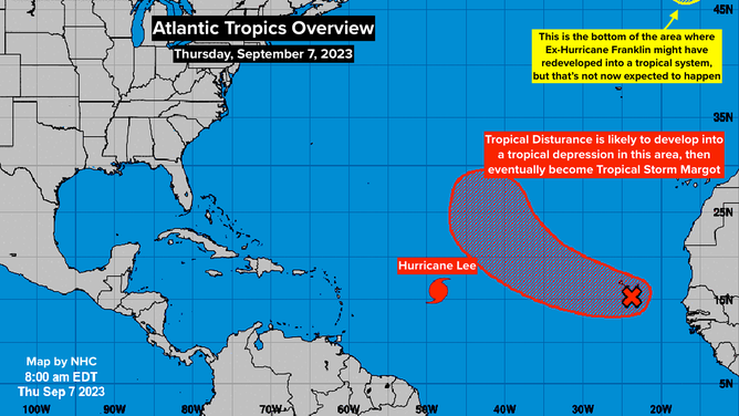
In the east Atlantic, the Tropical Disturbance officially called Invest #96L has a good chance of eventually becoming Tropical Storm Margot. After it's past the Cabo Verde Islands, it's expected to organize into a tropical storm and possibly a hurricane. The long-range forecasts call for it to die out in the middle of the Atlantic.
The disturbance behind it is still over Africa. We'll see if it gets any traction when it crosses into the Atlantic. Currently, the upper winds ahead appear somewhat hostile.