Arctic blast to bring rare lowland snow, bitter cold temps to Pacific Northwest
An intense and deep arctic air mass developing in western Canada is forecast to sweep down into the northwestern U.S. starting on Christmas Day, bringing cold temperatures to a level rarely seen in this part of the nation.
Arctic blast to deliver freezing temperatures to Northwest US
Cold air from an arctic blast will make its way to a good portion of the northwestern United States early next week.
SEATTLE -- While some of the nation will be basking in what could pass for a wintertime heatwave, much of the Pacific Northwest and the northern Rockies are about to go into the icebox -- and stay there for several days.
An intense and deep arctic air mass developing in western Canada is forecast to sweep down into the northwestern U.S. starting on Christmas Day, with cold air continuing to pour into the region through next week, bringing cold temperatures to a level rarely seen in this part of the nation.
In Western Washington, already Winter Storm Watches are in effect for the northwestern corner of the state starting Friday evening and lasting into Sunday for 1-8 inches of snow and 40 mph winds as the arctic air begins to flow into the region from the Fraser River Valley.
Snow levels are expected to drop to sea level across the rest of Western Washington as early as Saturday afternoon or by Saturday night. Light snow is expected at times even in the metro areas Saturday night and Sunday and perhaps lingering into Monday, with 1-3 inches likely across the region by Sunday with a couple more inches by Monday.
Seattle generally has about a 7% chance of snow on Christmas Day in any given year. The last time was in 2017.
As arctic air spills south into Oregon, snow chances increase there as well. The National Weather Service is giving a 75-85% chance of at least 1 inch of snow across the Willamette Valley and northwestern Oregon Sunday, with only slightly less probability for additional snowfall on Monday. There is about a 20-30% chance of the inland areas away from the coast receiving 4 inches of snow or more.
Snowfall in the Seattle and Portland metro areas is uncommon but usually occurs a few times a winter -- both cities average about 6 inches of snowfall a year. Snow is expected in Eastern Washington and Oregon too, but snow is common in the winter on that side of the mountains.
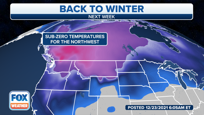
But some of the predicted low temperatures later next week as the arctic air settles in could be some of the coldest seen in several years -- if not decades -- across the region, and last for several days.
High temperatures next week will likely be stuck in the 20s around Seattle and Portland with lows in the teens to even single digits in the outlying areas in Western Washington, especially communities near the Canadian border where arctic air flows from the Fraser River Valley. A few of the more extreme forecast models solutions show low temperatures reaching single digits in Seattle, which would be the first time that happened since 1989.
In Eastern Washington, low temperatures are expected to drop below zero, with areas near the Canadian border dropping to as low as -10 to -15 degrees.
(FOX Weather)
"We are expected to see many days with temperatures this cold," forecasters with the National Weather Service office Spokane wrote. "Temperatures like this for this long haven't been seen since 2009."
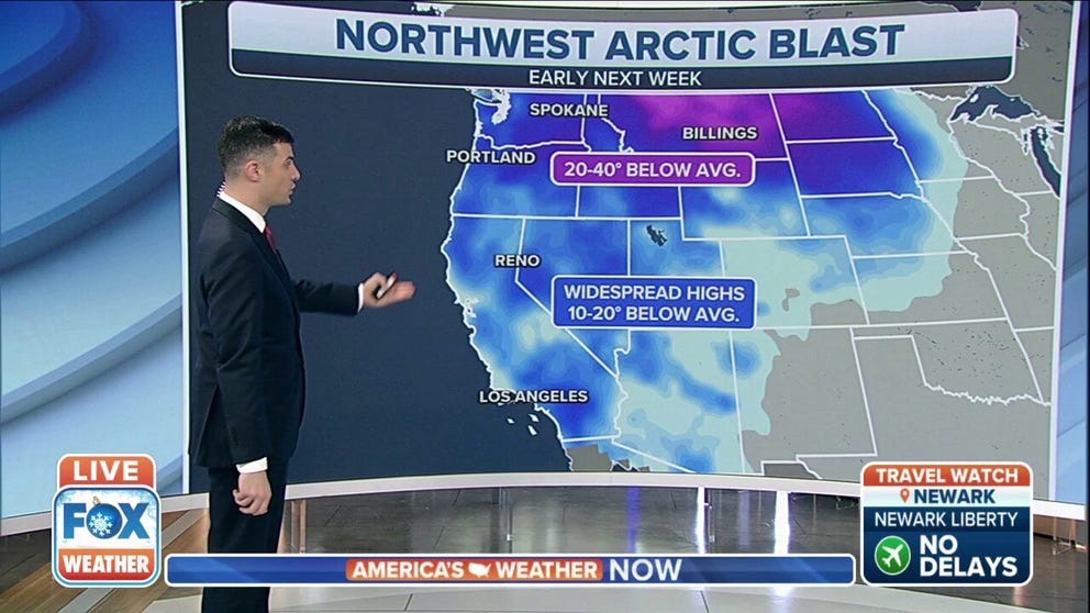
But it won't just be the Pacific Northwest caught in the arctic blast. Temperatures 25-35 degrees below average are forecast to spread across much of Montana, Idaho, and northern Nevada by the middle of next week with temperatures around 10-15 degrees below average are expected in California, southern Nevada and Utah.
And any relief will require a long wait, as arctic air is expected to remain entrenched across western Canada and the Pacific Northwest past New Year's Day and into the following week.