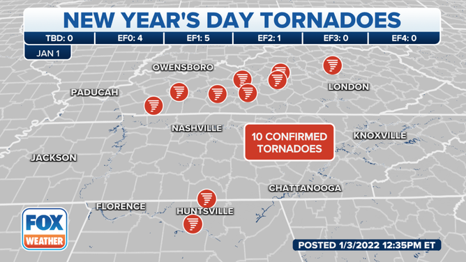
7 tornadoes confirmed in Kentucky after severe weather in the mid-South on Saturday
National Weather Service meteorologists so far confirmed 10 tornadoes across the South on Saturday.

98.7 WHOP FM in Hopkinsville, Kentucky, reports significant damage from a possible tornado on the east side of the town near East Ninth and Campbell streets. No immediate reports of significant injuries.
(98.7 WHOP FM)
The first storm system of 2022 produced severe storms and flooding rains from Arkansas to the mid-Atlantic, ahead of a major cool down that will remind residents in the eastern half of the nation that the country is in the heart of winter.
Some of the areas that were hardest hit included northern Alabama, Tennessee and southern Kentucky where wind damage and flooding were reported. At least seven tornadoes have been confirmed in Kentucky as of Sunday. Survey crews will continue working on Monday to determine if damage across Logan and Green Counties was also from tornadoes.
The National Weather Service in Paducah, Kentucky, said a survey team has found damage consistent with an EF-2 tornado in Hopkinsville. While the survey will continue, preliminary information showed winds were near 115 mph with a part of about 125 yards.

Tornado damage in Downtown Hopkinsville, Kentucky
Saturday, a tornado tore through Downtown Hopkinsville, Kentucky.
The NWS also said survey teams on the south side of Bowling Green near Cave Mill Road have found damage consistent with at least an EF-0, with maximum winds of 85 mph and straight-line wind damage of 75 mph. The NWS also confirmed an EF-0 tornado in Hart County which ripped the roofs off a couple of outbuildings.
Another tornado was confirmed in Madison County, Kentucky. The NWS said damage consistent with an EF-1 tornado was found and winds so far are estimated to have been 90 mph. Barron County near Glasgow, Marion County, Madison County, and Taylor County also reported damage from EF-0 tornadoes.
The Storm Prediction Center received more than 50 reports of wind damage across five states on Saturday night.
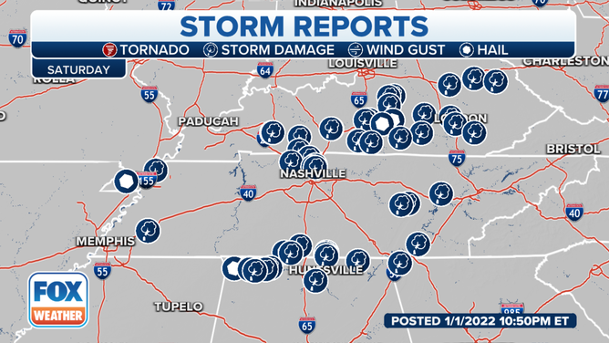
The Storm Prediction Center received more than 50 reports of severe weather on Saturday.
(FOX Weather)
THREAT FOR SEVERE STORMS IN SOUTH SHIFTS EASTWARD ON SUNDAY
Kentucky hit hard again
The Governor of Kentucky issued a state of emergency after some parts of the state saw nearly half a foot of rain and dealt with tornado-warned storms.
"Unfortunately, we continue to experience severe weather in the commonwealth as we move into the new year, with impacts across our south central counties experiencing heavy rainfall, flash flooding, tornado strikes and continuous squall lines," said Michael Dossett, director of Kentucky Emergency Management.
Significant damage was reported around the Bowling Green area, where Western Kentucky University captured a supercell thunderstorm on camera.
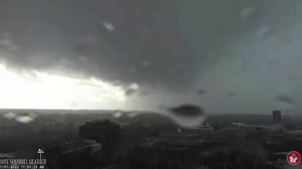
Supercell storm caught on camera from Western Kentucky University
Tornado sirens sound over Bowling Green, Kentucky
Several homes and businesses were damaged, but luckily there were no reports of any fatalities.
In addition to the damaging winds, the severe storms produced torrential rainfall leading to flash flooding.
Casey County, Kentucky, reported over 5 inches of rain.
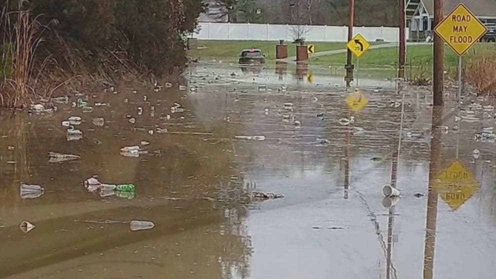
Kentucky Flash Flooding
Parts of southern and central Kentucky saw upwards of a half a foot of rain on Saturday, which led to flash flooding.
National Weather Service meteorologists have been touring damaged regions Sunday, and that is expected to continue into Monday to determine what type of mode of severe weather was responsible for the damage in the Bluegrass State.
The storm system came less than a month after a tornado outbreak in December damaged thousands of homes, displacing more than 1,000 Kentuckians.
(FOX Weather)
Tornados moved through Alabama
Several counties in northern Alabama were put under tornado warnings on Saturday evening as meteorologists detected rotation in storm cells.
Several damage reports were centered around the state’s largest city of Huntsville where an EF-0 tornado touched down near New Market.

Possible tornado damage in New Market, Alabama
Emergency managers reported that a tornado destroyed a mobile home and injured the resident on Saturday in New Market, Alabama just north of Huntsville.
The Madison County Sheriff reported roof damage to several homes and businesses after the severe storms rolled through.
NWS meteorologists confirmed an EF-1 tornado in Limestone County as well. The storm snapped trees and tore off sections of roof.
Confirmed tornado in Georgia
Survey crews confirmed an EF-1 tornado near Villa Rica, Georgia uprooted trees and tore siding from homes.