Live updates: Severe weather hammers the Heartland with dangerous tornadoes, huge hail
Live updates: Severe weather hammers the Heartland with dangerous tornadoes, huge hail
Download the AppLIVE Severe Weather HQ coverage continues
View postCoverage for this event has ended.
The severe weather threat continues into Friday. We have moved our live coverage to a new thread to keep you informed ahead of the storms.
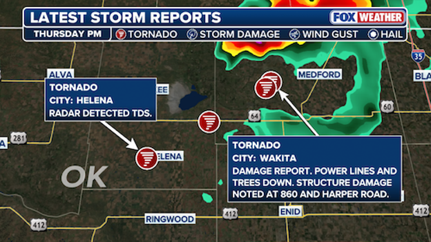
Damage reported as storms pass through northwestern Oklahoma.
Damage caused by a confirmed tornado is being reported in Wikita, Oklahoma, according to the National Weather Service.
Power lines and trees have reportedly come down in the northwestern portion of the state, and there's a preliminary report of structural damage.
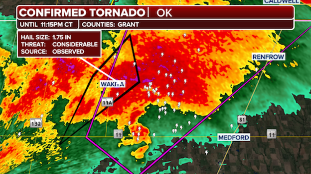
A confirmed tornado is on the ground near Wakita, Oklahoma.
A particularly dangerous tornado is on the ground near Wakita, Oklahoma.
The confirmed "large and extremely dangerous tornado" is moving northeast at 30 mph, according to the National Weather Service.
People in the area should take shelter immediately. Flying debris can be deadly to those caught in the storm.
A potentially dangerous tornado is heading north and the Tornado Warning has been extended into Grant County, Oklahoma.
The National Weather Service said deviant motion is possible with this tornado, meaning it could deviate from its parent supercell.
Residents in the area should take shelter immediately.
A "Particularly dangerous situation" unfolding as a confirmed tornado swirls near southwestern Grant County, Oklahoma.
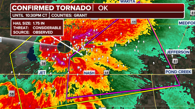
Confirmed tornado in Grant County, OK
"A confirmed large and extremely dangerous tornado was located 4 miles west-northwest of Nash, Oklahoma, moving northeast at 30 mph," a National Weather Service warning wrote.
A tornado warning remains in effect in the area until 10:30 p.m. CST.
Stick with FOX Weather as Meteorologist Ari Sarsalari tracks severe weather in the Southern Plains.
A radar-confirmed tornado has been observed in Alfalfa County in Northwestern, Oklahoma, as a particularly dangerous situation is unfolding.
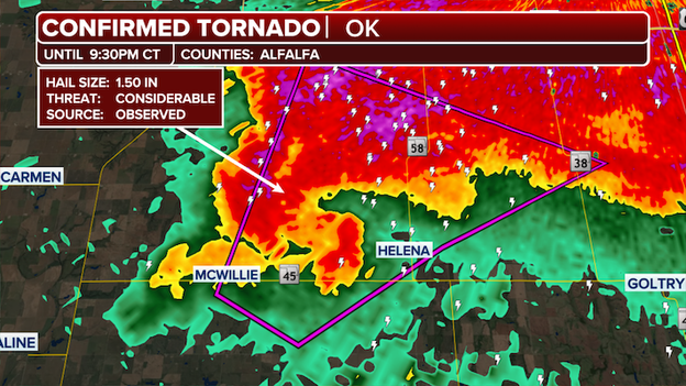
Confirmed tornado near Helena, Oklahoma
The "confirmed large and extremely dangerous tornado" was located near Helena, moving northeast at 20 mph.
The storm is approaching Jet and Great Salt Plains Lake State Park in Oklahoma.
The National Weather Service warning said, "You are in a life-threatening situation. Flying debris may be deadly to those caught without shelter. Mobile homes will be destroyed. Considerable damage to homes, businesses, and vehicles is likely and complete destruction is possible"
A Tornado Warning has been issued for Collingsworth County, Texas.
The National Weather Service previously reported that a spotter had observed the tornado near Quail, Texas.
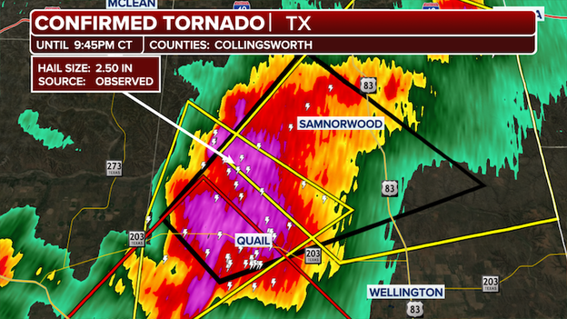
Confirmed tornado in Collingsworth County, Texas
Residents in the warned area should seek shelter immediately.
Over the past three hours, a corridor across the Southern Plains of Texas and Oklahoma has been pounded by intense hail.
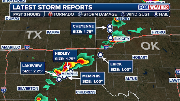
Latest storm reports
Storm reports indicate a wide range of hail sizes in the hardest-hit areas.
In Lakeview, Texas, hailstones measuring up to 2.25 inches in diameter were reported, underscoring the severity of the storms moving through the region.
A Tornado Warning has been issued for parts of Major County in northwestern Oklahoma until 8:45 p.m. CST.
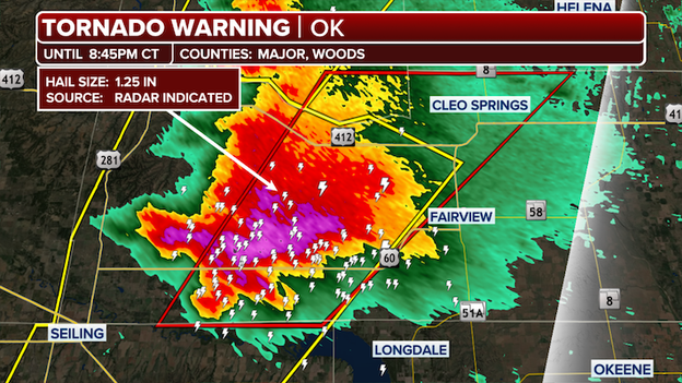
Tornado Warning in Oklahoma
According to the National Weather Service a radar indicated tornado has been observed near Orion, Orienta and Cleo Springs.
Hail up to a half dollar size, 1.25", is also possible.
A Severe Thunderstorm Warning was issued for parts of Briscoe and Hall counties in Texas.
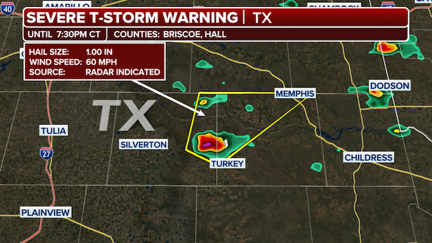
Severe Thunderstorm Warning
The first Severe Thunderstorm Warning of the day features reports of 1" hail and wind speed of 60 mph.
A Tornado Watch has been issued for parts of Oklahoma and Texas until 12 am CST.
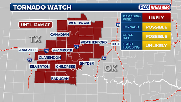
Tornado Watch map
The National Weather Service said a few tornadoes are likely, scattered tennis ball sized 2.5" hail and wind gusts up to 80 mph are all possible in the warned area.
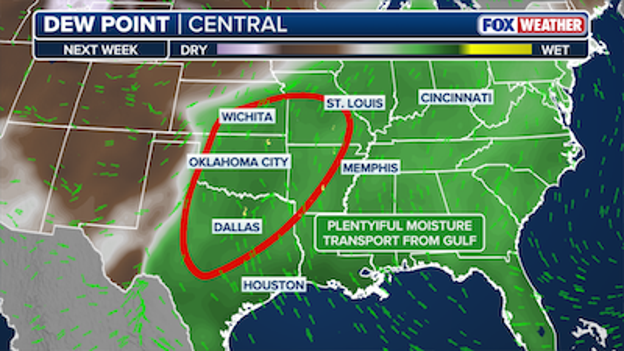
More severe storms are headed to the area early next week.
Just as a multi-day of severe storms is moving through the Southern Plains, another round is already taking shape, continuing the start of severe weather season.
Severe storms are currently engulfing the Southern Plains with heavy downpours, thunderstorms and damaging hail, as the tornado threat increases.
This next round of severe storms is expected to move in Tuesday through Wednesday, as another significant dip in the jet stream is expected to move out of the Rockies and into the Central Plains.
Accompanying this will be a mid-level jet moving northeast ahead of the system, where abundant Gulf moisture will surge northward, increasing instability and allowing storms to develop.
A Level 2 out of 5 severe storm risk is already in place for portions of the southern and central Plains eastward into the Ozarks for Tuesday.
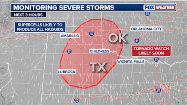
A Tornado Watch could be issued soon.
With severe storms moving into parts of the Texas Panhandle, South Plains and into southwestern Oklahoma tonight, there is a strong likelihood that a Tornado Watch could be issued soon.
The risk of a Tornado Watch being issued tonight is now 80%, and it will likely be issued within the next couple of hours.
The atmosphere across the Southern Plains is officially "reloading" this afternoon as we head into the prime-time window for storm development.
If you’ve stepped outside in Oklahoma City or Tulsa, you’ve likely felt the humidity rising; that’s the warm front pushing north, bringing in the sticky air that serves as fuel for these storms.
While some stubborn clouds have hung around, the FOX Forecast Center says we're finally seeing breaks in those clouds across the Texas Panhandle and Western Oklahoma.
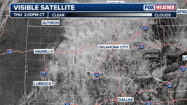
Visible satellite image showing where clouds are breaking up, allowing for heating to occur that will fuel storm development.
This heating is critical because as the sun peeks through, it warms the ground and provides the energy needed to kick-start the afternoon’s activity.
We expect the first supercells—those individual, rotating thunderstorms—to erupt along the dryline near the Caprock Escarpment in Texas between 4:00 p.m. and 6:00 p.m. CT.
Early on, the main concern will be very large hail as these storms tap into that fresh heating. However, as we lose the sun and the low-level jet (a stream of fast-moving air just above the surface) cranks up, the threat will evolve.
This increased wind shear will cause those storms to start spinning more intensely, upping the risk for tornadoes. In fact, the environment is becoming favorable enough that meteorologists cannot rule out a strong tornado (EF2 or higher) as these storms march eastward through the evening.
While the bullseye is on Oklahoma and the Texas Panhandle, we aren't ignoring the neighbors. We are still monitoring a risk for storms stretching farther south into West Texas and even over into the Ohio Valley.
The bottom line: the cap is thinning, the fuel is in place, and the next few hours are the most critical of the day.
As we move deeper into the month, the battle of the seasons begins in earnest across the Lower 48. March is a notorious transition month where the last gasps of winter’s cold air frequently collide with surging warmth and moisture from the Gulf of America.
This clash creates a volatile environment that traditionally shifts the severe weather focus away from the Gulf Coast and deeper into the Heartland and Southeast, as seen in the latest historical probability map.
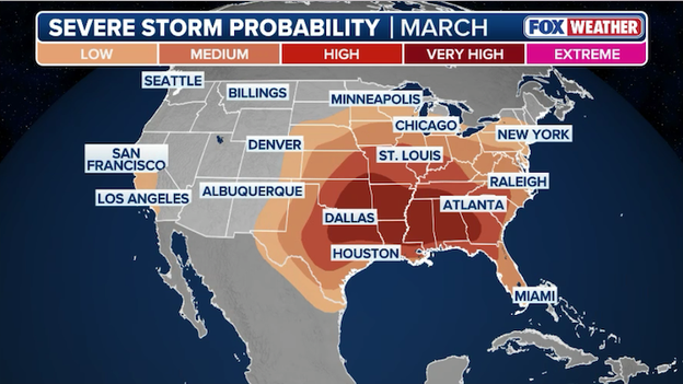
Severe storm probabilities for March (Source: Storm Prediction Center 1994-2024)
As the jet stream begins to retreat north, the threat zone expands toward the Ohio and Tennessee Valleys. You can see the risk area surging up toward St. Louis and Raleigh, marking the beginning of the severe season for the Mid-Atlantic and Midwest.
While the Plains get the most attention, parts of Central and Southern California also maintain a 'low' historical probability in March as late-season Pacific storms can still bring enough energy for isolated severe thunderstorms.
This map is a reminder that we are entering the most active time of year for many Americans. In March, severe weather isn't just a possibility; it's a historical certainty for millions.
Whether it’s tornadoes, damaging winds, or large hail, the geographical engine for these storms is now firing on all cylinders across the central and eastern U.S.
If you’ve looked at a severe weather map this week and felt like you needed a PhD to decode it, you aren’t alone.
The Storm Prediction Center (SPC) recently rolled out a major update to its maps by introducing Conditional Intensity Groups (CIGs). For years, we relied on simple 'hatched areas' to show where intense storms might happen, but the new CIG system adds three specific tiers of intensity.
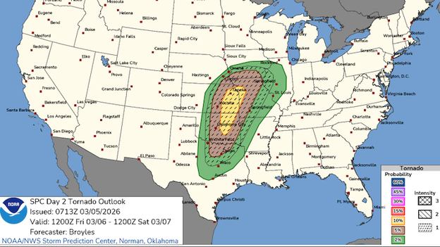
Storm Prediction Center website showing the tornado Conditional Intensity Group for Friday.
The goal is to separate probability (how likely a storm is to hit your house) from intensity (how bad that storm will be if it actually forms).
While this is a win for meteorologists, it’s creating a map fatigue for many everyday Americans who just want to know if they need to hide in the basement or if it's safe to run to the grocery store.
The challenge for us in the weather community is that these new layers—CIG1, CIG2, and CIG3—require us to communicate three different things at once: the overall risk category (1-5), the specific probability of a hazard, and now the "ceiling" of how violent a storm could become.
It’s a lot to digest when you're already worried about a tornado sirens going off.
A CIG1 might mean a threat of strong EF2 tornadoes, while a CIG3 is reserved for historically violent, once-in-a-decade setups.
Balancing this data without causing warning fatigue or confusion is the ultimate hurdle.
At FOX Weather, our job is to strip away the jargon and keep the message simple: regardless of the tier, if you’re in the threat zone, you need to have a plan.
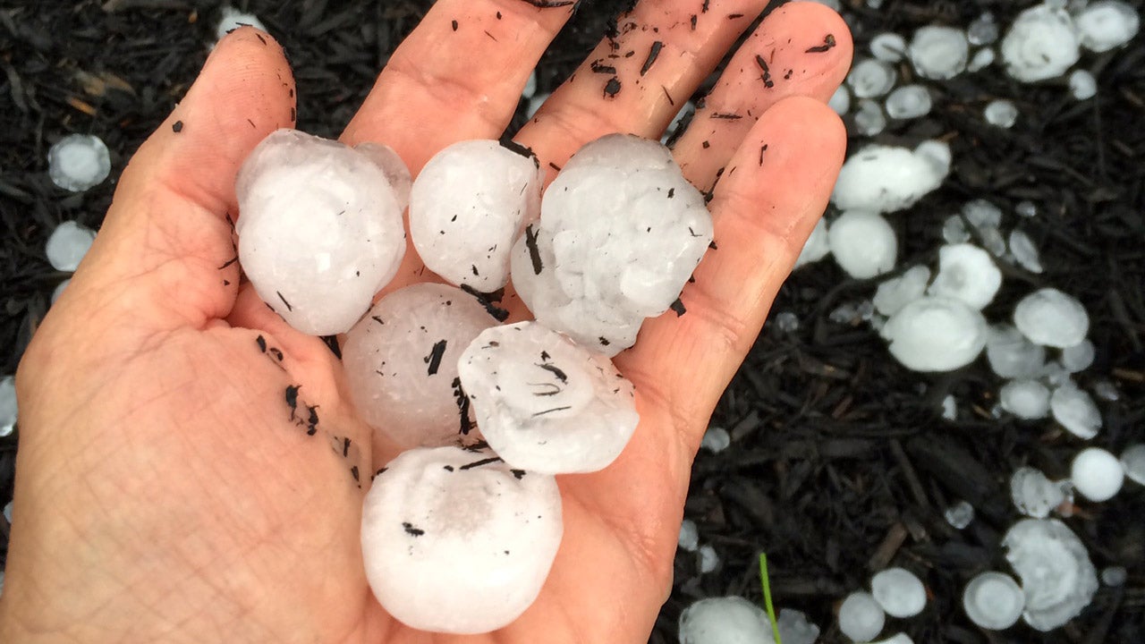
While tornadoes often steal the headlines, the atmosphere over the Plains tonight is primed for a different kind of destructive power: huge hail.
As supercells erupt along the dryline this afternoon and evening across the Texas Panhandle, Western Oklahoma, and Southern Kansas, they will be moving into an environment with incredibly steep lapse rates. In plain English, the air gets cold very fast as you go up. This allows for massive updrafts—upward-moving winds—that act like a trampoline, bouncing ice pellets high into the freezing layers of the storm over and over again until they grow into heavy, jagged stones the size of baseballs or even softballs.
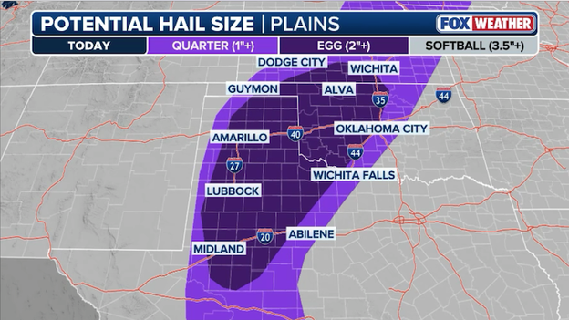
Hailstones larger than baseballs could hammer the Central and Southern Plains later this evening.
The danger with tonight’s hail threat is its after-dark timing. Large hail can be just as life-threatening as a tornado if you are caught outdoors, and it is a leading cause of catastrophic property and vehicle damage.
Because tonight's storms will be discrete—meaning they are standing alone rather than in a solid line—they have more room to breathe and suck up the energy needed to produce these massive stones.

If you live in the path of these storms, now is the time to clear out the garage or find covered parking.
Don't wait until the sirens sound; by the time the wind picks up, the hail is often right behind it, and don't sleep on it is literal advice—make sure your vehicles and pets are protected before the sun goes down.
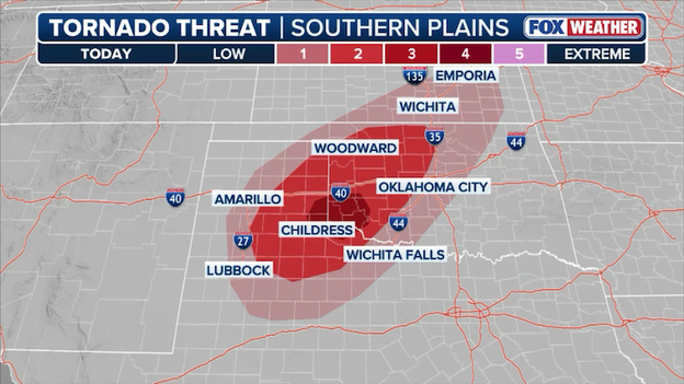
Tornadoes could spin up across Texas, Oklahoma, and Kansas later this afternoon-evening.
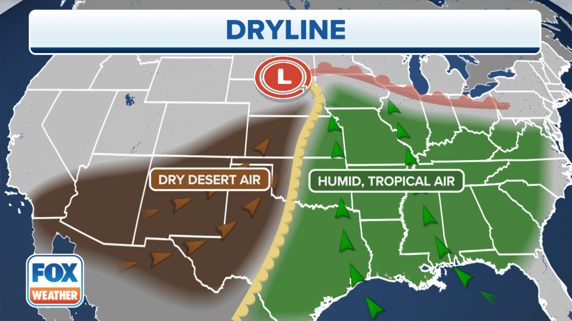
The focus for potential tornado development later today is sharpening over a high-stakes corridor of the Central and Southern Plains. As a powerful dryline—the boundary separating desert air from Gulf moisture—pushes eastward, meteorologists are watching the Texas Panhandle, Western Oklahoma, and South-Central Kansas for the first signs of explosive storm development.
Between 4:00 p.m. and 8:00 p.m. local time, any individual storm that can break the cap (the lid of warm air holding the storms back) will have the potential to rapidly rotate.
While the risk area is broad, the highest concentration of tornadic potential currently targets Southwest Oklahoma.
As we transition into the late evening and overnight hours, these individual supercell storms are expected to cluster together, shifting the primary threat from discrete tornadoes to destructive straight-line winds.
However, the danger doesn't disappear at dark; instead, 'embedded' tornadoes can form within these fast-moving lines of storms as they charge into Eastern Oklahoma and the Ozarks.
And because nighttime tornadoes are twice as likely to be fatal, it is critical to have a way to receive warnings that will wake you up, such as the FOX Weather App or a NOAA Weather Radio, as this system remains active well past midnight.
Meteorologists are seeing some important shifts in the threat zone for Friday's expected severe weather outbreak.
While the atmosphere is still primed for a significant event, the latest technical data suggests the setup is becoming "bimodal"—which is a fancy way of saying the energy is splitting into two main areas of concern rather than one giant shield of storms. FOX Forecast Center meteorologists say there remains considerable uncertainty into the overall expanse of Friday's storms.
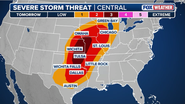
Severe storms are expected to fire up across the central U.S. on Friday afternoon and continue into the overnight hours.
The first area we are watching is up north across Kansas and the Missouri Valley, where storms are expected to fire off mid-to-late Friday afternoon. Because of the way the surface winds are spiraling near the center of the low-pressure system, these initial storms could quickly become supercells capable of producing large hail and a few tornadoes before they clump together into a fast-moving line of wind.
Farther south, the Level 3 out of 5 risk has shifted slightly and is now centered over a corridor stretching from Eastern Oklahoma and North Texas into the Ozarks. This is where the warm conveyor—a river of rich, humid air—is strongest.
While there is some uncertainty about exactly how long individual rotating storms can stay sustained, the environment is undeniably favorable for discrete supercells that could produce very large hail and tornadoes Friday evening.
As the night progresses, a cold front will sweep through, likely turning these individual threats into a powerful line of storms that will push toward the Mississippi Valley.
Whether you are in Tulsa, Little Rock, or Springfield, the message remains the same: the timing may have shifted, but the ingredients for a dangerous afternoon-evening are all on the table.
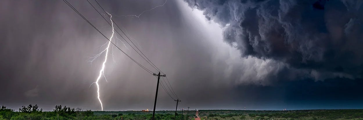
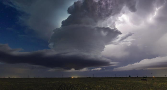
Terrifying video captured the moment a lightning bolt blasted a Central Texas neighborhood on Wednesday. The strike serves as a vivid reminder of the immense power within these storms.
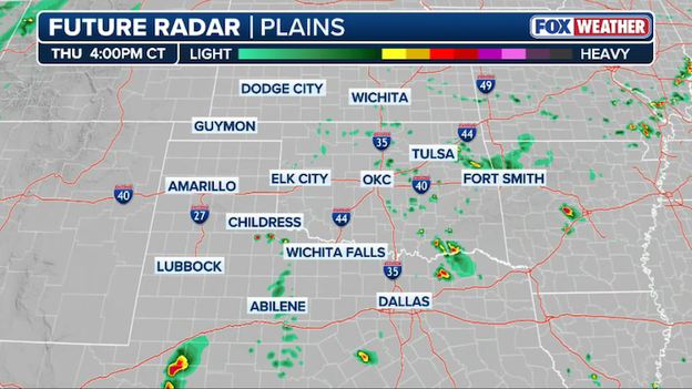
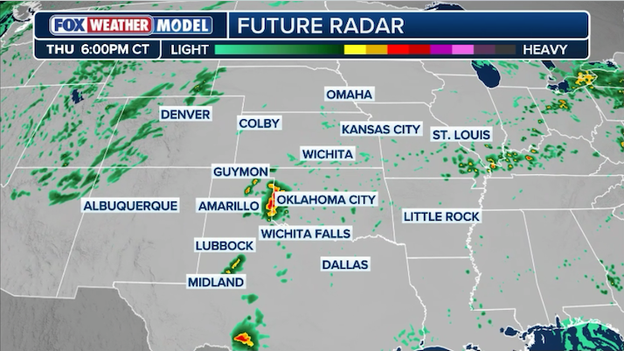
Exclusive FOX Weather Model showing the first storms developing in Texas around 4 p.m. CT today.
Residents across the Southern Plains should be on high alert as the atmosphere begins to prime for explosive storm development between 4:00 p.m. and 6:00 p.m. local time today.
While the morning has been characterized by cloud cover and lingering showers, the arrival of a dryline—the boundary between bone-dry desert air and humid Gulf moisture—will act as the spark for severe supercells to erupt.
The highest risk for these dangerous storms will initially focus on a corridor from Lubbock through the Texas Panhandle and into Western Oklahoma, with the primary threat transitioning into a fast-moving line of damaging winds as the system pushes toward Oklahoma City after dark.
While we are keeping a close eye on the storms today, all signs point to Friday being the main event of this multi-day storm threat.
A powerful jet stream—a river of high-speed air sitting miles above our heads—is expected to punch into the central U.S., acting like a giant engine for storm development.
At the surface, rich moisture from the Gulf of America will surge northward, setting the stage for what FOX Weather meteorologists say could be a significant severe weather event.
By Friday afternoon, forecasters expect a line of explosive storms to fire along the I-35 corridor, stretching from Northeast Kansas through Oklahoma City and down into North Texas.
The atmospheric ingredients coming together Friday are particularly concerning because of the high shear, or the way wind changes speed and direction as you go up in altitude. This creates a spinning environment perfect for supercells—the most dangerous type of individual thunderstorms.
These storms won't just bring rain; they are expected to produce huge hail up to 3 inches in diameter (about the size of a baseball) and a real threat for strong tornadoes (EF-2+). As we move into the evening hours, the atmosphere is expected to become even more volatile as the wind energy intensifies, likely causing these individual storms to merge into a powerful line that will race toward the Ozarks and Mississippi Valley.
To understand why Friday is so concerning, meteorologists look at hodographs, which are charts that show us how the wind is curving in the lower atmosphere.
On Friday evening, these charts show a lot of curvature, meaning there is a high amount of storm-relative helicity. In plain English: the air is primed to twist. This is a classic signature for long-tracked tornadoes.
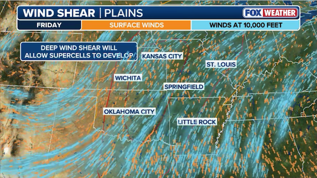
Wind shear, or a turning of winds with height, will help supercell thunderstorms to develop on Friday.
Whether you are in Wichita, Tulsa, or Dallas, Friday is the day to be at your highest state of readiness.
Have your safe spot picked out, keep your phone charged, and make sure your FOX Weather App alerts are set to "loud."
A powerful, multi-day severe weather event is continuing its march across the Heartland today, placing more than 10 million people in the crosshairs of dangerous storms.
After a Wednesday marked by flooding and structural damage in North Texas, the focus for Thursday shifts to a broad corridor of the Central and Southern Plains.
A volatile mix of Gulf moisture and an advancing dryline is expected to trigger explosive storm development from Lubbock, Texas, through Oklahoma City, and up into Omaha, Nebraska.
Forecasters are warning that any storms breaking through the atmospheric cap this afternoon could quickly become supercells capable of producing large, damaging hail, wind gusts over 70 mph, and tornadoes.
As the sun sets, the threat won't diminish; instead, these individual cells are expected to merge into a fast-moving line of storms, bringing a risk of destructive straight-line winds to the Mid-Mississippi Valley overnight.
Widespread severe thunderstorms are expected across the central U.S. on Friday.
This persistent activity is setting the stage for what could be an even more significant outbreak on Friday that could feature numerous strong tornadoes, widespread destructive winds, and damaging hail across across nearly 10 states.
And with soils already saturated from morning downpours in the Ozarks and Ohio Valley, additional heavy rain today will heighten the risk for flash flooding.
Residents across the Plains should remain weather-aware and ensure their FOX Weather App alerts are active, as today's activity is a critical prelude to the higher-end severe threat looming for the end of the week.
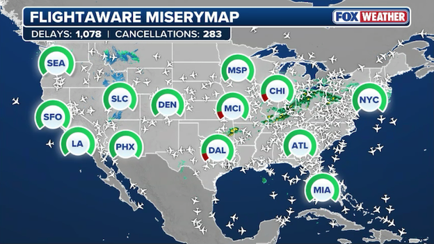
FlightAware MiseryMap showing flight disruptions across the United States.
Travelers across the country are facing a turbulent day at the airport as rain and storms stretching from the Northeast to Texas trigger significant air traffic disruptions.
The FAA has warned of potential ground stops and arrival delays for major hubs including JFK, Newark, and LaGuardia as rain moves through these critical flight corridors.
If you are heading to the airport today, be sure to check your flight status early and often, as these weather-related delays are expected to ripple through flight schedules nationwide well into the evening.
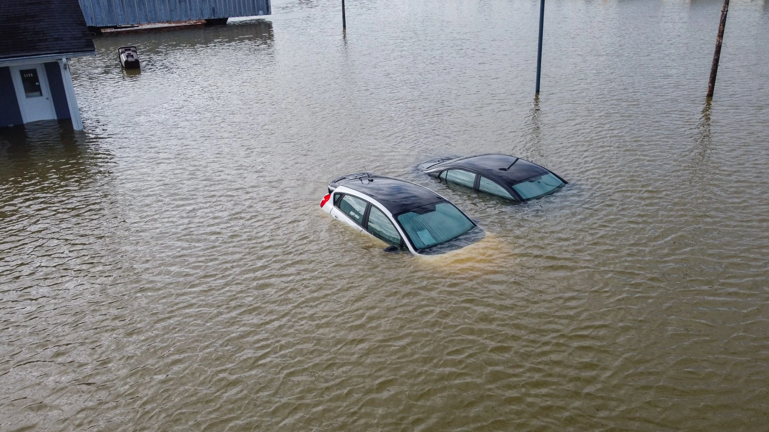
The Dallas-Fort Worth Metroplex is drying out this morning after a relentless deluge on Wednesday triggered widespread flash flooding and several building failures.
Emergency crews responded to multiple reports of roof collapses under the weight of the water, while several major thoroughfares were left impassable as rain totals quickly overwhelmed North Texas drainage systems.
Watch
What it means: This type of statement is issued when dangerous weather is forecast to occur and widespread impacts to life and property are expected. It means forecasters believe conditions are right for severe weather to happen.
You can think of this as the National Weather Service’s way of saying, "Be on the lookout for severe weather."
What you should do: Prepare for the type of severe weather that is indicated in the watch. This means reviewing your safety plans so that you are ready to take action if a warning is issued.
Example: If a Tornado Watch is issued for your area, it means forecasters believe tornadoes are possible with any storms that develop.
You should review your tornado safety plan, which means knowing how to get to the lowest level of the building you are in and how to locate an interior room with no windows on that floor.
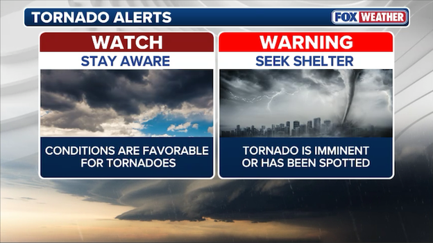
Watches and Warnings are issued to alert Americans to the threat of severe weather.
Warning
What it means: This type of statement is issued when severe weather is occurring and poses an immediate danger to life and property.
What you should do: Take action, meaning you should immediately execute your safety plan for the type of severe weather that is indicated in the warning.
Example: If a Tornado Warning is issued for your area, it means meteorologists have detected a possible tornado on radar or a trained storm spotter has reported seeing a tornado.
You should immediately go to your storm shelter. If you don’t have a storm shelter, get to the lowest level of the building you are in and head to an interior room with no windows. The goal is to put as many walls between you and the tornado as possible. Make sure to cover your head.
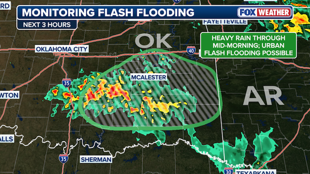
Radar shows a cluster of thunderstorms pounding Oklahoma with intense rain this morning.
A slow-moving cluster of storms is currently drenching Southeast Oklahoma, and it’s showing signs of back-building—a term meteorologists use when new storm cells continuously form on the backside of the main group.
Think of it like a train where new cars are constantly being added to the back while the front stays over the same tracks; this leads to training, where heavy rain falls over the exact same neighborhoods for hours.
Because these storms are tapping into a low-level jet (a fast-moving stream of moisture-rich air) and a stationary front, they have a constant fuel source. This is leading to incredibly high rain rates of up to 2 inches per hour, which is more than enough to overwhelm drainage systems and cause rapid flooding.
The big concern through mid-morning will be urban flash flooding, especially in cities across Pittsburg and Latimer counties. Even though the overall energy in the atmosphere is only modest, the way these storms are anchoring themselves means an additional 2 to 4 inches of rain could fall in a very short window.
The FOX Forecast Center says these storms will persist into the late morning and eventually push into Western Arkansas.
If you are driving in these areas, remember that most flash flood fatalities occur in vehicles—if you encounter a flooded roadway, "Turn Around, Don't Drown," as the road beneath the water may already be washed away.
If you’ve been watching the radar this morning, things might look relatively quiet across the Plains, but don't let this fool you. FOX Weather Meteorologists are keeping a close eye on an invisible battle happening in the sky today—a phenomenon we call "the cap."
Think of the cap (or capping inversion) like a literal lid on a pot of boiling water. Down at the surface, we have instability building—that’s the warm, moist air acting as the fuel.
Normally, that warm air wants to rise, cool, and form massive clouds. However, today there is a layer of even warmer air sitting just a few thousand feet up. Since warm air is lighter than cool air, that lid traps the moisture at the surface, preventing storms from firing early in the day.
The breaking point
For severe storms to happen, that lid has to break. According to the latest computer model data, afternoon heating across the Texas Panhandle and Western Oklahoma should be just strong enough to poke holes in the cap by late today.
When the cap finally breaks, it’s often explosive. All that trapped energy is released at once, leading to storms that go from zero to sixty in minutes. This is why we are concerned about supercells—those long-lived, rotating thunderstorms—developing rapidly between 4:00 p.m. and 6:00 p.m..
The ingredients for trouble
Once those storms break through the cap, they’ll have everything they need to become dangerous:
- Steep lapse rates: This is a fancy way of saying the temperature drops very quickly as you go higher in the sky. This acts like a vacuum, sucking the air upward at incredible speeds.
- Veering winds: As you move from the ground up to the jet stream, the winds are changing direction (turning like a corkscrew). This is the shear that gives storms their rotation, increasing the risk for tornadoes and very large hail.
Exclusive FOX Weather Model showing thunderstorms erupting across Oklahoma and Texas this evening.
What to watch later today
As we head into the evening, these individual supercell storms will likely clump together into a bowing structure.
Imagine a line of storms curving outward like a literal archer’s bow; this is a signal that the storm is breathing out very powerful, destructive straight-line winds.
While the cap might keep things quiet for most of the day, it’s essentially just wound the spring tighter for the evening.
Keep your FOX Weather app alerts turned on—once the lid pops, things will move fast.
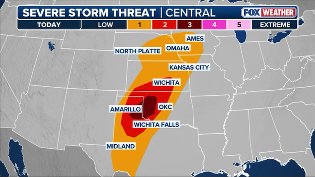
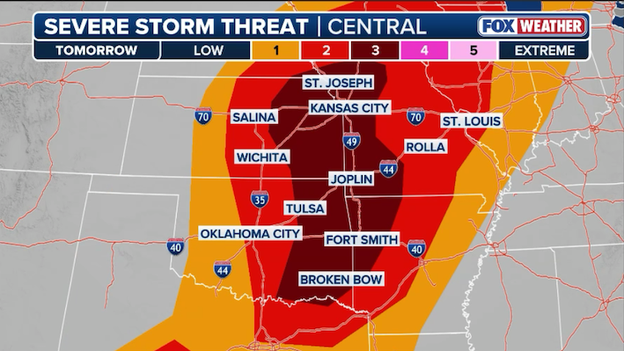
A Level 3 of 5 severe storm threat area spans Oklahoma and Texas for the threat of dangerous storms later today.
A volatile atmospheric setup is taking shape today across the Central and Southern Plains as a potent low-pressure system pulls a surge of warm, unstable air northward from the Gulf of America.
This moisture is set to clash with an advancing dryline, sparking a severe weather threat that spans a broad corridor from Lubbock, Texas, through Oklahoma City, and up into Wichita and Omaha.
The FOX Forecast Center is particularly concerned with late-afternoon supercell development, as these discrete storms will have the potential to produce very large hail, damaging wind gusts over 70 mph, and a few tornadoes.
As the evening progresses, these individual storms are expected to congeal into a dangerous line or cluster of storms, shifting the primary threat toward destructive straight-line winds as they move into the Mid-Mississippi Valley.
Because many of these storms will persist after sunset, it is critical for residents in the path of the system to have multiple ways to receive warnings overnight.
This activity is only the prelude to an even more significant severe weather outbreak forecast for Friday, making today an essential time for those in the Heartland to finalize their emergency plans.
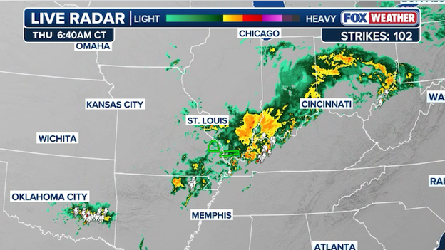
Radar showing thunderstorms hammering parts of the Ohio Valley, Ozarks, and Oklahoma this morning.
The morning has gotten off to a soggy start as a complex of rain and thunderstorms tracks across the Ozarks and into the Ohio Valley, bringing downpours to cities like Evansville, Indiana, McAlester, Oklahoma, and Louisville, Kentucky.
These storms are tapping into an unseasonably moist air mass—boasting moisture levels nearly three times the March norm—which increases the risk of localized flash flooding in areas already saturated from yesterday’s rain.
While this morning activity is largely sub-severe, it is helping to set the stage for a much more volatile environment later today as the primary storm system reloads over the Plains.
The severe weather threat today is part of a multi-day event that began yesterday with flooding and storm damage across the South and Ohio Valley.
You can catch up on the initial round of storms, including the significant flash flooding in Dallas, in yesterday’s live coverage here.
You’ve reached the beginning of this live coverage.