Live updates: Dangerous multi-day severe storm outbreak begins with potential tornadoes in Heartland
Live updates: Dangerous multi-day severe storm outbreak begins with potential tornadoes in Heartland
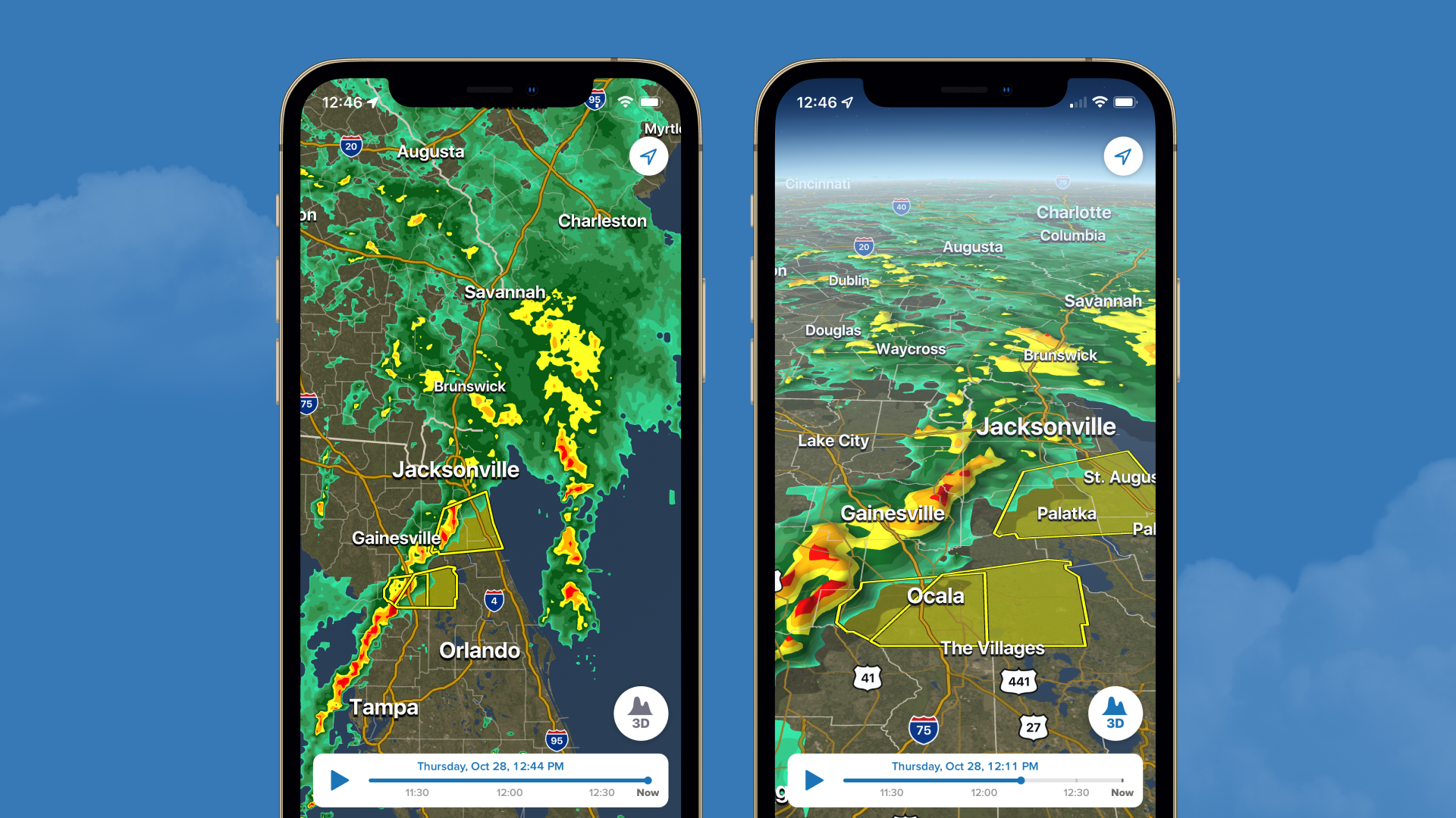
Download the AppLIVE Severe Weather HQ coverage continues
View postCoverage for this event has ended.
LATEST UPDATES: This severe weather outbreak is shifting into a more dangerous phase today, March 5, with an elevated risk of life-threatening tornadoes across the Heartland.
Follow our new live blog here for real-time storm tracking, radar, and the latest alerts.
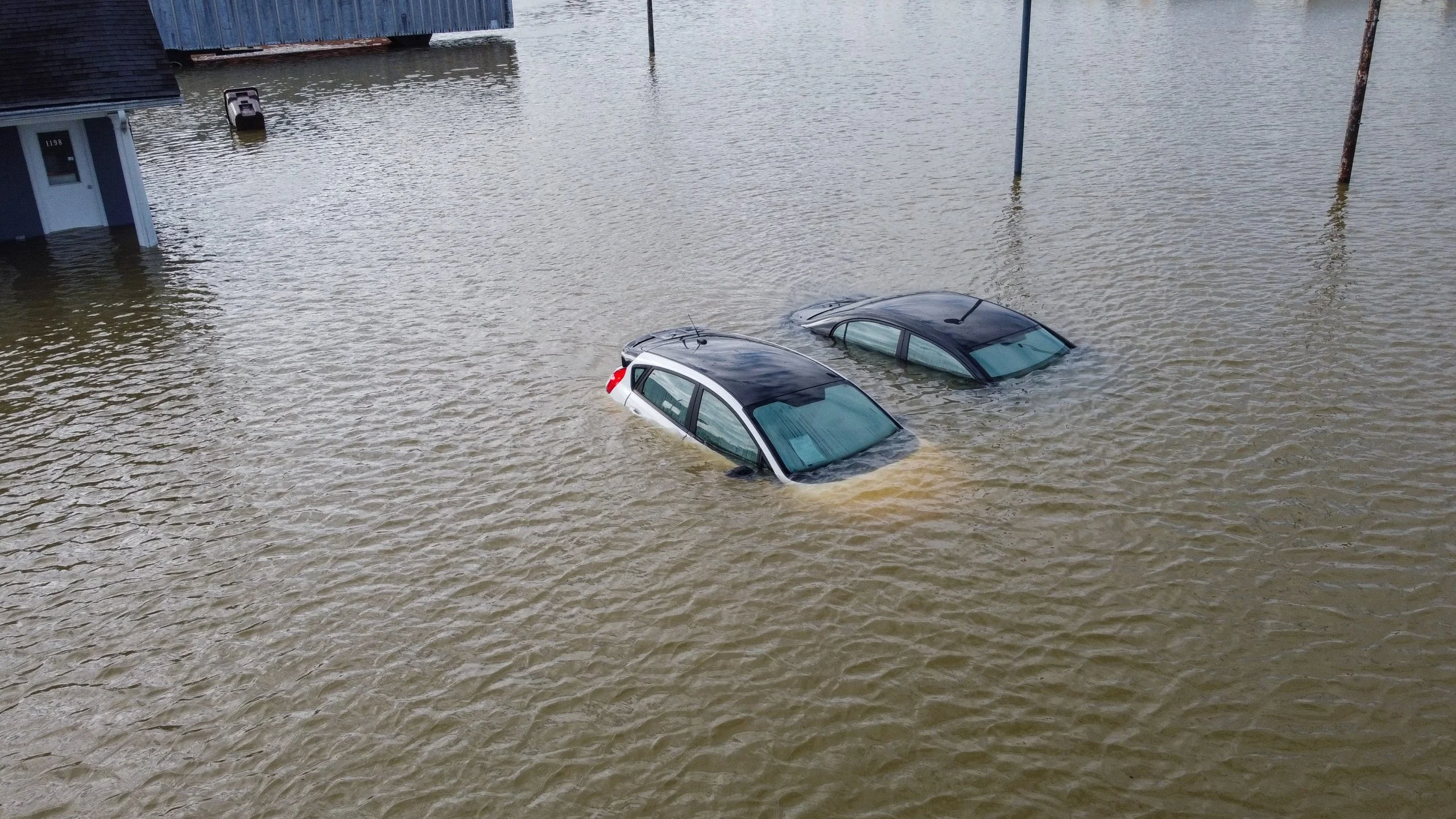
Flash flooding has inundated sections of Interstate 20 near Dallas, Texas, as heavy rainfall left portions of the major highway submerged.
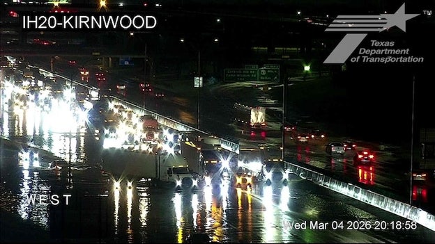
Courtesy of Texas Department of Transportation
A Texas Department of Transportation traffic camera at I-20 and Kirnwood captured footage of tractor-trailers and passenger vehicles attempting to navigate around and through standing floodwaters, creating hazardous driving conditions.
Flood and rain reports across Dallas County are pouring in as thunderstorms continue to slam the north central Texas area.
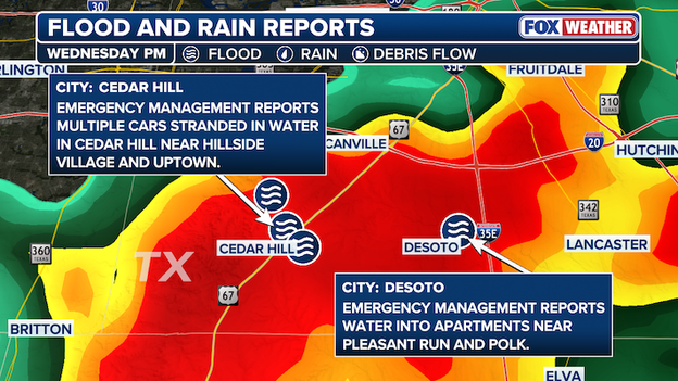
Flood and Rain Reports in Dallas County
In Cedar Hill, there are reports of multiple cars stranded in water near Hillside Village and Uptown.
Multiple ongoing water rescues in Cedar Hill have been reported by emergency management officials.
In Desoto, water has entered apartments as heavy rain continues to soak the area.
Across Dallas County, several roads remain closed due to flooding in Rowlett and Mesquite.
FOX Weather Meteorologist Steve Bender is joined by Storm Tracker Corey Gerken live from Oklahoma as severe storms sweep across Texas. Thunderstorms packing heavy rain are moving through the Lone Star State.
Emergency Management has reported ongoing water rescues in Dallas County as heavy rain continues to fall in Texas.
The National Weather Service has upgraded the flash flood damage threat to considerable as at least 3 inches of rain has fallen across parts of Dallas County in the past several hours.

Flash Flood Warning for Dallas County
"Dangerous flash flooding is occurring or is imminent. Do not attempt to travel unless you are fleeing flood waters. If you are in an area subject to flooding, move to higher ground now," the Flash Flood Warning said.
According to the warning, several roads in the area are closed.
With flash flooding on-going, an additional 1 to 2 inches of rain is forecast to fall. The Flash Flood Warning remains in effect until 8:30 p.m. CST.
Severe storms continue to batter Texas with heavy rain, triggering flash flood threats across several counties.
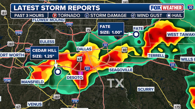
Latest Storm Reports from the FOX Forecast Center
Latest storm reports from the Lone Star State include hail reports in Dallas and Rockwall Counties.
In Cedar Hill, a report of 1.25" hail, larger than a 25 cent quarter, was reported over the past three hours.
In Fate, located in North Texas, 1" hail has been reported.
Flash Flood Warnings have been issued across Dallas County and parts of southeastern Tarrant County as heavy rain continues across north central Texas.
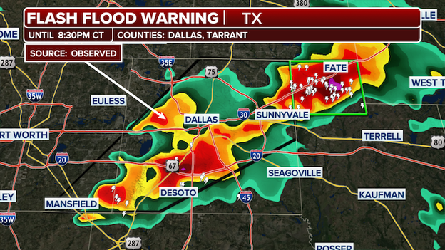
Flash Flooding observed in Dallas County
According to the National Weather Service, emergency management has reported several roads have been closed due to flooding in the area, especially across portions of Northeast Dallas County as rainfall totals.
Between 1 and 2 inches of rain have fallen, with additional rainfall amounts of 1 to 3 inches forecast.
The Flash Flood Warning is in effect until 8:30 p.m. CST. Additional road closures are expected as thunderstorms with heavy rain continue.
The National Weather service urged Texans to "Turn around, don't drown" when encountering flooded roads.
Parts of Texas, Oklahoma and Arkansas are now under Severe Thunderstorm Watch until 11 p.m. CST.
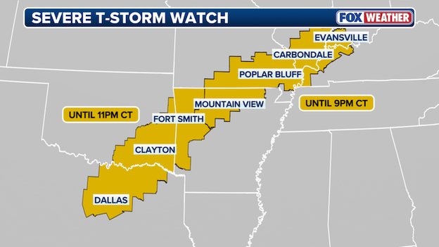
Severe Thunderstorm Watch active until 11pm CT
The watch stretches from Dallas, TX into Fayetteville, AR, and is threatening over 9 million people across the three states with possible tornadoes, scattered hail and wind gusts reaching 70 mph.
The Storm Prediction Center's Severe Thunderstorm Watch is not only the first of 2026, but the first issued since November 23, 2025.
While the watch in itself isn't unique, the Severe Thunderstorm Watch ends the 101 day gap without such watch in the U.S., the longest stretch in least 20 years.
According to data compiled by the Iowa Mesonet, the only comparable stretches are a 90-day period from December 24, 2014, to March 24, 2015, and a 73-day stretch from October 29, 2009, to January 10, 2010.
The issuance of the Severe Thunderstorm Watch ends the longest such stretch in at least 20 years, according to Iowa Mesonet records, which date back to 2005.
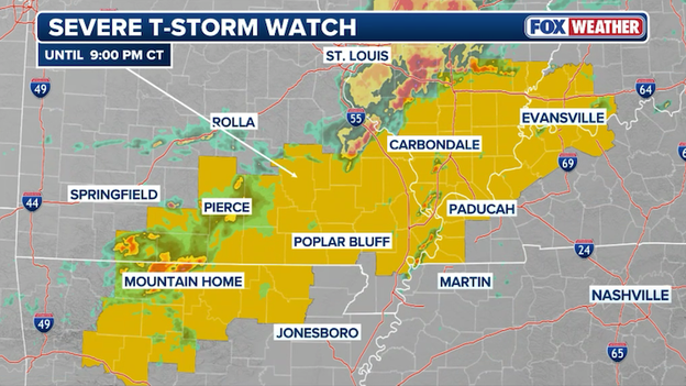
The Storm Prediction Center has issued a Severe Thunderstorm Watch until 9 p.m. CT.
The FOX Forecast Center is tracking a newly issued Severe Thunderstorm Watch as a volatile line of storms begins to fire along a cold front stretching from the Ozarks into the Ohio Valley.
Notably, this is the first Severe Thunderstorm Watch issued by the Storm Prediction Center in 2026.
Residents in southern Missouri, northern Arkansas, and parts of Kentucky and Illinois should be prepared for rapidly changing conditions through this evening.
The atmosphere in these regions has become highly unstable, providing the"fuel necessary for storms to grow quickly and turn severe.
Hail up to 2 inches in diameter, which is the size of hen eggs, 70 mph damaging winds, and a couple tornadoes are expected.
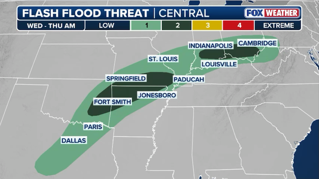
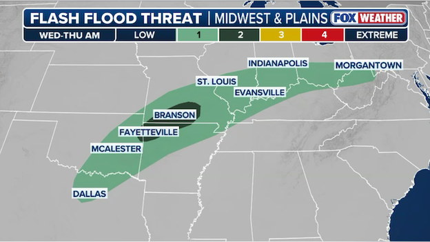
Flash flooding is possible across 10 states as storms "train" over the same areas along a slow-moving storm system.
A powerful and slow-moving storm system is currently tracking across the heart of the country, triggering flash flood concerns for millions of residents across 10 states.
From the Southern Plains through the Ohio Valley, an unseasonably moist air mass—containing up to three times the normal amount of water for early March—will fuel rounds of training storms that will repeatedly dumping heavy rain over the same communities.
While the Ozarks in Missouri and Arkansas are facing a bullseye of 3 to 5 inches of rain, previously soaked areas in Indiana, Ohio, and Illinois are seeing a rapid rise in stream levels, prompting the issuance of widespread Flood Watches.
With rain rates potentially overwhelming urban drainage systems in cities like Dallas and St. Louis, FOX Weather meteorologists warn that the threat will persist well into the overnight hours as this multi-day weather event continues to unfold.
If you are living in parts of Illinois, Indiana, or Ohio, it is time to keep a close eye on the sky and your local weather alerts. A Flood Watch has just been issued as a slow-moving weather system prepares to drench the region with another round of heavy rain.
For many in the Ohio Valley, the ground is already soaked from one to three inches of rain that fell last night, meaning any new downpours will struggle to soak into the earth and instead turn into dangerous runoff.
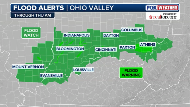
A Flood Watch stretches across portions of Illinois, Indiana, and Ohio through Thursday morning.
Forecasters have officially expanded the Level 2 of 4 area for flash flooding today to include more of Eastern Oklahoma, Northwest Arkansas, and Southern Missouri.
While the ground in the Ozarks started the day relatively dry, the sheer volume of moisture in the air—which is at record-high levels for this time of year—is expected to prime the soil quickly.
Rght now, we are concerned about training today, where storms follow one another over the same path like railroad cars.
This setup could easily dump 3 to 5 inches of rain in localized spots over the next 12 to 18 hours.
Southern Indiana and Ohio are looking at an additional 1 to 2+ inches of rain on top of already swollen streams, which could easily trigger flash flooding.
Governor Greg Abbott has officially activated Texas state emergency response resources as a multi-day severe weather threat prepares to hammer the state through the weekend.
With the National Weather Service forecasting severe weather from North Texas today toward the Panhandle and Permian Basin by Thursday, the state has deployed specialized teams, including Texas A&M Task Force boat squads for swiftwater rescues and National Guard personnel with high-profile vehicles to assist stranded motorists.
Texas stands ready to deploy all necessary resources to help local officials respond to potential severe weather across the state.
State officials are urging all Texans to remain weather-aware and have an emergency plan in place as these multiple storm systems move through.
Resources from the Texas Department of Transportation are actively monitoring road conditions, while saw crews from the Texas A&M Forest Service stand ready to clear debris from impacted roadways.
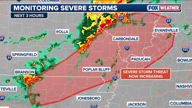
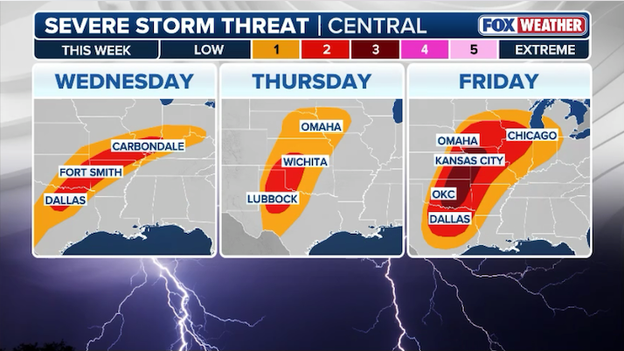
- The Threat Zone: A multi-day severe storm outbreak begins today across the Heartland of America. Today’s primary focus is on severe storms stretching from Northeast Texas and Eastern Oklahoma through the Mid-Mississippi Valley and into Western Kentucky.
- Primary hazards: A couple tornadoes, damaging wind gusts over 60 mph, and large hail (up to the size of quarters) are the main threats through this evening.
- Flash flood threat: Heavy rain is training over the same areas in Kentucky, Tennessee, and Southern Illinois. Rain totals of 1–3 inches (with local 4-inch amounts) could trigger localized flash flooding.
- Outbreak brewing: Forecasters are already warning of a more significant outbreak of severe weather on Friday, targeting a broad corridor from Texas to Wisconsin with strong tornadoes, huge hail, and destructive winds.
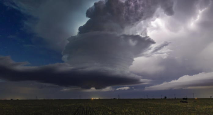
Severe thunderstorms will target the Central U.S. this week with tornadoes, damaging winds, and large hail.
When severe weather is happening, meteorologists at the National Weather Service will issue a variety of alerts to keep you informed about the dangers you could face with tornadoes. Some alerts are more urgent than others, and knowing their differences can help you stay safe. The primary goal of any alert issued by the NWS is to protect life and property.
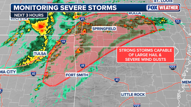
Forecasters are monitoring parts of the Ozarks for damaging winds, hail, and a couple tornadoes in the hours ahead.
We’re keeping a close eye on the Ozarks and the lower Ohio Valley this afternoon as the atmosphere begins to prime itself for severe weather.
While we’ve seen some messy, disorganized storms so far, the air is becoming much more unstable as warm, humid air with dew points in the 60s flows into the region.
FOX Weather meteorologists are watching to see if the current storms—or perhaps some new ones—can tap into this increasing fuel to become more intense as they push toward southern Missouri and northern Arkansas.
If these storms can find a sweet spot in the warmer air, they could quickly organize into clusters or even rotating supercells capable of producing large hail and damaging wind gusts.
There is even enough spin in the lower atmosphere to support a tornado or two if a storm can stay strong enough.
Right now, the Storm Prediction Center is monitoring the area for a potential Severe Thunderstorm or Tornado Watch.
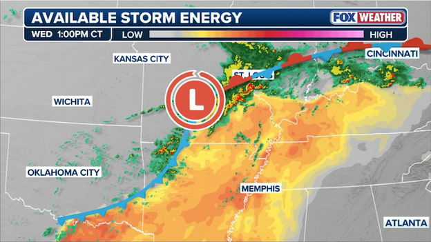
Atmospheric instability is increasing across parts of the central U.S. right now.
The atmosphere is priming itself this afternoon across southern Missouri and northern Arkansas as warm, humid air surges northward ahead of a slow-moving cold front.
This influx of Gulf moisture is driving up instability—the essential storm fuel that allows air to rise rapidly and form towering thunderstorms.
With temperatures climbing and the front providing the necessary spark, the FOX Forecast Center expects a round of strong to severe storms to blossom as the afternoon progresses.
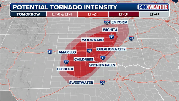
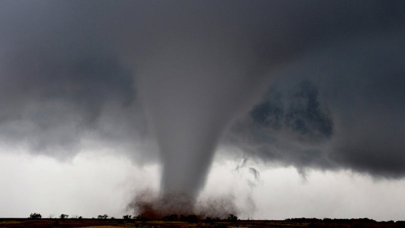
Strong tornadoes (up to EF-2) are possible across parts of Texas and Oklahoma on Thursday.
Dangerous storms are expected to erupt across Oklahoma, Texas, and Kansas on Thursday, producing damaging winds, hail, and tornadoes.
Most notably, forecasters are warning of a significant tornado threat, with the potential for storms to reach EF-2 strength or stronger. Using the new Conditional Intensity (CIG) tools implemented this week, the SPC is able to differentiate these high-intensity threats, even when storm coverage remains scattered.
While the day may start with isolated showers, a round of dangerous supercells is expected to develop after 4:00 p.m. or 5:00 p.m., bringing the risk of hen-egg-size hail and damaging wind gusts to 75 mph.
As these supercells track northeast through the evening, they may merge into lines or clusters, potentially reaching the Oklahoma City metro area overnight.
Now is the time to download the FOX Weather App for critical weather alerts and real-time interactive radar to stay ahead of the storms.
The weather is turning more active across the Ozarks this afternoon as a lingering front begins to interact with the day's heating.
While we’ve already seen some hail-producing storms moving through southern Missouri and into Kentucky, the focus is shifting toward "surface-based" storms that could develop mid-to-late afternoon.
This means that instead of staying high in the atmosphere, new storms will be able to tap into the warm air near the ground, increasing the risk for damaging wind gusts and large hail as they form into clusters and rotating supercells.
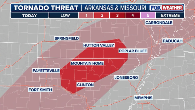
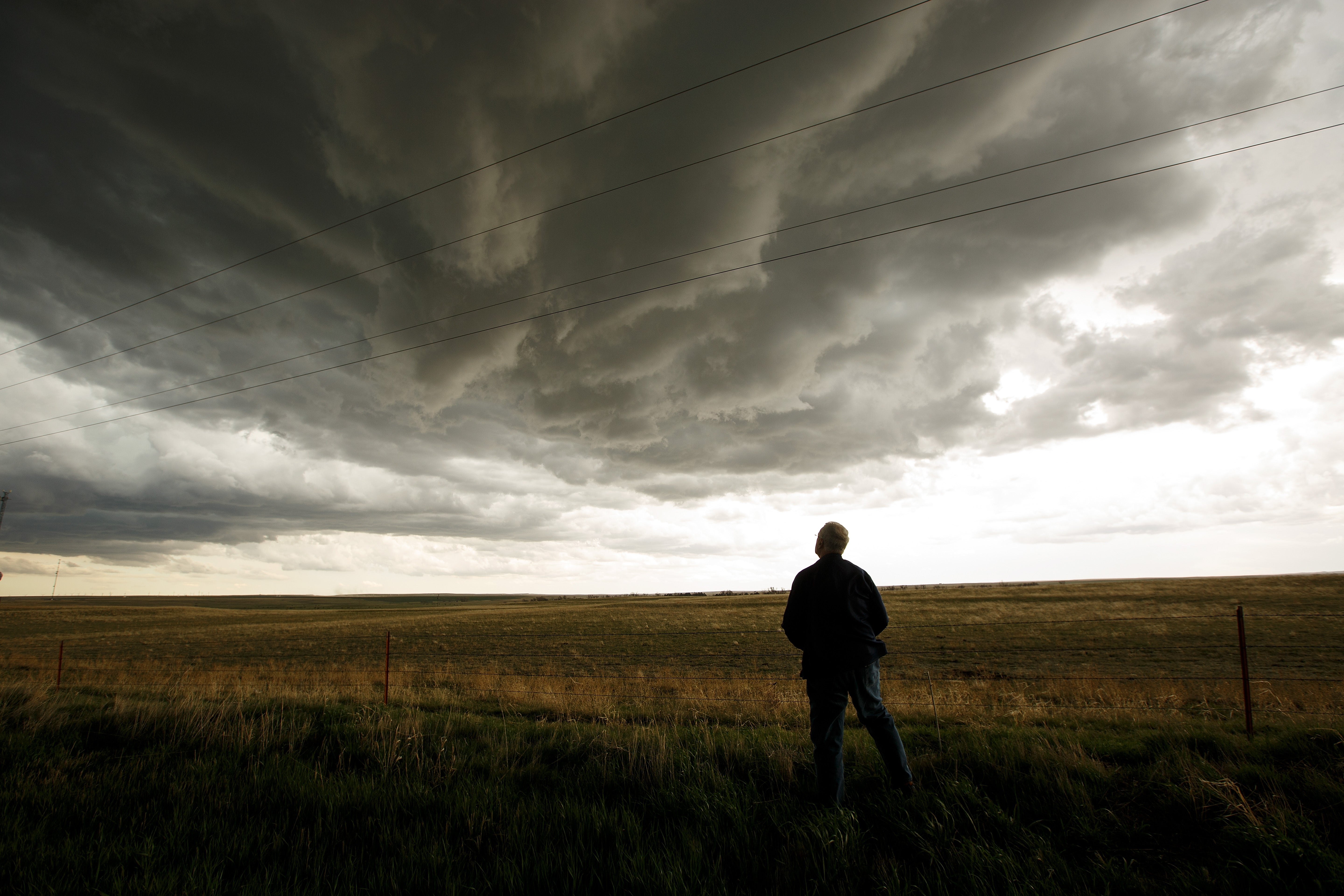
Southern Missouri and northern Arkansas are at risk for tornadoes through the evening hours.
For those in southern Missouri and northern Arkansas, the threat of a couple of tornadoes is also on the rise. Even though the winds near the surface aren't incredibly strong, there is just enough spin in the atmosphere—what meteorologists call Storm Relative Helicity—to allow some of these stronger storms to rotate.
If a storm can stay isolated and sustained, it will have the best chance of producing a tornado, making it vital to have a way to receive warnings through tonight.
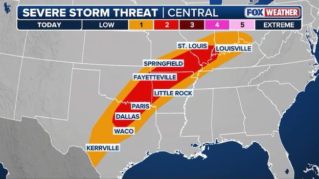
The first severe weather outbreak of 2026 is brewing across the central and southern United States, driven by a surge of Gulf moisture meeting a slow-moving cold front.
For this afternoon and evening, a Level 2 of 5 risk area spans from northeast Texas through the Ohio Valley, bringing threats of 60-mph wind gusts, large hail, and isolated tornadoes.
Additionally, heavy rain of 1–3 inches poses a flash flood concern for the Tennessee and Ohio Valleys.
Severe thunderstorms are forecast to develop each afternoon-evening across the central U.S. through Friday.
The weather threat is expected to intensify through the end of the week, with Friday currently forecast as the most active day. The Storm Prediction Center has already issued a Level 3 of 5 risk for parts of the Plains and Missouri Valley, where rotating supercells could produce strong tornadoes.
Residents in major hubs like Dallas, Oklahoma City, and St. Louis should stay weather-aware as forecasters utilize new Conditional Intensity (CIG) tools to highlight the potential for particularly violent storm development.
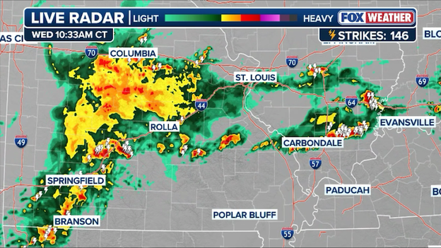
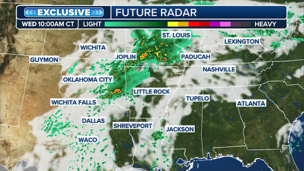
Radar showing thunderstorms striking Missouri and Illinois.
The FOX Forecast Center is tracking clusters of thunderstorms rolling across Missouri at this hour, dousing the state in heavy rain.
Numerous lightning strikes have been detected as the storms hit Springfield, Jefferson City, and Columbia.
With repeated rounds of heavy rain expected in the next few days, the threat for flash flooding will increase with time.
FOX Weather meteorologist Craig Herrera breaks down the increasing threat of severe weather across Americas as we enter March.
Thunderstorms could "train" over the same areas through tonight and increase the risk for flash flooding.
The FOX Forecast Center is closely tracking a stalled weather front that is setting the stage for a serious flash flooding threat through tonight.
A slow-moving storm system is pulling an incredible amount of moisture up from the Gulf of America—in fact, the atmosphere is holding two to three times more water than it normally does this time of year. This soggy air is ready to pour as multiple waves of storms track across the same areas.
While the morning may only see light to moderate rain, the threat ramps up significantly this afternoon and evening. We are watching a bullseye of heavy rain develop over the Ozarks, stretching from eastern Oklahoma and northwest Arkansas into southern Missouri.
A low-level jet—a fast-moving river of air about 5,000 feet up—will kick into high gear later today, acting as a conveyor belt to dump even more rain into the region.

Many areas will see a widespread 1–2 inches of rain, but the hardest-hit spots in the Ozarks could see 3–5 inches by tomorrow morning.
Because these storms are training—meaning one storm follows another over the exact same path—the ground will quickly become saturated, leading to a high risk of flash flooding.
When severe weather is brewing, you'll likely see social media posts referencing "SPC" risks such as "Slight," "Enhanced," "Moderate" or "High."
An example might be: "The SPC is giving Enhanced Risk of severe weather over Oklahoma today while north Texas is in the Slight Risk category."
"SPC" refers to NOAA's Storm Prediction Center, based in Norman, Oklahoma and monitors severe weather threats around the nation that include the potential for tornadoes, thunderstorms, damaging hail and wind.
When severe weather is possible, NOAA's Storm Prediction Center will issue color-coded risk categories over geographic areas that represent the level of perceived threat.

When watching FOX Weather, you'll see those risks simplified into a Level 1 through 5, with 5 being the most extreme.
A few severe thunderstorms are possible across Missouri, Oklahoma, and Arkansas this morning.
Heads up if you’re waking up in northeast Oklahoma or southwest Missouri—the weather is already starting to get a bit noisy this morning. We are seeing a shortwave, which is basically a ripple of energy in the atmosphere, moving through the region and sparking a cluster of storms.
Even though it's early, these storms have found a pocket of very high fuel in the atmosphere, known as instability, which is allowing them to grow stronger than your typical morning shower.
Because these storms are elevated—meaning they are riding high above the cooler air near the ground—the main things we're watching for over the next few hours are large hail and some heavy wind gusts.
These storms are moving along a stalled front, so if you are in their path, don't be surprised to hear some loud rumbles of thunder or see some hail falling.
We expect this specific morning threat to stick around for a few more hours before the focus shifts to more storm development later this afternoon.
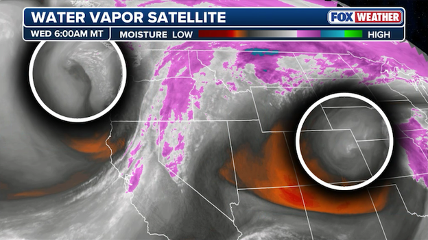
Water vapor satellite image showing the two disturbances that will help trigger severe weather this week in America.
The FOX Forecast Center is closely monitoring two disturbances spinning in the atmosphere--one over the central High Plains and another just off the coast of the Pacific Northwest.
These two "shortwaves" will be the primary triggers for severe weather and flash flooding this week.
In meteorology, a shortwave is a smaller-scale disturbance or ripple in the upper-level air patterns that moves through the larger jet stream. These compact waves provide the necessary lift to help air rise rapidly, often acting as the spark that ignites severe thunderstorms.
Morning clouds could help to limit the severity of thunderstorms later this afternoon in the central U.S.
One factor FOX Weather meteorologists are watching for in today's severe weather threat is the morning cloud cover.
If the clouds from this morning's rain and storms linger too long, they could act like a blanket, preventing the ground from heating up and potentially limiting how severe the afternoon storms become.
Thunderstorms are fueled by instability, which occurs when warmer, moist air near the ground is topped by significantly cooler air aloft. As this buoyant warm air rises rapidly, it condenses to form massive clouds and intense updrafts, providing the energy needed for severe weather like large hail and tornadoes.
However, even with that uncertainty, the risk remains broad enough that anyone from North Texas to the Ohio Valley should be prepared for severe thunderstorms later today.
Severe storms are expected to develop from Northeast Texas to the Ohio Valley later this afternoon.
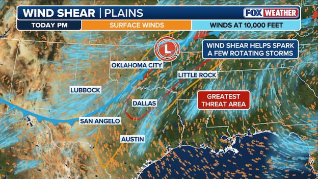
The FOX Forecast Center is closely monitoring an increase in wind shear across the central U.S. as a piece of energy in the atmosphere moves out of the High Plains and toward the Mississippi Valley.
This system is set to collide with a stationary front stretching from Oklahoma to Indiana, creating a corridor where severe thunderstorms are likely to ignite this afternoon and evening.
South of that stationary front, warm and humid air is surging inland from the Gulf of America, with dew points reaching the sticky 60s. This moisture, combined with some afternoon sunshine, will create instability—essentially the fuel that allows storms to grow tall and strong.
FOX Weather meteorologists are particularly watching north-central and central Texas, where the most intense heating could lead to the highest instability levels by late today.
The wind shear—the change in wind speed and direction with height—is strong enough today to help these storms become organized. As storms move across Oklahoma, Kansas, and Missouri, they will have the strength to produce hail that could damage vehicles or property.
As the afternoon heats up, some storms may collapse or form into clusters, sending localized bursts of wind damage toward the ground.
And while the low-level winds aren't exceptionally strong today, there is just enough spin in the atmosphere near the front to support the risk of a tornado or two, especially with any storm that can remain isolated.
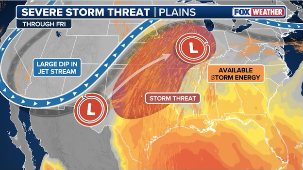
A large dip in the jet stream, surging moisture, and an upper-level disturbance will come together to produce severe storms this week.
Friday’s severe weather threat is being driven by a classic battle of the seasons as a surging plume of springlike warmth and moisture from the Gulf of America collides with a cold Canadian air mass pressing southward.
This collision is expected to anchor a volatile boundary across the central U.S., which forecasters identify as the primary engine for the week’s most dangerous storms.
A powerful jet stream feature is forecast to move over the region by Friday afternoon, providing the necessary wind shear to organize these developing storms into intense supercells.
This setup is particularly concerning because the combination of a robust low-pressure system and high instability creates an environment capable of sustaining long-lived, dangerous weather events.
The primary threat zone for Friday has expanded to encompass a massive corridor stretching from Texas and Oklahoma northward into the lower Missouri Valley and Wisconsin. The Storm Prediction Center has already designated a Level 3 of 5 risk area for parts of the Southern and Central Plains into the mid-Missouri Valley, signaling high confidence in severe storm development.
Residents in states like Oklahoma, Kansas, Missouri, and Texas should remain particularly vigilant, as this region is currently in the bullseye for the most intense activity.
Specific impacts from these storms are expected to be life-threatening and destructive.
Meteorologists are now warning of the potential for tornadoes, some of which could be strong, alongside destructive winds exceeding 70–80 mph and large, damaging hail.
Additionally, a persistent flood threat remains a major concern as repeated rounds of heavy rain target the same areas from Missouri to the Ohio Valley, potentially leading to significant flash flooding.

Spring severe weather season kicks off in earnest this week with tornadoes, damaging winds, and large hail targeting millions of Americans in the Central U.S.
A multi-day severe weather outbreak is unfolding across the central and southern United States, placing more than 80 million Americans under the threat of dangerous storms this week.
As the calendar turns to meteorological spring, a powerful storm system is tapping into warm, humid air from the Gulf of Mexico, fueling an environment primed for volatile weather.
Meteorologists at the FOX Forecast Center are warning that residents from Texas to Wisconsin and as far east as the Ohio Valley should remain on high alert through the weekend as multiple rounds of storms move through the region.
The threat begins in earnest today with a Level 2 of 5 risk area already out for portions of northeast Texas, eastern Oklahoma, southern Missouri, and western Kentucky. While initial morning activity has remained below severe limits, the atmosphere is expected to become increasingly unstable by late afternoon, bringing the risk damaging wind gusts over 60 mph, large hail, and a couple tornadoes.
Major metropolitan areas, including Dallas, Little Rock, and Louisville, are currently in the bullseye for potential severe development as the first wave of this complex system tracks eastward.
Conditions are expected to escalate significantly by Friday, which forecasters are targeting as the most dangerous day this week. The Storm Prediction Center has already issued a Level 3 of 5 risk area for parts of the Southern and Central Plains and the Missouri Valley, where a robust jet stream will likely support the development of rotating supercells. This setup poses a credible threat of intense, long-track tornadoes and destructive straight-line winds.
Additionally, a serious flood threat looms for areas from Missouri to Ohio, as repeated rounds of heavy rain could drop up to four inches of water, leading to localized flash flooding.
While the sun may be trying to peek through in some areas, the FOX Forecast Center is currently tracking scattered thunderstorms pushing across the Central U.S..
Right now, lightning strikes are being detected across several states as this multi-day weather event begins to unfold.
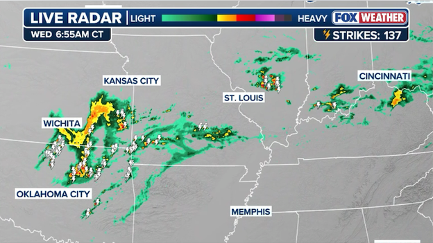
Radar showing a cluster of thunderstorms over Kansas and Oklahoma with more isolated storms in the Ohio Valley.
The latest radar shows storms stretching from the Southern Plains through the Ohio Valley:
- Wichita and Oklahoma City: A line of moderate to heavy rain and embedded thunderstorms is moving through Central Kansas and Northern Oklahoma.
- Cincinnati and Indianapolis: Isolated thunderstorms are moving through the Ohio Valley, marking the start of a damp stretch of weather for the region.
While these morning storms are currently below severe limits, conditions are expected to become more volatile as the day progresses. The Storm Prediction Center has issued a Level 2 of 5 severe storm risk zone for parts of northeast Texas, eastern Oklahoma, southern Missouri, and western Kentucky.
Today's storms will be capable of dropping large hail and whipping up 60+ mph wind gusts later in the afternoon-evening. While a tornado or two cannot be ruled out, conditions are not expected to be favorable for numerous tornadoes.
Flash flooding is also a concern, particularly in areas like Kentucky and Tennessee where storms may train over the same locations.
You’ve reached the beginning of this live coverage.