Live updates: Multiple deaths reported after tornadoes, severe storms strike America's Heartland
Live updates: Multiple deaths reported after tornadoes, severe storms strike America's Heartland
Download the AppAuthorities identify 12-year-old killed in Michigan tornado outbreak
View postCoverage for this event has ended.
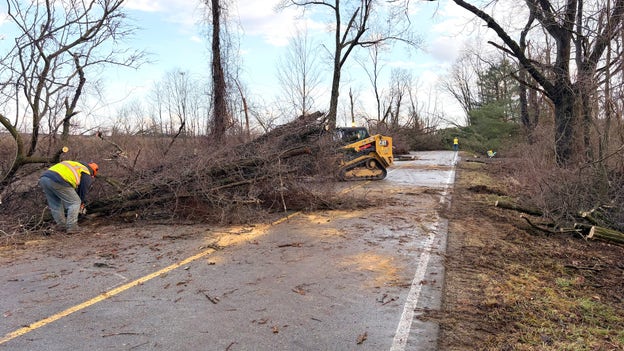
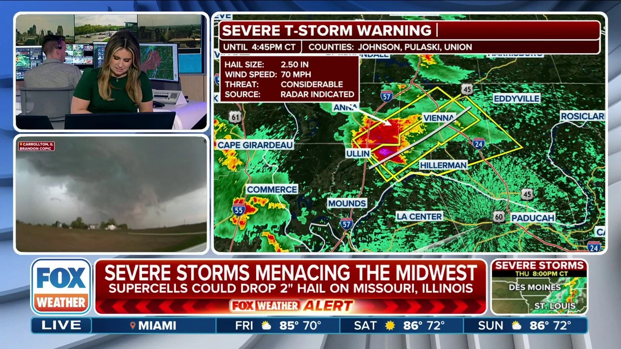
An EF-2 tornado tore through Three Rivers, Michigan, on Friday, leaving a trail of significant damage in its wake. The storm caused structural damage to several local businesses, knocked down power lines and trees, and scattered debris across its path.
Cleanup efforts are underway as crews work to restore power and assess the full extent of the destruction.
In a new damage survey, the National Weather Service announced that the tornado that touched down near Three Rivers, Michigan, on Friday has received a preliminary EF-2 rating.
The powerful storm tore the roofs off several businesses, downed trees and power lines, and sent debris swirling into the air.
The tornado packed estimated wind speeds of 130 mph and injured 10 people as it tore through the popular area in southwestern Michigan.
Initial survey efforts focused on the area near Michigan 60 and West Broadway Street, where numerous commercial structures sustained significant damage, the NWS said.
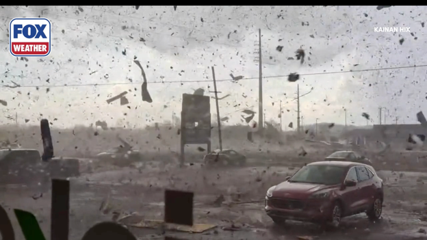
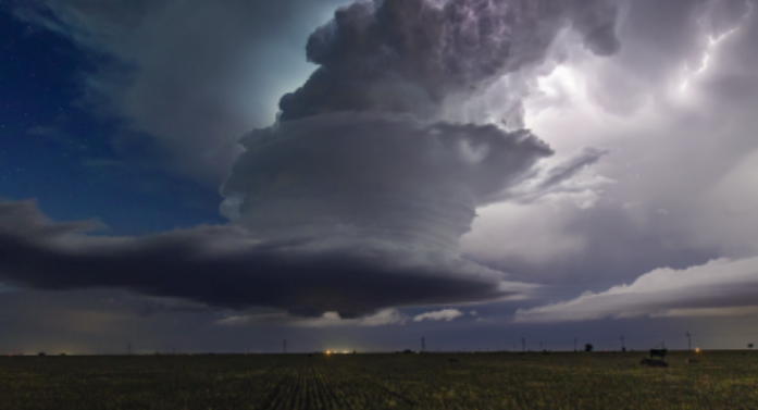
Debris fills the sky as a tornado spins through Three Rivers, Michigan.
Officials noted that only a small portion of the tornado’s potential track has been assessed so far.
As a result, details such as the path length, width, and the tornado’s start and end times are not yet available. Additional information is expected to be released Sunday, March 8, as it becomes available.
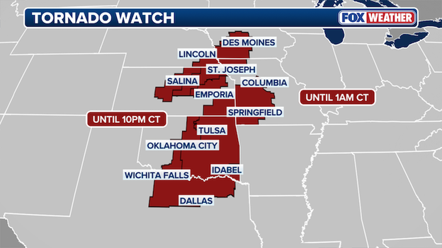
Parts of New York, Ohio, Pennsylvania and West Virginia are under Tornado Watch through 8 p.m. EST tonight.
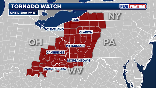
Tornado Watch map
A few tornadoes are possible, isolated ping pong sized hail is possible and wind gusts up to 70 mph are likely.
The tornado watch broadly covers parts of western Pennsylvania, most of northern West Virginia, eastern Ohio and into portions of western New York near Lake Erie
The watch covers over 6.5 million people across the four states as the threat for severe weather remains in Saturday after a marathon, multi-day severe storm outbreak that spawned numerous tornadoes in America's Heartland.
The Cass County Sheriff’s Office has identified a 12-year-old boy as one of the victims killed during Friday’s severe weather in southwest Michigan.
Authorities say the boy, Silas Anderson, was reported missing as severe storms slammed the area and was later found injured; he was taken to a hospital where he later died.
The press release said a possible tornado touched down near Edwardsburg and Conrad Road, part of the broader tornado outbreak that has caused widespread damage and killed 4 in Michigan.
Officials are asking for privacy as the family grieves, and emergency crews continue response and recovery efforts in the area.
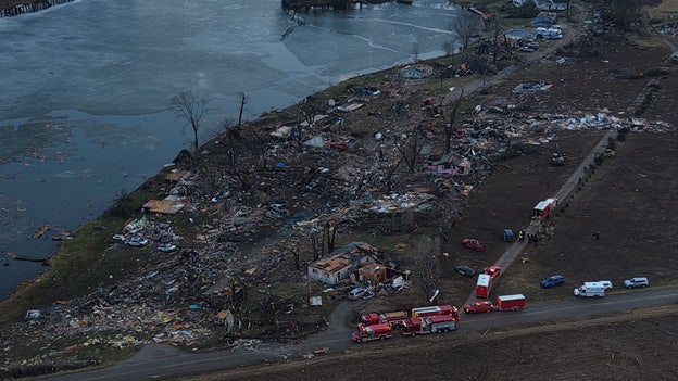
At least eight people are dead after the devastating, multi-day severe weather outbreak swept across the central U.S., spawning multiple dangerous tornadoes, massive hail and damaging winds.
Four of those fatalities were reported in two counties in southwestern Michigan on Friday, where powerful tornadoes tore through Union City.
In Oklahoma on Friday, the Okmulgee County Sheriff’s Office confirmed two deaths after severe storms moved through central parts of the state.
These deadly storms came just hours after a mother and daughter were killed during severe weather in Major County, Oklahoma on Thursday night.
Tornado warnings, damaging wind gusts and large hail are still a dangerous threat as these powerful storms continue to charge into Saturday evening.
A multi-day severe weather outbreak continues across America’s Heartland as the dust begins to settle and extensive cleanup efforts get underway following a deadly, two-day event that spawned multiple tornadoes.
Damage surveys from National Weather Service teams across the central U.S. are now coming in. Here’s a look back at the past two days of severe weather, which have produced at least seven confirmed tornadoes — with the threat still lingering into Saturday.
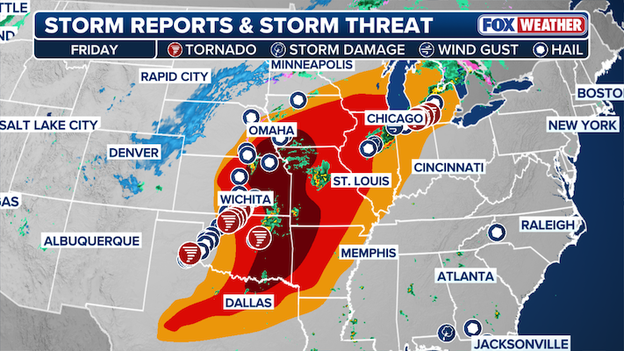
Tornado Map
The multi-day severe weather outbreak began Thursday, when two EF-2 tornadoes tore across parts of Oklahoma.
One tornado touched down near Fairview, packing peak winds estimated between 115 and 120 mph. It carved a 7-mile path through Major County and tragically claimed the lives of a mother and her 13-year-old daughter.
Southwest of Helena, another EF-2 tornado with peak winds estimated between 110 and 115 mph tracked for 19 miles. Fortunately, no critical injuries were reported with that storm.
The National Weather Service in Norman has also confirmed two additional EF-1 tornadoes, while the NWS office in Wichita verified two EF-1 tornadoes from Thursday’s outbreak.
Severe storms developed Friday in what had been designated a Level 1 out of 5 severe weather risk area in Michigan — typically considered a marginal threat.
However, one supercell rapidly intensified, producing a tornado that tore through portions of Cass, St. Joseph and Branch counties.
The National Weather Service has since rated the tornado an EF-3. It killed three people and injured 12 others.
According to the FOX Forecast Center, it is the strongest March tornado to strike Michigan in nearly 16 years.

Damage surveys are continuing across the hardest-hit areas from this devastating, multi-day tornado outbreak, and new information is expected throughout the day.
But the threat is not over.
Additional strong to severe storms are still possible, and millions remain at risk as this active weather pattern continues. Stay with FOX Weather as we track new developments on the ground and monitor storms in real time.
The National Weather Service announced Saturday that the powerful tornado that tore through Union City, Michigan, has been rated an EF-3.
The tornado was spawned by a supercell thunderstorm that caused damage across portions of Cass, St. Joseph and Branch counties. The storm system produced the deadly tornado that killed three people and injured 12 others.
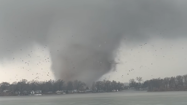
The devastating tornado caught on camera in Union City, Michigan has been rated an EF-3 in a preliminary damage assessment. Photo Courtesy: Lisa Nicola
Preliminary estimates indicate winds reached at least 150 mph, destroying several homes near Tuttle Road and Prairie Rose Lane.
An NWS damage survey remains underway in the areas of Union Lake and Union City. Officials say damage and ongoing operations are limiting access to some locations.
“Only a small portion of the possible track has been assessed, so no path length data or start and end times are available yet,” the damage report stated.
The National Weather Service said additional details will be released as they become available.
The Tulsa County Sheriff’s Office shared photos showing significant tornado damage at the Tulsa Tech Peoria campus after a tornado swept through the area.
Tulsa Mayor Monroe Nichols toured parts of North Tulsa Friday evening and said there were no reported injuries in the city as of 9 p.m.
The Sheriff’s Office reported large amounts of glass and debris scattered across the campus. Cleanup efforts are underway, and deputies will maintain full-time security at the site until further notice.
Officials are asking the public to avoid the area while remediation crews work to secure the campus and make it safe.
The first major severe weather outbreak of 2026 has left a devastating footprint across the American heartland. What began as a volatile clash between warm Gulf air and a cold northern front escalated into a multi-state emergency on Friday, claiming at least eight lives since Thursday and leaving over 100,000 people in the dark.
The storm system’s most lethal impact was felt in Michigan and Oklahoma. In Southern Michigan—a region where early-March tornadoes are historically rare—the Branch County Sheriff’s Office confirmed three fatalities in the Union Lake area alone. A fourth death was reported in neighboring Cass County, where homes and agricultural buildings were reduced to debris.
More than 100 reports of severe weather have come in since Thursday.
In Oklahoma, the violence of the storm was equally apparent. Two people were killed in the town of Beggs, south of Tulsa, when a tornado struck their home. These fatalities underscore the dangerous nature of this event, which FOX Weather meteorologists warned could produce long-track, intense tornadoes.
The FOX Forecast Center says more than 100 reports of severe weather have come in across a dozen states since the storm began its deadly rampage on Thursday.
Survey teams from the National Weather Service will be out today, assessing the damage to determine the strength of Friday's tornadoes.

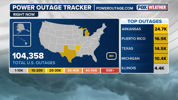
PowerOutage.com outage tracker shows more than 100,000 U.S. customers are without power right now.
Following a night of violent weather, more than 100,000 customers remain without power this morning as utility crews scramble to repair widespread infrastructure damage caused by tornadoes and damaging winds.
At least eight people are dead after a devastating, multi-day severe weather outbreak swept across the central U.S., spawning multiple dangerous tornadoes, massive hail and damaging winds.
Four of those fatalities were reported in two counties in southwestern Michigan on Friday, where powerful tornadoes tore through Union City.

Union City, Michigan devastation. Credit: 517Drone Video and Photograph
In Oklahoma on Friday, the Okmulgee County Sheriff’s Office confirmed two deaths after severe storms moved through central parts of the state.
These deadly storms came just hours after a mother and daughter were killed during severe weather in Major County, Oklahoma on Thursday night.
Tornado warnings, damaging wind gusts and large hail are still a dangerous threat as these powerful storms continue to charge across the region.
Severe storms are on the move this morning with more than 100 million Americans at risk for tornadoes, damaging winds, and large hail today.
This graphic from the FOX Forecast Center shows the vast stretch of severe storms impacting America today.
Today’s risk area includes Pittsburgh and Cleveland all the way down to Dallas, San Antonio, and Houston.

Union City, Michigan Church damage. Credit: Kristen Rieder
See more photos by clicking here.
At least six people are dead after a devastating severe weather outbreak swept across the central U.S., spawning multiple dangerous tornadoes, massive hail and damaging winds.
Four of those fatalities were reported in two counties in southwestern Michigan, where powerful tornadoes tore through Union City.
Courtesy: 517Drone Video and Photograph. Location: Union City, Michigan
In Oklahoma, the Okmulgee County Sheriff’s Office confirmed two deaths after severe storms moved through central parts of the state.
As we head deeper into the night, the severe weather threat is far from over.
Tornado warnings, damaging wind gusts and large hail remain possible as these powerful storms continue to track across the region. Even after the sun goes down, conditions can still change rapidly — and nighttime storms can be especially dangerous.
The FOX Weather team will continue monitoring radar, warnings and developments as storms move through the region. We’ll provide updates, reports from the field and important safety information as it becomes available.
The Okmulgee County Sheriff’s Office confirmed two deaths Friday after severe storms tore through parts of Oklahoma.
Authorities have not yet released additional details about the circumstances surrounding the fatalities.
Stay with FOX Weather for continuing coverage of this deadly severe weather outbreak.
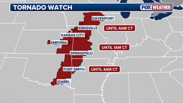
Tornado watches have expired for several areas across the central U.S., but new watches have been issued elsewhere as the severe weather threat continues into Saturday morning.
Kansas City, MO, Davenport, IA, and Fort Smith, AR are all under Tornado Watch.
Tornado Watch Map
Portions of Oklahoma through Iowa remain under a Tornado Watch overnight, where tornadoes are still possible as storms track across the region.
In addition to the tornado risk, these storms could produce hail up to 2 inches in diameter and damaging wind gusts of up to 70 mph.
After a tornado touched down near Tulsa, Mayor Monroe Nichols announced that there are no injuries reported in the City at this time.

No injuries reported after a tornado moved through North Tulsa
"Took a preliminary tour of some of the damage tonight in North Tulsa after a tornado moved through the area and caused localized impacts. While we’re grateful there are no reports of injuries in Tulsa at this time, our thoughts are with those across Northeast Oklahoma who experienced more severe impacts from tonight’s storms," Mayor Nichols said in a Facebook post.
Scattered damage has been reported across parts of North Tulsa, including roof damage, downed trees, and multiple downed power lines.
More than 6,000 customers are without power in Tulsa County, with some outages linked to downed lines.
Emergency response teams are actively surveying impacted areas and addressing immediate safety concerns, focusing on areas near 36th and 46th Street North, Lewis Avenue, and Peoria Avenue. Officials are coordinating with local emergency management partners as crews monitor roadways and infrastructure.
A dangerous severe weather outbreak sweeping across Oklahoma today is leaving a growing number of residents in the dark, with widespread power outages reported across central and northeastern parts of the state.
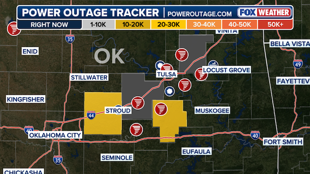
Power Outage Tracker using data from poweroutage.com.
According to the latest data from PowerOutage.com, multiple counties are experiencing significant service disruptions as powerful thunderstorms move through the region.
As storms continue to move through the region, outage numbers could fluctuate. Residents are encouraged to monitor local alerts and prepare for the possibility of extended power interruptions.
Stay with FOX Weather for the latest updates on this developing situation.
Dangerous tornadoes ripped through Southwestern Michigan earlier, where four people were killed as powerful storms tore through multiple counties and continue threatening millions across the central U.S.
In Cass County, officials confirmed one fatality after a tornado ripped through areas near Edwardsburg on Friday afternoon.
Emergency crews were deployed to the southern portion of the county as the storm carved a destructive path beginning just west of Edwardsburg along Conrad Road and continuing east past M-62, according to the Sheriff’s Office.

Courtesy: 517Drone Video and Photograph. Location: Union City, Michigan
Cass County Emergency Management reported widespread devastation. Multiple large structures — including homes and pole barns — sustained significant damage, with some suffering major structural impacts and others completely destroyed.
Numerous trees were toppled onto homes and roadways, creating dangerous conditions and hampering emergency response. More than 500 customers lost power, according to Midwest Energy & Communications. Several injuries were also reported, Sheriff Clint Roach said.
As the scope of the destruction became clear, Cass County Board Chair Jeremiah Jones issued a local state of emergency, noting that local resources were stretched to their fullest extent and additional assistance may be needed.
Farther east in Branch County, the toll was even more devastating. The Branch County Sheriff’s Office confirmed that three people were killed after a strong, dangerous tornado tore through the Union Lake area. Emergency crews remain on scene assessing damage and clearing debris as recovery efforts continue.
Sheriff Frederick A. Blankenship urged residents to avoid the hardest-hit areas to allow first responders to safely conduct search-and-recovery operations. “Our thoughts are with those who have lost family, friends, and property during this incident,” the Sheriff’s Office said in a statement, adding that further updates will be provided as more information becomes available.
The deadly tornadoes were part of a broader severe weather outbreak that continues through the evening and into Saturday, with millions across the Midwest and central U.S. bracing for the threat of additional tornadoes, large hail and damaging winds.
Forecasters warn that conditions remain favorable for dangerous storms, and residents in impacted areas should stay weather-aware, monitor alerts closely and be prepared to seek sturdy shelter immediately if warnings are issued.
One death has been reported in Cass County after a tornado tore through the southwestern Michigan county, officials announced in a press release.
Emergency personnel has been deployed in the southern portion of Cass County after a tornado touched down near Edwardsburg this afternoon.
Cass County Emergency Management reports that multiple large structures — including homes and pole barns — have sustained significant damage, with some suffering major structural impacts and others completely destroyed.
Cass County emergency personnel are working to clear debris and provide support to those affected by a tornado that touched down near Edwardsburg on Friday.
Several injuries have been sustained in Cass County, Sheriff Clint Roach reported, and one fatality has been confirmed.
Numerous trees have fallen onto roads and buildings, and more than 500 customers are currently without power, according to reports from Midwest Energy & Communications (MEC).
Preliminary damage reports indicate damage began just west of Edwardsburg along Conrad Road and continued east past M-62, the Sheriff's Office announced in a press release.
Cass County Board Chair Jeremiah Jones issued a local state of emergency Friday evening, noting that local resources are being utilized to their fullest extent and that additional assistance may be required to clear debris and support affected residents.
Areas across the Southern Plains and Midwest remain under Tornado Watches into the evening, as a significant severe storm system threatens millions across the central US.
Forecasters warn that storms developing across the region could produce tornadoes, large hail and damaging wind gusts tonight and into Saturday.
Tornado Watch Map
Residents in impacted communities should remain weather-aware, keep multiple ways to receive warnings and be prepared to seek sturdy shelter immediately if a Tornado Warning is issued.
Stay with FOX Weather through the night for real-time forecasts and critical updates as severe storms continue to batter the region.
After experiencing numerous tornadoes earlier this afternoon, communities in Southwestern Michigan are now seeing a line of thunderstorms move through the area.
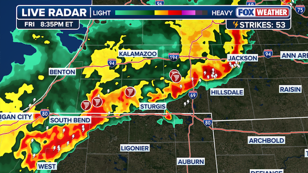
Live Radar as of 8:35 p.m. EST
The Branch County Sheriff's Office announced that there deaths and dozens of injuries have been reported as recovery and clean up operations are ongoing.
The Branch County Sheriff's Office announced that as of 8 p.m., three deaths have been reported after a strong, dangerous tornado ripped through the Union Lake area in Southwestern Michigan today
Sheriff Frederick A. Blankenship is urging residents to avoid the affected areas to allow emergency personnel to safely conduct response and recovery operations from the area that was battered by severe weather today.

Tornado damage in Union City, Michigan
Emergency crews remain on the scene, assessing damage and working to clear affected areas as severe weather continues to impact the region.
"Our thoughts are with those who have lost family, friends, and property during this incident," the Sheriff's Office said in a press release.
A press release announced that further updates will be provided as additional information becomes available.
A Confirmed Tornado Warning was reported just three miles North of Tulsa, Oklahoma, a city home to more than 400,000 people.
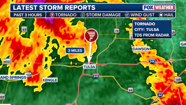
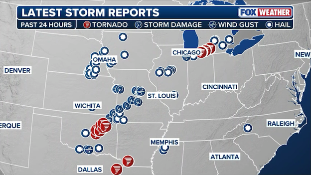
Latest Storm Reports
The tornadic debris signature was identified on radar amid a dangerous severe weather outbreak threatening millions across the region.
Stick with FOX Weather as we continue to monitor the widespread severe weather outbreak.
A radar-confirmed tornado touched down near Tulsa County, Oklahoma.
Confirmed Tornado in Oklahoma
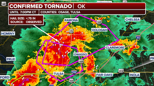
The national weather service in Tulsa has issued a Tornado Warning for. Northwestern Rogers County, Southeastern Osage County, Southern Washington County and Northeastern Tulsa County until 730 pm CST.
The NWS said at 634 pm CST, a confirmed tornado was located over Turley, moving northeast at 30 mph.
Locations in or near the path include Skiatook, Turley, Ramona, Vera, Oologah, Collinsville, Sperry, Owasso and Tulsa.
A Tornado Watch has been issued for parts of southeast Kansas and southwestern Missouri until 1 A.M. CST, as more than 15 million Americans are under Severe Weather Alerts.
Tornado Watch map
Across the Central US, a vast stretch spanning multiple states has millions of people under threat of tornadoes through Friday evening, with the potential for dangerous twisters, large hail, and damaging winds.
Across the Heartland, residents in areas under alert should remain weather-aware as the threat of severe storms continues tonight into Saturday morning. Stay with FOX Weather as we track the latest developments across the region.
A mother and her 13-year-old daughter were tragically killed when a powerful nighttime tornado swept through Oklahoma on Thursday.
Jodie Owens and her daughter, Lexi Owens, lost their lives in the devastating severe storm, leaving their family and community heartbroken. Jacob Zonts, Jodie’s brother and Lexi’s uncle, joined FOX Weather to honor their memories and speak about the profound loss his family is enduring during this incredibly difficult time.
The severe weather threat is decreasing around Dallas as a "cap" has stayed in place, putting a lid on the atmosphere.
Right now, that lid has stayed in place around Dallas, preventing storms from developing.
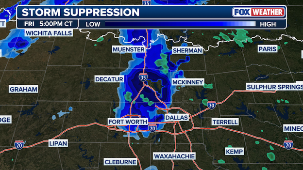
'Cap' suppresses storm potential near Dallas, Texas
Because of that, even though the area is still under a Tornado Watch, the chances of severe storms are going down.
According to the FOX Forecast Center, there could still be an isolated storm or two popping up through about 10 p.m., but widespread severe weather in the area is unlikely.

Several tornadoes have already touched down in Michigan, kicking off what is shaping up to be a dangerous severe weather Friday for millions across the Central U.S., from the Southern Plains into the Upper Midwest.
These tornadoes developed in what was only a Level 1 of 5 severe risk area in southwestern Michigan— catching many off guard and underscoring an important message: even on lower-risk days, the tornado threat is never zero.
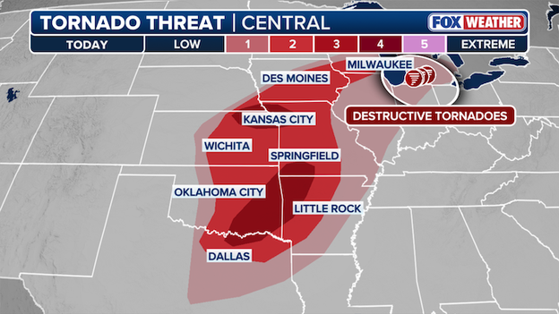
Tornado threat across the Central U.S.
Now, as we head into the evening hours, the atmosphere remains primed for additional storms capable of producing tornadoes, damaging winds, and large hail.
The greatest threat sits in a level 3/5 risk area in parts of Texas, Arkansas, Oklahoma and Missouri.
Millions are at risk across the Central U.S. of dangerous severe weather through tonight into Saturday morning, so if you are in the risk area, stay alert and be ready to act quickly if warnings are issued.
Stay with FOX Weather as we track dangerous severe storms and the ongoing tornado threat through the night.
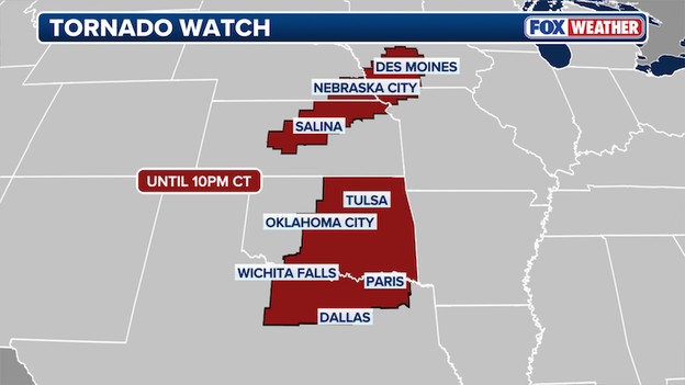
A Tornado Watch has been issued in parts of Iowa, Kansas, Missouri and Nebraska as the Central U.S. braces for an evening of dangerous severe weather.

Tornado Watch Map in effect until 10 p.m. CST
Strong tornadoes are possible, scattered hail up to 2" is likely and wind gusts up to 70 mph are possible.
The Tornado Watch is in place until 10 p.m. CST. Parts of Oklahoma and Texas are also under Tornado Watch, including Dallas and Oklahoma City.
Over 13 million are under Tornado Watch across Central U.S.
Stay with FOX Weather for nonstop coverage as dangerous severe storms sweep across the U.S. through the night.
Damage reports are pouring in from southwestern Michigan after a confirmed tornado touched down in St. Joseph County.
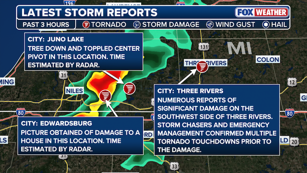
Latest Storm Reports in southwestern Michigan
In Juno Lake, a tree was knocked down and a center pivot irrigation system was toppled. In Edwardsburg, photos show clear damage to a home.
Significant damage has also been reported on the southwest side of Three Rivers, where Storm chasers and emergency management officials confirmed multiple tornado touchdowns in the area before the damage reports began to come in.
A particularly dangerous situation is unfolding near Three Rivers, Michigan as a radar indicated, damaging tornado swirls east in southwestern Michigan.
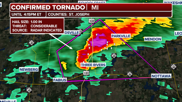
Confirmed Tornado in St. Joseph County, Michigan
At 352 p.m. EST, a "large and extremely dangerous tornado" was located over Three Rivers, moving northeast at 40 mph, the National Weather Service said.
Other locations impacted by this tornadic thunderstorm include Moore Park, Fishers Lake, Nottawa, And Wasepi.
A Tornado Watch has been issued for parts of Oklahoma and Texas until 10 p.m. CST tonight.
Strong tornadoes are possible, tennis ball sized hail 2.5" in diameter and scattered wind gusts up to 70 mph are possible.
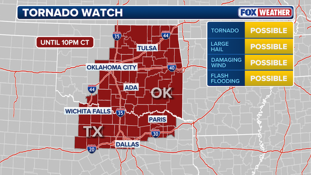
Tornado Watch issued for parts of Texas and Oklahoma
Dallas and Oklahoma City are included in the watch that has over 11 million people across the two southern states under threat.
In a new outlook, the Storm Prediction Center has increased the tornado threat in parts of Kansas, Missouri and Nebraska.

Tornado Threat increases in parts of Kansas, Missouri and Nebraska
While the overall forecast hasn’t shifted much, one key change stands out.
A Level 3/5 tornado threat is now in place for covering an area in the three Central U.S. states, including Topeka and Kansas City.
Tornado potential is increasing this evening near the surface low and warm front across far southeastern Nebraska, northeast Kansas and northwest Missouri. With conditions becoming more favorable, forecasters have raised tornado probabilities.
Missouri Governor Mike Kehoe has declared a State of Emergency in preparation for potentially dangerous severe weather forecasted across the state.
“The National Weather Service has cautioned that the threat of severe storms throughout the state tonight may produce damaging winds, large hail, and tornadoes,” said Governor Kehoe.
“I urge all Missourians to pay attention to their local weather forecasts, follow official warnings, and have multiple ways to receive alerts – especially overnight.”
Under the order declaring a State of Emergency, the Missouri State Emergency Operations Plan has been activated, which enables state agencies to coordinate directly with local jurisdictions to expedite assistance.
When meteorologists talk about a "conditional" threat, they are essentially saying the atmosphere is like a loaded gun—it has all the energy it needs to be dangerous, but it still needs a trigger to pull.
Today is a perfect example of this. We have record-breaking heat and high humidity acting as fuel, but a strong cap of warm air about a mile up is currently acting like a lid on a boiling pot, preventing storms from firing off.
If supercell thunderstorms can develop today, they'll have the potential to spin up strong (EF-2+) tornadoes across a huge swath of the central U.S.
Here is what that "conditional" setup means for you today:
The "all-or-nothing" scenario: If that atmospheric lid stays on tight, we might see very little activity. However, if the lid is removed by intense afternoon heating or an approaching cold front, the pent-up energy will be released all at once.
High impact, low coverage: Because the threat is conditional, we might only see one or two storms develop. The catch is that any storm that does manage to break through will likely turn violent immediately, tapping into a dangerous environment capable of producing intense tornadoes or extremely large hail.
To help show this, the Storm Prediction Center just launched a new feature in its everyday outlook this week called Conditional Intensity Group. It tells us that even if the chance of a storm hitting your backyard is low, the intensity could be extreme if it actually happens.
Forecasters are using new levels to describe this potential: CIG 2 signals a dangerous environment for intense tornadoes (EF3+) or giant hail, while Level 3 is reserved for rare, historic-level outbreaks.
Thunderstorms have prompted the Federal Aviation Administration to issue a ground stop for Hartsfield-Jackson Atlanta International Airport (ATL), the nation's busiest aviation hub.
This specific order is currently impacting nearby regional airports only, with the hold on departures destined for Atlanta scheduled to remain in effect until 2:45 PM ET.
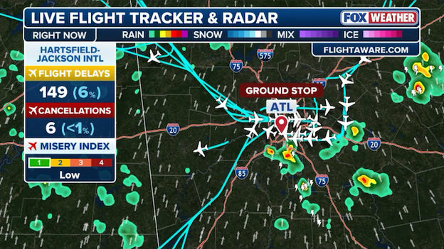
A ground stop has been ordered for Atlanta's Hartsfield-Jackson International Airport.
Travelers should expect a significant ripple effect as this world-class hub deals with the weather.
While the ground stop is currently localized to the closest surrounding airports, history shows that even a brief pause at ATL can quickly lead to cascading delays across the entire Southeast and beyond.
If you are flying into or out of Atlanta this afternoon, check your airline's app immediately for the latest updates on your flight's status.
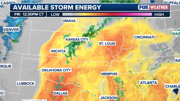
Analysis shows instability is rapidly increasing across the central U.S. ahead of an approaching storm system.
Atmospheric instability is rapidly climbing across the Heartland right now as record-breaking heat and moisture surge northward, setting the stage for a dangerous afternoon of severe weather.
With temperatures soaring into the 70s and 80s—roughly 20 to 30 degrees above average—the environment is becoming high-octane fuel for explosive storm development.
The FOX Forecast Center is specifically watching a Level 3 of 5 risk zone covering central Oklahoma, eastern Kansas, and western Missouri, where this unstable air is expected to trigger numerous severe storms as a cold front moves in.
Recent rains have trigged significant river flooding in the Ohio Valley.
Major flooding along the East Fork White River in Indiana is reaching a critical point as water levels in some areas are expected to crest at near-record heights today.
While these major flood levels are forecast to begin receding to moderate stages by this afternoon, widespread minor-to-moderate flooding will persist across the region through at least mid-next week.
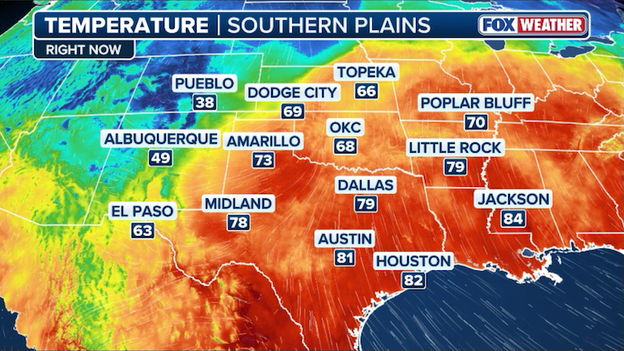
Record warm air is surging north right now, fueling today's severe weather outbreak.
Spring is arriving with a vengeance today as a surge of record-breaking heat provides the high-octane fuel for a severe weather outbreak across the heartland.
Temperatures are forecast to soar into the 70s and 80s across the Plains and Midwest, with some areas seeing readings 20 to 30 degrees above seasonal averages.
This unseasonable warmth is being pulled north by a strengthening storm system, creating a volatile clash of seasons as it meets cooler Canadian air.
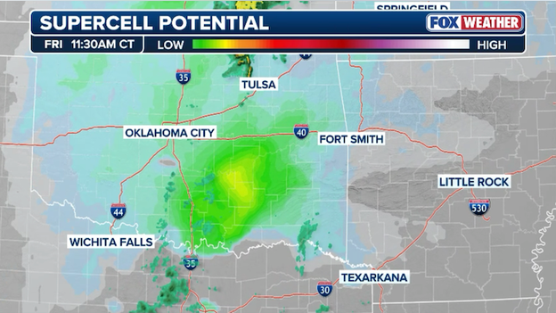
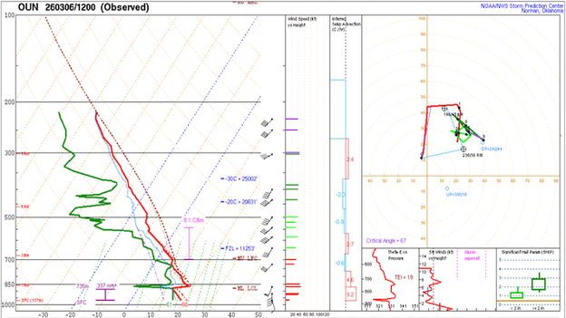
Supercell Composite Parameter shows conditions are becoming more favorable for "supercells" in Oklahoma this afternoon.
The FOX Forecast Center says conditions are becoming more favorable for supercell thunderstorms to develop across the Plains this afternoon.
Right now, the Supercell Composite Parameter, a specific metric that indicates the necessary ingredients for rotating, long-lived thunderstorms—including moisture, instability, and wind shear—is increasing ahead of an approaching storm system in Oklahoma.
If you live in the region, keep a close eye on the horizon, as these conditions are becoming increasingly favorable for the development of discrete cells capable of producing both destructive hail and tornadoes.
The National Weather Service in Norman has confirmed that at least three tornadoes hit western Oklahoma during Thursday night's severe weather.
Survey teams are currently on the ground in several areas, including Major, Alfalfa, and Grant Counties, to finalize these counts and determine the official intensity ratings for each twister.
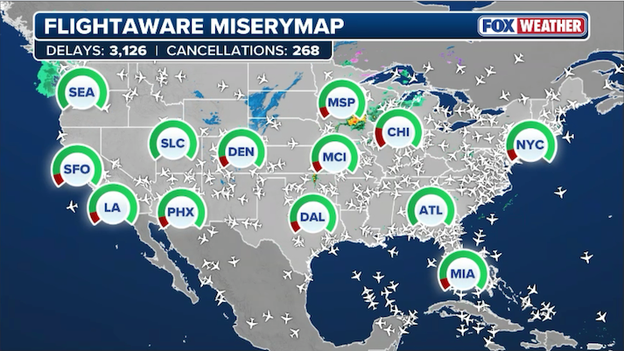
FlightAware MiseryMap showing flight disruptions at major hubs across America.
A massive wave of flight disruptions is rippling across the national aviation network today as severe weather hammers the country’s most critical hubs, resulting in over 3,100 total disruptions across the U.S. with Chicago serving as the epicenter of the chaos.
Chicago O'Hare International Airport and Midway International have recorded at least 830 disruptions, including over 715 delays and 115 cancellations.
Because Chicago is a primary connecting hub, these delays have triggered a massive ripple effect that has scrubbed short-haul feeder flights from cities like Des Moines and St. Louis and even severed international routes to London, Paris, and Doha.
Severe thunderstorms are forecast to erupt from the Great Lakes to Texas this afternoon-evening.
The atmosphere is loading the bases this afternoon, and we are tracking a high-stakes weather setup from the Plains to the Great Lakes. If you’re looking at the radar and seeing early rain in Oklahoma and Kansas, don't let that fool you—that's just the warm-up act.
The FOX Forecast Center is watching low-level moisture (the muggy air you can feel) streaming north, which is acting like high-octane fuel for the storms expected to ignite later today.
Here is the breakdown of what we are watching at this hour:
Afternoon ignition
By mid-afternoon, we expect individual, powerful storms called supercells to fire up across Nebraska, Kansas, and Oklahoma. Think of these as the solo performers of the storm world—they are dangerous because they rotate and can stay active for hours.
These storms will bring a major risk for very large hail. We are also watching the low-level jet, a stream of fast-moving air just above the ground that will strengthen after sunset. This adds twist to the atmosphere, meaning any storm that stays individual could produce a strong tornado.

The evening shift
As we head into tonight, those individual supercells will likely clump together into bowing clusters. When you hear meteorologists talk about upscale growth, they just mean the storms are joining forces to form a solid line.
While this sometimes lowers the tornado threat slightly, it trades it for a damaging wind threat. This line of storms is expected to plow through Iowa and Missouri this evening and could hold its strength as it pushes toward Illinois and Wisconsin overnight.
Today's 'wild card' in the South
Down in Oklahoma and Texas, there’s a bit of a "wait and see" game with the dryline—the boundary where dry desert air meets moist Gulf air. If storms can break through the cap (that lid of warm air aloft), they will have massive amounts of energy to work with.
Whether it's a lone supercell this afternoon or a fast-moving cold front tonight, the message is the same: have your FOX Weather app alerts turned up loud, especially since some of this action will be rolling through while you're asleep.
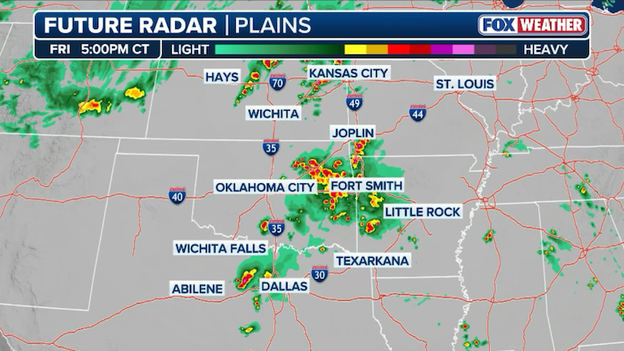
Future radar showing the timing of storms developing across the Heartland later today.
Today’s severe weather threat is expected to rapidly intensify this afternoon as a powerful storm system sweeps across the Plains and into the Midwest.
Future Radar shows that by 5:00 p.m. CT, thunderstorms will be firing from north of Kansas City down through Oklahoma and into north Texas.
Major hubs like Oklahoma City, Fort Smith, and Dallas are in the immediate path of these storms, which are forecast to bring a dangerous combination of very large hail, damaging wind gusts, and tornadoes.
This afternoon timing is particularly critical as it coincides with the evening commute, meaning residents in the path of these storms should have a plan in place and a way to receive alerts before the most intense weather arrives.
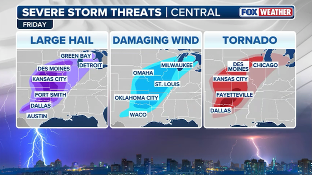
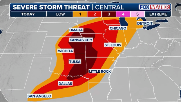
Tornadoes, damaging winds, and large hail are all expected across a 1,500-mile stretch of the central U.S. today.
A severe weather outbreak is targeting the nation's midsection today, bringing a triple threat of large hail, damaging winds, and tornadoes to millions of residents.
Forecasters say a massive corridor of concern stretches from the Texas Hill Country all the way to the Great Lakes, with the most intense activity expected this afternoon and evening.
For those in the path of these storms, here is the breakdown of today's primary threats:
- Large hail: A significant risk for destructive hail covers a broad area from Austin and Dallas up through Kansas City and Des Moines, extending as far northeast as Green Bay and Detroit.
- Damaging winds: Potentially life-threatening wind gusts are forecast for a central slice of the country, impacting major hubs including Oklahoma City, Omaha, St. Louis, and Milwaukee.
- Tornadoes: The threat for tornadoes is particularly concerning today, with the bullseye centered over the Ozarks and Mid-Mississippi Valley, including cities like Fayetteville, Kansas City, Des Moines, and Chicago.
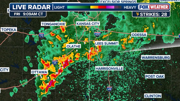
Radar image showing thunderstorms moving into the Kansas City metro area right now.
Scattered thunderstorms are moving into the Kansas City area this morning as a powerful storm system begins to take hold of the region.
While this initial round is mainly producing heavy rain and small hail, it is setting the stage for a much more significant severe weather threat later this afternoon and evening.
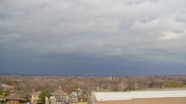
Darkening skies over Guthrie, Oklahoma as strong storms approach.
A camera in Guthrie, Oklahoma, shows darkening skies this morning as the first wave of strong storms begins to push into the region.
These low-hanging, ominous clouds provide a clear view of the atmospheric moisture currently building across the heartland ahead of this afternoon's primary severe weather threat.
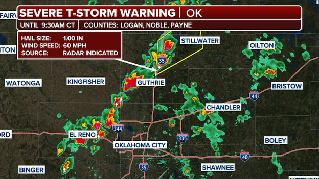
Radar showing a Severe Thunderstorm Warning north of Oklahoma City right now.
A first round of strong thunderstorms is already developing north of Oklahoma City this morning, pushing through areas including Stillwater and Guthrie.
While these morning storms are mostly "elevated," meaning they are primarily a threat for small hail and downpours, they are a sign of the increasing moisture and instability in the region.
This early activity is just a precursor to a much more dangerous round of storms expected to ignite this afternoon as the atmosphere fully primes itself for a severe storm outbreak.
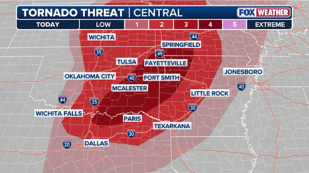
Tornadoes are most likely to develop across eastern Oklahoma, southern Missouri, and western Arkansas later today.
While a massive 1,500-mile stretch of the heartland is on alert today, the most serious bullseye for tornado activity is zeroing in on a corridor from eastern Oklahoma and Kansas up through Nebraska, western Missouri, and southern Iowa.
The FOX Forecast Center is particularly concerned about the evening hours as a powerful low-level jet of wind begins to crank up over the Plains. This surge of energy provides the atmospheric spin needed to turn individual thunderstorms into intense, rotating supercells.
Any storm that stays on its own during this window will have the potential to produce a strong tornado, especially as these storms move along and south of a warm front draped across the Midwest.
Farther south into the Ozarks and western Arkansas, the situation is a bit more of a wild card but remains equally dangerous. While there is some uncertainty about exactly how many storms will fire up along the dryline in Oklahoma and Texas this afternoon, any storm that manages to break through the atmospheric cap will have plenty of fuel to work with.
If these storms can take hold, they will pose a threat for all hazards—including the potential for strong tornadoes and very large hail.
Because the risk is expected to persist after sunset and even into the overnight hours as the storms form into a fast-moving line, it is critical to download the FOX Weather App now and enable critical life-saving weather alerts.
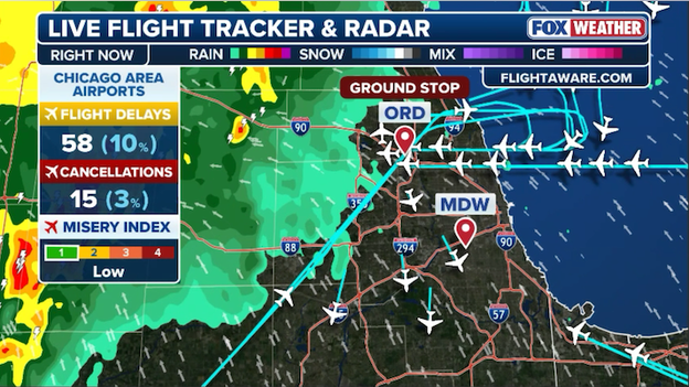
A ground stop is in effect for Chicago O'Hare until 10:30 a.m. ET.
The Federal Aviation Administration has issued a ground stop for Chicago O’Hare International Airport this morning as a line of strong storms and dense fog move through the region.
The ground stop is currently in effect until 10:30 a.m. ET, causing significant delays for travelers heading into one of the nation’s busiest aviation hubs.
Heavy rain and low visibility have already led to more than 1,200 flight disruptions today across the U.S., with both O’Hare and Midway facing operational challenges during the peak morning travel window.
While this initial round of weather is causing immediate travel headaches, it is also setting the stage for a more volatile atmosphere later this afternoon. Once the morning rain clears, a second, stronger line of storms is expected to target the Chicago metro area tonight, bringing a renewed risk of damaging winds and isolated tornadoes.
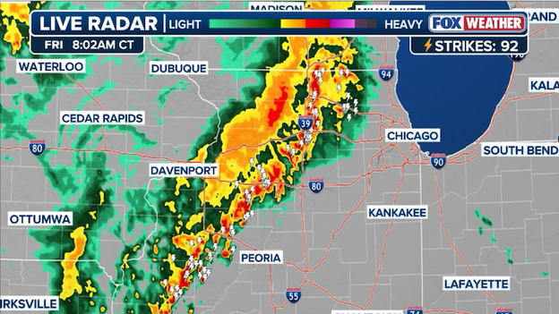
Radar image showing a line of strong storms roaring into Chicago this morning.
A line of strong storms is tracking toward the Chicago metro area this morning, marking the first of two expected rounds of active weather for the region today.
These initial storms are moving through a soup of dense fog that has already caused travel disruptions at O'Hare and Midway airports.
While this morning's activity is primarily a threat for heavy rain and localized flooding, forecasters warn that any embedded cells could produce small hail and gusty winds as they push through the city and surrounding suburbs.
The morning rain is expected to clear out by the early afternoon, allowing temperatures to climb into the 60s and 70s—potentially nearing record highs for early March.
This surge of warmth will further prime the atmosphere for a second, more potent round of weather late tonight into early Saturday morning.
Residents should remain weather aware throughout the day, as the FOX Forecast Center indicates that the overnight line of storms will carry a higher risk for damaging wind gusts up to 50 mph and the isolated possibility of a tornado.
FOX Weather meteorologists are closely watching a crucial atmospheric feature today known as a "cap," which is currently acting as an invisible lid over the heartland and preventing storms from firing off early.
This cap is essentially a layer of warm air sitting a few thousand feet above the ground that stops rising air parcels in their tracks, effectively bottling up the day's growing heat and humidity.
While this keeps the radar clear for now, it is also allowing a massive amount of energy to build up near the surface, much like pressure inside a shaken soda bottle.
Atmospheric sounding showing a 'cap' in place over Oklahoma City this morning.
The danger comes later this afternoon and evening when the cap is expected to break due to intense daytime heating and an approaching weather disturbance.
When that lid finally lifts or weakens, the pent-up energy is released all at once, often resulting in explosive storm development.
This is why storms that fire after a strong cap breaks are frequently more violent, as they have a full day's worth of fuel to tap into instantly.
Residents in the path of today's threat should not be fooled by the calm morning skies; the late-day arrival of these storms will be rapid and powerful once that atmospheric lid is removed.
Forecasters at the Storm Prediction Center have expanded today’s Level 3 of 5 threat area further into northeast Kansas, southeast Nebraska, and southwest Iowa as the threat of destructive hail grows.
This shift comes as meteorologists track a volatile setup where individual supercells are expected to ignite this afternoon along a warm front moving through the region.
Severe thunderstorms are expected to erupt across the central U.S. later this afternoon.
These initial storms are the primary concern for residents, as they pack the potential to drop stones larger than three inches in diameter—roughly the size of an apple—which can easily shatter windshields and damage roofs.
While the hail threat is the early headline, the danger will transition toward a tornado risk as the sun goes down.
A strengthening low-level jet stream after sunset will provide the twist in the atmosphere needed to turn these supercells into tornado producers, and FOX Weather meteorologists warn that a few strong tornadoes are possible.
As the night progresses, these individual storms will likely cluster together into a fast-moving line of wind.
Governor Kevin Stitt confirmed Friday morning that two people were killed during severe weather in Major County on Thursday night.
State officials identified the victims as a mother and daughter who were caught in the path of the storm. Emergency responders across northern Oklahoma reported significant damage following the storms, including destroyed homes and downed power lines that left thousands without electricity.
State officials are currently assessing the destruction in the affected areas as families begin the recovery process. Governor Stitt issued a statement expressing his condolences to the grieving family and to all residents impacted by the storm.
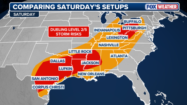
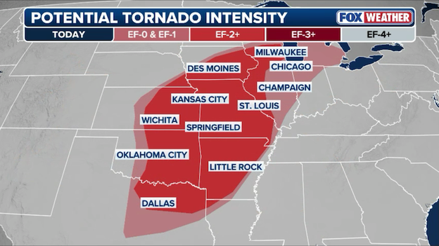
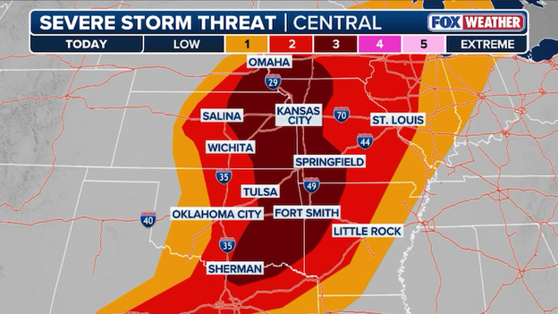
Yesterday’s storms were just the opening act. Ten states are bracing for impact as a massive 1,500-mile stretch of the heartland faces a destructive hail threat through this evening.
We’re talking a high-stakes zone for over 68 million people—including major hubs like Dallas, Oklahoma City, Kansas City, and Chicago—where the atmosphere is primed to trigger tornadoes, drop large hail, and whip up 70 mph damaging winds.
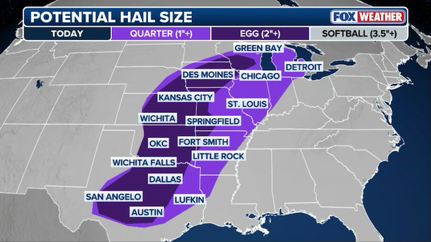
Today's storms could drop huge hail from Texas to Wisconsin.
Supercells are expected to fire up this afternoon, packing enough punch to shatter windshields and dent roofs before they likely merge into a fast-moving, destructive wind line tonight.
If you're anywhere between Texas and Wisconsin, now is the time to get the cars under cover and keep your phone weather alerts on loud, because this spring breakout isn't playing around.
The Southern and Central Plains were battered on Thursday night as a volatile weather system swept through the region, producing a dangerous mix of tornadoes and destructive hail.
The Storm Prediction Center confirmed a total of seven tornado reports, with the most significant activity concentrated in northern Oklahoma and southern Kansas.
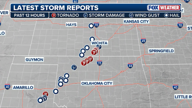
Dozens of severe weather reports show the path of Thursday night's storms in the Plains.
The storm's hammer came in the form of massive hail, with at least 15 reports of large stones that caused widespread property damage. Residents in Lakeview, Texas, reported hail reaching 2.25 inches in diameter—roughly the size of a hen egg—while similar reports of golf-ball to hen-egg-sized hail poured in from Dewey County, Oklahoma, and Sumner County, Kansas.
The combination of high winds and heavy rain left more than 10,000 customers without power across the three-state area as the supercells tore through the night.
As of early Friday morning, emergency crews are still assessing the full extent of the damage. While many of the tornadoes stayed over relatively rural land, the intensity of the storms serve as a stark reminder of the region's vulnerability during the early spring storm season.
This system is now tracking eastward, with a massive corridor stretching from Texas toward the Great Lakes bracing for a potential second round of severe weather later today.
Today is a bit of a "wait and see" kind of day for the Heartland, and while that might sound like good news, the setup actually has meteorologists on high alert.
We are looking at a conditional threat in many areas—which is weather-speak for: if storms can actually get going, they are likely to turn violent very quickly.
The science behind it is a classic spring battle. We have a powerful jet stream screaming overhead and a surge of warm, sticky air pushing up from the Gulf of America. This is creating a lot of fuel in the atmosphere over Oklahoma, Kansas, and Missouri.
If the afternoon heat gets intense enough to force storms to develop, the storms that form will have everything they need to rotate and produce strong tornadoes and very large hail.

Wind shear, or the changing of winds with height in the atmosphere, will create favorable conditions for tornadoes later today.
The most nervous spot on the map right now is ahead of a cold front—that boundary where cooler, dry air clashes with warm, humid air. Forecasters are watching eastern Oklahoma, western Arkansas, and southwest Missouri closely. If a storm can manage to fire up in the area this afternoon, it will be in an environment perfectly cooked for a long-track tornado.
As we head into the evening and overnight hours, the threat doesn't just disappear; it changes shape. A cold front will start pushing through, likely turning those individual storms into a solid line. This means the risk will shift toward damaging wind gusts and spin-up tornadoes along the line as it moves into Arkansas and Missouri.
Since this could happen while you’re sleeping, make sure your FOX Weather App critical weather alerts are turned up loud and your NOAA weather radio is ready to go.
Severe thunderstorms are forecast to slam a dozen states across America's Heartland today.
Millions of people across the central United States should stay weather-aware today as a significant storm system moves through the Heartland.
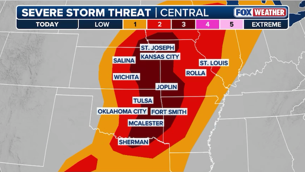
The Storm Prediction Center has issued an Level 3 of 5 severe storm threat area for a corridor including central Oklahoma, eastern Kansas, and western Missouri, where record-breaking warmth is clashing with an incoming cold front.
Major cities like Oklahoma City, Tulsa, Wichita, and Kansas City are in the primary path for these storms, which are expected to fire up between 3:00 p.m. and 6:00 p.m. local time.
The main hazards with this afternoon's activity include the potential for strong tornadoes (EF-2 or higher) and massive hail reaching the size of baseballs. As the evening progresses, these individual storms will likely merge into a fast-moving line capable of producing destructive 80 mph wind gusts as it pushes toward the Mississippi Valley.
You’ve reached the beginning of this live coverage.