Live updates: Severe weather returns to storm-ravaged states, latest forecasts and damage reports
Live updates: Severe weather returns to storm-ravaged states, latest forecasts and damage reports
Download the AppLIVE Severe Weather HQ coverage continues
View postCoverage for this event has ended.
FOX Weather has LIVE 24/7 coverage to help keep you and your family informed before, during, and after severe weather strikes.
This past week, a powerful EF-2 tornado with max wind speeds up to 130 mph ripped through Three Rivers, Michigan, leaving a trail of destruction in its path.
The mayor of Three Rivers, Angel Johnston, joined FOX weather to discuss the damage the town endured and how recovery efforts are going.
She told FOX Weather that the damage from the storm is so extensive she does not recognize areas of the city.

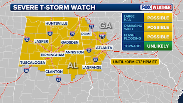
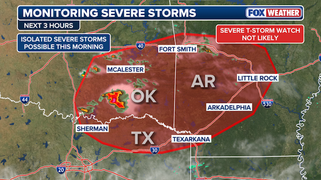
The Severe Thunderstorm Watch has been expanded to include Atlanta, Georgia.
The Severe Thunderstorm Watch currently in effect for parts of Alabama has been expanded to include Atlanta, Georgia.
Large hail, damaging winds and flash flooding are all possible through 10 p.m. CT.
A Tornado Warning is in effect for East Feliciana and St. Helena parishes in Louisiana through 7:15 p.m. CT.
The National Weather Service said southeastern Louisiana could see hail up to two inches in diameter.
The "tornadic thunderstorm" will remain over mainly rural areas, according to the National Weather Service.
Three Rivers Community Schools in Michigan plan to reopen on Tuesday after a strong tornado tore through the area on Friday.
The school district said many staff members helped clean up school grounds and drove routes to prepare for a clean and safe return.
"While the work in the community and around a few of our ancillary buildings is not yet complete, we are excited for tomorrow's return," the school district said on Facebook.

Storm-ravaged states could get hit with even more storms.
Parts of the U.S. that were impacted by a deadly tornado outbreak last week could be slammed with even more storms.
A complicated and potentially significant severe weather setup is expected to develop on Tuesday and continue into Tuesday night.
EF-2 or stronger tornadoes are possible in the Three Rivers/Union City area of Michigan.

That’s where an EF-3 tornado broke out and devastated a community last week.

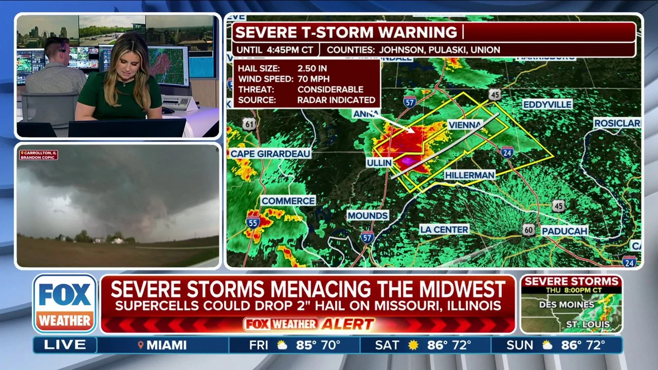
A Tornado Warning has been issued in the Pontotoc, Mississippi, area.
The first Tornado Warning of the night has been issued in Pontotoc, Mississippi, and people in the area are being advised to seek shelter.
The National Weather Service said the warning remains in effect through 5:30 p.m. CT.
A severe thunderstorm capable of producing a tornado was located in the area, moving east at 40 mph with quarter-sized hail.
Radar imagery indicates rotation, and damage to roofs, windows and vehicles is likely. Tree damage is also possible, according to the National Weather Service.
The severe storm threat for Tuesday has increased.
The threat for severe storms on Tuesday is increasing.
Texas is now in a Level 3 out of 5 severe storm threat, with potential EF-2 tornadoes expanding into the Dallas-Fort Worth area.
Strong tornadoes are also possible in the Three Rivers/Union City area of Michigan.
Union City was leveled by devastating tornado damage Friday night. The National Weather Service confirms the strength as an EF-3 tornado.
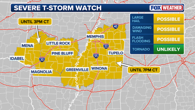
A Severe Thunderstorm Watch has been issued for portions of Mississippi, Tennessee, and Louisiana until 7 p.m. CT.
A new Severe Thunderstorm Watch has been issued for much of northern Mississippi, portions of western Tennessee, and northeastern Louisiana until 7 p.m. CT as a cluster of potent storms charges eastward from Arkansas.
The FOX Forecast Center warns that the primary threats through this afternoon include very large hail—potentially reaching 2 inches in diameter—and damaging wind gusts up to 60 mph.
The watch, which includes cities like Memphis, Tupelo, and Oxford, is in effect as the atmosphere primes itself with warm, humid air ahead of the arriving storms.
While the tornado risk is currently considered low, meteorologists are monitoring for an increase in the tornado threat through the evening across northern Mississippi and Alabama.
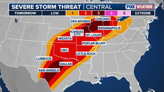
A Level 3 of 5 severe weather threat now includes Central Texas on Tuesday.
The Lone Star State is bracing for a significant increase in severe weather on Tuesday as a volatile setup takes shape along the dryline—the boundary where dry desert air from the west clashes with humid Gulf air to the east.
The FOX Forecast Center is highlighting a broad risk zone extending from the Permian Basin through North Texas, where atmospheric fuel is expected to be at its peak during the afternoon and evening hours.
While much of the state sits under a Level 2 out of 5 risk, a Level 3 of 5 risk area was just introduced by the Storm Prediction Center for much of Central Texas.
The primary concern for Texans will be the potential for discrete supercells capable of dropping massive, damaging hail reaching the size of hen eggs or even baseballs, particularly near the Rio Grande.
While the most concentrated tornado threat is centered farther north in the Midwest, Texas is not in the clear. FOX Weather meteorologists warn that isolated tornadoes could develop, especially in North Texas and near the Red River, if individual storm cells can tap into the increasing twist in the atmosphere late in the day.
As the sun sets, these isolated giants are expected to merge into windy clusters and lines, shifting the threat to damaging straight-line winds and heavy rain that could lead to localized flooding.
Millions of Americans are once again on high alert as the FOX Forecast Center tracks a massive, multi-day severe weather outbreak set to unfold across the heart of the country.
This new wave of severe storms comes just days after a series of deadly tornadoes claimed lives in Michigan and Oklahoma, leaving communities with little time to breathe before the next round of sirens.
Forecasters have already highlighted a Level 3 of 5 for Tuesday, centered over parts of Missouri, Illinois, and Indiana, where conditions appear ripe for rotating supercells and potentially strong tornadoes.
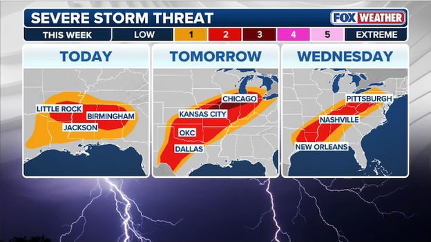
Another multi-day severe weather event is expected to hit America this week.
The threat isn't limited to the Midwest; a vast risk zone stretches from the Texas-Mexico border all the way to the Great Lakes.
On Tuesday, the primary concerns will be tennis ball-sized hail and tornadoes during the afternoon, followed by a transition to damaging wind gusts overnight as storms form into a solid line.
By Wednesday, the energy shifts toward the Deep South and Ohio Valley, bringing the risk of damaging winds, hail, and flash flooding to areas already saturated by last week's rain.

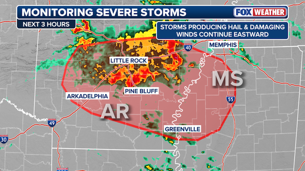
Forecasters at the Storm Prediction Center are closely monitoring a cluster of severe storms rolling through Arkansas.
Right now, a cluster of storms is tracking eastward through Arkansas, with the most intense storms hugging the southern edge of the system.
Thanks to a combination of morning heating and a steady flow of moisture from the south, these storms have plenty of energy to maintain their strength, and the main concerns for people in the path are large hail and damaging wind gusts that could suddenly pick up as the storms move through.
As the day progresses, this cluster is expected to march into northern and central Mississippi.
Because the atmosphere ahead of the storms is becoming increasingly unstable, the Storm Prediction Center is are warning that the risk of severe weather will likely follow the system eastward.
If the storms hold their intensity as they cross the state line, a new Severe Thunderstorm Watch may be issued for Mississippi later today.
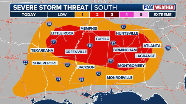
A Level 2 of 5 severe weather threat zone spans across multiple states this afternoon.
FOX Forecast Center meteorologists are monitoring the Deep South for the threat of severe weather this afternoon and evening.
In an early afternoon update, the Storm Prediction Center expanded its damaging wind risk zone eastward to Atlanta and much of north-central Georgia.
After a morning of dense fog and flight delays, the atmosphere is recharging and a cluster of severe thunderstorms is forecast to roar across the South into the evening.
While the coverage may remain scattered, any storm that matures could pack a punch with wind gusts to 60 mph, frequent lightning, and large hail.
While the most significant tornado risk is currently centered farther west, people in the Atlanta metro should not let their guard down this evening. These storms are part of a broader, restless weather pattern that will likely bring more widespread severe weather to the Southeast by mid-week.
The FOX Forecast Center is closely monitoring a developing weather setup that will bring an increasing tornado threat to portions of Alabama and Mississippi later today.
As a warm, humid airmass from the Gulf of America surges northward, it will collide with a passing atmospheric disturbance, providing the fuel needed for robust thunderstorm development.
While large hail and damaging winds to 60 mph remain the primary concern for many, the twist in the winds as you move up through the atmosphere is becoming more favorable for rotating storms, especially across northern Mississippi and Alabama during the mid-to-late afternoon hours.
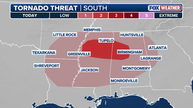
Forecasters are monitoring northern Alabama and Mississippi for an increasing threat of tornadoes later today.
Meteorologists emphasize that while any potential tornadoes may be on an isolated basis today, they can still be dangerous and develop quickly.
People in cities like Jackson, Tupelo, Birmingham, and Tuscaloosa should ensure their FOX Weather App alerts are turned on and have a designated safe place ready to go.
FOX Weather meteorologist Stephen Morgan breaks down the ingredients for today's severe storm threat across the South.
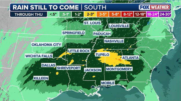
Millions of Americans are on alert for potential flash flooding this week as an additional 1 to 3 inches of rain falls across the central and southern U.S.
In addition to the threat of tornadoes and hail, a significant flash flooding risk is emerging across the central U.S. this week.
As a slow-moving storm system interacts with a surge of moisture from the Gulf, heavy rain is expected to drench areas from East Texas through the Ohio Valley.
The FOX Forecast Center warns that training storms—where multiple storms follow the same path like railroad cars—could drop 1 to 3 inches of rain, with isolated totals reaching 4 inches in some spots.
The risk is particularly high in parts of Missouri, Illinois, and Indiana, where the ground is already saturated from last week’s deadly storms.
This excess moisture cannot soak into the earth, leading to rapid runoff into streets and low-lying areas.
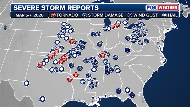
Data from the Storm Prediction Center shows more than 230 reports of severe weather from Thursday to Saturday.
The recent multi-day severe weather outbreak has left a staggering mark on the country, with the Storm Prediction Center logging more than 230 reports of severe weather spanning 21 states from Thursday through Saturday.
This volatile stretch was highlighted by a deadly tornado outbreak that claimed eight lives in Michigan and Oklahoma, including the earliest EF-3 tornado ever recorded in Michigan’s history.
The reports represent a widespread onslaught of atmospheric violence, ranging from giant hail in the Plains to damaging straight-line winds and dozens of tornadoes across the Midwest and South.
A weather disturbance moving out of the Texas Panhandle is setting the stage for a noisy and potentially damaging Monday across the Deep South.
As this system tracks eastward, it is pulling a surge of warm, sticky air from the Gulf of America into Texas, Louisiana, and Arkansas.
This moisture is acting as fuel for a cluster of thunderstorms already beginning to fire up along a stalled front over Oklahoma and Arkansas.
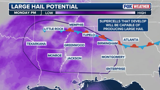
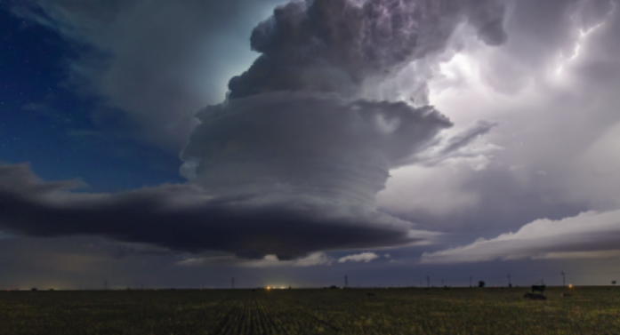
Ingredients are coming together for storms to drop large hail across the South later today.
As we move through the afternoon, these individual storms are expected to band together into a more organized line, often called an MCS (Mesoscale Convective System), which will march across northern Mississippi and Alabama.
While the main concern remains large hail and wind gusts strong enough to knock down tree limbs, the atmosphere has just enough spin to keep FOX Weather forecasters on the lookout for a brief, isolated tornado.
Even after the main line of storms passes, the air behind it will remain unstable, meaning additional scattered storms capable of dropping hail could pop up through the evening.

Four people were killed when tornadoes ripped through Oklahoma during last week's tornado outbreak last week.
Governor Kevin Stitt announced a mother and daughter were killed by a twister that tore through Major County, Oklahoma on Thursday night.
On Friday, the Okmulgee County Sheriff’s Office confirmed two deaths after severe storms blasted central parts of the state.

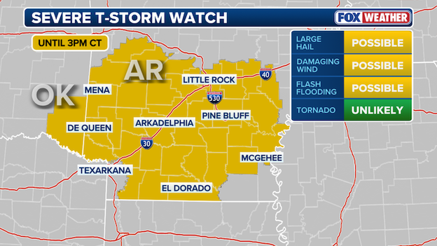
A Severe Thunderstorm Watch has been issued for Arkansas until 3 p.m. CT.
A Severe Thunderstorm Watch has been issued for portions of the southern half of Arkansas and southeast Oklahoma until 3 p.m. CT as a cluster of powerful storms moves through the region this morning.
The FOX Forecast Center warns that the primary threat with this round is large hail, which could reach the size of quarters or larger in the most intense cells, along with the potential for damaging wind gusts up to 60 mph.
While the current activity is focused on the mid-morning hours, the severe storm risk is expected to persist through the late afternoon as a warm front lifts north.
Forecasters note that while hail is the main concern, the atmosphere remains volatile enough that an isolated tornado cannot be entirely ruled out.
Residents in cities like Little Rock, Pine Bluff, and Texarkana should have a way to receive alerts and be prepared to move indoors if warnings are issued for their area.

Courtesy: 517Drone Video and Photography
Drone footage has captured the staggering scale of destruction in Union City, Michigan, where a powerful EF-3 tornado ripped through the lakeside community on Friday afternoon.
The aerial views show flattened homes along Union Lake and massive debris fields in a town still reeling from the deadliest storm event Michigan has seen since 1980.
With maximum winds of 160 mph, this historic twister now holds the record as the earliest EF-3 or stronger tornado ever documented in the state’s history.
FOX Weather Meteorologist Haley Meier reports live on the ground in Union City, Michigan, continuing her coverage from one of the hardest-hit neighborhoods on Prairie Rose Lane, where the destruction has left little behind.
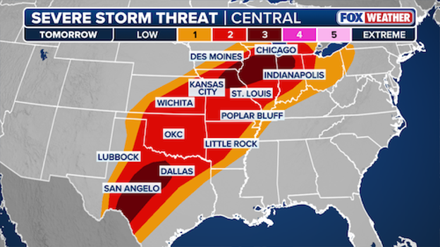
Tuesday’s severe weather setup is a tale of two centers, with the FOX Forecast Center monitoring two distinct corridors of concern: one in Texas and another stretching from Missouri into Illinois and Indiana.
The ingredients for another potential severe weather outbreak are falling into place as two separate storm systems—one from the Southwest and another from the Plains—converge over the heart of the country.
This creates a split-flow pattern that acts like a vacuum, pulling warm, sticky air with dew points in the 60s up from the Gulf of America.
For much of the day, a cap (a layer of warm air aloft that acts like a lid) will likely keep storms from forming. However, as a powerful low-level jet—a ribbon of fast-moving air just above the ground—intensifies late Tuesday afternoon, that lid is expected to pop, triggering explosive thunderstorm development.
What makes or breaks this forecast is how these individual storms interact with different boundaries, like the warm front draped across the Midwest or the dryline in Texas.
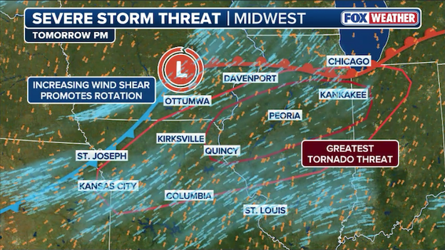
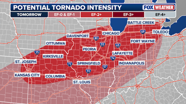
Increasing instability and wind shear will fuel the threat for strong tornadoes on Tuesday.
In the afternoon, the main threats will be isolated supercells, or rotating thunderstorms, which are notorious for producing very large hail (up to 2.5 inches, or tennis ball size).
The greatest danger arrives in the evening near the intersections of these weather fronts; here, the wind shear (changing wind speed and direction with height) is most intense, creating an environment where strong tornadoes (EF-2 or higher) are possible.
As the night goes on, these individual cells will likely clump together into lines, shifting the primary threat to damaging wind gusts that could persist well after sunset as a cold front pushes through the region.
The FOX Forecast Center is monitoring a cluster of thunderstorms developing over Oklahoma this morning.
Scattered severe storms are possible across parts of Oklahoma, Arkansas, and north Texas this morning as a pocket of warm, humid air clashes with an incoming weather disturbance.
While the Storm Prediction Center isn't expecting significant severe weather, the atmosphere is unstable enough that any storm that manages to hold together could produce large hail and gusty winds.
The threat is expected to ramp up and become more organized as it moves into Mississippi and broader parts of Arkansas later today, so residents in these areas should keep an eye on the sky and stay tuned for updates throughout the afternoon.
A complicated and potentially significant severe weather outbreak is taking shape for Tuesday as multiple atmospheric systems converge over the Heartland, threatening many of the same communities devastated by last week's storms.
The FOX Forecast Center warns that an upper-level disturbance moving from the Rockies will interact with a strengthening northern system, pulling warm, humid air from the Gulf across Texas, Oklahoma, and Kansas and into the Ohio Valley. This creates a broad warm sector of unstable air capable of supporting intense thunderstorm development.
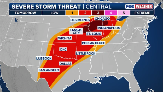
Another round of violent storms and tornadoes is expected to slam the central and southern U.S. on Tuesday.
A Level 3 out of 5 severe storm risk is currently centered over a narrow corridor from Missouri to Indiana, while a broader Level 2 risk stretches from Lake Michigan all the way south to the Texas-Mexico border, encompassing major hubs like Chicago, Dallas, and Indianapolis.
The primary window for danger opens Tuesday afternoon as isolated supercells develop, capable of producing very large hail.
As the evening progresses, these storms are expected to organize into lines as a cold front sweeps through, significantly increasing the tornado threat—particularly along a warm front in the mid-Mississippi Valley.
Residents in cities such as Springfield, Peoria, and Bloomington should be prepared for a long night as a powerful low-level jet will continue to fuel these storms with moisture well after sunset.
This suggests that severe weather and potential tornadoes could remain active overnight, making it critical for those in the path to have a way to receive weather alerts while they sleep.
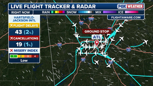
Flights destined for Atlanta are being held at their origin until the ground stop is lifted.
Low clouds have triggered a ground stop at Hartsfield-Jackson Atlanta International Airport (ATL) this morning.
The Federal Aviation Administration (FAA) issued the order to manage arrival flow as visibility remains limited, with the stop currently scheduled to remain in effect until 8:30 a.m. ET.
The stoppage is creating a ripple effect across the Southeast, with flights destined for the world’s busiest airport being held at their points of origin. Travelers should expect significant delays throughout the morning as the airport works to clear the backlog once conditions improve.
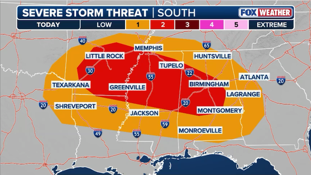
Severe thunderstorms are possible from Arkansas to Alabama later this afternoon and evening.
A new round of severe weather is targeting the South today, just as the region begins a busy week of atmospheric unrest.
The Storm Prediction Center has issued a Level 2 of 5 severe storm risk for a large portion of Mississippi, including cities like Jackson, Tupelo, and Greenville, where storms are expected to fire up this afternoon and persist through the evening hours.
FOX Forecast Center meteorologists warn that these storms could be potent, with the primary threats being damaging wind gusts and hail up to the size of golf balls.
While the tornado threat remains low for today, meteorologists emphasize that tornadoes cannot be ruled out, especially as a warm, moist airmass surges northward.
Residents from western Georgia to East Texas should also remain alert for strong storms that could drop hail and whip up powerful winds as stray severe storms could develop ahead of a much more significant round of storms expected to slam the Midwest and Plains starting tomorrow.

Widespread tornado damage in Union City, Michigan, March 7 (FOX Weather)
Recovery is underway across southwest Michigan following Friday's catastrophic tornado outbreak, which has now been confirmed as the state's deadliest since 1980.
Governor Gretchen Whitmer declared a State of Emergency for Branch, Cass, and St.Joseph counties on Sunday, authorizing all available state resources to assist flattened lakeside communities and devastated downtowns.
The National Weather Service confirmed that the EF-3 tornado that struck Union City—packing winds of 160 mph—is the earliest EF-3 or stronger tornado ever recorded in Michigan's history. The twister is the state's strongest since an F4 struck Kalamazoo and Eaton Counties on April 2, 1977.
Four people were killed, including a 12-year-old boy in Cass County and residents in the Union Lake area.
As of Monday morning, crews from the Michigan State Police and local first responders are working alongside non-profits like the Salvation Army and Convoy of Hope to provide meals, hygiene kits, and power restoration.
While several school districts remain closed today, including Three Rivers Community Schools, the focus remains on door-to-door wellness checks and clearing primary roads before the next round of severe weather arrives on Tuesday.
You’ve reached the beginning of this live coverage.