Live updates: Deadly storm sparks raging wildfires and 70 mph winds, blizzard threatens the Midwest
Live updates: Deadly storm sparks raging wildfires and 70 mph winds, blizzard threatens the Midwest
Download the AppLIVE coverage from FOX Weather continues
View postCoverage for this event has ended.
FOX Weather is your Severe Weather HQ, providing around-the-clock live coverage when severe storms strike.
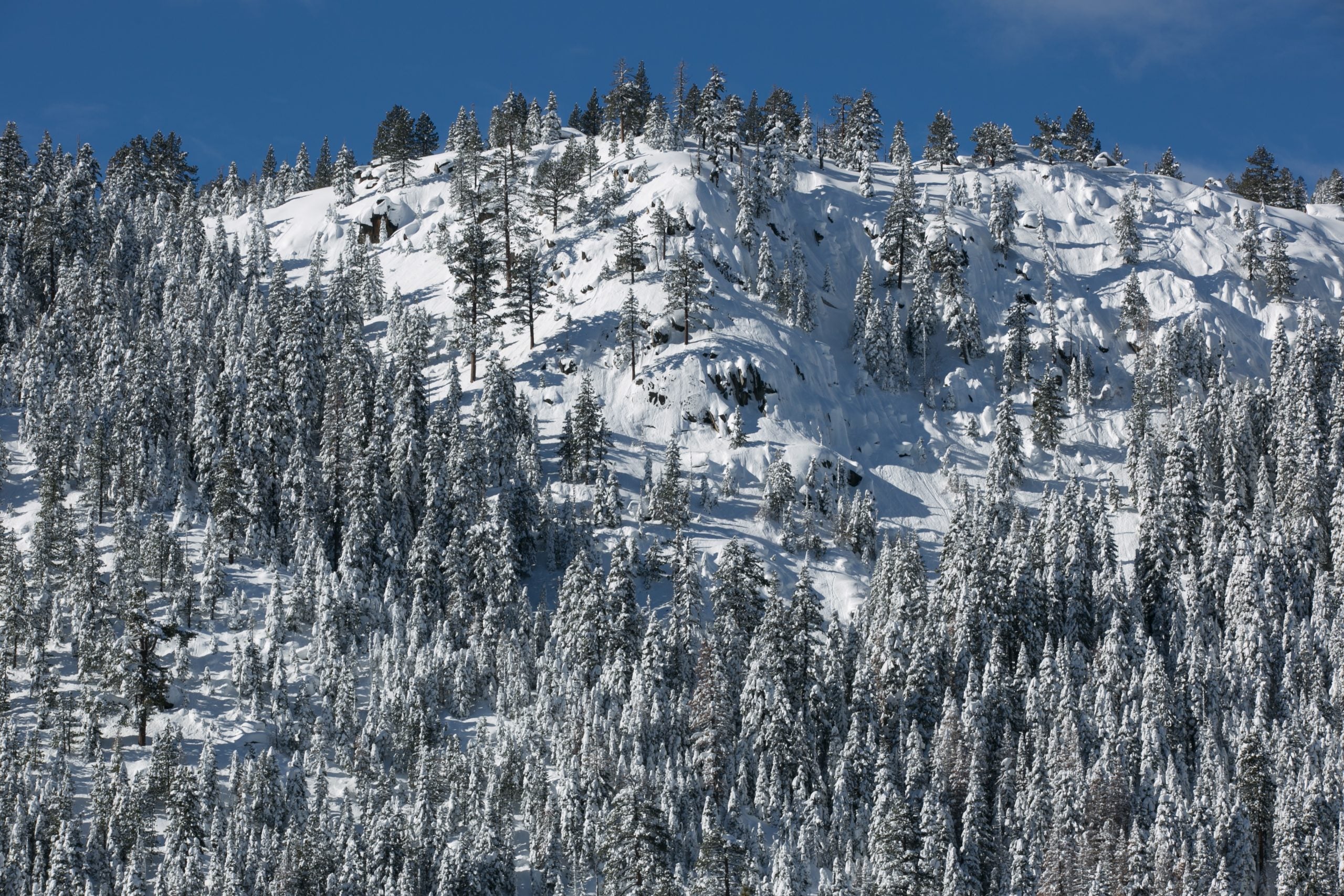
First responders are searching for nine skiers who are missing after a group of 15 people were caught in an avalanche Tuesday morning on Castle Peak in the Truckee, California area of the Sierra Nevada.
Six people from the party were rescued Tuesday night and two were taken to a hospital, the Nevada County Sheriff's Office said.
The National Weather Service in the Bay Area has issued a High Surf Advisory from early Wednesday morning through Friday.
The agency said the advisory is in effect from 3 a.m. Wednesday to 9 a.m. PST on Friday.
Large breaking waves of 18 to 22 feet are possible, with an increased risk for sneaker waves and strong rip currents along the Pacific Coast.
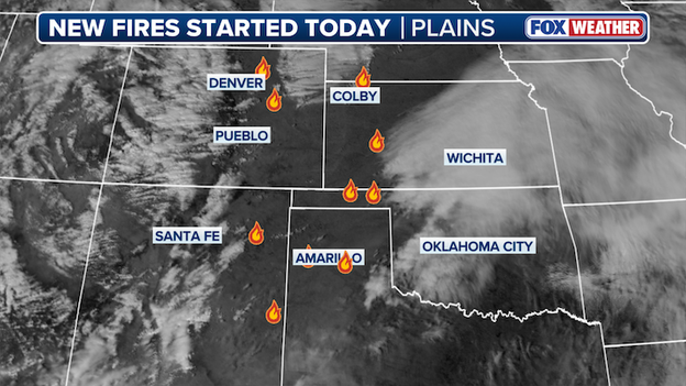
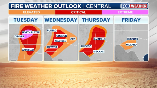
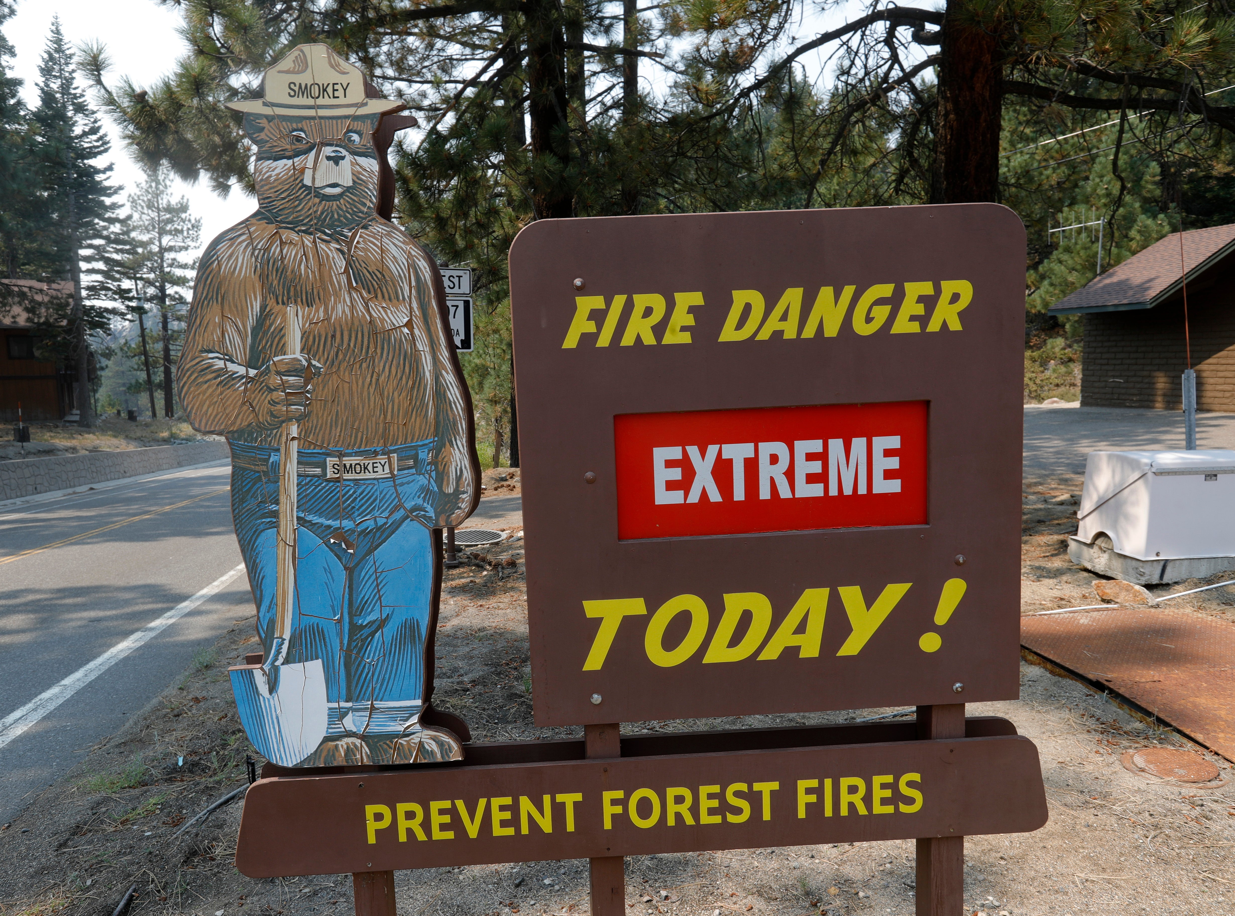
Fires break out in the Plains.
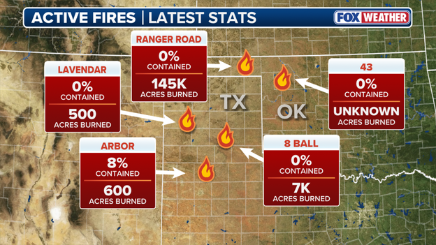
A major wildfire broke out in Beaver County, Oklahoma, and has already burned over 145,000 acres, according to the National Weather Service.
The Plains are seeing vicious winds gusting up to 65 mph.
Click here for the latest on the wildfire outbreak.
Northwestern Oklahoma State University said they've closed and evacuated their Woodward campus due to a wildfire in the area.
The fire is spreading rapidly, prompting officials to issue mandatory evacuation orders for parts of the city.
Multiple fires have erupted in Oklahoma, Kansas, Nebraska, Colorado and Texas as the region endures warm temperatures and wind gusts of over 70 mph combined with a very dry landscape.
A road covered in debris is still closed on the Big Sur coast, according to Caltrans Central Coast District 5.
Officials said the road is closed near Regent's Slide from two miles north of Lucia to one mile south of the Esalen Institute.
The slope above the roadway at Regent's Slide is stable, and crews are waiting for breaks in the rain to clear debris.
It comes after the area saw heavy rain, which led to the mud and debris slide.
FOX Weather Meteorologist Steve Bender analyzes how extremely dry conditions across areas in the Plains have numerous states in the region in the heat of battle against raging wildfires.
A wildfire broke out in Armstrong County, Texas, and it has already burned 5,000 acres.
The 8 Ball fire is 0% contained and is actively spreading. Click here for the latest.
An immediate evacuation notice was issued for the city Woodward, Oklahoma by the Oklahoma Department of Emergency and relayed by the National Weather Service.
The notice states that a large destructive wildfire was burning out of control near Woodward, spreading rapidly to the Northeast.
Individuals between Oklahoma Avenue and Hanks Trail and east of 22nd were urged to leave now "to avoid injury or death."
A driver and two people who stopped to help were seriously injured when a car lost control on a snow-covered highway and hit them in California.
California Highway Patrol said a car was stopped in a turnout on US 50. The driver tried to adjust the chain on the left front tire when two bystanders offered to help.
All three young men were at front of the vehicle trying to fix the tire chain when a truck approaching Johnson Pass lost control and struck the car.
One pedestrian was thrown about 40 feet, and the car came to a stop on the right shoulder. The other two pedestrians were dragged by the car and ultimately freed.
The three people suffered major injuries and were taken to a nearby hospital for treatment.
Governor Kevin Stitt was in Oklahoma's State Emergency Operations Center as several wildfires rage in the state and across the region.
The fires have prompted emergency evacuations in several areas as first responders battle to contain the blaze.
According to Governor Stitt, a wildfire in Beaver County continues to spread as wind gusts over 65 mph.
Over 14,000 households in Texas are being impacted by a Public Safety Power Shutoff due to vicious winds reaching up to 70 mph.
Weather conditions are expected to drop below shutoff thresholds, and Xcel Energy Texas said restoring power could take several hours to several days.
"This is because crews must inspect power lines and repair damage before they can be safely re-energized," Xcel Energy said on social media.
Texas Panhandle customers in the following areas are impacted: Carson, Deaf Smith, Donley, Gray, Hansford, Hartley, Hutchinson, Moore, Oldham, Potter, Randall, Roberts, Sherman, and Swisher counties.
Hundreds of Xcel Energy crew members and contractors are positioned in the panhandle, ready to restore power as outages arise.
This graphic displays new fires that started today in the Plains.
Numerous fires ignited Tuesday across five states, as abnormally dry conditions across the Plains have set the stage for dangerous fire weather.
Fires have erupted in New Mexico, Texas, Oklahoma, Kansas and Colorado as fire weather alerts are scattered across the region.
This is unfolding in a region already dealing with worsening drought and a lack of recent rain and snow, leaving vegetation primed to burn. In this setup, even a small spark from a vehicle, equipment or a power line could ignite a fast moving grass fire.
A perfect alignment of near-record temperatures, wind gusts 40-70 mph, along with relative humidity on either side of 10% will cause any fire that starts, to grow rapidly, and likely out of control.
US 50 West is closed due to a crash involving multiple vehicles, which was caused by blowing dust, according to the Southwest Kansas Department of Transportation.
Crews are redirecting traffic and at this time, it's unknown how long the highway will be closed.
Drivers are being asked to avoid the area and take alternate routes.
The Kansas Department of Transportation has closed U.S. Highway 50 near Garden City (near the U.S. 83 junction) following a crash.
High winds with gusts reaching 60+ mph are currently whipping up blowing dust in Finney County, reducing visibility to near zero and making travel extremely hazardous.
Drivers are being diverted and are strongly urged to avoid all travel in western Kansas until the high wind warnings expire this evening.
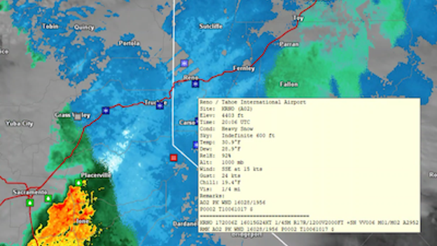
Heavy snow extends beyond Sierra Nevada mountains.
Heavy bouts of snow are now extending beyond the Sierra and into Reno, Nevada.
Reports indicate that visibility is down to 1/4 mile.
Only 1.5 inches of snow has fallen in Reno this winter, which is far below their average to date of 15 inches.
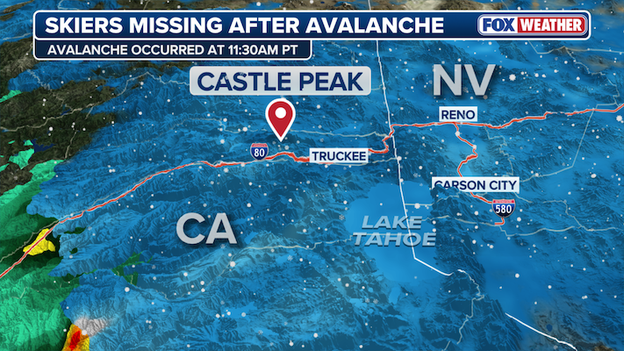
Nevada County Sheriff’s Office says an avalanche occurred at Castle Peak in California on Tuesday.
The Nevada County Sheriff’s Office and search and rescue teams are currently engaged in a high-stakes rescue operation following a major avalanche near Castle Peak, California.
The slide occurred at approximately 11:30 a.m. PT, reportedly involving a group of backcountry skiers.
While some members of the party have been accounted for, the Sheriff’s Office has confirmed that several members are still missing as of this afternoon.
The search is taking place under extremely challenging conditions, as a powerful winter storm continues to lash the Sierra Nevada with heavy snow and high winds.
Both Interstate 80 and Highway 50 remain closed at the summit due to the weather, which has hampered air support and complicated the movement of emergency crews to the remote site.
Agencies from the surrounding region are assisting in the probe, and officials are urging everyone to avoid the Castle Peak area entirely, as the risk of secondary avalanches remains dangerously high.
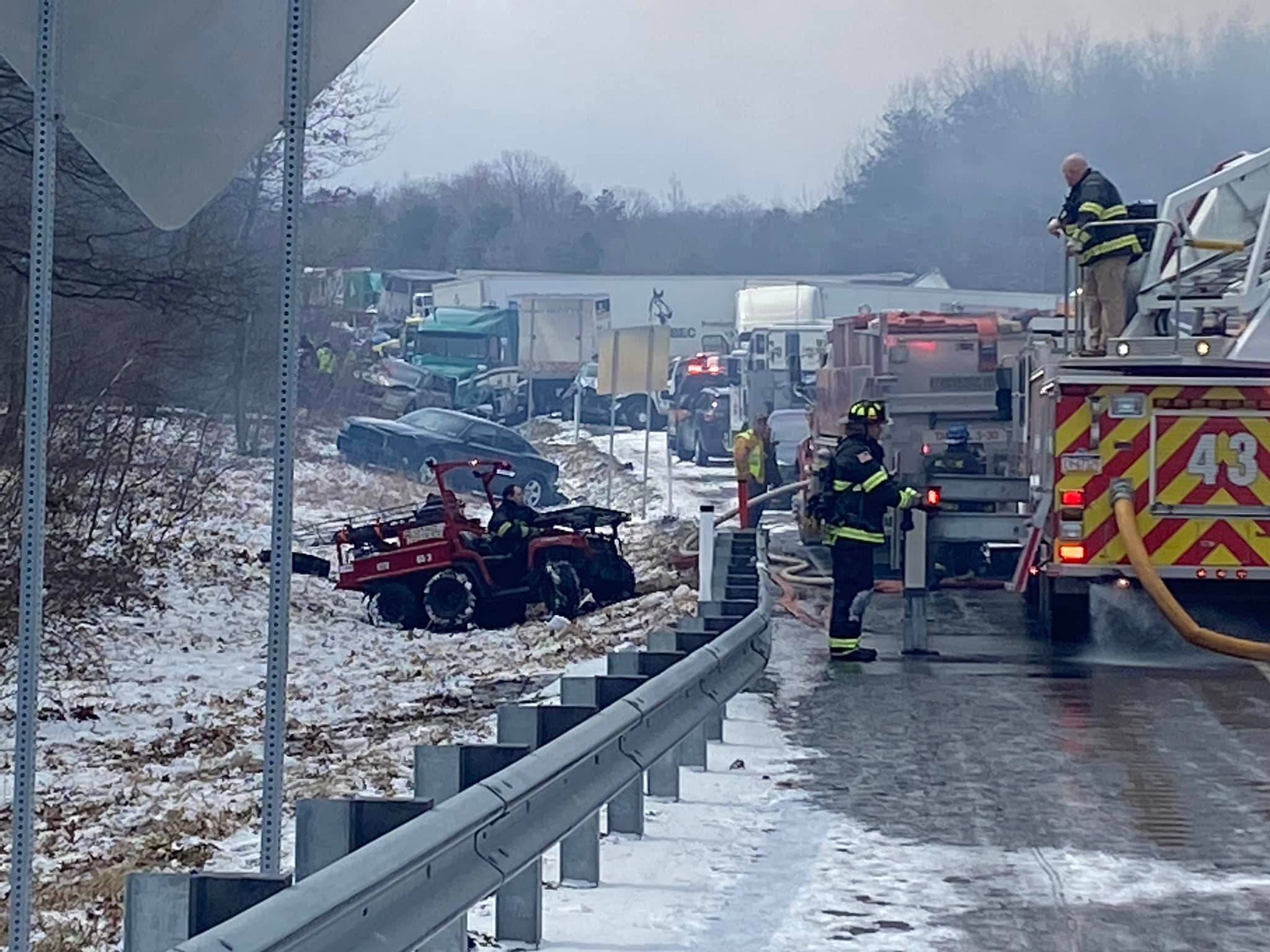
COTrip traffic camera on I-25 near Pueblo, Colorado.
The Colorado State Patrol says a catastrophic multi-vehicle crash happened on Interstate 25 south of Pueblo this morning.
Investigators have confirmed that more than 30 vehicles, including six semi-trucks, were involved in the deadly pileup near Milepost 92 that occurred around 10 a.m. MT.
Hazardous "brown out" conditions—caused by 60+ mph winds kicking up blinding clouds of dirt—left motorists with zero visibility at the time of the collision.
Colorado State Patrol confirms four people were killed. Their identities will be released by the Pueblo County Coroner once next of kin have been notified.
29 people were transported to local hospitals for injuries. Emergency officials say their conditions remain unknown at this time.
The Colorado State Patrol Vehicular Crimes Unit is currently leading the investigation, and the interstate remains closed in both directions with no estimated time for reopening.
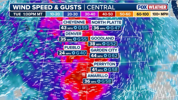
60+ mph winds are ripping across the Plains this afternoon as firefighters battle multiple wildfires.
The FOX Forecast Center says wind speeds continue to increase across the Plains state this afternoon.
Right now, firefighters are battling multiple major blazes across Kansas, Oklahoma, Texas, and Colorado with 60+ mph winds fanning the flames.
These dangerous conditions are making it nearly impossible for fire crews to contain the fires.
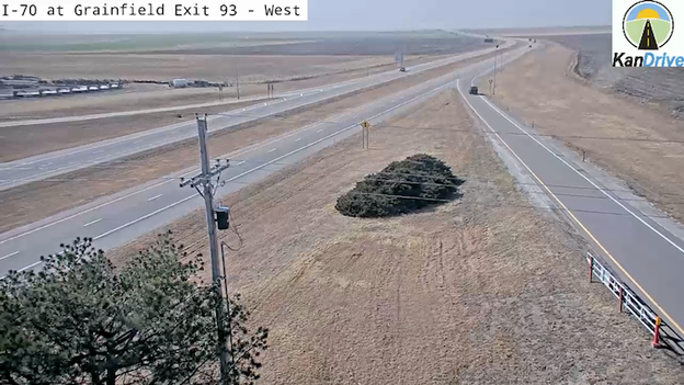
Kansas Department of Transportation traffic camera along Interstate 70 near Grainfield, Kansas.
High winds and bone-dry conditions have forced the Kansas Department of Transportation (KDOT) to shut down Interstate 70 in both directions between Oakley (US 40) and WaKeeney (US 283).
Intense blowing dust is currently reducing visibility to near-zero in spots along the interstate, making travel extremely dangerous across this stretch of the Western Plains.
Officials are urging motorists to avoid the area and seek alternate routes, as the fine dust particles on the road can also reduce traction, making it difficult to control vehicles even at slow speeds.
If you are currently on the road, find a safe place to stop and wait for conditions to improve.
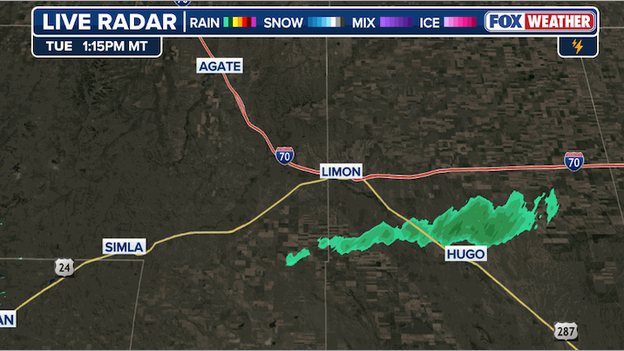
Radar detecting smoke from a raging wildfire south of Limon, Colorado.
A dangerous new wildfire has erupted this afternoon south of Limon, Colorado, and is spreading rapidly across the drought-stricken Eastern Plains.
The National Weather Service in Boulder initially detected a significant smoke plume on Doppler radar, a sign of intense fire activity, as powerful winds push the flames through dormant, dry grasses.
This blaze is currently burning in a high-end critical fire environment where humidity has plummeted to as low as 10%, making containment efforts extremely difficult for responding crews.
Residents in the Limon area and throughout Lincoln County should remain on high alert for immediate evacuation orders, as these tinderbox conditions are expected to support explosive fire growth through the evening.
Operating from a fixed orbit roughly 22,236 miles above the equator, NOAA’s GOES-R series satellites are revolutionizing how Colorado battles fast-moving wildfires.
Using the revolutionary Next Generation Fire System (NGFS), these satellites employ advanced AI algorithms to scan for "heat anomalies" every minute, often spotting ignitions as small as a quarter-acre before they are even reported to 911.
By identifying infrared heat signatures through thick smoke and clouds, this "lookout" provides incident commanders with near-continuous monitoring of a fire’s intensity and movement, allowing for a rapid initial attack that can save lives and millions in property during these extreme high-wind events.
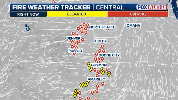
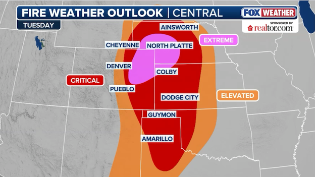
'Critical' fire weather conditions are now occurring across 7 states.
The FOX Forecast Center says 7 states are now experiencing 'critical' fire weather conditions.
This is a dangerous combination of strong winds, exceeding 60 mph in some places, and very dry air with humidity values dropping to near 10%.
These dangerous conditions are making it nearly impossible for firefighters to battle the multiple fires that have erupted in the past few hours across the Plains.
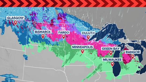
The central U.S. is currently a study in meteorological extremes. While the Southern and Central Plains are battling an extremely critical wildfire outbreak fueled by 70 mph winds and record-shattering heat, the Upper Midwest is bracing for a significant winter wallop.
A powerful low-pressure system is currently deepening over the region, drawing cold Canadian air into a collision course with Gulf moisture. This is creating a dangerous 1,000-mile snow corridor stretching from North Dakota through northern Minnesota and into Wisconsin.
In the Upper Midwest, the threat is twofold: heavy, wet snow and high winds. The National Weather Service has issued Blizzard Warnings for parts of the North Shore and northeast Montana, where snowfall totals could reach as high as two feet.
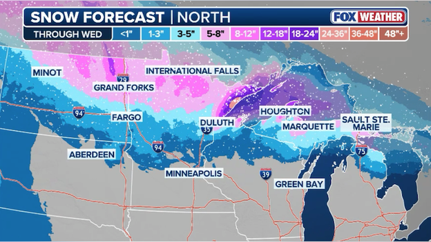
Latest snow forecast from FOX Weather showing heavy snow across the Upper Midwest through Wednesday.
With gusts expected to top 60 mph, visibility will likely drop to near zero, making travel difficult to impossible through Thursday morning.
Whether you are facing the blinding dust of the Plains or the whiteout snow of the North, officials are urging extreme caution as this high-impact system moves eastward.
Latest power outage tracker showing outages state-by-state. (PowerOutage.com)
More than 100,000 customers are without power across multiple states this afternoon thanks to dangerous weather conditions.
According to PowerOutage.com, most of the outages are occurring in California which is dealing with a series of storms dumping heavy rain and snow on the state.
In Texas, energy companies have preemptively cut power to parts of the state as dangerous fire weather conditions threaten to spread out-of-control fires.
A dangerous wildfire outbreak is currently unfolding across the Central and Southern Plains, with multiple large fires erupting in Oklahoma, Kansas, and Texas.
Driven by record-breaking heat and wind gusts up to 70 mph, these fires are sending thick black smoke over area highways, while emergency crews in Clark County, KS, struggle to contain a fast-moving fire threatening the town of Englewood.
Oklahoma is currently managing multiple large incidents that are showing aggressive behavior in the bone-dry grasslands.
The situation remains critical as humidity levels plummet to near 10%, creating a high-risk environment where any new spark can lead to "explosive" fire growth.
Dangerous fire weather conditions are predicted to last through the week across the Plains.
In the Texas Panhandle, Xcel Energy has proactively cut power to 15,000 customers to reduce the risk of power lines sparking new blazes in the powerful winds.
With the State Emergency Operations Center activated and strike teams staged across the region, officials are warning that these extremely critical conditions will likely persist through Thursday.
Emergency officials are evacuating the town of Englewood, Kansas, as a fast-moving wildfire threatens the community.
Driven by powerful wind gusts reaching 65 mph and humidity levels dropping to 10%, the fire is spreading rapidly through dormant, dry grasslands.
Governor Laura Kelly has already declared a State of Disaster Emergency for the region, allowing state resources and National Guard assets to assist local volunteer crews who are struggling to contain the blaze in these extreme conditions.
Residents are urged to leave immediately via designated routes and to avoid all activities that could spark further ignitions, as the extremely critical fire weather is expected to persist through the day.
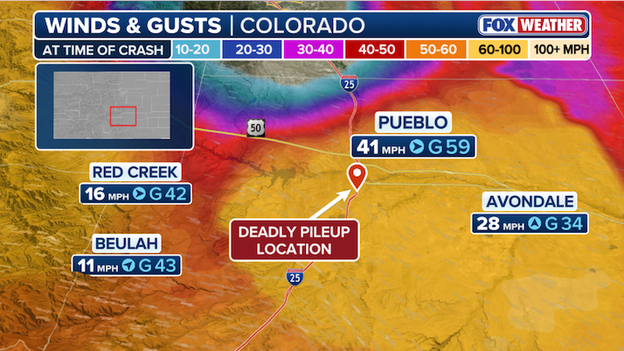
The FOX Forecast Center says winds were gusting around 60 mph in Pueblo, Colorado at the time of Tuesday's deadly multi-vehicle pileup.
The FOX Forecast Center says winds were gusting around 60 mph in Pueblo, Colorado at the time of Tuesday's deadly multi-vehicle pileup on Interstate 25.
Colorado State Patrol says the first 911 call came in just before 10 a.m. MT on Tuesday with high winds and blowing dust reported in the area at the time.
The Sierra Nevada is currently being hammered by one of the most intense winter storms in years, forcing authorities to shut down Interstate 80 to all traffic between Colfax and the California/Nevada state line.
Heavy snow, intense wind gusts, and blowing snow have reduced visibility to near zero, creating what experts are calling some of the worst conditions since 2023.
There is currently no estimated time of reopening as crews work around the clock to clear multiple spinouts and maintain the roadway.
While I-80 remains closed, other mountain corridors are seeing major restrictions as snow levels continue to drop into the foothills.
Highway 50 is currently open, but chains are strictly required between Saw Mill (just before Pollock Pines) and Meyers.
Chain controls are in effect for all major routes around the basin, including Highways 28, 89, and 267.
State Route 49 through Nevada City and Grass Valley is now requiring chains as the cold front pushes snow into lower elevations.
Travel in the Sierra Nevada is strongly discouraged today. Officials advise if you must travel, you are required to carry chains—even if you have four-wheel or all-wheel drive—and should be prepared for sudden closures and extended delays.
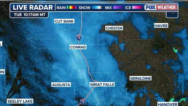
Radar showing a band of heavy snow hammering portions of Montana along Interstate 15 this morning.
Heavy snow and powerful winds are whipping up whiteout conditions along Interstate 15 in Montana at this hour.
The National Weather Service in Great Falls says the snow is falling in 50 mph winds, creating zero visibility at times for drivers from Cascade to Shelby.
A powerful storm is lashing California with a triple threat of heavy rain, intense snow, and dangerous winds.
The National Weather Service in Eureka says hail hit Humboldt Bay, California on Tuesday morning, coating the roads in ice.
Rain and mountain snow is expected to continue through the week as a series of storms rock the region.
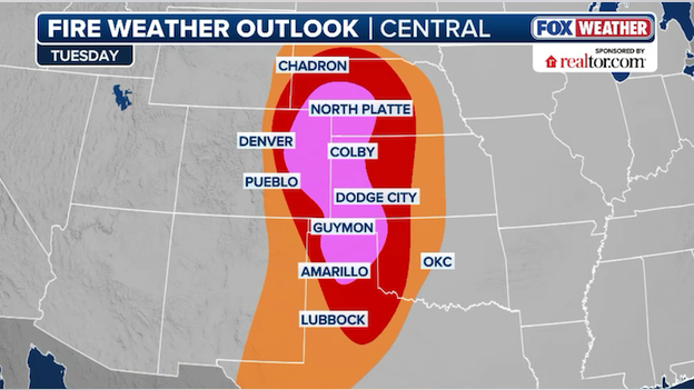
'Extreme' fire weather conditions are developing across the Central and Southern Plains.
Forecasters say the threat area for today's critical fire weather danger has expanded. In a midday update, the Storm Prediction Center just added several states to the 'extreme' critical fire weather danger area.
A powerful weather system is creating a perfect storm for wildfires today, as record-breaking heat and intense winds turn the Central and Southern Plains into a dangerous tinderbox.
Forecasters have issued rare "extremely critical" Fire Weather Warnings for parts of Colorado and Nebraska, where humidity levels are plunging to near 10% and sustained westerly winds are reaching 30 to 40 mph.
These fierce winds, with gusts potentially hitting 60 to 70 mph, are being driven by a deepening low-pressure system that is yanking hot, dry air down from the mountains and across the parched grasslands.
The risk is amplified by exceptional fuel loading from last year's wet growing season, which has left behind a thick carpet of dormant, highly flammable vegetation.
With the ground bone-dry and temperatures soaring up to 20 degrees above average, any spark from outdoor burning or power equipment could ignite a fire that spreads with explosive speed.
People across a seven-state region—including Texas, Oklahoma, and Kansas—are urged to avoid any spark-producing activities, as these rare conditions make new fires almost impossible to control until weather patterns shift.
Check out the snowy conditions in and around South Lake Tahoe, NV shot by FOX Weather Correspondent Robert Ray.
Powerful wind gusts are creating periods of whiteout driving conditions.
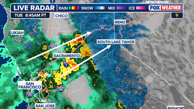
Radar showing where the heaviest snow is aimed at the Sierra Nevada through the afternoon.
A narrow corridor of intense moisture is pointed right at the northern Sierra-Lake Tahoe area right now. At lower elevations, this is falling as heavy rain, but it's all snow in the higher terrain.
The FOX Forecast Center says this is some of the heaviest snow that will be experienced all week with snow rates of 2-3 inches per hour likely.
This intense snow is expected to last through mid-afternoon.
Nearly 15,000 customers are now without power in Texas as the threat of wildfires increases.
Xcel Energy has implemented a Public Safety Power Shutoff (PSPS) across the Texas Panhandle, intentionally cutting electricity to approximately 15,000 customers to prevent wildfires.
This emergency measure covers 14 counties, including Potter, Randall, and Moore, as dangerously strong wind gusts reaching 70 mph and record-breaking dry conditions create an extremely critical fire environment.
Officials expect to begin the restoration process later tonight once weather conditions fall below safety thresholds, but they warn that the process will be slow.
Crews must manually inspect every mile of power line for debris or damage before re-energizing them to ensure they do not inadvertently spark a fire.
Consequently, some residents may remain without power for several hours or even days.
Those relying on medical equipment are urged to use backup power or seek assistance immediately, as fire-favorable conditions are expected to persist through Thursday.
With a rare and dangerous fire outbreak looming over the Plains today, Oklahoma Forestry Services (OFS) has proactively positioned fire suppression groups in Guymon, Woodward, and Shawnee.
These strategic locations allow elite strike teams to respond instantly to any new ignitions in the Panhandle, northwest, and central regions of the state.
The Panhandle and northwestern counties are under particular scrutiny, as exceptional fuel loading from last year's growth has already proven capable of supporting extreme fire behavior during high-wind events.
This staging effort is part of a coordinated response to critical and potentially extreme fire weather conditions.
Residents in these areas are urged to avoid all outdoor activities that could produce a spark as these teams remain on high alert.
The Oklahoma State Emergency Operations Center (EOC) has officially activated today to coordinate the response to critical fire weather and high winds threatening the state.
With extreme fire conditions expected across the Central and Southern Plains, the EOC is standing by to support resource requests from cities and counties facing potential outbreaks.
Forecasters are warning of wind gusts reaching 50 to 75 mph and humidity levels plunging into the single digits, creating a high-risk "tinderbox" scenario.
Residents are urged to remain vigilant and avoid any outdoor activities that could spark a fire, as any new ignitions could spread rapidly and become difficult to control.
A blizzard will blast portions of the Upper Midwest with heavy snow and intense winds.
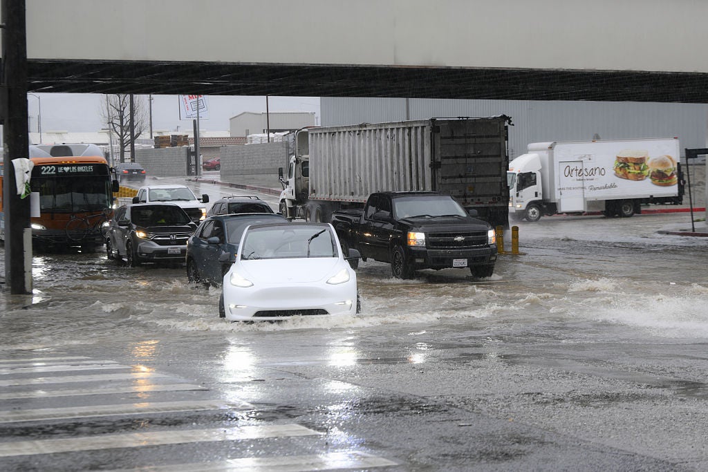
- Los Angeles flooding emergency: A powerful storm drenched Southern California on Monday, triggering Flash Flood Warnings for central Los Angeles, Glendale, and Pasadena.
- Intense rain totals: Coastal and valley areas received up to 3 inches of rain, while mountain communities saw up to 5 inches as of late Monday.
- Continuing California storms: Two additional storm systems are forecast for later this week, keeping Southern California on high alert for further rain and residual flooding risks.
- Upper Midwest blizzard: A Blizzard Warning takes effect tonight for Minnesota's North Shore, including Grand Marais and Silver Bay, with up to 18 inches of snow and 60 mph winds expected.
- Hazardous Midwest travel: Heavy, wet snow and high winds are forecast to create near-zero visibility and potential power outages across northern Minnesota and North Dakota through Thursday.
- 'Extreme' fire danger: A rare "top-tier" fire threat is in effect today for parts of Colorado and Nebraska, as record-breaking heat and hurricane-force wind gusts up to 70 mph combine with humidity as low as 10% to create a high-risk tinderbox across the Central and Southern Plains.
Chain controls are in effect across parts of Interstate 80 in California's Northern Sierra as winter weather worsens.
A Winter Storm Warning remain in effect for the region through 4:00 a.m. local time on Wednesday.
FOX Weather Correspondent Robert Ray will have the latest conditions from South Lake Tahoe, California coming up at 8:00 a.m.
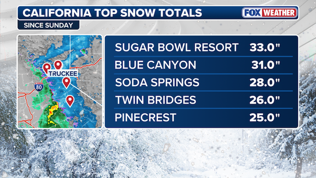
Latest top snow totals from California since Sunday.
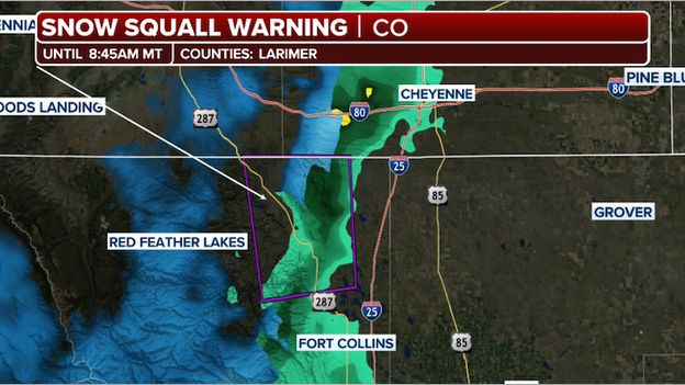
Snow Squall Warning issued for parts of Colorado on Tuesday morning.
A series of intense snow squalls are currently moving through the mountains of the Western United States, creating hazardous, near-zero visibility and dangerous travel conditions during today's morning commute.
The National Weather Service has issued alerts for mountain corridors warning that these quick bursts of heavy snow and wind can cause flash freezing on road surfaces in just minutes.
These squalls typically last between 1 and 3 hours, but they are intense enough to make travel difficult to impossible.
Officials are urging drivers caught in a squall to slow down, turn on headlights and hazard lights, and exit the highway if possible. For those in the mountains, blowing snow and poor visibility are expected to remain a threat through at least Thursday morning.
California’s Sierra Nevada is currently in the crosshairs of a powerful triple threat storm system that could dump up to 10 feet of snow in higher elevations this week.
Forecasters are warning of extreme impacts as snow rates potentially exceed 3 inches per hour in some areas, driven by a deep atmospheric trough pushing subtropical moisture inland.
For those in the mountains, this means near-zero visibility and travel conditions that range from dangerous to completely impossible, particularly along the western slopes and major passes like Interstate 80.
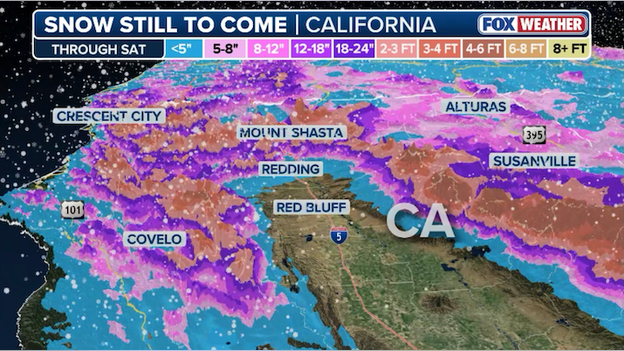
Latest snow forecast from FOX Weather showing an additional 6 feet of snow expected in the Sierra Nevada.
While the immediate focus is on safety and hazardous travel, this massive storm is a critical lifeline for California’s water future.
As of mid-February, the statewide snowpack was lagging at just 53% to 59% of its historical average following a dry December and January.
This multi-day event is expected to provide a much-needed boost to the state's frozen reservoir, which typically supplies about 30% of California’s water needs during the drier months.
With ridgetop winds forecast to gust over 100 mph, the mountains are transforming into a high-stakes winter wonderland that will dictate water availability well into the spring.
Latest snow forecast from FOX Weather showing an inch or two across the Northeast on Wednesday.
A fast-moving winter storm is set to sweep across the Northeast on Wednesday, bringing a quick burst of snow and potential travel headaches for the mid-week commute.
While parts of the region will initially see rain or a messy icy mix as a warm front lifts north, colder air surging in behind the system will transition precipitation to snow from the Upper Midwest through New England.
The most significant accumulations are expected from Upstate New York to Massachusetts, where some areas could see several inches of fresh powder in a short window.
The FOX Forecast Center says an inch or two of snow is expected from Watertown, New York to Boston, Massachusetts.
Travelers should remain alert for rapidly changing visibility and slick roads, particularly where temperatures drop quickly during the afternoon.
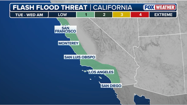
Flash flooding is possible again on Tuesday along the California coast.
After a soggy Monday, another storm system is moving into the West. This disturbance is shifting into California, bringing a fresh round of showers and even some thunderstorms to the coast and southern parts of the state by this evening.
While this storm might not be the most intense seen in recent days, it brings the threat of more flash flooding along the California coast.
Most areas will see steady rain, but some spots could get hit with quick downpours of up to 1 inch in a short window.
Because the ground is already soaked from Monday’s storms, the soil can’t absorb much more water. This makes urban areas and recent burn scars especially vulnerable to fast-moving runoff or mudslides.
In response to the extreme fire weather conditions gripping the Texas Panhandle, Dalhart Independent School District (DISD) has canceled all classes for Tuesday.
The decision comes as the region faces a tinderbox scenario characterized by dangerously strong wind gusts and record-breaking heat, making the threat of fast-moving wildfires a top priority for student and staff safety.
In a proactive effort to prevent wildfires during today's extreme weather conditions, Xcel Energy has announced a Public Safety Power Shutoff (PSPS) starting at 9 a.m. CT.
This critical measure is a response to a Fire Weather Warning issued by the National Weather Service, which cites high winds, very low humidity, and extremely dry vegetation as significant risks for rapid wildfire spread.
Approximately 15,000 customers across 14 counties in the Texas Panhandle are expected to be affected by this planned outage.
Impacted counties include:
- Carson, Deaf Smith, Donley, and Gray
- Hansford, Hartley, Hutchinson, and Moore
- Oldham, Potter, Randall, and Roberts
- Sherman and Swisher
Xcel Energy says additional unplanned outages may occur outside of the designated PSPS areas. Check the Xcel Energy Outage Map to see if your address is within the impact zone.
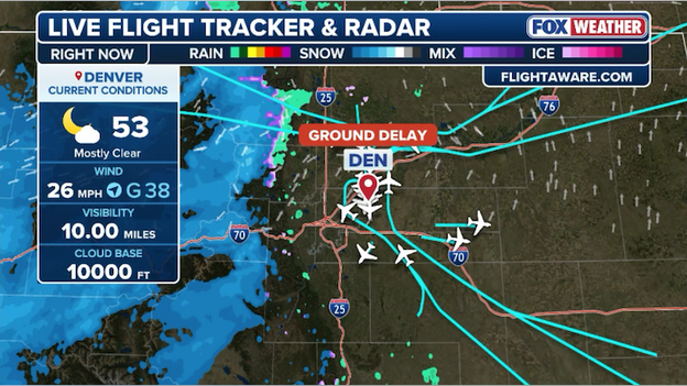
Strong winds are being reported at Denver International Airport this morning.
Denver International Airport (DEN) travelers are gearing up for big delays and potential cancellations thanks to strong winds in Colorado.
The Federal Aviation Administration (FAA) just instituted a ground delay program for the airport, meaning flights destined to DIA are subject to delays of nearly 2 hours.
Passengers are strongly encouraged to check their flight status before heading to the airport.
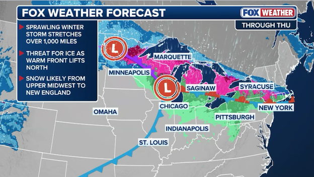
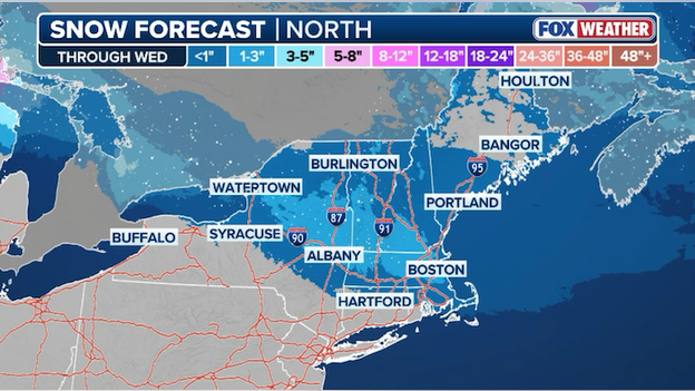
A powerful winter storm will lash the northern tier with heavy snow, intense winds, and ice.
A massive winter storm, stretching over 1,000 miles as it sweeps across the country's northern tier, is threatening to bury communities in the Upper Midwest.
The FOX Forecast Center is tracking a potent setup where a warm front lifting north will bring an initial threat of dangerous ice before transitioning to heavy snow.
FOX Weather meteorologists say the hardest-hit areas, particularly along Minnesota’s North Shore, could see more than 24 inches of snow by Wednesday night.
Fierce wind gusts between 40 and 60 mph are expected to create localized whiteouts and near-zero visibility, making travel difficult to impossible in the Red River Valley.
South of the heavy snow, significant ice accumulation is possible from Minnesota to Michigan as warmer air clashes with the arctic chill.
The sudden wildfire crisis gripping the Central and Southern Plains is the result of a rare, high-impact alignment of meteorological and environmental factors known as a Southern Plains Wildfire Outbreak (SPWO).
While these events represent only 3% of reported wildfires in the region, they historically account for nearly half of the total acreage burned.
The current crisis is being fueled by a snow drought that left lower-elevation grasslands exposed and dry earlier than normal, followed by record-breaking February heat and powerful wind gusts exceeding 60–70 mph.
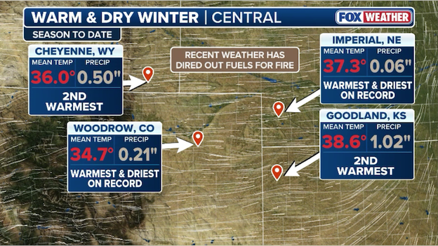
Warm, dry weather is setting the stage for 'extreme' fire weather conditions in the Plains today.
Beyond the immediate weather, a critical fuel loading issue from the previous year is amplifying the danger.
Above-average precipitation in 2025 led to exceptional grass growth across Texas, Oklahoma, and Kansas.
Now that this vegetation has become freeze-cured and dormant, it has transformed into a vast, highly flammable carpet of fuel.
When paired with a weak La Niña climate pattern—which typically brings warmer and drier conditions to the Plains—even a minor spark can ignite fires that are virtually impossible to contain.
Today's forecast of 60 mph winds and critically low humidity (10%) combined with the dry grasses across the landscape could produce massive wildland fires that spread out of control, threatening millions of people across 8 states.
Millions across the Central and Southern Plains are under high alert today as a dangerous combination of record heat, plummeting humidity, and fierce winds creates a tinderbox scenario across several states.
The National Weather Service has issued Fire Weather Warnings and Fire Weather Watches for vast stretches of Nebraska, Kansas, Oklahoma, Texas, South Dakota, Colorado, and Wyoming, where any fire that starts is expected to spread with explosive speed.
- Howling winds: Today's extreme threat is being driven by powerful west to southwest winds sustained at 25 to 45 mph, with powerful gusts reaching as high as 55 to 65 mph in some areas.
- Hopeless humidity: Relative humidity levels are expected to drop to critical lows between as low as 10%, drying out dormant grasses and fuels.
- Record-breaking heat: Temperatures are expected to soar 10 to 20 degrees above average, with highs reaching the 70s and 80s in regions like North and Central Texas.
'Extreme' fire weather conditions are expected today across the Plains states.
Officials are urging the public to avoid any outdoor activities that could produce sparks, including outdoor burning, using power equipment, or discarding cigarettes improperly. With fire activity already trending above the 10-year average for this time of year, residents are advised to remain vigilant as these conditions can change rapidly.
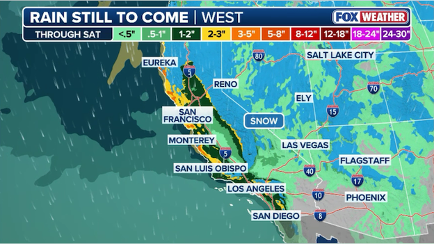
FOX Weather meteorologists say an additional 3 to 5 inches of rain is expected through the end of the workweek along the California coast.
California is grappling with a triple threat as a series of storms slam the state with heavy rain, damaging winds, and historic snow.
While coastal valleys should expect an additional 3-5 inches of rain, the FOX Forecast Center says higher mountain elevations are bracing for up to 8 feet of snow through the week.
This intense moisture has triggered Flash Flood Warnings and evacuation alerts in Southern California, particularly near wildfire burn scars, while hurricane-force wind gusts up to 70 mph threaten to down power lines and trees.
The hazardous conditions are significantly impacting travel and daily operations across the region. Major routes like Interstate 80 and Topanga Canyon Boulevard have been closed due to whiteout conditions and debris slides, while airports like Los Angeles International report hundreds of flight delays.
Although these storms will provide a much-needed boost to California’s snowpack—which currently sits at just half of normal—the immediate risks of flooding and near-impossible mountain travel remain high through at least late Wednesday.
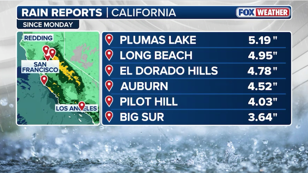
Top rain reports from across California since Monday.
California is currently in the grip of a dangerous storm system triggering life-threatening flash floods, massive mountain snow, and damaging winds.
Emergency crews have been pushed to the limit as intense rain, reaching rates of up to 2 inch per hour, transformed streets into rivers across the Los Angeles Basin. The Los Angeles Fire Department (LAFD) responded to the intersection of West Olympic and Sawtelle Boulevards, where seven vehicles became hopelessly trapped in deep floodwaters and firefighters assisted at least one person to safety from their submerged car.
The California Office of Emergency Services has pre-positioned fire and rescue personnel in high-risk zones, especially near wildfire-scarred areas prone to debris flows.
The storm's triple threat of rain, snow, and wind has brought travel to a standstill in multiple regions. Caltrans closed Topanga Canyon Boulevard (SR-27) in both directions from the Pacific Coast Highway to Grand View Drive due to mud and debris slides covering the roadway.
On Monday, authorities held all traffic on Interstate 80 over Donner Summit as the storm created whiteout conditions. State Route 88 was also closed for avalanche control measures.
In Southern California, Six Flags Magic Mountain was closed Monday, and Knott's Berry Farm shut its gates early due to the deteriorating weather.
With rain totals of 2 to 5 inches expected in the mountains, Los Angeles officials issued evacuation warnings for neighborhoods situated in recent burn scars. Residents in the Palisades, Sunset, and Hurst fire burn areas have been warned to be ready to leave immediately due to the imminent risk of mudslides and debris flows.
A major transition from record-breaking warmth to an intense winter setup is unfolding as a potent storm system moves through the Upper Midwest. While the southern half of Minnesota remains warm enough for rain, a narrow but powerful band of heavy, wet snow is expected to dump 8 to 15 inches across central and northern regions.
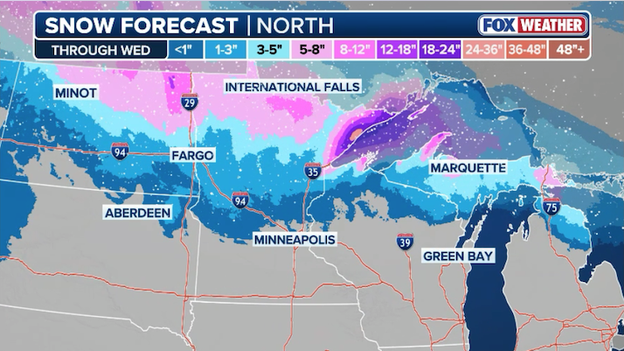
Latest snow forecast from FOX Weather showing where two feet of snow could fall through Wednesday.
The highest accumulations are forecast for the North Shore, where totals could climb to 24 inches through Wednesday.
Travel is expected to become difficult to impossible as the heavy snow combines with fierce 40 to 60 mph wind gusts to create localized whiteout conditions. Because of the high moisture content, this "concrete" snow will likely clump on power lines and trees, raising the risk for widespread outages throughout Minnesota and into the Upper Peninsula of Michigan.
Crews are already on high alert, and drivers are urged to avoid unnecessary travel as visibility drops to near-zero in the hardest-hit zones.
A powerful winter storm is rapidly developing as it moves closer to the Upper Midwest, following a sharp transition from record-breaking warmth to a classic arctic setup.
The system is being fueled by an intense upper-level trough that has already battered California and is now shifting its energy toward the Great Lakes and Northern Plains.
As the storm advances today, rain and a messy mix of freezing precipitation will quickly change over to heavy, wet snow, driven by falling temperatures that threaten to flash freeze regional road.

Winter weather alerts span from Montana to the Great Lakes with Blizzard Warnings in effect for thousands of people.
The snow forecast remains significant, with a narrow but potent band expected to dump 8 to 18 inches of snow across central Minnesota and into the Upper Peninsula of Michigan. Extreme conditions are anticipated along the North Shore, where totals could climb toward 18 inches.
Combined with fierce 40 to 60 mph wind gusts, these intense snow rates will produce near-zero visibility and localized whiteout conditions, making travel through the Red River Valley and northern Minnesota difficult to impossible through at least Wednesday.
You can go back and see LIVE updates from Monday's coverage.
Click here to see the minute-by-minute updates from FOX Weather.
You’ve reached the beginning of this live coverage.