Live updates: 8 missing skiers found dead, search continues for final victim in California avalanche
Live updates: 8 missing skiers found dead, search continues for final victim in California avalanche
Download the AppLIVE coverage from FOX Weather continues
View postCoverage for this event has ended.
FOX Weather is your Severe Weather HQ, providing around-the-clock live coverage to help keep your family safe.
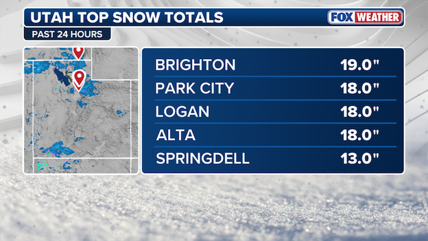
The FOX Forecast Center is monitoring Utah snow totals.
Utah ski resorts were dealt another round of snow Wednesday, with several major mountains recording over 18 inches of snow.
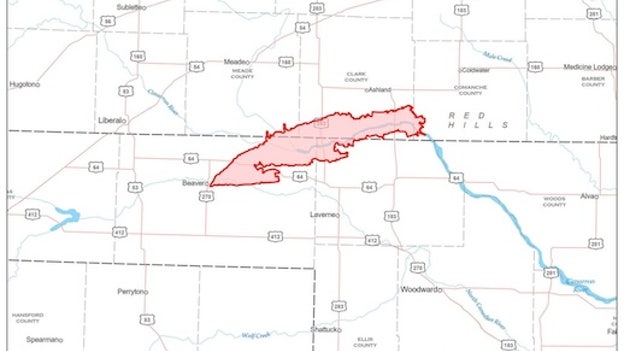
Map courtesy of Oklahoma Forestry Services
The Ranger Road fire has burned more than 280,000 acres and spread from the Oklahoma Panhandle into Kansas as of 12 pm CST, according to a perimeter map from Oklahoma Forestry Services.
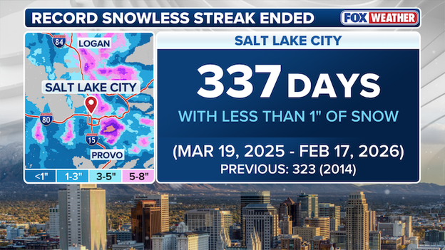
FOX Forecast Center is monitoring snow totals in Salt Lake City.
A record snowless streak has ended in Salt Lake City after more than an inch of snow was recorded for the first time in 337 days.
The streak dating back to March 19, 2025 ended after Utah's capital city recorded more than an inch of snow yesterday, surpassing the previous record set in 2014 of 323 days with with less than an inch of snow.
Salt Lake City is now up to 1.6" of snow this winter but typically averages 38.8" to this point.
Two major resorts in Utah closed their mountains early as a strong snowstorm slammed the state with heavy snow, causing dangerous conditions in the popular ski areas.
Alta Ski Area and Brighton Resorts closed their mountains early as the much-needed winter storm has delivered the snow skiers in Utah have been missing out on this year.
In a post on X, Brighton Resorts wrote, "For the safety of our staff & customers along with continued heavy snow canyon conditions we are closing early today."
In the wake of the catastrophic events at Castle Peak, many are hearing the slide described as a "D2.5" or a "large" avalanche.
These terms aren't just descriptive; they are part of the Destructive Force Scale (D-Scale), a standardized system used across North America and Europe to categorize the power and potential impact of an avalanche based on its mass and what it can destroy.
The scale ranges from D1 to D5, and it is important to understand that the jump between levels isn't just a step up—it's an exponential increase in power:
- D1 (Small): Relatively harmless to people, though it can push a person around. These are often called sluffs.
- D2 (Medium/Large): This is the threshold for tragedy. A D2 avalanche is large enough to bury, injure, or kill a person. Most fatal skier-triggered avalanches fall into this category.
- D3 (Very Large): These slides can bury and destroy a car, damage a truck, or even knock down small buildings and break mature trees.
- D4 (Historic): A massive event capable of destroying a railway car, large trucks, several buildings, or up to 10 acres of forest.
- D5 (Maximum): The largest snow avalanches known. These have the power to gouge the landscape, destroy entire villages, or level 100 acres of mature forest.
The D2.5 rating given to the Castle Peak slide on Tuesday indicates it was a "high-end" D2—possessing enough force to easily bury multiple people and carry them through rugged terrain.
Because these ratings are based on destructive potential rather than just the length of the slide, they provide first responders and forecasters with a clear picture of the survivor-survivability and the specialized equipment needed for a recovery mission.
According to available records, the recovery of eight deceased skiers at Castle Peak has cemented this week’s avalanche as the deadliest in the modern history of the Sierra Nevada.
With the death toll rising to eight—and one person still missing—this disaster has surpassed the tragic 1982 Alpine Meadows avalanche, which claimed seven lives and stood for 44 years as the benchmark for mountain tragedy in California.
This event is not only a local catastrophe but a national one; it is now the deadliest single avalanche in the United States since 1981, when 11 climbers were killed on Mount Rainier.
The scale of this loss is staggering when compared to national averages.
The National Avalanche Center reports that the entire U.S. typically sees between 25 and 30 avalanche fatalities in a full year—meaning this single slide near Donner Summit accounts for nearly a third of the country's annual toll in just one morning.
Teams continue to probe the massive debris field for the final missing member of the party before another winter storm arrives on Thursday.

Rescuers are searching for a missing skier on Castle Peak in California.
A harrowing rescue operation at Castle Peak continues as rescuers scramble to find a missing skier, while the Sheriff's Office says 8 of the missing skiers were found dead.
The group, consisting of 11 clients and 4 professional guides from Blackbird Mountain Guides, was on the final leg of a three-day backcountry excursion when the slide struck around 11:30 a.m. PT Tuesday.
While initial reports were hopeful, the Nevada County Sheriff’s Office now confirms that eight individuals have died and one remains missing as search efforts continue in the rugged Sierra Nevada wilderness.
The rescue mission has been an grueling battle against nature. Highly skilled teams were dispatched immediately, but extreme blizzard conditions and the constant threat of secondary slides forced crews to move with painstaking caution.
Rescuers were forced to ski two miles through deep powder to reach the remote location near the Frog Lake huts, finally arriving around 5:30 p.m. PT Tuesday.
They located six survivors who had managed to shelter to shield themselves from the freezing winds.
The evacuation of the survivors was a monumental task; two of the skiers were non-mobile due to their injuries and had to be carried two miles back through the snow to a waiting snowcat.
Among the rescued are one Blackbird mountain guide and five clients.
As of Wednesday afternoon, search and rescue personnel remain on the mountain, utilizing every available resource to locate the one person still unaccounted for at this hour.
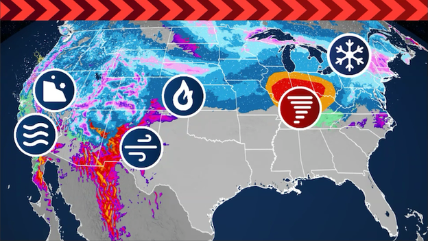
FOX Weather is tracking multiple threats: flooding rains, insane snow, high winds, and severe storms.
- Sierra avalanche: The search for 9 missing backcountry skiers near Truckee, CA, continues under high avalanche danger. While 6 survivors were rescued late yesterday, dozens of responders are battling whiteout conditions to reach the remaining group.
- Plains fire outbreak: Over 145,000 acres have burned as the Ranger Road Fire crossed from Oklahoma into Kansas, forcing the evacuation of thousands of people in Englewood and Ashland. High winds and dangerously dry conditions are expected again today across the Plains.
- Midwest blizzard: A blizzard is hammering the Upper Midwest, with up to two feet of snow and 60 mph winds forecast for northern Minnesota through Thursday morning.
- Tornado threat: Severe storms are expected to spin up a few tornadoes, damaging winds, and large hail across portions of the Ohio and Mississippi Valleys on Thursday.
- Nor'easter brewing: Millions along I-95 in the Northeast are bracing for a potential nor'easter that could slam the region with heavy snow late this weekend.
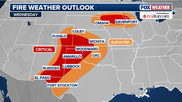
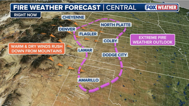
Critical fire weather conditions are expected to develop across multiple states this afternoon.
Meteorologists are keeping a close watch on two geographically distinct but equally dangerous wildfire "hotspots" today as unseasonably warm air and powerful winds sweep across the central United States.
In the Midwest, an extremely rare February Fire Weather Warning has been issued for the Chicago area, specifically for counties along and west of the Fox Valley and I-55.
The threat here is driven by a trifecta of risk factors: temperatures soaring into the mid-to-upper 60s, relative humidity plunging to a desert-like 15%, and southwest wind gusts reaching 40 mph.
These conditions are exceptionally dangerous because they are acting on dormant, dry winter grasses that can ignite from a single spark and spread flames across the flat terrain at incredible speeds.
Farther south, a much larger and more established fire emergency is unfolding across the Southern Plains, where a massive wildfire in the Oklahoma Panhandle has already scorched over 145,000 acres and crossed state lines into both Texas and Kansas.
This region is under a high-end critical fire weather threat as powerful gusts of 60–70 mph hammer the area, making aerial firefighting nearly impossible.
The Southern Plains are grappling with even lower humidity—often in the single digits—and a prolonged drought that has left rangeland and pastures primed for explosive fire growth.
In both regions, officials are urging residents to avoid all outdoor activities that could cause a spark, including parking vehicles over dry grass or using power tools, as the high winds can turn a small brush fire into an uncontrollable blaze in a matter of minutes.
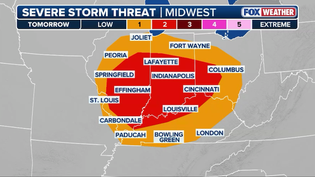
Severe storms are expected to fire up across the mid-Mississippi and lower Ohio Valleys on Thursday, but it's not a cut and dry threat.
The FOX Forecast Center says this early-season setup is being driven by a seasonably strong 115 mph jet streak—think of this as a localized "river of air" within the higher-altitude jet stream that acts like a turbo-booster for developing storms.
This high-speed wind, combined with a strengthening low-pressure system, will pull warm air into the region. This will cause temperatures to surge into the unseasonably warm 60s and 70s.
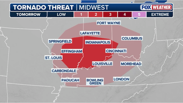
Tornadoes will be possible across Illinois, Indiana, Ohio, and Kentucky on Thursday.
The primary tug-of-war in Thursday's forecast is between instability and shear. While massive amounts of humid "fuel" (CAPE) won't be present, the 115 mph jet streak provides so much atmospheric twist and lift that it can compensate for the lack of heat.
As of now, the primary areas of concern include central and southern Illinois and Indiana, as well as parts of western and northern Kentucky and southwestern Ohio.
FOX Weather meteorologists say the threat is expected to increase as early as Thursday afternoon near the Greater St. Louis area before intensifying as it spreads eastward into central Indiana by early evening.
While the exact instability—the "fuel" or atmospheric energy needed to keep a storm growing—remains a question, overall conditions are highly supportive of rotating supercells.
These are highly organized, long-lived thunderstorms with a spinning heart (called a mesocyclone) that makes them much more dangerous and capable of producing a few tornadoes and severe hail.
As the system progresses, these individual supercells are expected to merge into a line of storms. When this happens, the primary threat shifts from individual tornadoes to damaging straight-line wind gusts up to 65 mph.
Residents in cities like Indianapolis, Springfield, and Louisville should remain weather-aware, as the transition from record warmth to severe weather will be rapid.
The Nevada County Sheriff’s Office has scheduled a press conference for 11:00 a.m. PT (2:00 p.m. ET) to provide the latest information on the search for nine missing backcountry skiers.
Following yesterday’s massive avalanche near Frog Lake, officials are expected to update the public on the status of the ongoing rescue mission and the condition of the six survivors who were successfully extracted late Tuesday night.
All lanes of northbound Interstate 25 south of Pueblo have officially reopened following a devastating 36-vehicle pileup that paralyzed the corridor on Tuesday morning.
In a sobering update from the Colorado State Patrol, the death toll from the crash has risen to five after one of the 29 individuals transported to a local hospital succumbed to their injuries overnight.
The initial collision, which occurred around 10:02 a.m. MT near mile marker 92, involved seven semi-trucks and dozens of passenger vehicles that became entangled when powerful wind gusts triggered a sudden brownout.
COTrip traffic camera on I-25 near Pueblo, Colorado on Tuesday.
The blinding dust created near-zero visibility for motorists, leading to the massive chain-reaction crash that investigators are still working to piece together.
As cleanup crews have cleared the wreckage and travel has resumed, the Colorado State Patrol Vehicular Crimes Unit continues its investigation into the sequence of events.
Officials remind drivers that while the lanes are open, high winds remain a factor in the area, and extreme caution is advised.
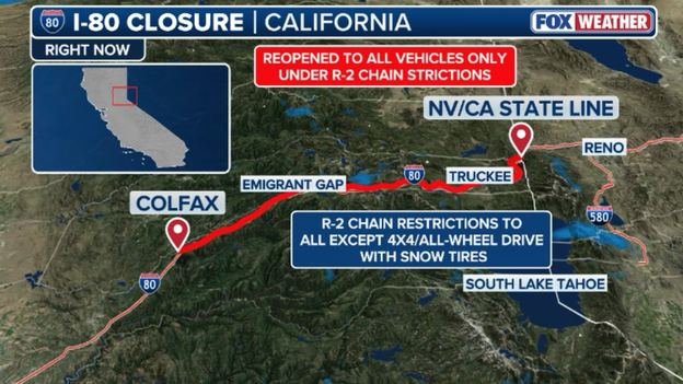
I-80 has reopened in both directions
Interstate 80 has reopened over the Donner Pass in the Sierra, but chain restrictions are in place.
I-80 was shut down most of Tuesday due to blizzard conditions.
Experts say the catastrophic avalanche at Castle Peak on Tuesday was the result of a "perfect storm" of dangerous snowpack conditions, as feet of new snow and gale-force winds overwhelmed a fragile, pre-existing base of snow.
While the primary storm is winding down this morning, the Sierra Avalanche Center warned that the snowpack remains under extreme stress. Ongoing loading from light snow and wind-driven snow transport continues to heighten the risk of large to very large avalanches.
These slides can take the form of wind-drifted slabs in gully features and on open slopes, or dangerous sluffs in steeper terrain.
Because cold temperatures are currently slowing the settlement and stabilization of the new snow, travel in or below avalanche terrain is strictly discouraged today.
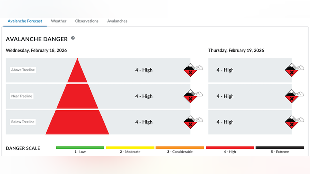
Sierra Avalanche Center website shows the threat for avalanches remains "high" across the Central Sierra Nevada.
According to the Sierra Avalanche Center, a major concern for search and rescue teams is a specific facet layer—a sugary, weak shelf of snow that formed during an extended dry spell in January and was buried by snow on February 10.
This layer exists on northwest, north, and northeast aspects above 7,500 feet and is suspected to be a contributing factor in yesterday’s disaster.
Avalanches involving this particular weak layer are notoriously dangerous because they can break much wider than expected and can be triggered from mid-slope or even from below.
This week's massive snowfall has also buried early-season obstacles like rocks and downed trees under a deceptive layer of low-density powder, creating additional hidden hazards for anyone venturing into the backcountry.
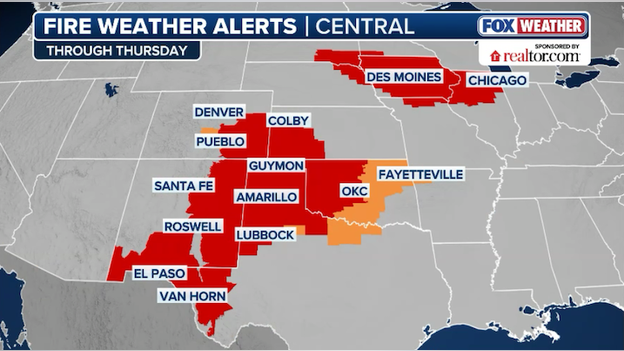
Fire Weather Warnings are in effect for multiple states today due to critical fire weather conditions.
The National Weather Service has upgraded parts of northern Illinois to a Fire Flag Warning today as an unusual trifecta of risk factors creates a rare winter wildfire threat for the Chicago area.
Unseasonably warm temperatures, plummeting humidity, and powerful winds will create dangerous conditions that could result in explosive fire growth.
Officials are strictly advising residents to avoid all outdoor burning, including fire pits, grills, and debris fires, as any blaze that ignites today could quickly jump roads and become impossible to control.
Drivers are also urged not to park vehicles over dry grass, as hot exhaust systems can easily trigger a brush fire in these conditions.
Fire Weather Warnings are also in effect for a large portion of the Southern Plains across 5 states as dangerous weather conditions develop again today.
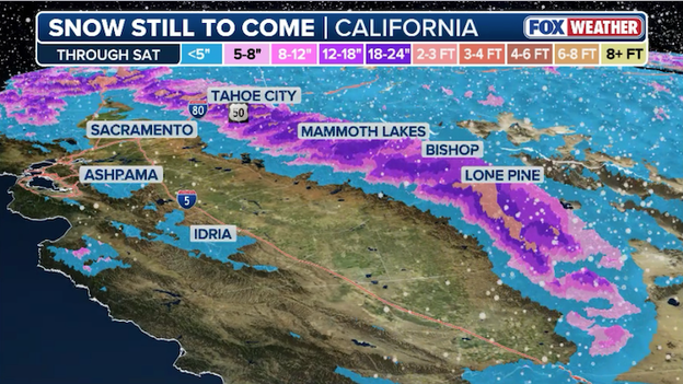
Latest snow forecast from FOX Weather showing heavy snow hammering the Sierra through Saturday.
The Sierra Nevada is getting no reprieve from this week’s historic weather as another wave of heavy snow is forecast to hit Thursday.
This fast-moving storm is expected to deliver an additional 12-18 inches of accumulation, with ridges seeing up to 4 feet of additional snow.
Travel across the mountain passes remains extremely precarious. Interstate 80 remains closed this morning through the mountains as snow and wind hamper efforts to clear the road.
As the Sierra Avalanche Center warns of continued unstable snowpack and high-elevation hazards, officials are strongly discouraging non-essential travel through the summit until the system finally begins to taper off late Thursday night.
The catastrophic California avalanche on Tuesday occurred in the rugged backcountry of Castle Peak, a 9,110-foot summit located in the Donner Summit area of the Sierra Nevada, approximately 10 miles north of Lake Tahoe.
The slide specifically struck near the Frog Lake backcountry huts, a remote destination where a group of 15 people—consisting of 11 clients and four professional guides from Blackbird Mountain Guides—had been staying since February 15.
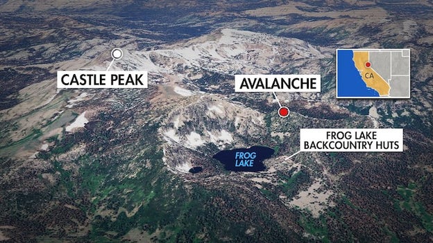
Map showing where the avalanche occurred near Castle Peak in California on Tuesday.
The incident happened around 11:30 a.m. PT as the group was traversing the steep, snow-laden terrain on their return journey to the trailhead at the end of a three-day excursion.
Experts say the disaster was triggered by a perfect storm of dangerous snowpack conditions and extreme weather. According to the Sierra Avalanche Center, the region was under a "high" avalanche warning due to rapidly accumulating new snow—falling at rates of up to 4 inches per hour—piling on top of a fragile, weak base layer created by unseasonably warm, dry weather in previous weeks.
Gale-force winds gusting over 100 mph further compromised the slopes, causing the "reloading" of snow in start zones and eventually triggering a massive slide, categorized as a D2.5 avalanche on a 5-point scale, which is typically the length of a football field and the depth of one floor in a house.
The sheer force of the event left nine members of the party missing, while six others managed to survive by huddling in a makeshift tarp shelter and using emergency beacons to alert dozens of first responders who battled blizzard conditions to reach them.
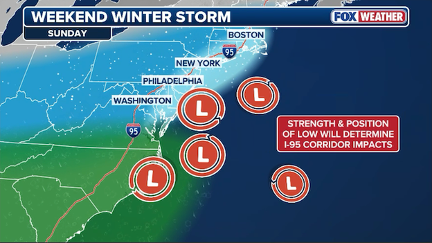
A potential nor'easter could threaten the Northeast with heavy snow and gusty winds late Sunday into Monday.
Meteorologists are track a potent low-pressure system with the potential to develop into a major nor'easter along the East Coast by Sunday.
This system is expected to originate from energy ejecting out of the Gulf and Southeast before tracking northeastward and potentially phasing with the northern jet stream. While the exact track remains subject to model shifts, current guidance suggests the storm could "bomb out" offshore, bringing a threat of heavy snow, coastal flooding, and gale-force winds to major metropolitan areas from the Mid-Atlantic through southern and eastern New England.
The timing of this potential nor'easter is particularly concerning as it follows a series of high-impact weather events across the country. Forecast models like the GFS have been more aggressive in developing a significant snow band across the Northeast, while the ECMWF has remained more conservative.
For residents in the Atlantic Corridor, this could mean a transition from unseasonably mild, wet weather earlier in the week to a shutdown scenario by Sunday night.
The FOX Forecast Center says cities like New York and Boston could see snow from this storm, but it's too early to determine exactly how much and where the heaviest will fall.
Travelers and residents are urged to monitor updates closely through the end of the week, as the exact "rain-snow line" will determine whether the I-95 corridor sees a heavy wintry mix or a full-scale snowstorm.
In addition to the threat of snow, the tightening pressure gradient from the intensifying storm is expected to generate significant wind gusts, which could lead to power outages and dangerous surf conditions along the coast.
The term "bomb cyclone" comes from the meteorological term "bombogenesis" or "explosive cyclogenesis." This happens when a storm system's central pressure drops at least 24 millibars within 24 hours.
For now, it's wait and see weather for millions along the heavily-populated I-95 corridor.
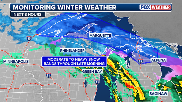
Heavy snow is expected to continue hammering the Upper Peninsula of Michigan this morning.
The FOX Forecast Center says heavy snow will continue to hammer Michigan's Upper Peninsula through the morning hours. These moderate-to-heavy snow bands are intensifying this morning, stretching from the Minnesota North Shore into the northern reaches of Lower Michigan.
Forecasters expect snow rates to commonly hit 1 to 2 inches per hour, though bursts of 2 to 3 inches per hour are possible along the volatile transition line where sleet and freezing rain shift to all snow.
This heavy snow is creating localized blizzard conditions, particularly along east-facing lake shores, where high winds and falling snow are severely restricting visibility.
The worst weather has been most persistent across the Keweenaw Peninsula and the North Shore. While southern Wisconsin and east-central Minnesota have seen mostly rain and isolated thunderstorms, this energy is transitioning rapidly to winter precipitation as it tracks across the Upper Great Lakes.
These dangerous conditions are expected to persist through the late morning before the intense pressure gradient relaxes, potentially allowing winds to decrease and visibility to improve slightly by midday.
Severe storms are expected to fire up across Illinois, Indiana, Ohio, and Kentucky on Thursday.
As the blizzard begins to wind down in the northern tier of the country, a new and dangerous threat is emerging for Thursday.
The same powerful low-pressure system that is paralyzing the Midwest will drag a potent cold front through the Mississippi and Ohio Valleys, where it will collide with warm, moisture-rich air from the Gulf of America.
This volatile atmospheric setup is expected to trigger numerous severe thunderstorms, shifting the national focus from snow and fire to the risk of damaging winds and tornadoes.
The FOX Forecast Center says it is particularly concerned about the potential for rotating storms that could spin up during the afternoon and evening hours. These storms may produce a few tornadoes and drop large hail across Illinois and Indiana.
As the storms continue to fire up through the afternoon, a squall line may develop and race eastward, producing 60-70 mph damaging winds.
Residents in the path of this shifting storm should ensure they have multiple ways to receive weather alerts throughout the day tomorrow, as the transition from winter weather to severe thunderstorms is expected to be swift and intense.
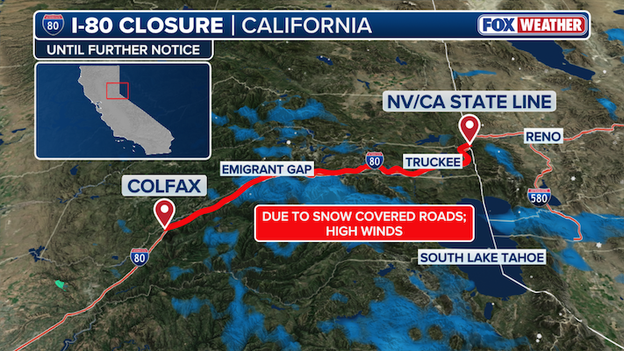
Interstate 80 remains closed through the Sierra due to intense snow and high winds.
Interstate 80 remains closed to all traffic this morning between Colfax and the California/Nevada state line as a historic winter storm continues to pummel the Sierra Nevada.
Caltrans and the California Highway Patrol have suspended all travel through the 60-mile corridor due to near-zero visibility, intense snow rates of 3 inches per hour, and multiple spinouts that have overwhelmed plow crews.
There is currently no estimated time for reopening, as the UC Berkeley Central Sierra Snow Lab reports this is the most powerful storm to hit the region since February 2023.
Drivers are strictly advised to avoid the area and use QuickMap.dot.ca.gov for real-time updates.
High winds, dry air, and abundant "fuel" created the perfect ingredients for Tuesday's wildfire outbreak in the Plains.
The catastrophic wildfire outbreak that scorched over 145,000 acres across the Plains on Tuesday, was the result of a rare and violent alignment of meteorological factors.
- The atmospheric setup: A powerful 125 mph jet stream aloft combined with a deepening surface trough east of the Rockies. This created intense downslope winds (compressional warming) that sent temperatures soaring into the 70s and 80s—unusually warm for mid-February.
- The humidity crash: As this air descended the mountains, it dried out aggressively. Relative humidity values plummeted into the single digits (below 10%) across eastern Colorado, western Kansas, and the Oklahoma Panhandle.
- The fuel load: Because much of the region has lacked consistent snow cover since November, the fine fuels—primarily dormant winter grasses—acted as kindling.
- Powerful wind gusts: Wind gusts of 60 to 70 mph acted as a blowtorch, turning small sparks from power lines or equipment into explosive fires that traveled miles in minutes, jumping highways like U.S. 283 and U.S. 64.
While the 'extreme' (Level 3 of 3) threat peaked on Tuesday, conditions remain perilous. Very dry air remains locked over the region, driving down humidity levels between 10% and 20% again today for much of the High Plains and extending into the Midwest.
The FOX Forecast Center is monitoring the Midwest for increasing fire danger today. Chicago and northern Illinois are currently under rare mid-February Fire Weather Warnings and Watches as 40 mph gusts and 15% humidity create a risk for rapid fire spread in areas with dry surface conditions.
With nearly half of the U.S. currently in drought, the National Interagency Coordination Center warns that the threat will likely persist through early March until the landscape begins to green up.
The Oklahoma Department of Emergency Management has confirmed to FOX Weather that four firefighters were injured on Tuesday while responding to the massive Ranger Road Fire in Beaver County.
FOX Weather has learned that the four firefighters were transported to area hospitals for treatment.
This morning, the Ranger Road Fire has now exploded to an estimated 145,000 acres across Oklahoma and Kansas, these injuries highlight the extreme risk crews are facing in 70 mph wind gusts.
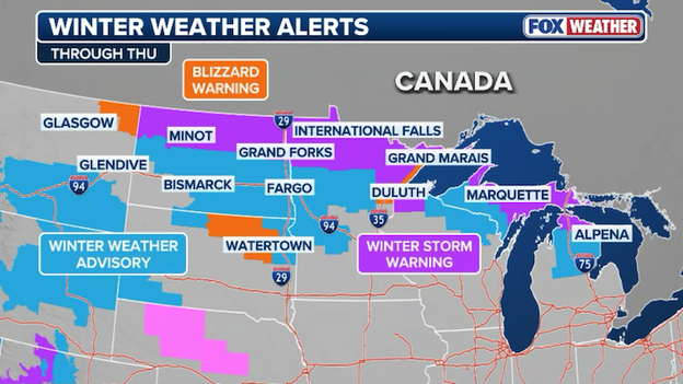
Blizzard Warnings and Winter Storm Warnings cover the Northern Tier of America.
A massive winter storm stretching over 1,000 miles is currently paralyzing the Northern Tier of the U.S., bringing life-threatening blizzard conditions to a swath from eastern Montana through North Dakota and into Northern Minnesota.
The National Weather Service has issued Blizzard Warnings for these regions as a deep low-pressure system delivers a dangerous combination of heavy, wet snow and hurricane-force wind gusts topping 60 mph.
The impact is expected to be most severe along Minnesota’s North Shore, which is bracing for a "shutdown" event with snow totals forecast between 12 and 24 inches. With snow falling at rates of over an inch per hour and visibility dropping to near zero, travel has become difficult to impossible.
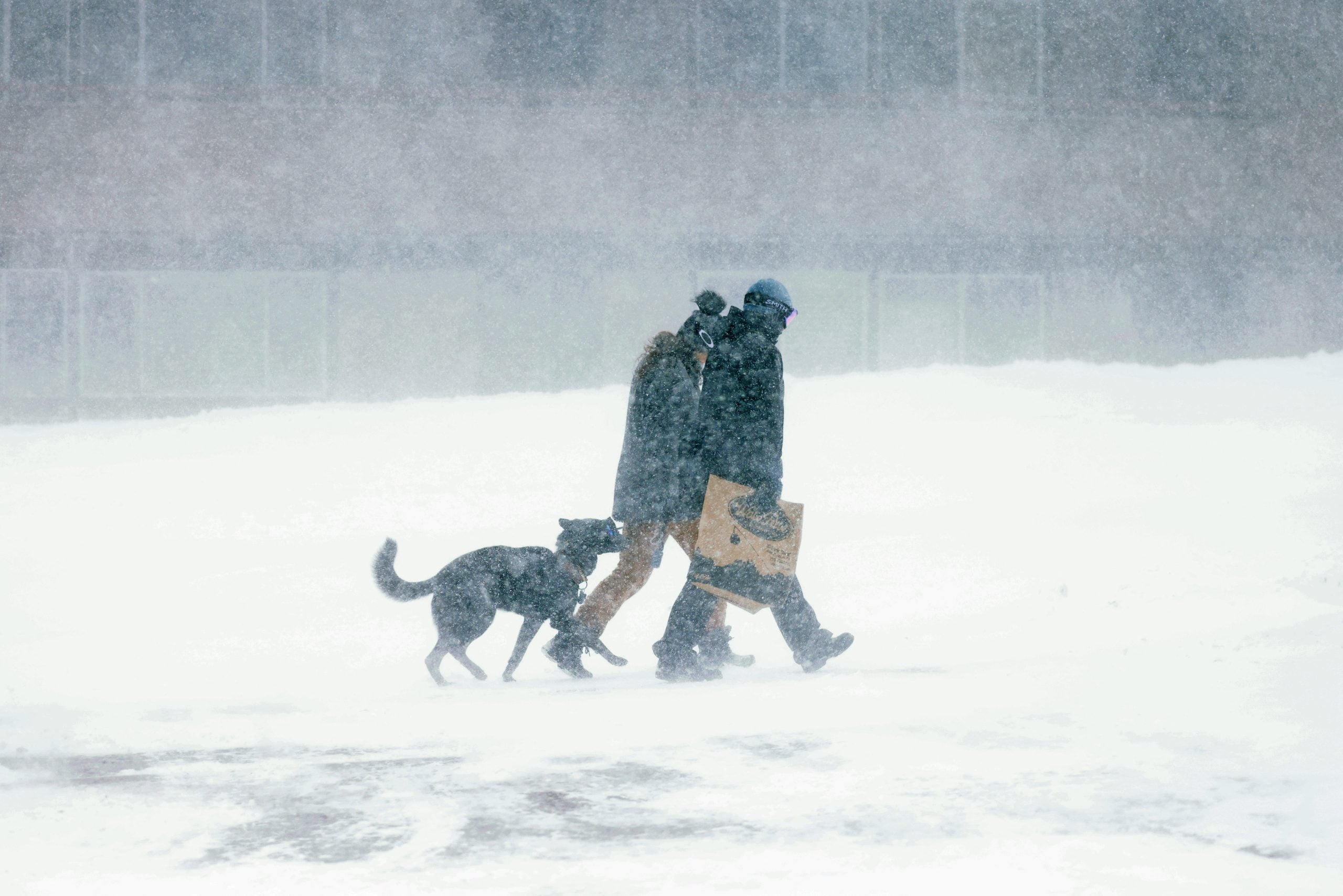
Officials across the Northern Tier are urging residents to stay off the roads, as these whiteout conditions—combined with plunging temperatures—create a high risk for those who become stranded.
As this storm continues to trek east, winter weather alerts now extend into the Upper Peninsula of Michigan, where an additional 8 inches of snow is possible through Thursday.
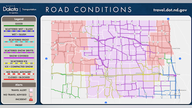
North Dakota Department of Transportation has issued 'No Travel' Advisories for parts of the state.
The North Dakota Department of Transportation (NDDOT) and the State Highway Patrol have issued No Travel Advisories for the northeast and northwest corners of the state.
Intense blowing snow is creating near-zero visibility, making road conditions extremely hazardous.
In addition to these advisories, travel alerts are currently in effect for central counties across North Dakota. While travel is still permitted in these areas, motorists should be prepared for rapidly changing conditions, slippery surfaces, and reduced visibility.
Officials urge drivers to take these warnings seriously, as those who venture out in "No Travel" zones risk becoming stranded, and emergency responders may not be able to reach them safely.
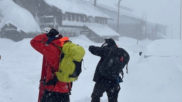
A massive rescue operation is entering a critical phase this morning near Castle Peak, California as first responders search for nine backcountry skiers still missing after a powerful avalanche.
The incident occurred around 11:30 a.m. Tuesday when a group of 15 people—identified as 11 clients and 4 professional guides—was caught in the slide near Frog Lake.
While six members of the party were successfully rescued late Tuesday night after sheltering in place under makeshift tarps, nine individuals remain unaccounted for.
Two of the survivors were transported to a local hospital with varying injuries.
The Nevada County Sheriff's Office revised the total group size down to 15 after initially believing 16 people were involved.
Nevada County Sheriff's Office says search and rescue operations continue to find 9 missing skiers in California. (Source: Facebook)
The FOX Forecast Center says search and rescue teams are battling "impossible" conditions as a relentless winter storm continues to pummel the Sierra Nevada. Heavy snow and wind gusts over 100 mph on Sierra ridges have severely limited visibility, grounding air support and making ground movement slow and tedious.
Interstate 80 remains closed at Donner summit, and major passes are impassable as crews work to clear feet of fresh accumulation.
The Sierra Avalanche Center warns that "high" danger persists through Wednesday, with unstable snow layers making human-triggered slides very likely.
The Sheriff’s Office is coordinating with dozens of responders from multiple agencies, including specialized ski teams from Boreal and Tahoe Donner.
You can go back and see LIVE updates from Tuesday's coverage.
Click here to see the minute-by-minute updates from FOX Weather.
You’ve reached the beginning of this live coverage.