Live updates: Severe storms slam East Coast, historic blizzard paralyzes Midwest
Live updates: Severe storms slam East Coast, historic blizzard paralyzes Midwest
Download the AppAnalysis: Why the rare East Coast severe weather threat failed to become a major outbreak
View postCoverage for this event has ended.
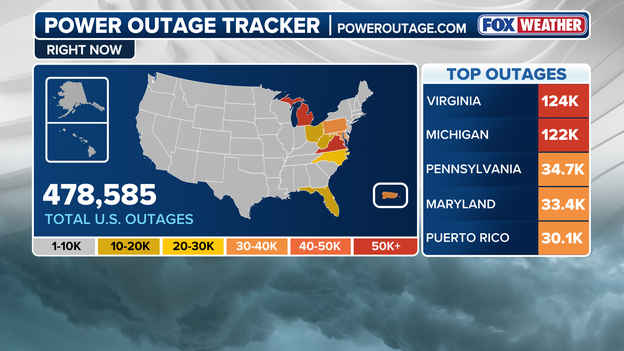
Latest power outage tracker showing significant outages across the U.S. (PowerOutage.com)
More than 452,000 customers are without power as severe weather slams the East Coast and a massive blizzard overwhelms the Upper Midwest.
Both Virginia and Michigan each have more than 122,000 outages, as major weather events continue to impact those regions. Pennsylvania is also seeing significant disruptions, with more than 35,000 outages.

Meanwhile, a life-threatening blizzard wraps up after unleashing feet of snow and vicious winds across the Midwest. At the same time, the Mid-Atlantic is experiencing heavy rain, thunderstorms and the potential for tornadoes.
Earlier this week, the Storm Prediction Center issued a rare Level 4 of 5 risk for severe weather. However, the anticipated storm system failed to deliver the widespread destruction many feared.
Warning Coordination Meteorologist with the Storm Prediction Center, Evan Bentley, joins FOX Weather to discuss the severe weather threat and why the outbreak didn’t fully materialize.
Damaging wind gusts reported in the Mid-Atlantic.
While Tornado Watches ended up getting canceled Monday evening, damaging wind was still reported across the highest risk areas.
The second round of storms along the cold front provided a majority of the damaging wind.
Wind gusts topping 60 mph were reported in the Washington, D.C. area. This kind of wind can cause trees and large branches to fall, along with power outages and road closures.
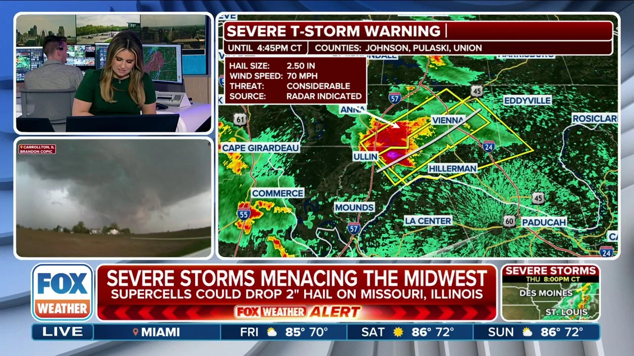
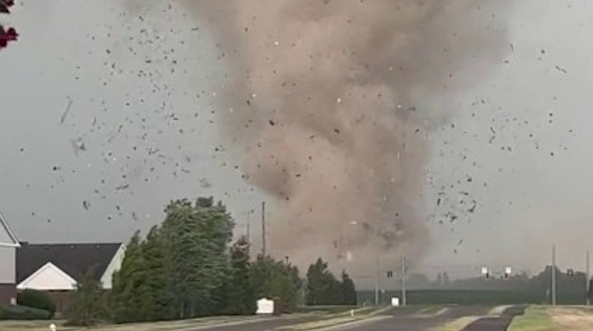
The National Weather Service said six tornadoes occurred in central Illinois on Sunday during a severe weather outbreak.
The tornadoes ranged from EF-0 to EF-1, producing wind gusts of up to 90 mph.
The storms caused damage to several structures and trees throughout the region.

The severe weather comes just days after Kankakee, Illinois, and surrounding areas were struck by a deadly tornado that unleashed grapefruit-size hail, torrential rain and left a trail of destruction in its path.
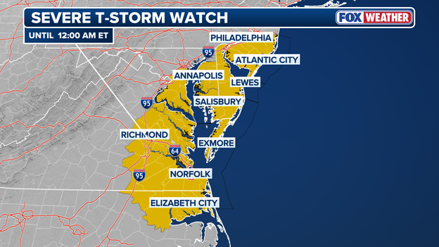
Severe Thunderstorm Watch issued for parts of the Mid-Atlantic
The National Weather Service issued a Severe Thunderstorm Watch for Washington D.C. through 12:00 a.m. ET.
Other areas that are part of this advisory include parts of Virginia, Delaware, southern New Jersey and Maryland.
Damaging wind gusts of 60 mph are expected, which may cause trees and large branches to fall, power outages and road closures.
A Tornado Watch was issued for the Washington D.C. area earlier tonight but was dropped.
There are still 36.6 million people under Tornado Watches spanning the East Coast.
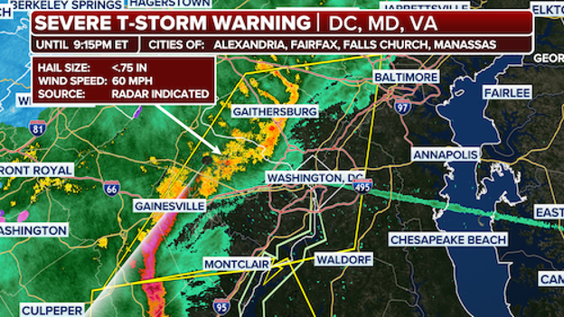
Severe Thunderstorm Warning issued for the Washington, D.C. area.
The Washington, D.C. area is under a Severe Thunderstorm Warning through 9:15 p.m. ET.
Wind gusts could top 60 mph and hail is also possible with this storm system.
A 66 mph wind gust was just recorded at Dulles International Airport.
The FOX Forecast Center said cities that could see impacts include Alexandria, Fairfax, Falls Church and Manassas.
A new Thunderstorm Watch has also been issued for the area through midnight.
The National Weather Service confirms that an EF-1 tornado touched down in the Mt. Pleasant/Columbia area on Sunday night.
The NWS determined that wind gusts reached 90 mph as the tornado tore through parts of South Carolina.
The tornado formed along Highway 43 in Mount Pleasant. Many trees were uprooted or had broken limbs, and a few homes and barns had metal roofing blown off, the NWS said.
The tornado continued into Columbia, impacting neighborhoods and Columbia State Community College. Tree damage and structural damage to homes was noted.
One building on the community college campus sustained roof damage, and fencing along the ball fields was also damaged, according to the NWS.
The tornado then reached an industrial area along Duck River where it uprooted many trees and tore the metal roofing off several buildings.
It then moved back into residential areas, causing downed trees, shingle and vinyl siding damage. The tornado was on the ground for 16.5 miles and was about 500 yards wide, according to the NWS.
A Tornado Watch that was in effect for the Outer Banks, North Carolina, area has been canceled.
It comes as the monster March storm largely failed to deliver widespread destruction many feared.
There are currently no more Tornado Watches issued.
Millions of Americans along the East Coast are breathing a sigh of relief as the monster March storm largely failed to deliver the widespread destruction many feared.
Despite over 120 reports of wind damage and a flurry of warnings across a half-dozen states, the day is ending without major damage.
The Storm Prediction Center says there have been over 120 reports of severe weather across more than a half dozen states on Monday.
Now, the FOX Forecast Center is breaking down why the rare threat never materialized.
One of the primary reasons Monday's rare risk failed to manifest as a historic outbreak was a meteorological phenomenon often called convective contamination.
Throughout the morning, a series of early-bird showers and thunderstorms developed well ahead of the primary cold front. These storms acted like atmospheric sponges, gobbling up the instability and moisture—or Convective Available Potential Energy (CAPE)—that the main line needed to turn violent.
By the time the cold front arrived, the air had been worked over, leaving the environment starved of the fuel necessary for explosive storm growth or long-track tornadoes.
This outcome highlighted a significant failure in the computer forecast models, which had struggled to predict just how much this early rain would stabilize the atmosphere. Most high-resolution models overestimated the daytime heating, failing to realize that thick cloud cover and early-morning rain would act as a shock absorber for the I-95 corridor.
Because the instability was so severely lacking, the atmosphere was never able to recover its energy, proving that even the most advanced simulations can still be blindsided by the complex way early-day storms pollute a severe weather environment.
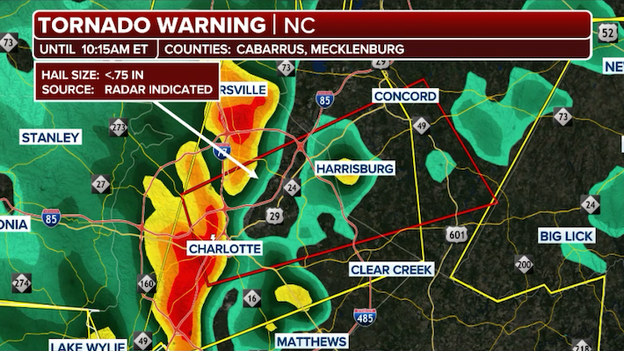
The National Weather Service confirms that an EF-0 tornado touched down in Charlotte, North Carolina, on Monday.
Charlotte-Mechlenburg Emergency Management said the tornado produced wind speeds of 85 mph, was on the ground for 1.5 miles and measured 25 yards wide.
"While today's storm has passed, we encourage everyone to remain prepared for future storms by making a plan, building a kit and signing up for CharMeck Alerts," the department said on social media.
Flights out of Fort Lauderdale and Miami are currently halted due to ongoing thunderstorms.
The FAA said the Fort Lauderdale/Hollywood International Airport, FLL, is grounded flights due to thunderstorms in the area.
There's also a ground stop at Miami International Airport, MIA, due to thunderstorms.

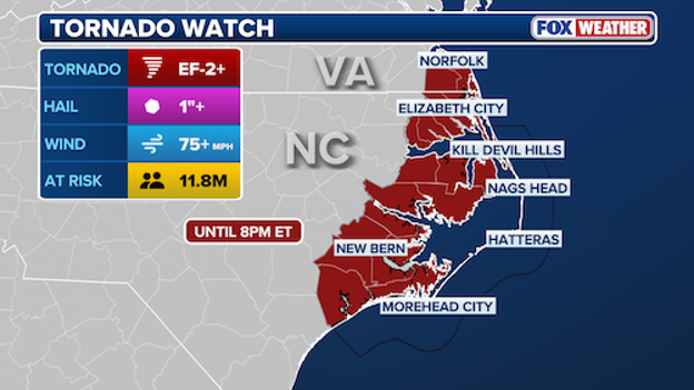
Tornado Watches remain in effect along parts of the North Carolina and Virginia coast.
Tornado Watches issued for the Philadelphia and Northeast have been dropped, but the Outer Banks is still at risk of seeing strong storms.
Potential EF-2+ tornadoes are possible through 8 p.m., and a Tornado Watch remains in effect along the coast of North Carolina and Virginia.
Nearly 12 million people are at risk, and wind gusts could top 75 mph.
The National Weather Service confirms an EF-1 tornado touched down in Bonnertown, Tennessee, late last night.
A storm survey team preliminarily determined that a tornado touched down in an open field west of Earnest Street and south of Highway 4 in Lexington, Alabama. The tornado caused an outdoor structure propped up on cinder blocks to slide, as well as uprooted trees, the NWS said.
Minor roof damage was reported to several structures, homes had siding damage, several small open structures collapsed and a garage door was blown in, according to the NWS.
Reports indicate that the tornado crossed the Tennessee-Alabama state line and moved Northeast, continuing for 10 more miles in Tennessee.
In Bonnertown, many homes were impacted, with several sustaining heavy damage. Other structural damage including missing awnings, removed shingles and carports thrown, was reported.
The storm continued east and destroyed a chicken farm roof before winding down in Minor Hill, according to the NWS.
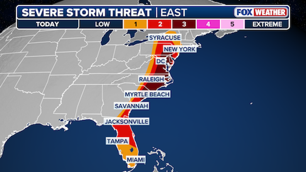
A Level 3/5 severe storm threat remains in effect for parts of the East Coast.
What was a Level 4/5 storm threat has now dropped to a Level 3/5 threat, according to the National Weather Service.
There is still a chance for strong EF-2+ tornadoes along the East Coast, with the Carolinas still being under the highest storm threat.
The Washington, D.C. area could still get strong winds, but the storm appears to be moving away from the area, according to the FOX Forecast Center.
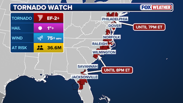
Tornado Watches in effect across the East Coast.
A Tornado Watch that was issued for the Washington, D.C. area tonight has been canceled.
The watch was set to remain in effect through 7 p.m., but has been since dropped.
There are still 36.6 million people under Tornado Watches spanning the East Coast. Strong tornadoes and 75+ mph wind gusts remain possible.
Paul Schloegel, commissioner and mayor of the City of Marquette, Michigan, joins FOX Weather to discuss the monster blizzard bombarding the city with feet of snow.
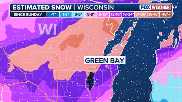
Green Bay sees second biggest snowfall on record.
The blizzard currently slamming parts of the U.S. has broken a record in Green Bay, Wisconsin.
The recent snowfall marks the biggest snowstorm in 136 years, with 26.1 inches recorded in the city as of 1 p.m.
On Sunday, the area recorded 17.1 inches and another 9 inches of snow fell today.
The biggest snowstorm the area has ever seen happened on March 1 and 2, 1888, when 29 inches of snowfall was recorded, according to the National Weather Service.
NWS said 26 inches is also nearly half, or 47%, of their average annual snow of 55.6 inches.
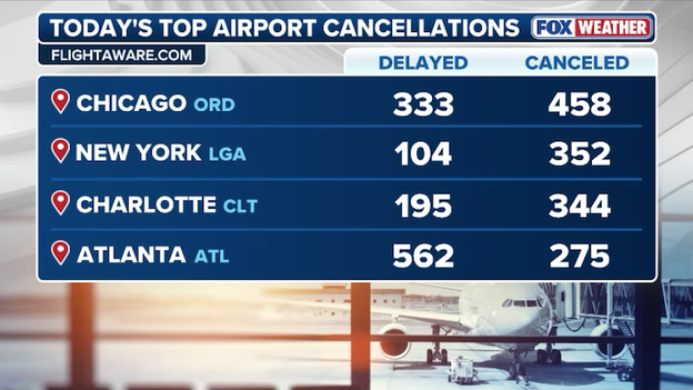
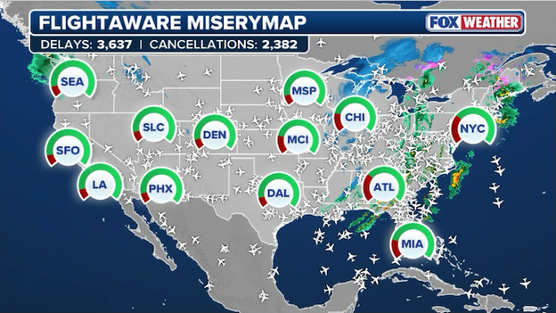
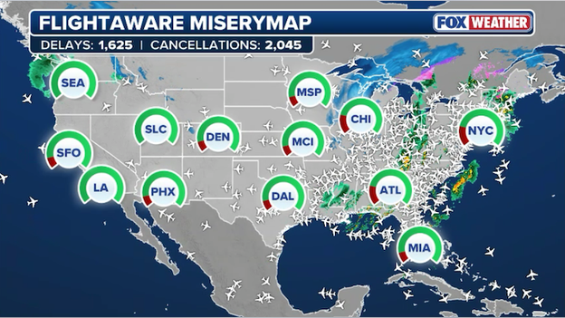
According to the latest data from FlightAware, total flight disruptions have now surged past 26,000 for the Sunday-through-Tuesday period.
This massive number includes 18,852 delays and 7,092 cancellations, leaving travelers stranded from the Pacific Northwest to the Atlantic coast.

FlightAware data shows hundreds of flight delays and cancellations at major U.S. hubs.
While the Midwest is still reeling from record-breaking snow, the primary source of today's gridlock has shifted to the I-95 corridor.
Severe thunderstorms roaring toward I-95 have forced the FAA to implement repeated ground stops at major East Coast gateways, including Dulles (IAD), Philadelphia (PHL), and Orlando (MCO).
With over 7,000 flights now completely wiped from the schedule, airlines are warning that recovery mode will be a multi-day process, as nearly every available seat is already booked for the peak spring break travel season.

Sleet spotted on windshields in North Georgia.
FOX Weather Storm Specialist Mike Seidel captured this scene of sleet bouncing off a windshield as freezing air begins to filter into the Peach State from the north.
These small, ice pellets are a clear signal of the dramatic temperature crash currently underway, as high-altitude freezing air overrides the lingering warmth at the surface.
This wintry mix is expected to continue through the afternoon for higher elevations, potentially creating slick spots on winding mountain roads and bridges.
With a hard freeze likely for much of the state tonight, this afternoon's sleet serves as a cold reminder that winter isn't finished
While the most dangerous weather is focused to the north, residents in Central and South Florida should still keep an eye on the sky this afternoon as scattered thunderstorms begin to pop up along the sea breeze.
The atmosphere across the peninsula is very warm and humid, providing plenty of fuel for these storms to grow quickly and potentially produce isolated large hail or damaging wind gusts.
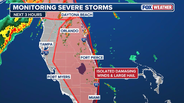
Forecasters are monitoring Central and South Florida for strong thunderstorms through the afternoon.
However, because the strongest steering winds are currently staying well to our north, these early storms aren't expected to organize into a major, widespread threat, and the Storm Prediction Center says it's unlikely that a Severe Thunderstorm Watch will be issued.
A second line of storms will move in from the Gulf later tonight, but forecasters expect it to lose much of its punch as it travels south, though they will continue to monitor the situation closely for any sudden changes.
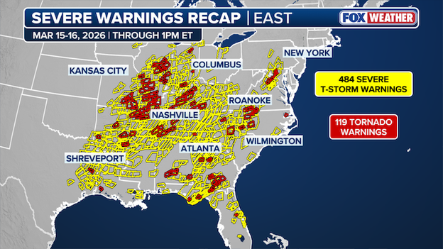
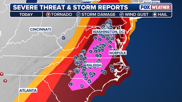
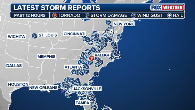
Map showing all the individual Tornado Warnings & Severe Thunderstorm Warnings issued in the past day.
Meteorologists at the National Weather Service have been very busy over the past 24 hours as severe storms erupted across the eastern half of the nation.
Data shows nearly 600 severe weather warnings (Tornado Warnings & Severe Thunderstorm Warnings) have been issued across 22 states in the past day.
These warnings are used to alert Americans to dangerous weather before it hits and urge people to take action to protect life and property.
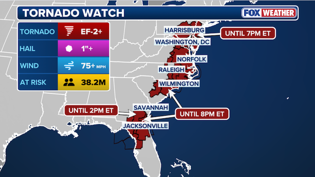
The Storm Prediction Center has issued Tornado Watches for nearly 40 million Americans.
Nearly 40 million Americans are on high alert this afternoon as the monster March storm takes aim at the nation's most densely populated corridors.
Tornado Watches now cover most of the I-95 corridor from New Jersey to Florida.
A Tornado Watch is now in effect for parts of North Florida and extreme Southeast Georgia until 8:00 p.m. ET.
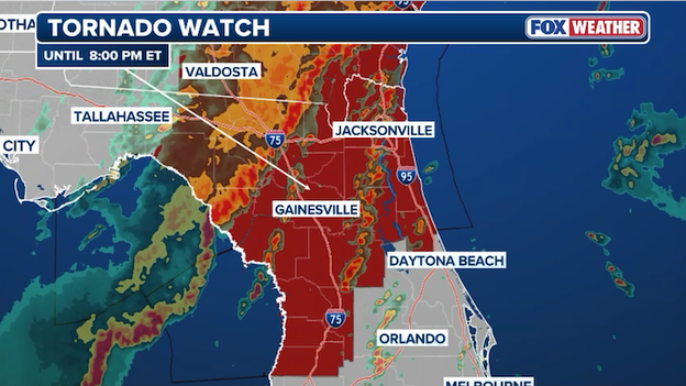
A Tornado Watch has been issued for North Florida and extreme Southeast Georgia until 8:00 p.m. ET.
As a powerful cold front charges east, it is pushing a line of intense thunderstorms across the Gulf Coast, bringing the threat of tornadoes, damaging wind gusts up to 60 mph, and isolated hail.
The watch currently covers several northern counties—including the Jacksonville metroand Gainesville—through early evening.
Behind this front, temperatures are expected to plummet, with a hard freeze possible for inland areas by Tuesday morning.
When a severe storm tears through a neighborhood, the immediate question is almost always, "Was it a tornado?" While tornadoes are the most famous face of severe weather, National Weather Service survey teams often find that the culprit was actually a powerful downburst or straight-line winds.
The easiest way to tell the difference is to look at the debris: a tornado acts like an inhaler, sucking air inward and spinning it, which leaves a chaotic, circular mess where trees may be pointing in several different directions.
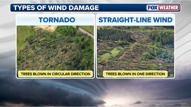
Damage patterns help reveal whether a tornado or straight-line winds are to blame.
In contrast, straight-line winds act like an exhaler, occurring when rain-cooled air crashes to the ground and spreads out, mowing down trees in parallel rows like a box of spilled toothpicks.
It is a common myth that a "twisted" tree trunk proves a tornado occurred. In reality, because trees are naturally asymmetrical, a blast of straight-line wind hitting one side of a canopy more than the other can cause the trunk to twist and snap even without a rotating funnel.
Don't let the lack of a twister label fool you, though; straight-line winds can easily exceed 100 mph, matching the power of an EF-1 tornado. And straight-line winds can be more widespread than the damage from a single tornado.
FOX weather meteorologists say the survival strategy remains identical: get to the lowest floor of a sturdy building, stay away from windows, and protect your head.

Spring break is off to a chaotic start for thousands of travelers as the monster March storm continues its destructive path across the United States.
According to the latest FlightAware data, the total number of flight disruptions for the Sunday-through-Tuesday period has now surged past 24,000. The staggering breakdown of the meltdown includes over 17,200 delayed flights and more than 6,960 cancellations.

FlightAware MiseryMap showing the total flight disruptions across America.
What began as a historic blizzard in the Midwest—burying hubs like Minneapolis-St. Paul (MSP) and Chicago O'Hare (ORD) in record snow—has now evolved into a high-impact severe weather event for the East Coast.
Ground stops and delays have been rolling through major gateways like Atlanta (ATL), Charlotte (CLT), and Dulles (IAD) all day, while high winds are currently clobbering the Philadelphia and New York regions.

With 6,900+ flights completely removed from the schedule and airlines already operating at near-capacity for spring break, the ripple effect of these disruptions is expected to last well into the weekend.
Travelers are being urged to download their airline's app for the fastest rebooking options, as wait times for phone support have reportedly climbed to over four hours for several major carriers.
The main event of today's Level 4 severe weather outbreak is fast approaching the I-95 corridor. While we have seen scattered storms throughout the morning, the primary squall line is expected to tap into peak daytime heating this afternoon, turning into a high-speed wall of wind as it moves toward the coast.
The critical windows
Because these storms will be moving northeast at a staggering 60 mph, your window to react will be small. Here is the estimated timing for the arrival of the most dangerous wind and tornado threats:
- Washington, D.C. & Northern VA: 3:00 p.m. – 6:00 p.m. ET
- Baltimore & Central Maryland: 4:00 p.m. – 7:00 p.m. ET
- Philadelphia & Harrisburg, PA: 5:00 p.m. – 8:00 p.m. ET
- New Jersey & New York City: 7:00 p.m. – 10:00 p.m. ET
- Delaware & Eastern Shore: 6:00 p.m. – 9:00 p.m. ET
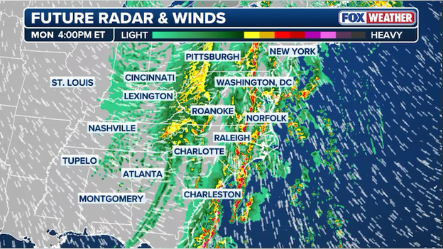
High-resolution computer forecast models show severe storms charging east along I-95 later this afternoon.
Evening commute impact
The most intense weather is timed almost perfectly to hit during the evening commute.
Local officials in Maryland and Virginia have already dismissed many schools early to avoid having buses on the road during the peak of the 80-mph wind threat.
If you are in the I-95 corridor, you should aim to be at your safe destination before 4:00 p.m. ET.
Herman, Michigan, has reported a staggering 36.0 inches of total snow over the last 48 hours, it’s the pace of the storm that has climatologists buzzing: 34.0 inches of that snow fell within a single 24-hour window.
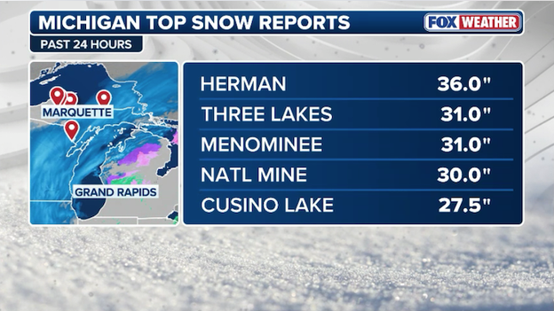
Latest top snow reports from Michigan.
To put this in perspective, Michigan’s current official 24-hour snow record is 32.0 inches, set in this very same town of Herman back in December 1985 (though some unofficial reports of 30 inches from 1996 often cite the same area).
If the National Weather Service verifies this 34-inch report, it will officially become the greatest one-day snow in Michigan's history.
For the residents of Baraga County, this isn't just a statistic—it’s a total emergency. With nearly three feet of snow falling in a day, combined with 50-mph winds, the Upper Peninsula is facing impossible travel conditions as drifts likely bury entire vehicles and first-floor windows.
A historic blizzard is slamming the Midwest with millions in the threat zone.
FOX Weather Correspondent Robert Ray is reporting live from Marquette, Michigan with the latest.
The massive March storm has saved its most shocking twist for the Deep South: snow is slamming Birmingham and parts of Central Alabama right now.
While residents were dodging Tornado Warnings just 12 hours ago, they are now watching large, wet snowflakes fall as a powerful Arctic front completes its takeover.
Weatherstem camera in Birmingham, Alabama.
Because the ground remains warm from recent 70-degree days, accumulation is mostly limited to grass and rooftops, but the intensity of the flurries has been enough to create a surreal winter wonderland against a backdrop of spring blooms.
Due to the sudden increase in snow, the National Weather Service has issued a last-minute Winter Weather Advisory for portions of Northern Alabama and Southern Tennessee.
Forecasters are warning that while widespread accumulation isn't expected, a quick dusting on bridges and overpasses could create treacherous slick spots for the midday commute.
This advisory joins a high-priority Freeze Warning already in place for tonight, as temperatures are expected to bottom out in the mid-20s across the region.
According to the latest data from FlightAware, the total number of flight disruptions is rapidly approaching a staggering 23,000 for the Sunday-to-Tuesday travel window.
As of midday Monday, the tally includes 16,079 delayed flights and 6,792 cancellations, as a dual-threat of blizzard conditions in the Midwest and violent thunderstorms in the East continues to overwhelm the U.S. air traffic network.
FlightAware MiseryMap showing the total flight disruptions at major airport hubs across the U.S.
The pressure is now centered squarely on the East Coast. Ground stops have cycled through major hubs like Atlanta (ATL) and Charlotte (CLT) all morning, and a fresh ground stop was recently issued for Washington Dulles (IAD).
Even as storms clear some cities, massive backlogs and highs winds behind the main storm are keeping aircraft grounded.
With Spring Break travel at its peak, airlines are struggling to find open seats for the thousands of passengers displaced by the 6,700+ cancellations, leading to warnings that it could take until late in the week for normal operations to resume.
Severe storms are currently tracking through the Maryland suburbs just north of Washington, D.C.
A Tornado Warning is in effect until 12:15 p.m. ET for portions of Carroll and Howard Counties, as a severe thunderstorm capable of producing a tornado races through the region.
Radar showing the Tornado Warning just north of Washington D.C.
This fast-moving storm is part of the broader threat that is currently battering the Mid-Atlantic with damaging winds and intense rain.
Additional storms are expected to fire up across the region this afternoon and a Tornado Watch remains in effect until 7 p.m.
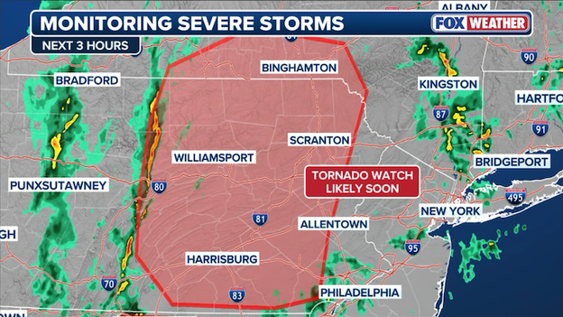
The Storm Prediction Center has expanded the Tornado Watch to include the densely populated I-95 corridor.
The watch now covers Philadelphia and Harrisburg, Pennsylvania; Dover, Delaware; and Atlantic City, New Jersey.
A Tornado Watch has been issued for Philadelphia and along I-95.
Right now, forecasters are most concerned with severe storms producing damaging winds gusts to 80 mph.
The northern edge of this life-threatening weather system is now just 20 miles south of New York City.
While the Five Boroughs are currently under a Wind Advisory and Flood Watch, the rapid expansion of this watch suggests that the atmospheric energy is holding together much further north than originally anticipated.
Residents from the Jersey Shore up to the Hudson Valley should be prepared for power outages and downed trees as these storms move at highway speeds, often arriving with less than 15 minutes of warning.
Forecasters at the Storm Prediction Center are closely monitoring a line of showers across Pennsylvania right now.
That line is expected to strengthen in the hours ahead and the severe weather threat will increase across the region.
Meteorologists are closely monitoring an intensifying line of showers across Pennsylvania right now.
The SPC says it will likely issue a Tornado Watch if conditions warrant it later today.
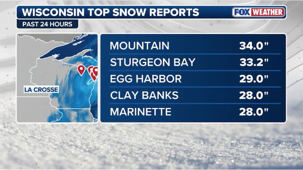
The ongoing March blizzard is more than just a major storm—it is a legitimate run at the history books. As of Monday morning, preliminary reports suggest that Wisconsin may have just witnessed its snowiest 48-hour period in recorded history.
Leading the charge is Mountain, Wisconsin, where a staggering 34.0 inches was reported via a local broadcast station. Close behind is Sturgeon Bay with a massive 33.2-inch total.
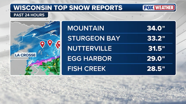
Latest top snow totals from across Wisconsin.
To put these numbers in perspective, the current all-time state record for a two-day snowfall is 33.0 inches, set in Iron County nearly 20 years ago in April 2007.
If these new totals are verified, this storm will officially become the new benchmark for extreme winter weather in the Badger State.
- Current 2-day record: 33.0" (Iron County, April 3–4, 2007)
- Potential new record: 34.0" (Mountain, WI, March 15–16, 2026)
- 24-Hour record in jeopardy: The 1904 record of 26.0" (Neillsville) is also being challenged by several stations reporting over two feet in a single calendar day.

These totals are currently preliminary. The State Climate Extremes Committee must now conduct a meticulous verification process—which can take months—to ensure the measurements were taken correctly and weren't inflated by snow drifting before they are officially etched into the record books.

The Storm Prediction Center has issued a Tornado Watch for Washington DC until 7:00 p.m. ET.
A Tornado Watch has been issued for Washington, D.C., and much of the surrounding Mid-Atlantic region until 7:00 p.m. ET as a rare severe weather outbreak threatens the area.
The watch is in effect as a powerful squall line begins to tap into record-high atmospheric energy, creating a volatile environment capable of producing tornadoes, large hail, and destructive straight-line winds exceeding 80 mph.
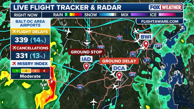
A ground stop has been issued for Washington Dulles International Airport until 11:45 a.m. ET.
A ground stop has been issued for Washington Dulles International Airport (IAD), halting inbound traffic until 11:45 a.m. ET.
This specific freeze is targeted solely at flights departing from airports along the East Coast.
The restriction comes as the leading edge of a powerful cold front begins to squeeze the I-95 corridor, bringing heavy rain and increasing wind shear that is complicating the final approach for regional arrivals.
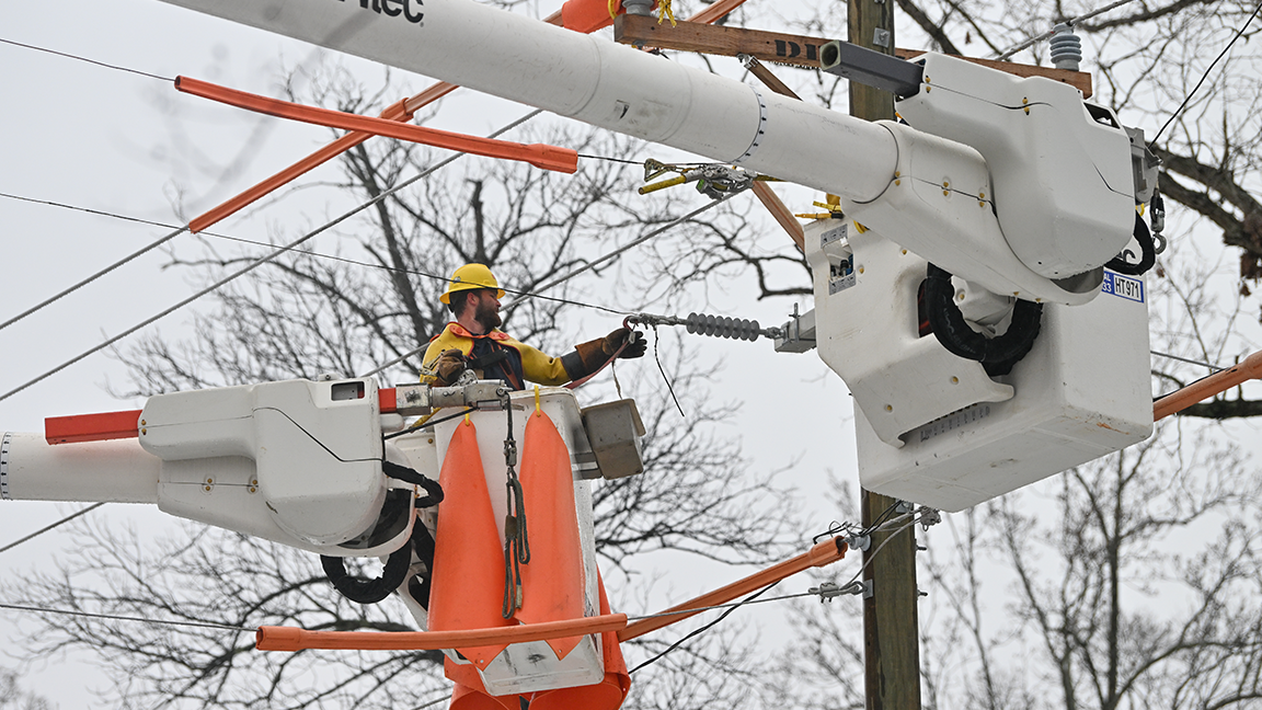
The monster March storm continues to take a heavy toll on the nation's power grid. As of late Monday morning, more than 443,000 customers are without power across the eastern half of the U.S.
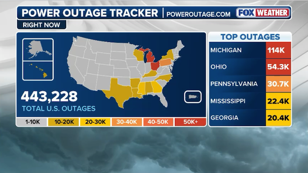
PowerOutage.com reports more than 443,000 customers are without power right now.
While utility crews have made some progress in certain regions, the combination of heavy, wet snow in the Great Lakes and high-velocity winds in the South is keeping outage numbers at critical levels.
Michigan remains the epicenter with 114,000 outages, as blizzard conditions continue to strain the local infrastructure. Ohio is also seeing significant disruptions with 54,300 customers in the dark.
Meanwhile, as severe storms push toward the coast, states like Pennsylvania (30.7K), Mississippi (22.4K), and Georgia (20.4K) are reporting widespread line damage from falling trees and intense gusts.
With the storm system now targeting the densely populated I-95 corridor, emergency management officials are warning residents to prepare for additional interruptions through the afternoon.
Amid a historic blizzard impact million in the Midwest, FOX Weather Exclusive Storm Tracker Brandon Copic is LIVE in Green Bay, Wisconsin where emergency crews are battling a huge fire.
Extreme weather has crippled the nation’s airways, with flight disruptions soaring past a critical milestone this morning.
According to the latest data from FlightAware, more than 21,100 flights have been impacted between Sunday and Tuesday as the aviation industry struggles with a historic Midwest blizzard and a violent squall line tearing through the East Coast.
FlightAware data shows hundreds of flights have been canceled today in Chicago, New York, and Atlanta.
The numbers tell a staggering story of a system under siege: 14,761 delays have left millions waiting in terminals, while 6,350 cancellations have completely wiped flights from the boards.
While hubs like Chicago O’Hare (ORD) and Minneapolis-St. Paul (MSP) are still dealing with the Midwest blizzard, the pressure has shifted to the South and Mid-Atlantic.
Severe winds and thunderstorms have triggered rolling ground stops today at Atlanta (ATL), Charlotte (CLT), and Houston (IAH), creating a massive logistical backlog that is expected to ripple through the entire work week.
The Midwest blizzard is cementing its place in the history books this morning, with Three Lakes, Michigan, reporting a staggering 31.0 inches of snow. This nearly three-foot snow total comes within an inch of Michigan's long-standing 24-hour snow record of 32.0 inches, which was previously set in Herman back in December 1985.
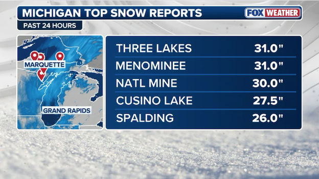
Latest top snow reports from Michigan.
The Upper Peninsula is currently the epicenter of the storm's fury, where lake-enhanced moisture is dumping snow at impossible rates.
For residents in Three Lakes and the surrounding Baraga County, the sheer volume of snow combined with 50-mph wind gusts has made the region a total whiteout zone.
With 31 inches on the ground, most secondary roads are completely buried, and local officials are warning that it may take days for crews to reach some isolated areas as the snow continues to drift.

Camera showing snowflakes flying in Jasper, Alabama.
In a stunning weather reversal, the same front that brought severe storms to the South yesterday is now ushering in snow flurries across Alabama.
As seen in local cameras this morning, large snowflakes are clearly visible falling over downtown squares, marking a rare March surprise for the Heart of Dixie.
While the ground remains relatively warm from recent spring-like temperatures, preventing major accumulation, the sight of snow falling against a backdrop of budding spring trees highlights the incredible temperature plunge currently sweeping through the Deep South.
A truly staggering amount of snow has been recorded in the Northwoods, with a massive 34.0 inches measured in Mountain, Wisconsin, as of Monday morning.
Latest top snow reports from Wisconsin.
This historic total currently stands as the highest snow report from the "March Mania" storm complex, highlighting the extreme nature of the blizzard that has paralyzed much of the Upper Midwest.
To put that in perspective, parts of Oconto and Marinette counties have seen nearly three feet of snow in a single event, leaving many residents completely snowed in as plows struggle to clear roads amid ongoing 45-mph wind gusts.
The severe weather threat is ramping up across Virginia and Maryland this morning as the massive March storm begins its final surge toward the East Coast.
The FOX Forecast Center is closely watching a process called moisture advection—think of it as a giant invisible river of humid air flowing in from the south. At the same time, air high above is cooling down. This combination is like adding fuel to a fire, making the atmosphere extremely unstable and ready to pop.
Radar shows storms developing across Virginia and Maryland with the severe weather threat increasing.
We are already seeing some scattered storms forming ahead of the main line. While these early storms are unorganized, they are a sign of things to come.
The real concern is the wind shear, which is a dramatic change in wind speed and direction as you go higher up. Forecasters have noted that this spin is strengthening rapidly.
If any of these morning storms can tap into that energy, they could quickly produce a tornado.
However, the biggest danger is expected later this afternoon when a jet streak—a pocket of high-speed winds in the upper atmosphere—arrives.
The Storm Prediction Center says it will issue a Tornado Watch for the area, including Washington, D.C., in the hours ahead.
The scale of the atmospheric collision currently hammering the United States has reached a staggering milestone in the skies.
According to the latest data from FlightAware , the number of flight disruptions has now surged past 20,000 for the Sunday-to-Tuesday travel window. As of 9:50 a.m. ET, the total includes 5,600+ outright cancellations and a massive 14,400+ delays, leaving millions of spring break travelers stranded across the country.
FlightAware MiseryMap showing total flight disruptions across the U.S.
The disruption is a perfect storm of logistical nightmares. While Minneapolis-St. Paul (MSP) and Chicago O'Hare (ORD) struggle to recover from 20-inch snowfalls and whiteout conditions that saw nearly 75% of flights canceled yesterday, the East Coast is now bearing the brunt.
Severe storms have triggered repeated ground stops this morning at Atlanta (ATL) and Charlotte (CLT), while high winds have forced a ground delay program at Houston (IAH).
With rebooking options nearly non-existent due to high spring break volume, airlines like Delta and United are warning that the ripple effect of these 20,000 disruptions will likely extend through the remainder of the work week.
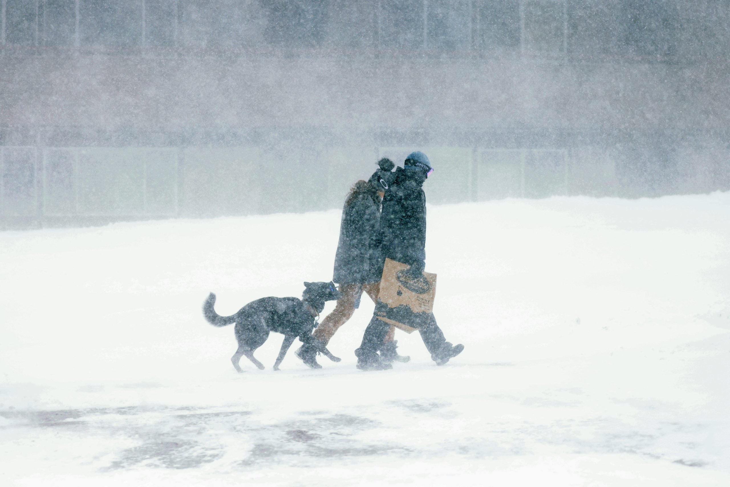
A life-threatening situation is unfolding as a monstrous blizzard is unleashing feet of snow and vicious wind gusts throughout the Upper Midwest and Great Lakes.
More than 2 feet of snow has fallen in Wisconsin and Michigan since Sunday, with potentially historic accumulations expected in the Upper Peninsula.
FOX Weather Correspondent Robert Ray has the latest conditions in Marquette, Michigan.
The March blizzard isn't done with the Midwest just yet. Forecasters are currently tracking a concentrated band of heavy snow stretching from eastern Wisconsin up into Michigan’s Upper Peninsula.
According to recent weather balloon data and radar imagery, the clouds in this corridor are packed with moisture and the air is cold enough to dump snow at a rate of 1 to 2 inches per hour through the rest of the morning.
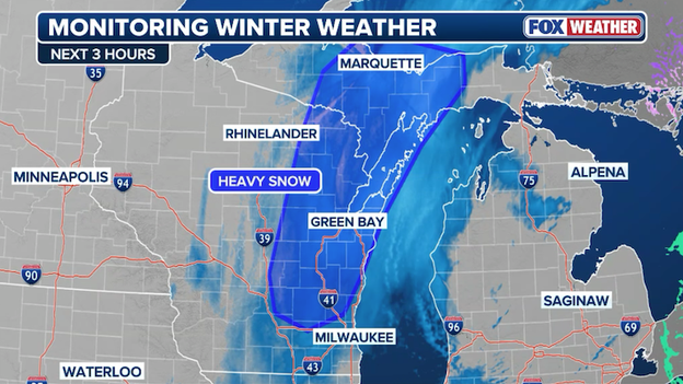
Radar showing a band of heavy snow across eastern Wisconsin and Upper Michigan.
The real danger, however, isn't just the falling snow; it’s the wind. Powerful gusts are hitting these same areas, whipping the fresh snow into the air and creating ground blizzards.
This means that even if the snow slows down, the visibility on the roads can drop to near-zero in an instant.
If you are traveling along the I-43 or I-41 corridors in Wisconsin or anywhere in Upper Michigan, expect extremely dangerous driving conditions and "whiteout" visibility through the midday hours.
The combined force of a record-breaking blizzard and a severe weather outbreak has left nearly 485,000 customers without power across the eastern half of the United States.
According to the latest data from PowerOutage.com, the total number of outages has surged to 484,229, with the most significant damage concentrated in the Great Lakes and the Southeast.
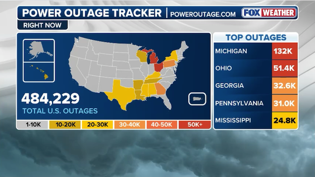
More than 484,000 customers are without power across the United States this morning.
Utility crews are facing a multi-front war, battling both whiteout conditions in the North and destructive squall lines in the South.
Michigan remains the hardest-hit state by far, with 132,000 customers in the dark as heavy, wet snow and 50-mph winds continue to snap limbs and bring down lines.
Farther south, the severe storms that triggered morning Tornado Warnings is taking its toll, with Georgia (32.6K) and Mississippi (24.8K) reporting widespread outages from wind damage.
As the severe storm threat shifts into the densely populated I-95 corridor this afternoon, officials warn that these numbers are likely to climb higher before the front finally clears the coast tonight.
A Tornado Warning has been issued for Charlotte, North Carolina.
A Tornado Warning has been issued for Charlotte and surrounding Mecklenburg County as a violent line of thunderstorms moves through the North Carolina Piedmont.
This dangerous storm, capable of producing a tornado and damaging 60-mph wind gusts, is part of the rare severe storm outbreak that forecasters have been tracking for days.
Residents in the path of this storm—including those in Uptown, South End, and University City—need to move to a basement or an interior room on the lowest floor immediately.
The warning comes as several Charlotte-area school districts have already shifted to virtual learning or closed for the day to keep students off the roads during the most volatile window of weather.
Because these storms are moving northeast at a staggering 60 mph, there is almost no time to react once a warning is issued.
Stay away from windows, abandon mobile homes for sturdier shelter, and keep your phone’s ringer on loud to receive life-saving alerts until the threat passes later this afternoon.
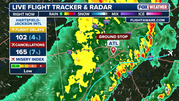
Hartsfield-Jackson Atlanta International Airport (ATL) is under a new ground stop this morning, with the FAA halting inbound traffic until 10:00 a.m. ET.
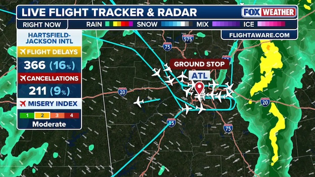
Delays and cancellations are stacking up at Hartsfield-Jackson Atlanta International Airport.
While the primary line of severe storms has already pushed east of the city, the ripple effect of the morning’s volatile weather is still paralyzing operations.
For the thousands of spring break travelers caught in the shuffle, this extension means even more time spent waiting at departure gates across the Southeast.
Officials are warning that even after the 10:00 a.m. freeze is lifted, the additional delay programs will likely remain in place for hours as America's busiest airport attempts to untangle the logistical knot.
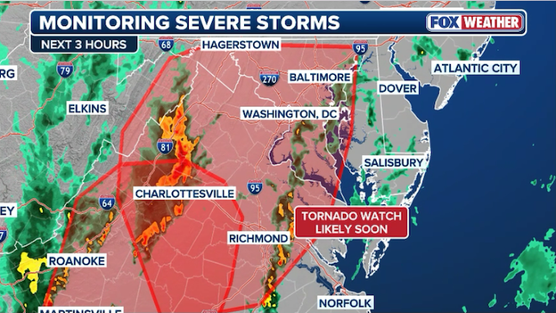
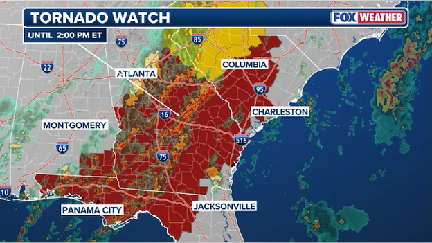
A fresh Tornado Watch has been issued for a large swath of Virginia and North Carolina as the East Coast prepares for a rare severe storm outbreak.
In effect until 2 p.m. ET, the watch covers major population centers including Roanoke and Raleigh area.
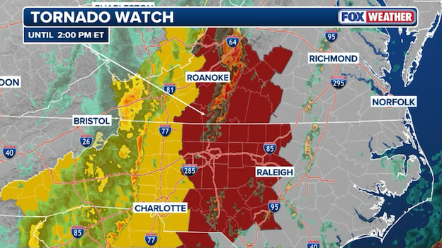
A new Tornado Watch has been issued for portions of Virginia and North Carolina until 2 p.m. ET.
Forecasters are warning that today’s atmospheric spin is extremely high, meaning fast-moving thunderstorms could quickly develop into tornadoes or produce destructive wind gusts exceeding 75 mph.
With the storm line moving at highway speeds, there will be very little time between a warning being issued and the arrival of the storm.
If you are in the watch area, now is the time to ensure your FOX Weather App critical weather alerts are turned on and you know exactly where your "safe place" is—ideally a basement or an interior room on the lowest floor.
This watch joins an earlier one for parts of Georgia and South Carolina as the entire Atlantic seaboard braces for a volatile afternoon.
In a dramatic shift from the severe thunderstorms that plagued the Deep South on Sunday, frigid Arctic air is now carving its way across the region, triggering rare sightings of snow and sleet.
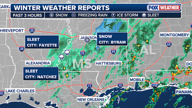
Snow and sleet have been reported this morning across Mississippi and Louisiana.
This morning, winter weather reports have been confirmed as far south as Mississippi and Louisiana, with sleet reported in Fayette and Natchez and snow flurries spotted in Byram.
While the accumulation remains minimal, the arrival of frozen precipitation in these areas highlights the sheer power of the freezer door being left open by the recent Polar Vortex collapse.
This sudden plunge into winter is creating a dangerous flash freeze scenario on the roads, too. As temperatures drop below freezing behind the cold front, any lingering moisture from yesterday’s torrential rains could turn into ice, making the Monday commute hazardous for drivers from Alexandria, Louisiana, through Jackson, Mississippi.
Yesterday was officially a day for the record books. According to the FOX Forecast Center, Sunday was the most active 24-hour period for severe weather in the United States in nearly nine months.
With 384 storm reports currently logged—a number that is still climbing as reports are completed—yesterday surpassed every major event since the widespread outbreak of June 25, 2025, which saw 389 reports.
If just six more reports are added to yesterday's tally, March 15 will officially become the most active severe weather day since June 19, 2025, which holds the current benchmark of 453 reports.
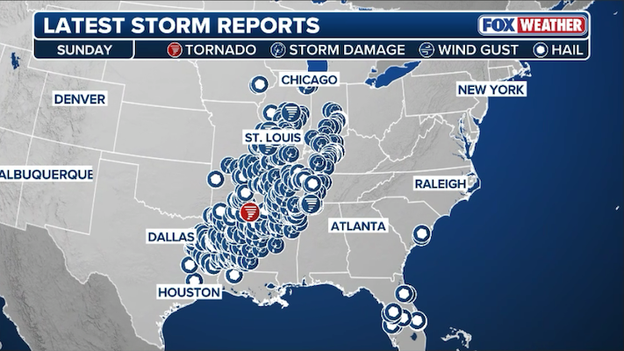
Severe weather reports spanning across America on Sunday.
Dangerous blizzard conditions are impacting millions in the Midwest with strong winds, feet of snow, and rough waves along Lake Superior.
FOX Weather Correspondent Robert Ray is LIVE in Marquette, Michigan with the latest as he continues his coverage from the bullseye of this storm.
A new Tornado Watch has been issued for parts of Georgia, Florida, and South Carolina until 2 p.m. ET.
The severe weather threat is increasing across the Deep South as the Storm Prediction Center has issued a Tornado Watch for portions of Georgia, Florida, and South Carolina until 2 p.m. ET.
This watch covers a region currently being hammered by a fast-moving squall line, with atmospheric conditions supporting both damaging wind gusts and the potential for a few tornadoes.
Residents in cities from Tallahassee to Savannah to Columbia should remain on high alert through the early afternoon, as these fast-moving storms are capable of producing quick spin-ups with very little lead time.
As the morning progresses, the scale of the massive March storm's impact on air travel has reached staggering new heights. According to FlightAware, as of 8:00 a.m. ET, a total of 17,766 U.S. flights have been disrupted since Sunday, creating a massive backlog that is expected to haunt travelers through Tuesday.
FlightAware MiseryMap showing flight disruptions at major airport hubs across America.
This cumulative total includes 5,331 outright cancellations and 12,435 delays, as airlines struggle to navigate a volatile combination of historic blizzard conditions in the Midwest and a dangerous line of severe thunderstorms tearing through the Southeast and Mid-Atlantic.
With major hubs like Atlanta, Charlotte, and Houston already facing early morning ground stops, these numbers are climbing by the minute, turning what was supposed to be a peak spring break travel week into a massive test of patience for millions of passengers.
FOX Weather meteorologists Britta Merwin and Craig Herrera break down today's rare severe weather threat along the East Coast.
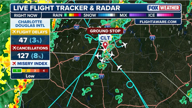
A ground stop is in effect for Charlotte Douglas International Airport until 8:30 a.m. ET.
Thunderstorms have triggered a morning ground stop at Charlotte Douglas International Airport (CLT), bringing a halt to inbound traffic from across the Southeast.
The FAA issued the freeze as storms move through the Carolinas, with the current stop in effect until 8:30 a.m. ET.
With over 15,000 disruptions already clogging the national aviation system, travelers at the American Airlines hub should prepare for significant gate holds and a ripple effect of delays well into the afternoon.
Travelers at George Bush Intercontinental Airport (IAH) are facing fresh disruptions as the Federal Aviation Administration has issued a new ground stop for flights heading into the Houston hub.

The FAA has ordered a ground stop for Houston's George Bush Intercontinental Airport until 9:00 a.m. ET.
High winds trailing a powerful cold front have made operations unsafe, keeping the freeze in effect until 9:00 a.m. ET.
With north winds currently gusting up to 35 mph across the region, IAH joins a growing list of major airports battling extreme weather, adding further pressure to a spring break travel window already strained by more than 5,000 national cancellations.
If it feels like the weather is having a collective identity crisis, you aren't imagining it. Our massive March storm is the byproduct of a massive atmospheric collision fueled by two extreme opposites.
Just last week, we witnessed a full collapse of the Polar Vortex. Normally, this swirling pool of frigid air is penned up at the North Pole by a strong, circular jet stream.
However, a major stratospheric warming event caused the vortex to split and buckle, effectively opening the freezer door and spilling a core of Arctic air deep into the American Heartland.
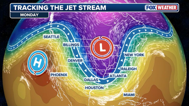
A huge dip in the jet stream (trough) has allowed cold air to dive toward the Gulf Coast while intense heat bakes the West.
This disruption threw the jet stream into absolute chaos. Instead of a steady West-to-East flow, the jet stream has become highly wavy and fragmented, acting like a high-speed conveyor belt that is currently dragging that Arctic chill directly into a clash with record-breaking warmth.
As the jet stream dipped south, it tapped into a marine heat wave in the Gulf of America, where water temperatures are currently sitting as much as 10°F above normal.
This record-warm moisture is the high-octane fuel for the severe thunderstorms and tornadoes we're seeing in the South, while the cold side of the same jet stream is manufacturing the historic blizzard conditions in the North.

When you combine a broken Polar Vortex with a fuel-injected Gulf, you get the volatile, split-screen extreme weather currently stretching from Texas to the Great Lakes.
A life-threatening blizzard is slamming the Midwest and Great Lakes with heavy snow, power outages and dangerous wind gusts.
FOX Weather Meteorologist Jane Minar is LIVE in Traverse City, Michigan this morning with the latest
FOX Weather Correspondent Robert Ray is LIVE in Marquette, Michigan today as howling wind gusts and heavy snow slam the state.
For the first time in over 15 years, a Blizzard Warning is in effect for Milwaukee and much of Southeast Wisconsin.
The National Weather Service issued the rare alert as the storm intensifies, bringing a combination of blinding snow and powerful wind gusts of up to 45 mph.
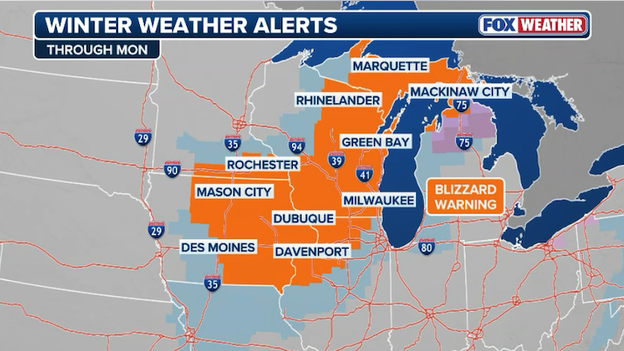
Blizzard Warnings are in effect for more than 9 million Americans this morning.
The last time the Brew City faced a Blizzard Warning of this magnitude was during the historic Groundhog Day Blizzard of 2011, making this a generational weather event for the region.
The timing couldn't be worse for the Monday morning commute. Conditions have deteriorated rapidly, with visibility dropping to one-quarter mile or less as the storm transitions from a wet, heavy snow to a drier, wind-whipped variety.
Milwaukee County Executive David Crowley has declared a Snow Emergency, closing all non-essential county facilities, including the courthouse and the Milwaukee County Zoo.
Residents are being urged to stay off the roads entirely, as plows struggle to keep up with the blinding whiteout conditions that are expected to persist until late afternoon today.
Travel across the heart of Iowa remains a dangerous impossibility this morning as Interstate 80 and Interstate 35 remain shuttered by the Iowa Department of Transportation.
Despite the snow tapering off in some areas, wind gusts of 50–60 mph are continuing to whip existing snow into ground blizzards, creating total whiteout conditions that have rendered the roads impassable.
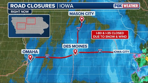
Interstates 35 and 80 remain closed across Iowa as intense winds create whiteout conditions.
As of 5:30 a.m. CT, I-80 is closed in both directions for a massive stretch from Council Bluffs (mile marker 8) all the way to Iowa City (mile marker 240). Similarly, I-35 remains closed from Ames north to the Minnesota state line.
The Iowa State Patrol reports that hundreds of drivers were stranded overnight, with emergency crews working in near-zero visibility to clear multi-vehicle pileups.
Authorities are maintaining a "Travel Not Advised" alert for the majority of the state, warning that even as plows begin to make progress, the combination of sub-zero wind chills and drifting snow makes any time spent on the road potentially life-threatening.
A rare and dangerous weather setup is unfolding today as a powerful storm system pivots toward the Atlantic Seaboard.
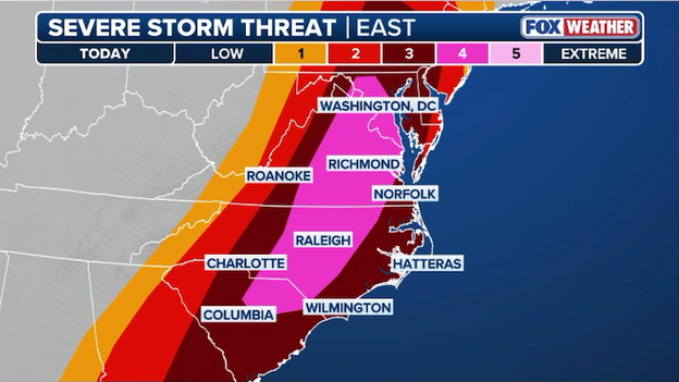
A rare Level 4 of 5 severe storm threat zone has been issued for portions of Maryland, Virginia, North Carolina, and South Carolina.
FOX Weather meteorologists are tracking a surge of warm, humid air—with dew points reaching the 60s—climbing as far north as Pennsylvania. This moisture is acting like high-octane fuel for an incoming line of storms.
Because the winds high above the ground are moving at incredible speeds (over 60 mph), any thunderstorm that forms today will be moving extremely fast.
This creates a double threat: first, a risk of individual, rotating storms called supercells that could produce strong, long-track tornadoes; and second, a sweeping line of storms capable of causing widespread wind damage as they pull those high-altitude winds down to the ground.
The window of greatest concern opens early this afternoon and lasts through the evening commute.
The FOX Forecast Center is particularly worried about the "spin" in the atmosphere, which is currently at extreme levels. If we see any breaks in the clouds that allow the sun to heat the ground, the risk for intense tornadoes will increase significantly.
Whether it’s a lone rotating storm or a solid wall of wind, the entire region from North Carolina up through the Mid-Atlantic needs to be on high alert.
A ground stop has been ordered by the FAA for flights heading to Atlanta's Hartsfield-Jackson International Airport.
Hartsfield-Jackson Atlanta International Airport has been brought to a standstill this morning as a Tornado Warning and intense severe storms triggered a mandatory ground stop for all inbound flights from airports in the Southeast.
The freeze, which is currently in effect until 7:30 a.m. ET, is causing a massive ripple effect across the Southeast, with the FAA halting traffic from major regional centers as a squall line moves directly over America's busiest airport.
For spring breakers and commuters alike, this adds another layer of chaos to a morning already plagued by over 5,000 national cancellations, as lightning and 60-mph wind gusts make ground operations at the Atlanta hub impossible.
For thousands of students and families, the dream of a relaxing spring break has turned into a terminal-floor reality.
A massive weather system is currently gutting flight schedules across the country, with more than 5,000 cancellations and 10,800 delays reported so far.

FlightAware data shows hundreds of flights have been canceled today at major hubs across the nation.
From college juniors stranded in Denver to families stuck in Chicago, the historic March storm is hitting during one of the year’s highest-demand travel windows, leaving almost zero empty seats for those trying to rebook.
The disruption is a perfect storm of bad timing. While the Midwest struggles to dig out from record-breaking snow, the East Coast is bracing for a line of violent thunderstorms that will trigger ground stops at major vacation gateways like Atlanta, Charlotte, and D.C. later today.
Adding to the stress, travelers are reporting two-hour security lines and "ghost town" terminals where wait times for airline customer service have surged past the five-hour mark.
If you're heading to the airport today, bring a charger and a lot of patience—this spring break is officially off to a rocky start.
In response to today's predicted rare and dangerous severe weather outbreak, DC Public Schools (DCPS) has announced that all schools will close two hours early today.
The decision comes as the Storm Prediction Center places the District under a Level 4 of 5 risk for severe thunderstorms—a classification the region hasn't seen in years.
By dismissing early, DCPS aims to get students and staff home before the most volatile window of weather begins.
FOX Weather meteorologists expect a powerful squall line to tear through the D.C. metro area between 3:00 p.m. and 7:00 p.m., bringing the threat of destructive 80-mph wind gusts, large hail, and tornadoes.
All after-school programs, athletic events, and evening activities have also been canceled to ensure families can remain sheltered while the front passes.
Power outages have skyrocketed as the storm system sweeps eastward, with over 546,000 U.S. customers currently without electricity this Monday morning.
One customer = one address, so the number of Americans without power could be dramatically higher.

Latest power outage tracker showing significant outages across the eastern half of the United States. (PowerOutage.com)
Michigan is bearing the brunt of the infrastructure damage with more than 114,000 reported outages, largely due to the heavy, wet snow and high winds from the historic blizzard.
The outage map also highlights significant clusters across Ohio (61.5k), Texas (36.2k), and the Deep South, where severe thunderstorms and overnight tornadoes have downed lines across Mississippi and Georgia.
Utility crews face a grueling recovery effort as the volatile weather continues to move through the Mid-Atlantic and Northeast, threatening to push these numbers even higher as the day progresses.
To catch up on the initial wave of this historic March storm, you can revisit our coverage from Sunday.
We tracked the first confirmed tornadoes hitting Arkansas, the dramatic 137-year snow record set in Green Bay, and the emergency closure of I-80 and I-35 as blizzard conditions first took hold of the Heartland.
Click here to jump back to see yesterday's minute-by-minute updates.
You’ve reached the beginning of this live coverage.