Live updates: Blizzard 'bomb' blasts the Midwest, significant severe weather outbreak slams millions
Live updates: Blizzard 'bomb' blasts the Midwest, significant severe weather outbreak slams millions
Download the AppMonday, March 16 - LIVE coverage has moved
View postCoverage for this event has ended.
While we tracked record-breaking snow in the Midwest yesterday, the focus is shifting to a rare Level 4 severe weather outbreak for the East Coast and ongoing blizzard conditions in the Great Lakes.
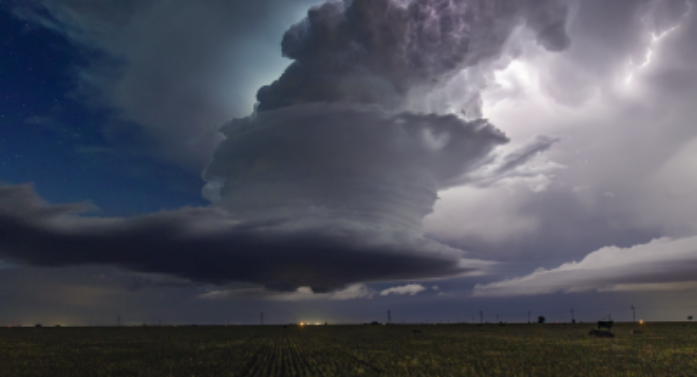
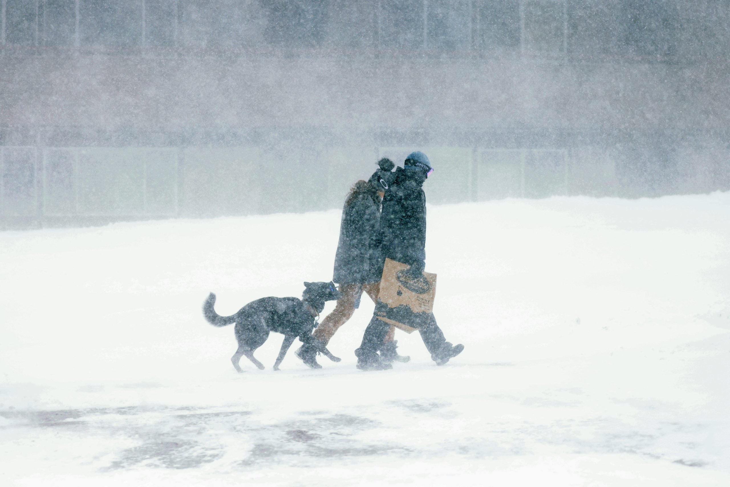
FOX Weather Correspondent Robert Ray captured this video of howling wind gusts and blinding snow that slammed Marquette, Michigan Sunday — he will have new report with the latest conditions later this morning.
Marquette saw 14.6 inches of snow Sunday and combined with expected accumulations Monday, this could set a new record for the city and other parts of the Upper Peninsula.
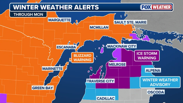
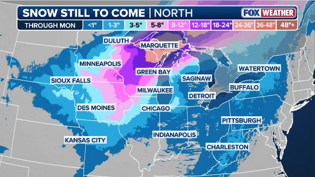
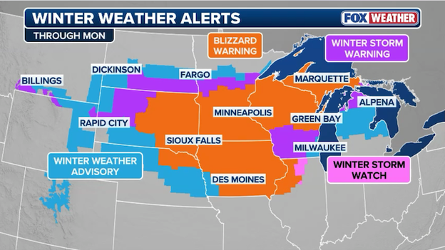
Blizzard Warnings are in effect Monday across southern Minnesota, Iowa and northwestern Illinois, as well as most of Wisconsin, including Milwaukee and Green Bay, and parts of northern Michigan and the Upper Peninsula.
More than 2 feet of snow has fallen in Wisconsin and Michigan since Sunday, with potentially historic accumulations expected in the Upper Peninsula.
Life-threatening travel conditions are expected across the region through Monday night.
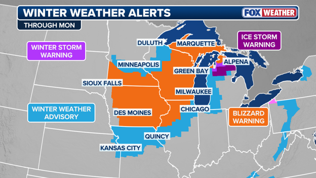
Winter Weather Alerts
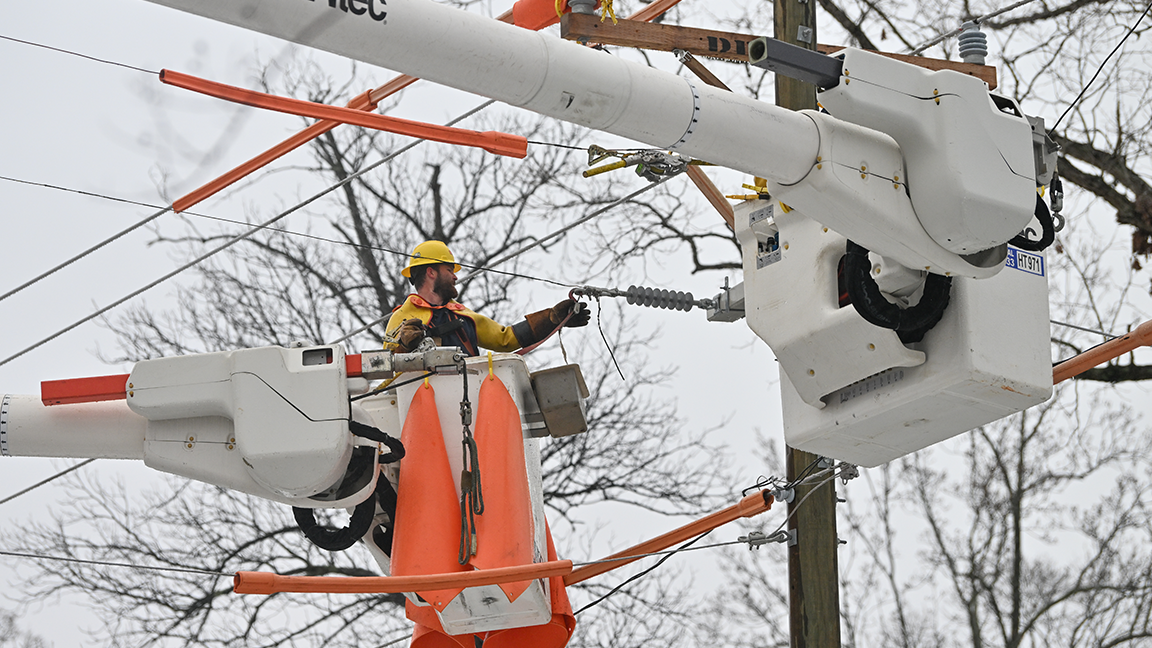
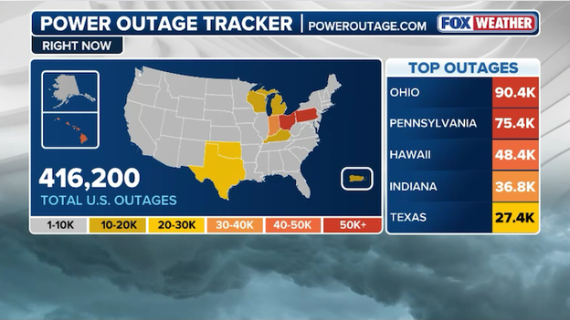
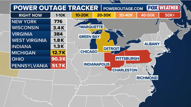
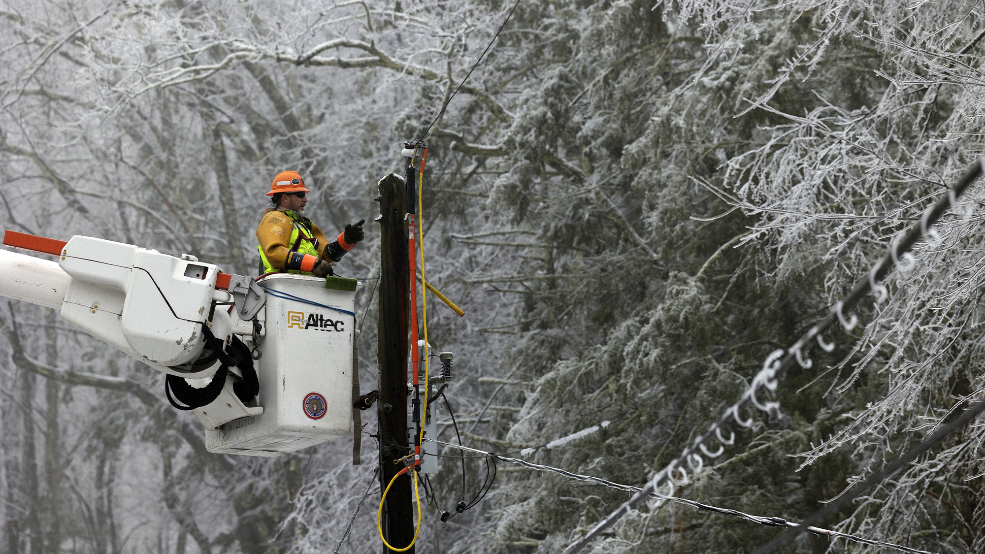
Nearly 550,000 customers are without power early Monday across the Midwest, Ohio and Tennessee valleys and the Deep South.
More than 114,000 households are in the dark in Michigan, where more than 2 feet of snow has fallen in some locations.
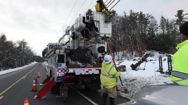
Storms knock out power to hundreds of thousands
A life-threatening blizzard is slamming the Midwest and Great Lakes with heavy snow, power outages and dangerous wind gusts. FOX Weather Meteorologist Jane Minar is live in Traverse City, Michigan with the latest.
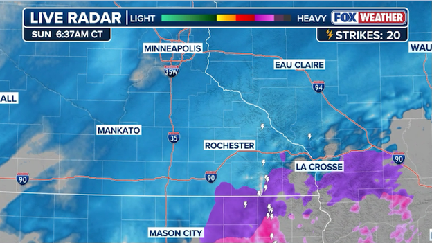
Heavy snow continues to blanket parts of Southern Minnesota, with locations across the state under Blizzard and Winter Storm Warnings late Sunday.
Powerful wind gusts have been observed throughout the region, which will create blowing snow, reduce visibility, and strengthen blizzard conditions through the night.
Wind gusts of up to 45 mph have been recorded in Mankato, Minnesota, and the area has received nearly 10 inches of snow, with some areas seeing around 12 inches.
Conditions are expected to improve for Monday morning commuters, according to the National Weather Service.
The National Weather Service office in Nashville, Tennessee, has issued nearly a dozen Severe Thunderstorm Warnings within the last hour.
This comes as a line of storms will move across Middle Tennessee overnight. According to NWS officials, damaging wind gusts of over 75 mph are possible.
There is a medium tornado threat across the region.
Popular locations such as Nashville and Chattanooga, Tennessee, are under a Tornado Watch throughout the evening.
A barn is demolished during a severe weather event as gusty winds rip the structure to the ground. Luckily, all the animals are safe and accounted for.

The National Weather Service issued a High Wind Warning for parts of Missouri until 4 a.m. CDT.
Damaging winds are blowing down trees and power lines, causing power outages in parts of the state.
Governor Wes Moore declares a State of Preparedness ahead of severe weather expected to impact Maryland.
Widespread severe storms and tornadoes are forecast to impact the state on Monday.
The Storm Prediction Center has issued a dangerous Level 4 out of 5 for the severe weather on Monday.
The storms could produce damaging winds up to 70 mph and strong tornadoes throughout the region.
Much of the Great Lakes region is being pounded by an intense blizzard, bringing life-threatening conditions.
A plethora of Blizzard Warnings nearly covers the state, with parts of northwest Wisconsin under a Winter Weather Advisory.
Experts at the National Weather Service office in Green Bay say conditions will continue to deteriorate. Many roads are already impassable, and travel is not advised for people in northern Wisconsin.
Locations such as Crivitz, Wisconsin, have already received more than 2 feet of snow.
The atmosphere is rapidly destabilizing across the South, and the Storm Prediction Center has indicated that a Tornado Watch has be issued for parts of Alabama, Georgia and Tennessee until 3 AM CDT.
The National Weather Service warns that, in addition to a potential tornado threat, storms could produce damaging wind gusts up to 70 mph and hail up to quarter size.
Stay with FOX Weather as this severe weather situation continues to unfold across the South.
Dangerous winter weather has brought travel to a standstill across the heart of Iowa, forcing the Iowa Department of Transportation (DOT) to shut down major stretches of Interstate 80 and Interstate 35.
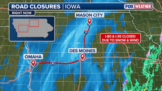
Major Iowa interstates are shut down right now due to blizzard conditions.
As of Sunday evening, I-80 is closed in both directions from West Des Moines all the way to Council Bluffs due to a series of multi-vehicle crashes and impassable drifts.
Meanwhile, I-35 is shut down from Ames north to the Minnesota state line, where high winds and heavy snow have created total whiteout conditions.
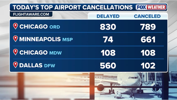
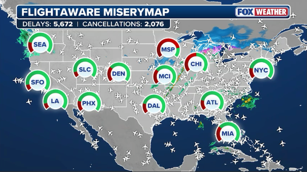
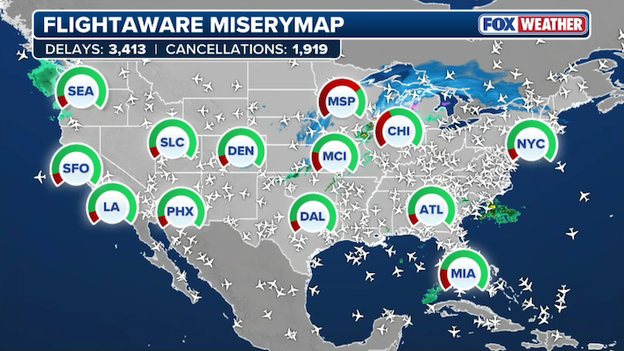
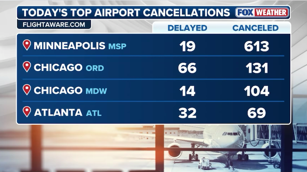
A monster storm slicing across the United States has officially triggered a massive wave of delays and cancellations, with nearly 12,000 flights disrupted as of Sunday evening.
According to the latest real-time data from FlightAware, the total has hit a staggering 11,717 disruptions within, into, or out of the country.
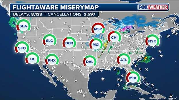
FlightAware MiseryMap showing widespread flight disruptions across America.
This includes 3,319 full cancellations and 8,398 delays through Monday so far, as airlines struggle to maintain schedules against a backdrop of blizzard conditions in the Midwest and violent thunderstorms in the Heartland.
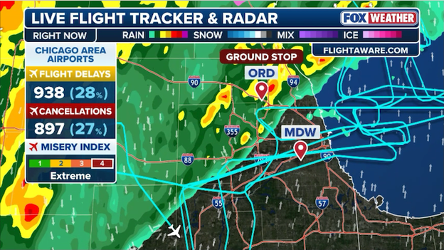
The travel misery is particularly acute at major hubs like Minneapolis-St. Paul (MSP), where runway capacity has been slashed by record-breaking snow, and Chicago O'Hare (ORD), which has faced multiple ground stops due to high winds and lightning.
As storms move toward the Atlantic, the ripple effect is paralyzing the I-95 corridor, forcing carriers like Delta, American, and Southwest to issue broad travel waivers.
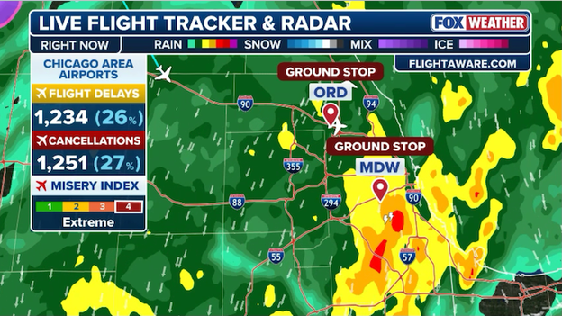
Delays and cancellations are increasing at Chicago airports due to ground stops.
Thunderstorms have forced the FAA to issue ground stops at both O’Hare and Midway international airports this evening, bringing air traffic in and out of Chicago to a temporary standstill.
O'Hare's latest ground stop is in effect until 9 p.m. ET and Midway's lifts at 8 p.m. ET.
That means flights destined to these airports are being held at their departure point until the ground stop is lifted.
A staggering 26.0 inches of snow has been recorded in Spalding, Michigan, as the historic March blizzard slams the Upper Peninsula.
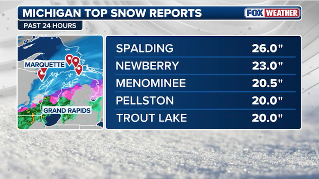
Latest top snow totals from Michigan.
This massive total highlights the intensity of the storm, which is currently delivering snow rates of up to 3 inches per hour alongside 60-mph wind gusts.
With travel rendered impossible across Menominee County and much of the central U.P., Spalding’s report stands as one of the highest in the state so far, with officials warning that drifting snow could push these piles even higher by Monday morning.
Residents in Green Bay will be digging out from a truly historic winter event once the blizzard ends.
As of 4:00 p.m. CT, the National Weather Service has recorded a staggering 14.8 inches of snow, officially marking this as the 3rd snowiest day in the city's history.
This isn't just a big storm; it’s a record-breaker that spans generations. Today's total stands as the snowiest day in Green Bay in 137 years, trailing only the legendary blizzards of the late 1880s.
To put that in perspective, the last time the city saw a single-day accumulation this intense, Benjamin Harrison was being inaugurated as President.
The heavy, wind-driven snow has brought the region to a near-standstill, causing widespread power outages and making travel across Northeast Wisconsin virtually impossible.
Today's 14.8-inch total now sits firmly among the all-time greats:
- 24.0 inches – March 1, 1888
- 18.0 inches – January 1889
- 14.8 inches – March 15, 2026
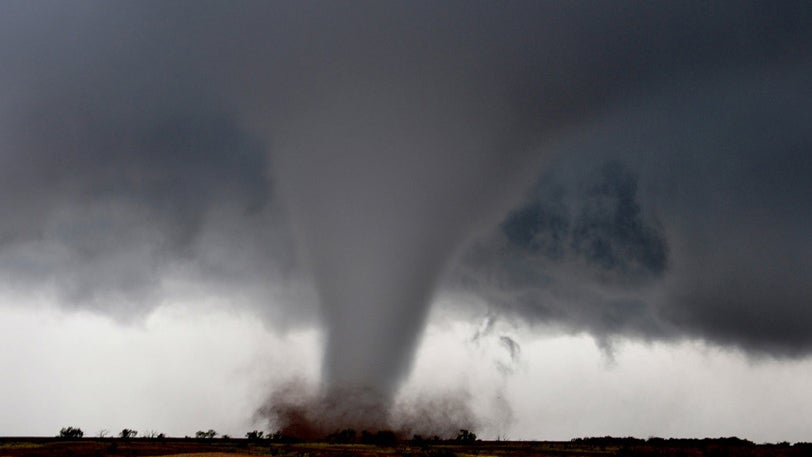
Tornadoes at any time of day can cause mass amounts of destruction, but tornadoes in the dark are far more likely to turn deadly.
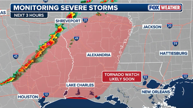
A Tornado Watch will be issued across East Texas and Louisiana shortly.
The atmosphere is rapidly destabilizing across the South, and the Storm Prediction Center has indicated that a Tornado Watch will be issued shortly for East Texas and Louisiana.
Forecasters emphasize that while straight-line winds are the primary hazard, the intense wind shear could produce quick tornadoes with very little lead time.
With night falling across the region, the danger is increasing as nighttime tornadoes are far more likely to turn deadly.
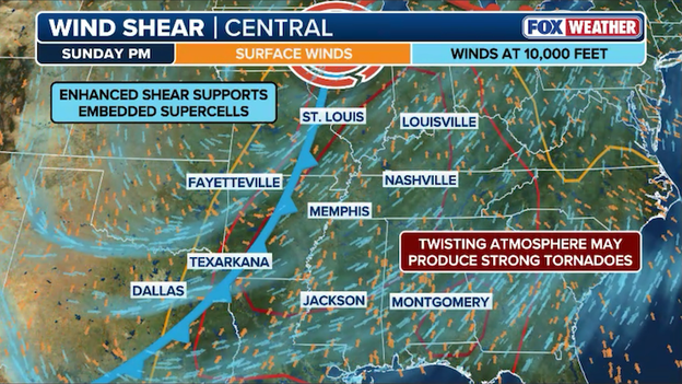
Right now, the FOX Forecast Center says the atmospheric setup is becoming more favorable for supercell development across the South this evening.
As a cold front interacts with a strong low-level jet, wind shear is rapidly increasing, providing the spin necessary for storms to become organized and rotate.
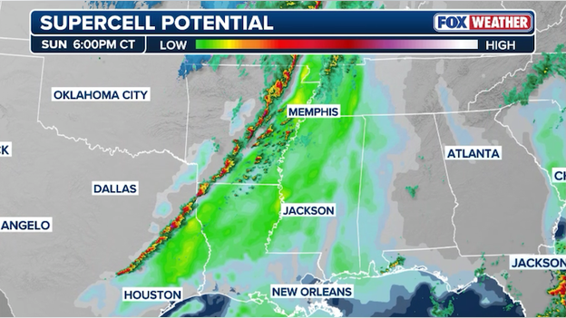
Analysis shows the threat for supercell thunderstorms is increasing across the South ahead of a squall line.
While much of the activity today has been a linear squall line threat, FOX Weather meteorologists are seeing the most dangerous potential in areas where individual cells can break away or form ahead of the main line.
These discrete supercells are more likely to produce large, long-track tornadoes because they don't have to compete with neighboring storms for energy.
The combination of high instability and deepening surface low pressure means that any storm that stays isolated for more than 30 minutes has a high probability of becoming a significant tornadic producer.
As severe storms continue to hammer the Heartland and beyond, power outages across the United States have surged to over 424,000, with the numbers climbing rapidly as the weather intensifies.
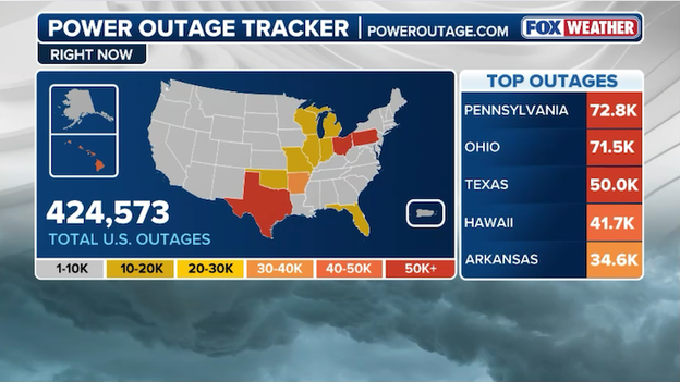
Latest power outage tracker showing significant outages across America. (PowerOutage.com)
Pennsylvania and Ohio are currently bearing the brunt of the problems, reporting a combined total of over 144,000 customers in the dark after high winds lashed the region on Friday.
From the severe storms in Arkansas to the intense wind-driven snow in the Midwest, the monster storm system is proving to be a major test for the grid, with significant outages also stretching as far as Texas and Hawaii.
Utility crews are on high alert, but with the front still moving through, restoration efforts may be delayed until the most dangerous conditions subside.
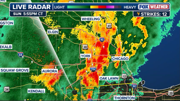
Radar showing powerful thunderstorms roaring through the Chicago metro area on Sunday evening.
Chicago is witnessing a dramatic atmospheric shift tonight as a line of powerful thunderstorms roars through the metro area, bringing frequent lightning and gusts up to 50 mph.
These storms mark the final surge of warm air before a sharp cold front arrives, which is expected to plummet temperatures by 30 degrees in just a few hours.
As the rain transitions to wind-whipped snow overnight, the National Weather Service warns that Monday morning commuters will face a treacherous mix of slushy roads and significantly reduced visibility.
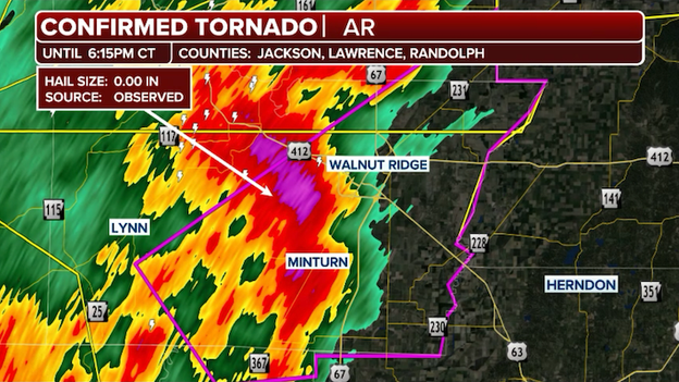
A tornado has been spotted in Minturn, Arkansas.
A life-threatening situation is currently unfolding in Northeast Arkansas. At 5:46 p.m. CT, weather spotters confirmed a tornado in Minturn, or near Hoxie.
The storm is racing northeast at a dangerous 55 mph, packing the potential for significant structural damage.
The National Weather Service has extended the Tornado Warning until 6:15 p.m. CT for southeastern Randolph, northeastern Jackson, and southern Lawrence counties.
This is a confirmed hazard, meaning a damaging tornado is actively occurring. Residents in the path—including those in Hoxie, Walnut Ridge, and Alicia—must take shelter immediately.
With a Level 4 of 5 for severe weather issued for parts of the East Coast, local officials are taking no chances with Monday’s commute.
Major school districts across North Carolina, Virginia, and South Carolina—including Wake County, Durham, and Guilford County Schools—have already announced they will be closed on Monday.
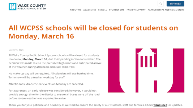
Wake County, North Carolina Public Schools website announcing Monday's canceled classes.
The primary concern is the timing of a powerful cold front that is expected to trigger widespread destructive wind gusts of 65–75 mph and potential tornadoes during the afternoon hours, making bus travel and outdoor activities unsafe.
In addition to school shutterings, several local businesses and community organizations have announced early closures or full-day cancellations to ensure employees are off the roads before the most volatile storms arrive.
A massive wave of extreme weather is creating travel chaos for spring breakers.
According to the latest data from FlightAware, more than 10,000 flights within, into, or out of the United States have been disrupted as extreme weather hammers nearly every corner of the country.
As of this evening, the total includes 7,226 delays and 2,902 cancellations through Monday.
Latest flight delays and cancellations for Sunday. (FlightAware)
The primary drivers of this travel chaos are the blizzard conditions currently paralyzing the Upper Midwest—where Minneapolis-St. Paul (MSP) has seen over 70% of its schedule wiped out—and a squall line triggering ground stops at major hubs like Chicago O'Hare (ORD).
With severe thunderstorms moving into the East Coast and high winds continuing to lash the Northeast, airlines are warning that these numbers will continue to climb as the ripple effect of displaced crews and aircraft carries into the work week.

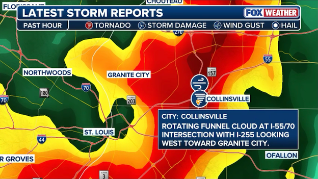
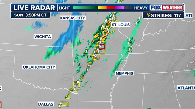
Storm report east of St. Louis, Missouri.
A funnel cloud has been spotted just east of St. Louis as a line of violent thunderstorms pushes across the Mississippi River Valley into Illinois.
This sighting comes following a Tornado Warning for the metro area, where intense radar rotation and 70-mph wind gusts threatened communities on both sides of the river.
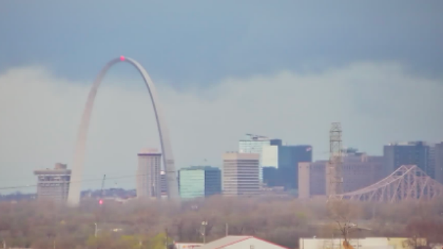
Camera showing dark clouds near The Gateway Arch in St. Louis, Missouri on Sunday evening.
A line of severe thunderstorms is slamming the St. Louis metropolitan area this evening, bringing the threat of destructive winds and isolated tornadoes.
The FOX Forecast Center is currently monitoring for any damage reports as the storm clears the area in the next hour.
A powerful cold front moving through Central Oklahoma has brought down power poles and lines, forcing a closure of Interstate 35 in Norman.
Oklahoma Transportation camera showing I-35 at a standstill due to a closure near Norman.
The Oklahoma Department of Transportation reports southbound lanes are closed as crews work to clear the lines.
With wind gusts reaching 60 mph today, thousands of residents are without power as crews struggle to repair the infrastructure in high-wind conditions.
Drivers are being diverted to local side streets, but with blowing dust and continued gusts, traffic through the Norman corridor remains at a standstill.
Camera showing driving conditions along HWY 40 near St. Louis, Missouri.
The FOX Forecast Center is tracking an intense storm tracking right into the St. Louis metro area right now.
A Tornado Warning has been issued by the National Weather Service as the storm shows signs of rotation and could produce a tornado at any moment.

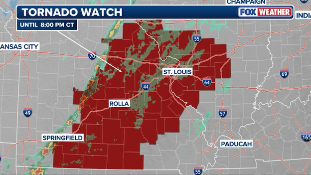
A Tornado Warning has been issued for St. Louis, Missouri.
A Tornado Warning has been issued for the St. Louis metropolitan area as the storm takes a violent turn across eastern Missouri.
Forecasters are tracking a particularly dangerous cell within a fast-moving squall line that has already shown signs of rotation on radar.
This warning comes as the city remains under a broader Tornado Watch until 8:00 p.m. CT, with the National Weather Service reporting that these storms are capable of producing not only tornadoes but also destructive straight-line winds exceeding 70 mph.
A ground stop has been issued for Chicago O'Hare International Airport until 6:45 p.m. ET.
Air travel at one of the nation’s busiest hubs has come to a temporary standstill this evening.
The Federal Aviation Administration has issued a ground stop for Chicago O'Hare International (ORD) effective until 6:45 p.m. ET (5:45 p.m. CT) as severe thunderstorms move through northern Illinois.
This stop specifically impacts inbound flights from across America, which are being held at their departure airports to manage the congestion caused by the storms.
FlightAware reports that over 9,000 U.S. flights have been disrupted as of Sunday evening, with extreme weather conditions across the country forcing 6,561 delays and 2,702 cancellations through Monday.
Latest flight delay and cancellation statistics from FlightAware.
This widespread gridlock stems from a combination of blizzard conditions in the Midwest, severe thunderstorms in the South, and high winds in the Northeast that have challenged even the busiest airline hubs.
With nearly 30% of these disruptions being total cancellations, travelers are encouraged to monitor their flight status closely as the storm system continues its eastward push.
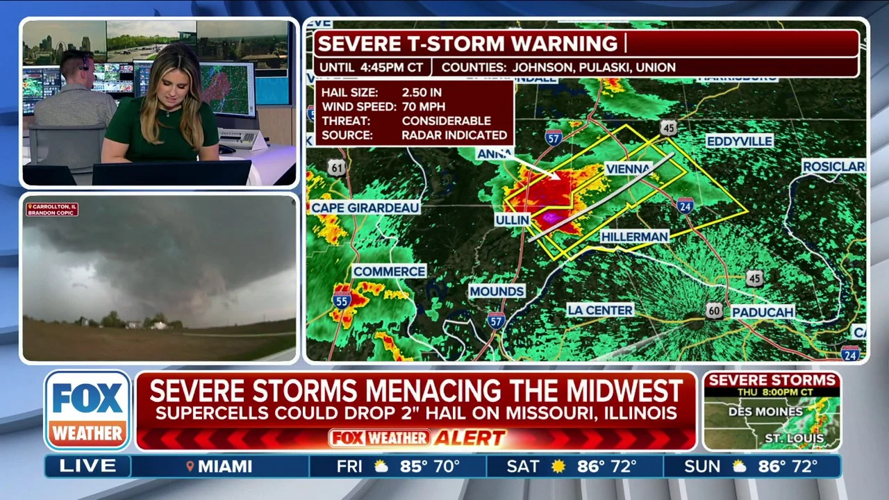
A Severe Thunderstorm Warning has been issued for St. Louis, Missouri until 5:15 p.m. CT.
A Severe Thunderstorm Warning has been issued for the St. Louis metropolitan area until 5:15 p.m. CT as a volatile line of storms hammers the region with destructive potential.
This fast-moving system is currently packing wind gusts up to 60 mph, which are strong enough to down power lines and topple trees onto homes.
While the primary threat is straight-line wind damage, the National Weather Service warns that the intense energy in this line could also produce isolated, quick-spinning tornadoes with little to no lead time.
Residents are urged to move to an interior room on the lowest floor of their building immediately and stay away from windows until the warning expires.
Radar showing the Snow Squall Warning near Kansas City and Tornado Warnings in the eastern and southern part of the state.
Missouri is the definition of weather whiplash today as it sits on the knife-edge of two extreme air masses.
In the west, the National Weather Service in Kansas City has issued Snow Squall Warnings as a powerful cold front surges through, bringing intense bursts of heavy snow and 60-mph wind gusts that can drop visibility to zero in seconds.
Meanwhile, the eastern side of the state is under a Tornado Watch, with active warnings recently firing up for the St. Louis metro area as a line of violent thunderstorms taps into the warm, unstable air ahead of that same front.
The blizzard continues to relentlessly batter the Great Lakes, with residents in Milakokia Lake, Michigan, facing dangerous whiteout conditions as wind gusts surge.
This storm is currently generating sustained northeast winds of 30–40 mph, with gusts as high as 60 mph whipping the heavy, wind-driven snow into massive drifts.
Travel in the eastern Upper Peninsula has become effectively impossible, as visibility remains near zero and snowfall rates occasionally peak at 1 to 3 inches per hour.
The sheer power of the blizzard is on full display along the Lake Michigan shoreline, where giant waves of ice and slush are violently crashing against the frozen coast.
Fueled by 60-mph gusts from the intensifying storm, these massive surges are creating a dangerous spectacle as freezing spray and chunks of ice are tossed onto piers and coastal roads.
Authorities are warning residents to stay far back from the water's edge, as the combination of unstable ice shelves and life-threatening whiteout conditions makes the shoreline incredibly treacherous tonight.
Latest top snow totals from Michigan.
Menominee has recorded a staggering 20.5 inches of snow as the blizzard continues to hammer the Upper Peninsula.
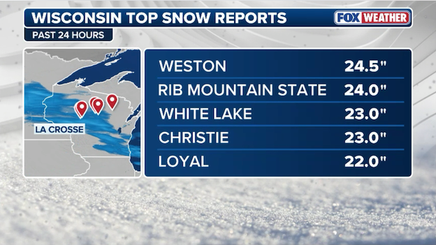
Weston, Wisconsin, has officially joined the "two-foot club," recording a massive 24.5 inches of snow during this historic March blizzard.
Latest top snow totals from Wisconsin.
This total slightly edges out the nearby report from Rib Mountain, cementing Central Wisconsin as the epicenter of the storm's most intense snow for now. The Upper Peninsula of Michigan is expected to bear the brunt of the snow with up to four feet expected through Monday.
With the snow still falling and wind gusts creating massive drifts, travel in the Weston and Wausau areas remains extremely hazardous.
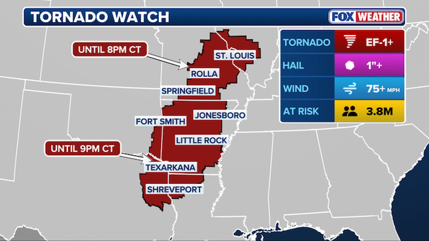
A massive severe weather outbreak has triggered Tornado Watches across 10 states as a violent line of storms charges toward the East Coast.
The watch area currently spans a vast portion of the country's midsection and Southeast, including parts of Missouri, Illinois, Indiana, Kentucky, Tennessee, Arkansas, Mississippi, Alabama, Texas, and Oklahoma.
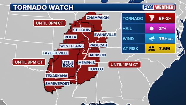
10 states across America's Heartland and the South are now under a Tornado Watch.
Meteorologists are tracking a vicious squall line that is capable of producing not only quick-spinning tornadoes but also destructive straight-line winds exceeding 70–80 mph.
As this line pushes east into the evening, the risk of nighttime tornadoes increases, making it vital for residents in the watch zones to have multiple ways to receive emergency alerts while they sleep.
While much of the country battles snow and dust, South Florida is currently drowning under torrential downpours.
The National Weather Service has issued a Flash Flood Warning for Miami-Dade County, as slow-moving clusters of thunderstorms dump rain at staggering rates of 1 to 2 inches per hour.
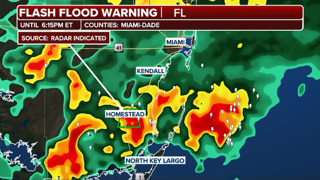
A Flash Flood Warning has been issued for parts of Miami-Dade County in South Florida.
Areas of the Florida Everglades in western Miami-Dade have already reported over 3 inches of rain, and that moisture is now shifting into the dense urban corridors.
With the ground already saturated from a wet weekend, significant street flooding is occurring in low-lying areas, particularly from Miami down to Homestead.
Residents are urged to avoid driving through flooded roadways—remember, "Turn Around, Don't Drown"—as it only takes a few inches of moving water to sweep a vehicle off the road.
A vicious squall line is currently erupting across the Heartland, serving as the violent leading edge of the same system that is burying the North in snow.
This line of intense thunderstorms is charging through the Mississippi and Ohio Valleys, with forecasters warning of kinks in the line that could trigger quick-spinning tornadoes with little to no warning.
Radar showing the vicious line of severe thunderstorms erupting across the Heartland.
The primary threat from this advancing wall of storms is destructive straight-line winds, with gusts between 60 and 80 mph capable of causing widespread power outages and property damage.
As the sun sets, the danger increases, as these fast-moving storms will be difficult to see and are hitting regions already saturated by earlier rain.
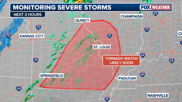
A Tornado Watch has been expanded to cover a significant portion of Illinois as a line of volatile thunderstorms races across the Heartland this evening.
The watch now includes dozens of counties stretching from the St. Louis metropolitan area through southwestern and central Illinois, effective until 10:00 p.m. CT.
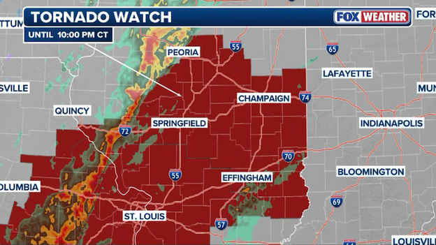
Tornado Watches stretch across multiple states as a powerful squall line roars across the Heartland.
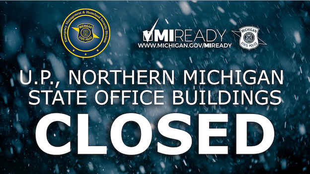
Dangerous winter weather has prompted the State of Michigan to take immediate action to keep employees and the public off the roads.
Due to a combination of heavy snow and freezing rain, all nonessential state facilities in the Upper Peninsula and 13 counties in the northern Lower Peninsula are closed effective immediately.
This closure will remain in effect through 6:00 a.m. on Tuesday.
The specific counties included in this directive are:
- Alpena, Antrim, Benzie, Charlevoix, Cheboygan, Crawford, Emmet, Grand Traverse, Kalkaska, Leelanau, Montmorency, Otsego, and Presque Isle.
@MichEMHS on X
State employees in these regions are instructed to contact their direct supervisors to ensure that essential responsibilities are covered and to finalize any necessary alternate work arrangements.
With travel conditions expected to be life-threatening throughout the blizzard, residents are urged to stay home and avoid any unnecessary travel until the storm system passes and facilities can safely reopen Tuesday morning.
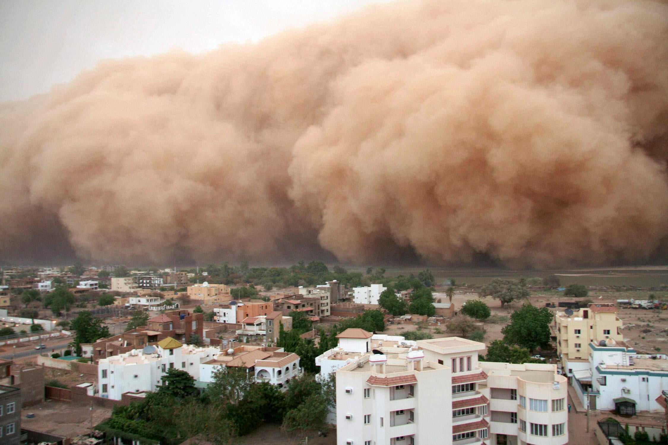
A terrifying scene is unfolding east of Quanah, Texas, where a multi-car wreck has blocked U.S. 287 amid a massive haboob.
High winds and blowing debris have created localized brownout conditions, dropping visibility to near-zero in a matter of seconds.
Video from the scene shows several severely damaged vehicles and tractor-trailers scattered across the roadway, illustrating just how quickly these wind-driven dust walls can turn a routine drive into a life-threatening pileup.
Emergency crews are currently on the scene, but rescue efforts are being hampered by sustained wind gusts of 60 to 70 mph.
Authorities are pleading with drivers to avoid U.S. 287 and other major corridors in the region tonight.
If you are already on the road and encounter a wall of dust, the safest course of action is to pull completely off the pavement, turn off all vehicle lights (including your dome light), and keep your foot off the brake. This prevents other drivers from mistakenly following your lights into the ditch or into the back of your vehicle.
The 'March Mania' storm is living up to its name, significantly stressing the nation’s aviation network this weekend. According to the latest tracking data from FlightAware, more than 8,000 flight disruptions have been recorded across the country through Monday.
This massive figure includes 2,201 canceled flights and 5,884 delays, leaving hundreds of thousands of passengers stranded at hubs from coast to coast.
FlightAware MiseryMap showing the travel headaches mounting across America today.
The chaos is the result of a perfect storm of weather extremes hitting major transit points simultaneously.
Minneapolis-St. Paul (MSP) has been the hardest hit by blizzard conditions, while ground stops due to severe thunderstorms have frozen traffic at Orlando (MCO) and Miami (MIA) during the peak of spring break travel.
Even in regions not seeing snow, wind advisories in the Northeast are causing ripple-effect delays as airlines struggle to reposition aircraft and crews.
With Arctic air set to plunge temperatures tomorrow, travelers are urged to confirm their flight status before heading to the airport, as recovery for the airline industry will likely stretch through the middle of the week.
A ground stop at Orlando International Airport has turned the busiest weekend of the spring break season into a logistical nightmare for thousands of families.
The FAA has halted inbound flights from certain areas of the East Coast until 5:30 p.m. ET as thunderstorms, packing 60-mph gusts and frequent lightning, sweep across Central Florida.
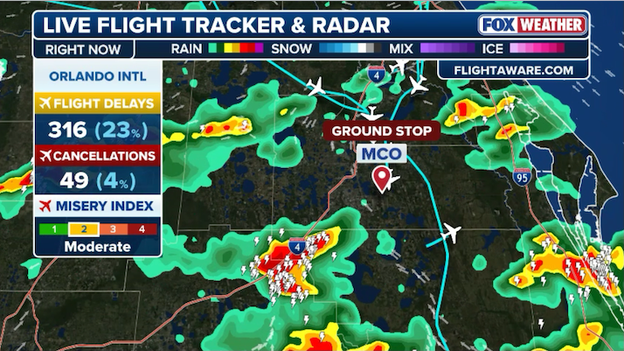
Delays and cancellations are increasing at Orlando International Airport due to a ground stop.
With the airport already reeling from record-breaking crowds—projected to hit over 210,000 travelers today—the sudden halt has left terminal corridors overflowing with families and triggered a wave of gate holds that will likely take days to untangle.
The timing of this is particularly brutal for vacationers trying to head home after visiting the area's world-famous theme parks.
Beyond the immediate delays, this storm system marks the beginning of a major cold front that will send Orlando temperatures into a tailspin, dropping from the 80s into the 40s by early Tuesday.
Travelers are currently facing a double-edged sword of terminal congestion and the threat of mounting cancellations as airlines struggle to reposition planes during the peak of the spring break rush.
Delays are stacking up at Miami International Airport due to a ground stop in effect.
The Federal Aviation Administration has issued a ground stop for Miami International Airport (MIA) this afternoon as a line of strong thunderstorms moves through the South Florida region.
The stop, which applies to all inbound flights from the Southeast U.S. destined for Miami, is currently scheduled to remain in effect until 5:15 p.m. ET.
Miami International is reporting downpours and frequent lightning, making it unsafe for ground crews to operate on the ramp.
Travelers should expect a significant ripple effect through the evening, as this ground stop will likely lead to departure delays and gate congestion once flights are cleared to land.
If you are flying into or out of Miami today, be sure to check your airline's mobile app for the latest tail-specific updates.
A massive wall of dust is currently tearing across Southwest Texas, with its sheer scale captured in striking detail by visible satellite imagery this afternoon.
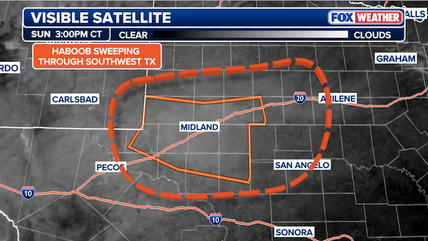
GOES-East captured the haboob tearing across Southwest Texas on Sunday afternoon.
Centered over Midland and Odessa, the haboob is fanning out toward Pecos, San Angelo, and Abilene, fueled by the powerful pressure gradient of the intensifying bomb cyclone to the north.
These brownout conditions have dropped visibility to near-zero along major travel arteries like Interstate 20 and Interstate 10, prompting a Dust Storm Warning from the National Weather Service for drivers to get off the roads.
Residents are urged to secure loose outdoor items and stay indoors until the particulate-heavy air and extreme gusts subside later tonight.
It is official. After three hours of grueling conditions, the FOX Forecast Center has confirmed that Green Bay is in the midst of a verified blizzard.
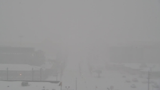
Camera near Lambeau Field in Green Bay, Wisconsin showing whiteout conditions.
While it has been snowing since the morning, the storm officially reached blizzard status this afternoon as visibility dropped below a quarter-mile and wind gusts consistently topped 35 mph for a sustained three-hour window.
The scene at Lambeau Field is a stark reminder of the storm's power. As seen in the image, the iconic stadium is nearly invisible, shrouded in a whiteout caused by the combination of heavy, wind-driven snow and extreme gusts.
This isn't just a typical Wisconsin snowstorm; it is a life-threatening event. With snow rates occasionally hitting 2 inches per hour, total accumulations in Green Bay are expected to land between 12 and 18 inches before the system finally exits on Monday afternoon.
A massive haboob—a wall of wind-driven dust—is currently racing across the Texas Panhandle and South Plains as a powerful cold front surges through the region.
High winds are gusting between 60 and 70 mph, picking up dry topsoil from the parched landscape and dropping visibility to near-zero in cities like Lubbock and Amarillo.
The National Weather Service has issued a Dust Storm Warning where the fiercest conditions are occurring and a Blowing Dust Advisory for much of West Texas, warning that travel along I-27 and I-40 has become extremely hazardous.
This wall of dust is the leading edge of a dramatic weather shift; behind the front, temperatures are plummeting from the 80s into the 50s within minutes.
Beyond the dust, a Fire Weather Warning remains in effect as these intense winds threaten to fan any existing wildfires or spark new ones.
Residents in the path of the dust wall are urged to pull over if they are driving and wait for the "brownout" conditions to pass, as visibility can disappear in an instant.
FOX Weather Correspondent Robert Ray is on the ground in Marquette, Michigan, where a historic blizzard is currently hammering the Upper Peninsula.
Marquette is in the bullseye of this blizzard 'bomb,' with forecasters warning this could be a record-breaking event for the city, with total snow accumulations expected to reach between 2 and 4 feet by Monday night.
With wind gusts along Lake Superior potentially hitting 60–70 mph, travel in the Marquette area has become nearly impossible.
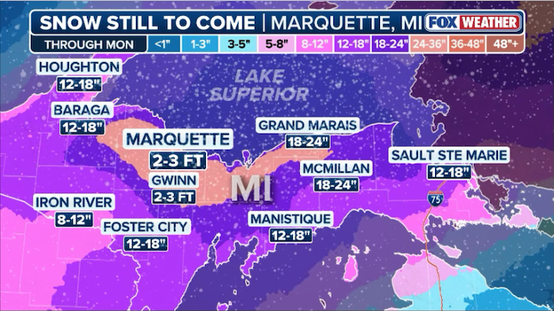
FOX Weather's snow forecast for how much additional snow is expected to fall through Monday.
Travelers planning to cross the Great Smoky Mountains tonight should prepare for a detour.
National Park Service officials have announced that US 441 (Newfound Gap Road), the main artery connecting Gatlinburg, Tennessee, and Cherokee, North Carolina, will close in both directions at 6:00 p.m.
The closure is a preemptive safety measure due to a High Wind Warning in effect for the higher elevations of the park.
The FOX Forecast Center is calling for sustained south winds of 25–40 mph, with potentially dangerous gusts up to 70 mph along the ridgelines tonight.
These conditions make travel treacherous for high-profile vehicles and significantly increase the risk of fallen trees and debris blocking the roadway.
If you need to travel between Tennessee and North Carolina tonight, you are urged to use Interstate 40 as your alternate route.
Park rangers will continue to monitor the wind speeds and road conditions throughout the night, but the road will remain closed until it is deemed safe for drivers.
The small community of Daggett in Michigan’s Upper Peninsula is also feeling the full force of the blizzard, recording 18 inches of fresh snow.
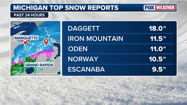
Latest top snow totals from Michigan.
This heavy accumulation is creating nearly impassable roads across Menominee County as strong winds continue to whip the snow into deep drifts.
Rib Mountain State Park in Wisconsin has been buried under 24-inches of snow as the blizzard 'bomb' slams the Badger State.
This two-foot total ranks as one of the highest in the region, turning the park into a winter wonderland while creating significant travel hazards for nearby Wausau.
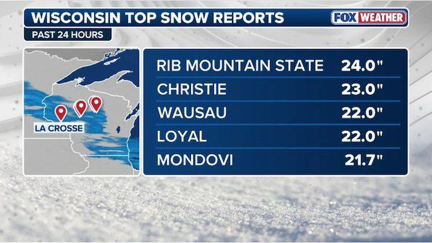
Latest top snow totals from Wisconsin.
Travel across the United States is grinding to a halt today as a massive and complex storm system creates chaos for the aviation industry.
According to the latest data from FlightAware, more than 7,200 flights have been disrupted so far, with cancellations topping 2,000 and delays climbing past 5,100.

FlightAware reports more than 7,200 flight disruptions across the U.S. through Monday.
This monster storm—which is bringing a mix of blizzard conditions to the North and severe thunderstorm outbreaks to the South—has forced airlines to cancel flights at several major hubs.
The most severe impacts are being felt at Minneapolis-St. Paul International (MSP), where a staggering 70% of the daily schedule has been wiped out due to whiteout conditions.
Major connection points like Chicago O'Hare (ORD) and Dallas-Fort Worth (DFW) are also seeing hundreds of delayed flights as severe storms and 60-mph wind gusts sweep through the heart of the country.
The combination of a powerful blizzard in the Midwest and a relentless Kona Low in the Pacific has triggered widespread power outages.
Latest power outage tracker showing state-by-state outages. (PowerOutage.com)
According to the latest tracking data from PowerOutage.com, over 400,000 customers are currently without power across the United States. This surge in outages comes as utility crews face the dangerous task of repairing lines in the midst of blizzard-force winds, torrential rain, and fast-moving wildfires.
- Ohio and Pennsylvania: The Great Lakes region is the epicenter, with Ohio (91,000+ out) and Pennsylvania (65,000+ out) leading the count. Crews are working to restore power from Friday’s windstorm as another round of strong winds threatens disruptions.
- Hawaii: The rare Kona Low has left a trail of destruction across the islands. While restoration is moving quickly, nearly 50,000 customers remain in the dark as landslides and flooding complicate access to damaged infrastructure.
- The High Plains: In Texas and Oklahoma, localized outages are being reported as high winds down poles and wildfires force emergency de-energization of lines to prevent further spread.
The Mackinac Bridge is currently closed to all traffic as a powerful late-season blizzard makes travel across the Straits of Mackinac impossible.
High winds and blowing snow have dropped visibility to near-zero, prompting the Mackinac Bridge Authority to suspend crossings for the safety of all motorists.

Courtesy: Mackinac Bridge Authority
The Authority is continuously monitoring wind speeds and visibility at multiple points along the structure.
While bridge personnel are working to reopen the link between Michigan's peninsulas as soon as it is safe, there is currently no estimated time for reopening as the storm's peak continues through the afternoon.
Tornado Watches are in effect for six states this afternoon as severe storms threaten millions.
Atmospheric conditions have reached a breaking point this afternoon as the National Weather Service issued Tornado Watches across six states in the path of the March's latest massive storm system.
The watch area currently blankets a massive corridor from the mid-Mississippi Valley into the Ohio and Tennessee Valleys, including portions of Illinois, Missouri, Arkansas, Oklahoma, Texas, and Louisiana.
Forecasters are warning that a rapidly consolidating line of storms will sweep eastward through the evening, bringing the potential for both embedded tornadoes and destructive straight-line winds.
The primary concern for meteorologists is the discrete nature of the storms forming ahead of the main line. These individual cells have the ability to tap into high-speed winds aloft, allowing them to rotate and potentially produce strong, long-track tornadoes (EF-2 or higher).
As the line matures into a solid squall tonight, the threat will shift toward widespread damaging wind gusts of 70+ mph, which can be just as dangerous as a tornado.
If you live in the watch zone, now is the time to ensure your FOX Weather App alerts are on and your "safe place" is ready, as these storms are moving at a fast clip of 50–60 mph.
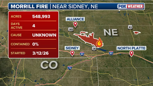
The Morrill Fire is burning across four counties in western Nebraska.
Firefighters across the state are battling what has officially become the largest wildfire in Nebraska’s history.
The Morrill Fire, which ignited Thursday, has now scorched more than 548,000 acres across four counties.
Fueled by 65-mph wind gusts from the same bomb cyclone system impacting the Midwest, the fire traveled an incredible 65 miles in just six hours after ignition, leaving a trail of devastation in its wake.
The human toll of the blaze has been tragic, with officials confirming that one person lost their life in Arthur County while attempting to flee the fast-moving flames.
Right now, the fire remains 0% contained as extreme wind conditions prevent crews from gaining the upper hand.
Governor Jim Pillen has declared a state of emergency and mobilized the National Guard to assist hundreds of volunteer firefighters from across the state who are working in heart-wrenching conditions.
With Fire Weather Warnings still in effect and the storm creating erratic wind shifts, the battle to save Nebraska's grasslands is far from over.
The Storm Prediction Center has issued a Tornado Watch for parts of Missouri and Illinois.
The National Weather Service has issued a Tornado Watch for the St. Louis metropolitan area and much of southern Missouri until 8:00 p.m. CT as a powerful cold front begins to ignite a line of intense thunderstorms.
This watch comes as the storm system shifts into its severe phase, bringing the threat of quick-spinning tornadoes and damaging straight-line winds to eastern Missouri and southwestern Illinois through this evening.
Atmospheric conditions are primed for rapid storm development, with forecasters particularly concerned about kinks or bends in the advancing squall line that could spawn tornadoes with little warning.
In addition to the tornado threat, wind gusts within these storms could reach 60 to 70 mph, capable of downing trees and power lines.
Once the storms pass this evening, residents should prepare for a dramatic weather whiplash—temperatures are expected to crash nearly 50 degrees overnight, turning today's storm threat into tomorrow morning's deep freeze.
As the massive March storm tracks east, the National Weather Service has issued a Wind Advisory for New York City and much of the Northeast corridor for Monday.
The FOX Forecast Center is warning that the region will see a dramatic shift as a powerful cold front approaches, bringing a one-two punch of soaking rain and potentially damaging wind gusts.
What to expect on Monday
While the morning may start with just scattered showers, conditions are expected to deteriorate rapidly by the afternoon and evening commute:
- The winds: Sustained southeast winds of 20–30 mph will increase, with gusts reaching 45 to 55 mph across the five boroughs, Long Island, and coastal Connecticut.
- The rain: Heavy rain of 1–2 inches is possible, which could lead to localized urban flooding and ponding on major roadways like the BQE and I-95.
- The impact: These gusts are strong enough to down tree limbs and power lines. Secure your outdoor furniture and umbrellas tonight, as the strongest winds will likely hit during the evening hours.
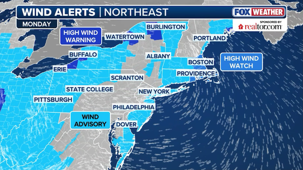
Wind alerts are in effect for more than 142 million Americans right now.
Farther north, cities like Boston are under a High Wind Watch, where even stronger gusts of up to 60 mph are possible. By Monday night, the wind will shift to the west as the cold front passes, ushering in the Arctic air that will put spring on pause for the rest of the week.
While much of the country is dealing with a massive winter storm, Florida is facing a much more typical March afternoon: scattered thunderstorms firing up along the sea breeze.
Even though these aren't part of a major organized system, the heat and high humidity (with dew points in the 70s) are providing plenty of fuel for these storms to pack a punch.
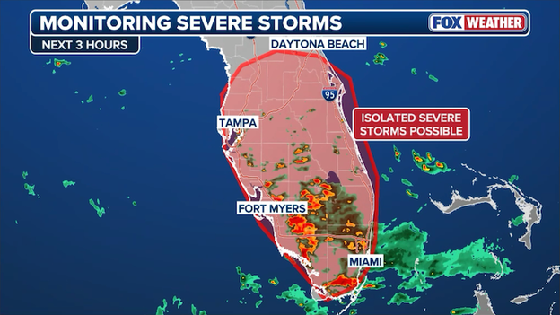
Isolated severe thunderstorms are possible across much of Florida this afternoon.
The Storm Prediction Center notes that while a widespread severe weather outbreak isn't expected, a few of these storms could become intense enough to produce damaging wind gusts and small hail.
Because the winds high up in the atmosphere are relatively light, these storms aren't likely to organize into a major line, so the threat will stay very localized.
The SPC does not expect to issue a formal Severe Thunderstorm Watch, but if you’re heading to the beach or out for a Sunday stroll in Miami or Orlando, keep an eye on the sky for those quick-developing, heavy downpours.
Power outages are mounting across the country this afternoon as a diverse array of weather threats takes a toll on the nation's energy grid.
According to the latest data from PowerOutage.com, there are currently more than 349,000 customers without power nationwide. The disruptions span from the tropical Pacific to the heart of the Midwest, driven by high winds, wildfires, and the lingering effects of Friday's windstorm.
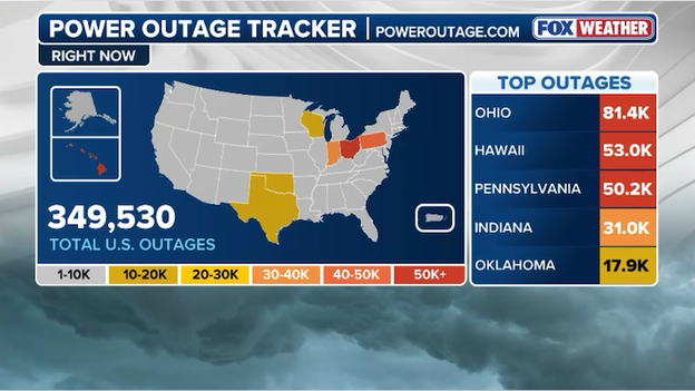
Latest power outage tracker showing significant outages across multiple states. (PowerOutage.com)
Travelers are facing significant challenges today as a powerful storm system brings a mix of blizzard conditions and severe weather to the center of the country.
According to the latest data from FlightAware, more than 2,000 U.S. flights have been canceled through Monday, with an additional 3,400+ delays impacting the national air network.
FlightAware MiseryMap showing huge disruptions at major airport hubs across America.
The combination of heavy snow in the North and a line of intense storms in the South has led to widespread groundings at several major hubs.
The epicenter of the disruptions remains in the Midwest, where over 700 flights have been scrubbed at Chicago's O'Hare International Airport due to whiteout conditions and ongoing snow removal efforts. Midway (MDW) is also experiencing a big delays as 60-mph wind gusts and thunderstorms move through the region.
Most major carriers have issued travel waivers to help passengers rebook as the storm moves toward the East Coast. Officials suggest checking flight statuses frequently, as the ripple effect of these 5,400+ disruptions is expected to continue into Tuesday.
Emergency officials have issued an immediate evacuation order for the town of Sayre, Oklahoma, as a large and destructive wildfire burns out of control.
The Oklahoma Department of Emergency Management reports that as of 11:42 a.m. CT, the fire was located approximately 3 miles north-northwest of Sayre and is spreading rapidly to the south-southeast.
Area of concern as severe thunderstorms erupt over the coming hours.
Severe weather is expected to ramp up quickly over the next hour or two as a powerful cold front triggers a line of intense storms across Missouri, Oklahoma, and Arkansas.
While the atmosphere has been capped or quiet so far today, the afternoon heat is finally breaking that lid, allowing storms to tap into high-speed winds just above the surface.
As this line pushes toward the Mississippi River by late afternoon, it could produce both damaging wind gusts and quick-spinning tornadoes.
Because the threat is developing so rapidly, the Storm Prediction Center is preparing to issue multiple Tornado Watches to cover the region through the evening hours.

A dangerous line of intense thunderstorms is expected to rapidly develop and sweep across the Mississippi, Ohio, and Tennessee Valleys this afternoon, bringing a widespread threat of damaging winds and tornadoes.
With the storm system strengthening, wind gusts could reach a destructive 60 to 80 mph along the leading edge of this squall line, while atmospheric conditions are becoming increasingly favorable for quick-spinning tornadoes—some of which could be strong (EF-2 or higher).
The Storm Prediction Center has expanded the severe weather threat zone across the Deep South through tonight.
The Level 3 of 5 risk zone has officially expanded into eastern Tennessee, western Georgia, and much of Alabama, as the threat is forecast to persist well into the night and early Monday morning for much of the Southeast.
Glancing out the window at a raging snowstorm may make you say, "Wow, it's a blizzard out there!" but it might not be a blizzard unless three crucial criteria are met.
First, it has to snow hard enough to reduce the visibility to less than 1/4 of a mile. That's just over 1,000 feet or roughly three football fields.
Second, the wind does not just blow but howls. The National Weather Service doesn't consider it an official blizzard until wind gusts reach at least 35 mph.
Finally, you need the first two criteria to last or expect it to last three hours or longer.
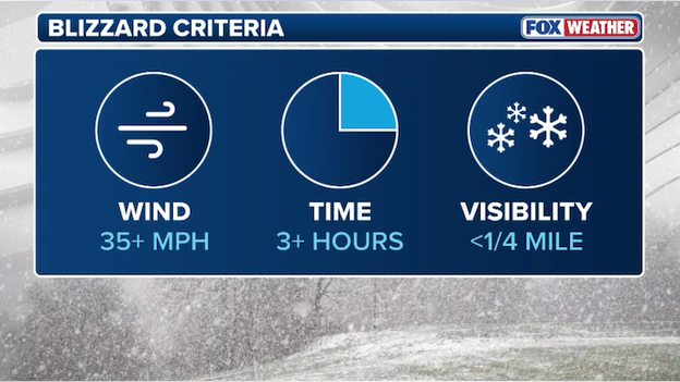
The National Weather Service has specific criteria for a "blizzzard."
Put all three together, and you have an official blizzard.
But it's not just falling snow that can create those whiteout conditions. Snow that has already fallen can be picked up and blown around by the wind, creating near-zero visibility. This can also create blizzard conditions.
Temperature and snow amounts are not considered in the definition, but you can surmise that both will also be a significant factor in most blizzards. If it's even close to freezing, and you add in 35 mph wind gusts, you're talking at bare minimum wind chills in the low teens. Most blizzards will be colder and windier with even lower wind chills.

The National Weather Service has issued an Ice Storm Warning for portions of northern Michigan.
While much of the Midwest is battling blizzard conditions, a different and more destructive threat is taking aim at the northern Lower Peninsula.
The National Weather Service in Gaylord has issued an Ice Storm Warning for a broad swath of Northern Michigan, stretching from Grand Traverse Bay northeast toward Presque Isle County.
Forecasters are warning of significant ice accumulations between 0.25 and 0.50 inches, with localized totals potentially even higher on elevated surfaces and power lines.

This ice zone is a direct result of the storm's powerful warm-air surge clashing with stubborn sub-freezing air trapped at the surface.
Combined with wind gusts of 40–50 mph, this heavy glaze is expected to cause widespread power outages and significant tree damage through Monday morning.
Travel is being strongly discouraged across the warning area, as even a tenth of an inch of ice can turn roads into skating rinks, and the current forecast suggests triple that amount for cities like Gaylord, Alpena, and Petoskey.
The record-breaking warmth that teased much of the country this week is about to be unceremoniously evicted.
Behind the massive storm, a powerful northwesterly flow is uncorking a reservoir of Arctic air, effectively putting spring on pause for over 230 million Americans.
Spring hits the "pause" button on Monday as cold Arctic air rushes south across America.
By Monday, temperatures across the Plains and Midwest will crash to 15–25 degrees below average, with highs struggling to leave the teens and 20s.
This freeze will dive all the way to the Mexican border, sending wind chills into the single digits for the North and the 20s as far south as Atlanta.
The cold snap will reach its peak on Tuesday, threatening to shatter over 30 record lows, some of which have stood for more than a century.
Major metros like St. Louis, Washington, D.C., and Atlanta will see afternoon highs languish nearly 30 degrees below their mid-March norms, likely remaining in the 30s for much of the day.
While the West Coast continues to bake under record heat, the eastern half of the country will be locked in a winter-like grip through Wednesday morning, when cities like New York and Boston wake up to temperatures in the shivering teens.
The scale of today’s historic storm is becoming staggering as 126 million Americans—nearly 40% of the U.S. population—are now under some form of wind alert.
From the snow-covered plains of the Dakotas to the humid bayous of the Gulf Coast, a massive swath of the country is bracing for gusts that could topple trees, down power lines, and make travel life-threatening.
More than 126 million Americans are under a wind alert right now.
High Wind Warnings are in effect for a massive corridor including Denver, Wichita, and Oklahoma City, where gusts could scream past 60 or 70 mph.
Meanwhile, Wind Advisories blanket nearly the entire Eastern half of the U.S., reaching as far south as San Antonio and Birmingham and as far east as Indianapolis and Nashville.
As of noon ET, more than 4,100 U.S. flights have been disrupted by the Midwest blizzard, according to the latest FlightAware data.
This massive jump includes 2,485 delays and 1,618 cancellations already logged through Monday, as the storm’s footprint expands to include the Great Lakes and the Ohio Valley.

FlightAware reports more than 4,100 U.S. flights have been disrupted by the extreme weather.
The situation is particularly dire at Chicago O’Hare (ORD), where high winds and nearby thunderstorms have triggered a ground delay program, with some travelers facing waits of nearly six hours.
Meanwhile, at Minneapolis-St. Paul (MSP), runway capacity has been slashed by relentless snow and whiteout conditions, leading to a cascade of cancellations for major carriers like Delta and Sun Country.
With severe thunderstorms and potential tornadoes also threatening southern hubs like Memphis, airlines are warning that the ripple effect of these 4,100+ disruptions will likely haunt the flight schedule well into the middle of the week.
In a world of high-tech modeling, sometimes the best tool is still a steady hand and a No. 2 pencil. A post on X has gone viral today, showing meteorologists at the Storm Prediction Center (SPC) hand-drawing analysis maps as a historic storm pummels the nation.
While radar, satellite, weather balloons, and sensors provide the data, these expert forecasters often return to hand-contouring pressure lines and fronts to better feel the physics of the storm, allowing them to spot subtle boundaries that automated computers might overlook.
This old school approach is a hallmark of the SPC during high-impact events, as the tactile process of drawing helps forecasters visualize exactly where the most dangerous wind and tornado threats are developing.
Reads Landing, Minnesota, has officially joined the ranks of the hardest-hit locations, recording a staggering 20.5 inches of snow as of this morning.
This massive total, reported along the Mississippi River in Wabasha County, highlights the extreme nature of the persistent snow bands that have stalled over the region.
Latest top snow totals from Wisconsin
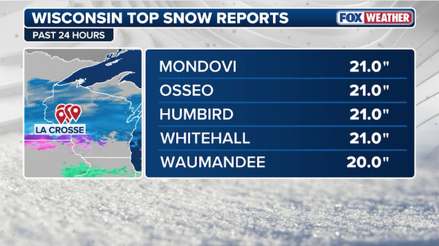
Mondovi, Wisconsin, is now emerging as one of the standout snow totals of this storm, recording a massive 21.0 inches as of this morning.
Located in Buffalo County, Mondovi has been sitting directly in a persistent, heavy snow band that has refused to budge, pushing totals well past the two-foot mark in localized drifts.
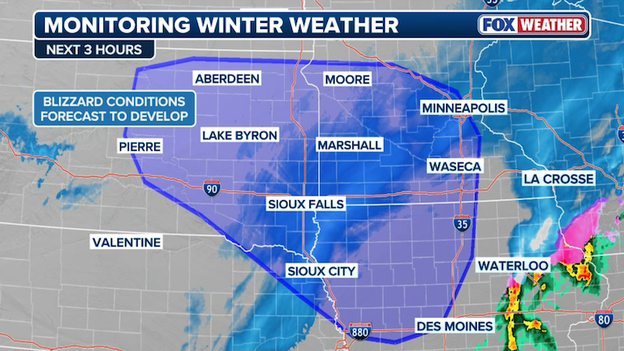
Blizzard conditions are expected to develop and expand across the central U.S. through this evening.
A massive storm system is rapidly strengthening over the heart of the country this afternoon, creating a dangerous blizzard.
As winds intensify late this morning and into the afternoon over the Northern Plains and upper Midwest, the wind will combine with falling snow to create a full-blown blizzard.
Right now, visibilities are dropping over parts of South Dakota and are expected to dip dangerously low (less than 1/4 mile), creating blowing snow and blizzard conditions through much the today.
Later today into this afternoon, the strong winds and blowing snow are forecast to expand across parts of Iowa where travel could become hazardous tonight.
Memphis is on high alert this evening as a potent cold front triggers a Level 3 of 5 for severe weather.
The FOX Forecast Center expects a dangerous line of storms to sweep through the metro area between 5:00 p.m. and 8:00 p.m., bringing the threat of destructive straight-line winds reaching up to 75 mph and embedded, quick spin-up tornadoes.
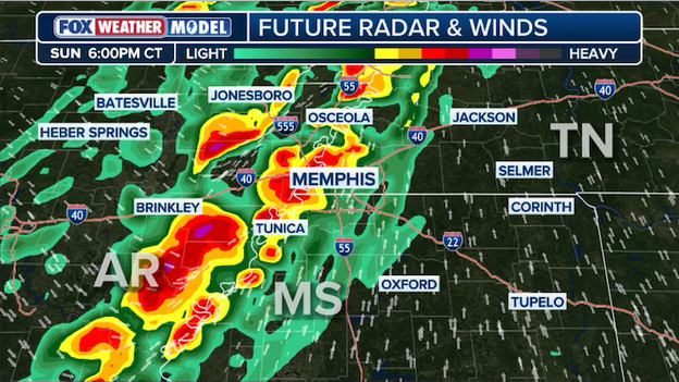
Exclusive FOX Weather Model showing the timing of dangerous storms hitting Memphis later today.
Residents are being urged to secure loose outdoor items and finalize their safety plans before the dinnertime window, as the environment is primed for significant intensity.
Adding to the volatility, temperatures are expected to plummet by nearly 40 degrees immediately following the storm's passage, shifting the region from tropical humidity to a hard freeze by morning.
The blizzard is set to rage across the Upper Midwest through Sunday night as the powerful storm shifts into its most intense phase.
Right now, the exclusive FOX Weather Model shows a dangerous combination of heavy snow and wind gusts reaching 50–60 mph from Minneapolis down to Sioux Falls and Kansas City, which will continue to trigger widespread whiteout conditions and drifting.
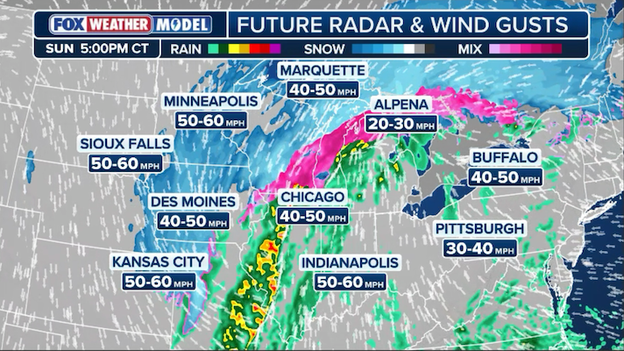
Exclusive FOX Weather Model showing where heavy snow will combine with intense winds this evening to create whiteout conditions.
As the system pulls eastward tonight, cities like Des Moines, Chicago, and Indianapolis will be caught in the crosshairs of the transition zone, facing a punishing mix of rain, ice, and high winds.
With gusts expected to stay above 40 mph through the overnight hours, travel will remain life-threatening across the heart of the country well into Monday morning.
The sheer power of this storm is on full display today as it creates a dramatic, high-stakes weather divide across the Heartland.
In Iowa, residents are facing Severe Thunderstorm Warnings for intense rain and damaging winds, while a mere 40 miles away, the atmosphere is cold enough to transform that same moisture into a major blizzard.
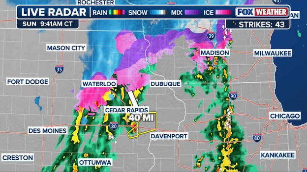
Radar showing where Severe Thunderstorm Warnings are just 40 miles away from where the rain transitions to snow.
This narrow transition zone highlights the extreme energy of the storm, where spring-like severe weather and a full-blown winter emergency are separated by less than an hour's drive.
It’s a vivid example of the battle of air masses that makes this storm so historic.
The small town of Millville, Minnesota, has been blanketed by 17.0 inches of snow, marking it as one of the hardest-hit spots in the state during this historic March blizzard.
Situated in the Zumbro River Valley, Millville is sitting directly under an intense snow band that is dumping several inches per hour, quickly surpassing the foot-and-a-half mark this morning.
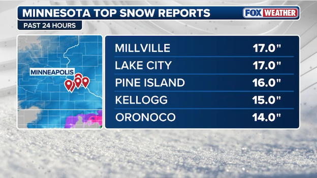
Latest top snow totals from Minnesota.
Conditions in Wabasha County have been described as "treacherous" by local authorities, as the heavy snow combined with wind gusts of nearly 50 mph has led to widespread whiteouts and drifting.
For a town that usually sees its heaviest snow earlier in the winter, this 17-inch wallop serves as a stark reminder that March in Minnesota often saves its biggest punch for last.
Nelson, Wisconsin, has now checked in with a staggering 19.0 inches of snow as the heaviest snow tracks directly across Buffalo County.
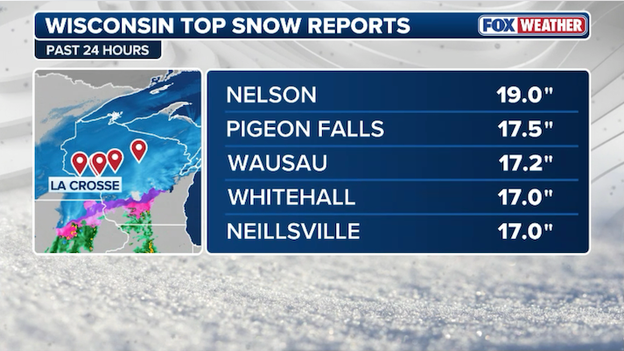
Latest top snow totals from Wisconsin.
If it feels like the weather has shifted into overdrive lately, you aren't imagining it. From record-shattering warmth in the South to deadly tornadoes in the Heartland and 4-foot snowfalls in the Great Lakes, March 2026 is proving to be a month of historic volatility.
According to the FOX Forecast Center, several powerful natural drivers are colliding to create this high-energy pattern.
The primary engine behind this month’s wild swings is a major disruption of the Polar Vortex. Often misunderstood as a single storm, the Polar Vortex is actually a massive, high-altitude "fence" of spinning air that normally keeps frigid Arctic air trapped at the North Pole.
This month, a Sudden Stratospheric Warming event (SSWE) caused that fence to buckle and collapse. When the vortex wobbles or breaks apart, it acts like a hand pushing down on the jet stream, the high-altitude primary driver of our day-to-day weather, forcing it to meander in deep, violent loops.
This wavy jet stream is exactly what allows a 90-degree heat dome to park over the Southwest while simultaneously pulling a bomb cyclone and Arctic air into the Heartland.
March is also the ultimate battleground month. As the sun gets higher in the sky, it begins to bake the Southern Plains and the Gulf of America, while the Arctic remains locked in deep winter.
This year, the contrast is particularly stark. We have seen record-high temperatures—up to 35°F above average—immediately followed by bomb cyclones. When these two extremes meet, the atmosphere works violently to balance the temperature difference, resulting in the massive squall lines and blizzard conditions we are witnessing today.
Abundant moisture flowing off the Gulf of America is helping fuel severe storms in the central U.S.
The fuel for our recent severe weather outbreaks is coming directly from the Gulf of America, where sea surface temperatures are currently at or near record highs for mid-March. This warm water acts like a high-octane battery, pumping significant moisture and heat into the lower atmosphere.
This excess energy is a primary reason why we are seeing rare phenomena like thundersnow in the North and long-track tornadoes in the South; the storms simply have a deeper reservoir of energy to tap into as they develop.
And when a powerful jet stream interacts with these warm-and-cold boundaries, it can trigger bombogenesis—a rapid drop in atmospheric pressure. This process effectively "vacuum-seals" the storm, causing it to tighten and intensify at a staggering rate.
These bomb cyclones are responsible for the 70-mph straight-line winds and the impossible blizzard conditions currently paralyzing the Midwest right now.
Delays are averaging over 5 hours at Chicago O'Hare International Airport this morning.
Travel headaches are worsening at Chicago O'Hare as a fresh ground delay program has pushed average arrival delays over five hours this morning.
The Federal Aviation Administration reports that thunderstorms are significantly reducing the airport's arrivals and departures, leaving thousands of passengers stranded during one of the busiest travel weekends of the month.
The brutal blizzard has effectively paralyzed central Wisconsin this morning as intense snow bands dump 1 to 2 inches of snow per hour on major highways.
With wind gusts reaching 50 mph creating instant whiteout conditions, the Wisconsin Department of Transportation is warning that travel is nearly impossible and should be restricted to emergencies only.
The Steele County 911 Center has issued an urgent "no travel" alert, pleading with residents to stay off the roads as blizzard conditions make driving life-threatening in Minnesota.
Officials warn that visibility has dropped to zero and any travel is currently restricted to emergencies only to allow crews to focus on essential rescues.
The travel trouble is accelerating this morning as the blizzard bomb intensifies over the Midwest.
As of 9:30 a.m. ET, more than 2,500 U.S. flights have already been disrupted through Monday, according to the latest data from FlightAware.
FlightAware MiseryMap showing the flight disruptions across the United States.
This staggering total is split almost evenly between 1,267 delays and 1,268 cancellations, with those numbers expected to rise sharply as the core of the storm moves through the Great Lakes.
The heaviest impact remains focused on the Upper Midwest, where Minneapolis-St. Paul International (MSP) continues to see the most significant disruptions, followed closely by Chicago O’Hare (ORD).
While snow and whiteout conditions are the primary culprits in the North, the ripple effect is being felt nationwide as airlines struggle to reposition aircraft and crews ahead of the severe weather outbreak pushing toward the East Coast.
Travel has been brought to a complete standstill across much of South Dakota as blizzard conditions turn major thoroughfares into whiteout zones.
The South Dakota Department of Transportation has taken the extraordinary step of closing hundreds of miles of interstate, citing impossible driving conditions caused by heavy snow and intense wind gusts.
As of Sunday morning, the following major closures remain in effect with no estimated time for reopening:
- Interstate 90: Closed in both directions from Sioux Falls to Wall (a stretch of nearly 300 miles).
- Interstate 29: Closed in both directions from Sioux Falls to the North Dakota state line.
Interstates 29 and 90 are closed in South Dakota right now due to the blizzard.
Officials warn that bridges and underpasses are becoming blocked by massive drifts, and visibility is frequently dropping to zero.
In addition to the highway closures, Sioux Falls Regional Airport has shut down entirely, a rare move that underscores the severity of this blizzard
Motorists are being strictly advised not to use secondary highways to bypass these closures, as stranded vehicles only hinder emergency and snow removal efforts.
Oronoco, Minnesota, is the latest community to be buried under heavy snow, officially recording 14.0 inches as the blizzard slams the region.
This massive total comes as intense snow bands continue to dump several inches per hour, making travel nearly impossible across southeast Minnesota.
Latest top snow reports from Minnesota.
Snow reports are beginning to pour in as the blizzard intensifies, with the highest accumulation currently recorded at 14.9 inches in Montana, Wisconsin.
Located in Buffalo County, Montana is sitting in a prime corridor for heavy banding, where snow has been falling at a rate of nearly 2 inches per hour this morning.
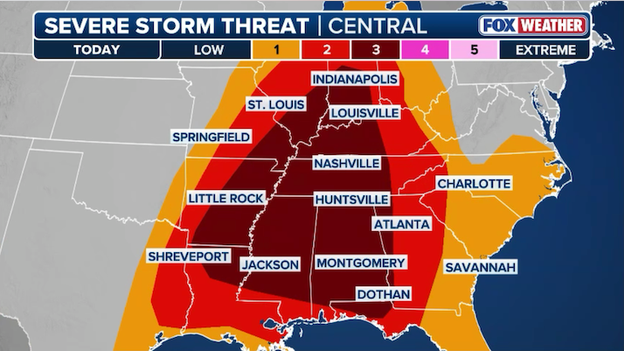
While the Midwest digs out from the blizzard, the East Coast is bracing for a rare and dangerous severe weather outbreak on Monday.
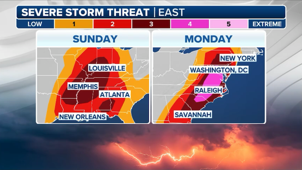
The FOX Forecast Center warns that the threat level has been upgraded to a rare Level 4 out of 5 for a large corridor including Washington, D.C., and parts of Maryland, Virginia, and the Carolinas. This is a serious and uncommon alert for the region, signaling that widespread, intense storms are likely to cause significant damage.
Dangerous ingredients coming together
The atmosphere over the East Coast will be highly energized tomorrow. As a deep storm system pivots toward the Atlantic, it is pulling up warm, humid air that will collide with extreme wind speeds just above the ground.
Meteorologists are tracking extreme shear profiles, which essentially means the winds are changing speed and direction so rapidly that they will easily cause storms to spin. This setup is a classic recipe for powerful tornadoes and long-lived supercell storms that can travel hundreds of miles.
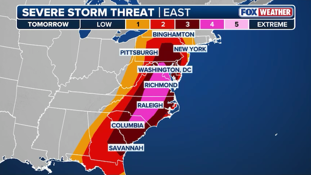
A rare Level 4 of 5 threat zone has been issued for portions of the East Coast on Monday.
What to expect: Tornadoes and 75-mph winds
For residents from Georgia all the way to Pennsylvania, Monday afternoon will be the most critical window. Two main threats are developing:
- Strong, long-track tornadoes: Conditions are particularly favorable from South Carolina into southern Virginia for supercells that could produce strong tornadoes capable of staying on the ground for a long time.
- Destructive wind line: A robust line of storms will charge east toward the coast, packing particularly damaging winds. Expect gusts to exceed 70–75 mph, which is strong enough to snap large trees and cause widespread power outages across major metro areas.
Timing your Monday
The activity will start early in the morning across the Florida Panhandle and Georgia before intensifying and spreading north throughout the day.
The peak of the event for the Mid-Atlantic and Northeast—including cities like Philadelphia and Baltimore—is expected during the late afternoon and early evening hours.
Because these storms will be moving fast (over 50 mph), you may have very little time to react once a warning is issued. Make sure you download the FOX Weather App now and enable critical weather alerts so you can be alerted to severe weather, even while you're sleeping.
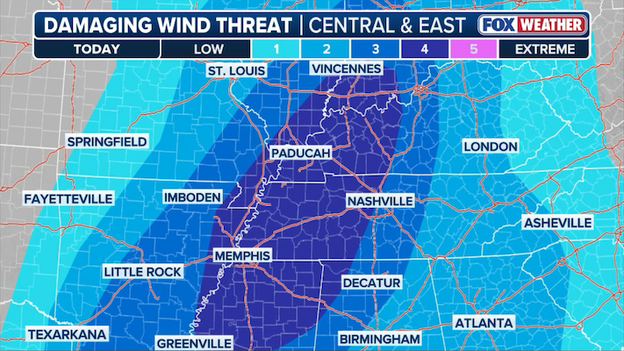
The Storm Prediction Center says the highest threat for damaging winds extends from Indiana to Mississippi later today.
The FOX Forecast Center is tracking a powerful squall line—a long wall of intense thunderstorms—that is expected to ignite this afternoon and race from the Mississippi Valley toward the Appalachians.
The primary threat with this system is destructive straight-line winds, which are expected to peak across northeastern Arkansas, southeastern Missouri, southern Illinois, western Kentucky, and Tennessee.
FOX Weather meteorologists warn that while widespread gusts of 60 mph are likely, the most intense parts of the line could see hurricane-force winds exceeding 75 mph, capable of snapping power poles and causing significant property damage.
The danger will increase between 2:00 p.m. and 4:00 p.m. CT as the storms quickly organize and charge eastward. While the wind is the main event, small but intense tornadoes could also spin up along the leading edge of this fast-moving line.
The threat remains high through the evening hours, eventually shifting into the Deep South overnight.
Thousands of residents across the Midwest and Northeast are still struggling in the dark following Friday’s vicious windstorm, and for many, the situation is about to get much worse.
According to PowerOutage.com, nearly 270,000 customers across the U.S. remain without electricity this morning. This number also includes significant outages in Hawaii due to a Kona Low hammering the islands and preemptive power shutoffs in Colorado due to the threat of wildfires.
Latest power outage tracker showing significant outages at this hour in the Great Lakes. (PowerOutage.com)
Ohio and Pennsylvania are currently bearing the brunt of these outages, with more than 140,000 combined customers still waiting for the lights to come back on after Friday's damaging gusts snapped poles and downed lines.
The timing couldn't be worse for these recovery efforts. As crews work to restore power from the previous storm, the new bomb cyclone is already beginning to lash these same regions. In Michigan and Ohio, where more than 100,000 people remain without power, the forecast now calls for a mix of heavy snow and freezing rain.
This fresh accumulation on already weakened trees and saturated soil will likely lead to a second wave of widespread outages through Monday.
The massive blizzard tearing through the nation’s midsection isn't just a headache for drivers; it’s creating a full-scale meltdown for air travel.
According to FlightAware, more than 2,130 flights have already been disrupted through Monday as heavy snow, ice, and fierce winds make it impossible for many major hubs to operate safely.
FlightAware reports more than 2,100 U.S. flights have already been disrupted by the massive storm through Monday.
Minneapolis and Chicago bear the brunt
As the center of the blizzard hammers the Upper Midwest, Minneapolis-St. Paul International (MSP) has become the epicenter of the travel chaos.
With over 600 cancellations already on the board today, the airport is struggling to keep runways clear amidst snow rates of 2 inches per hour.
Farther south, Chicago’s O’Hare (ORD) and Midway (MDW) are facing a double-edged sword: dealing with the blizzard's wind gusts to the north and the threat of severe thunderstorms to the south. Combined, the two Chicago hubs have seen nearly 250 cancellations as the storm system sweeps through the Great Lakes.
A ripple effect from the Heartland to the South
The disruptions aren't limited to the snow zone. Atlanta (ATL), one of the world's busiest airports, is already seeing nearly 100 delays and cancellations as the storm's severe weather side brings the threat of tornadoes and 70-mph winds to the South.
Travelers are being urged to check their flight status before heading to the airport, as the conveyor belt of severe weather is expected to keep flight boards lit up with red canceled text well into Monday night.
The FOX Forecast Center warns that as a powerful low-pressure system rapidly intensifies, it will collide with cold Canadian air to dump staggering totals, including 12–18 inches in Minneapolis, up to 2 feet in Green Bay, and a massive 3–4 feet in Marquette, Michigan.
Latest snow forecast from FOX Weather showing where more than 2 feet of snow is expected.
With powerful wind gusts of 60–70 mph expected to create blind whiteouts and widespread power outages, Blizzard Warnings now cover more than 11 million Americans from the Dakotas to Illinois.
While the heaviest snow hammers the north, dangerous ice is expected in areas like Milwaukee and Traverse City, where up to half an inch of freezing rain could coat power lines and roads, paralyzing the region well into the start of the work week.

Radar analysis shows bands of heavy snow moving northward over the Upper Midwest this morning.
Southeast Minnesota, central Wisconsin, and the Upper Peninsula of Michigan are getting hammered this morning with intense, high-impact snow.
The FOX Forecast Center warns that bands of snow are acting like a fire hose over the region, dumping 1 to 2 inches of snow per hour in the heaviest bursts.
This extreme rate is enough to bury car tires in just a few hours and is creating dangerous whiteout conditions for drivers on major interstates.
Lightning detection networks indicate multiple lightning strikes over southeast Minnesota where intense snow is falling this morning.
Residents in southeast Minnesota are being treated to a rare and dramatic weather phenomenon this morning as thundersnow accompanies the arrival of a massive bomb cyclone.
Reports of lightning flashes and loud claps of thunder during intense snow bursts have surfaced along the I-90 corridor, particularly near Rochester and Winona, as the storm system rapidly intensifies over the region.
More than 200 million Americans are facing the threat of strong tornadoes, destructive winds, and large hail through Monday.
A massive and dangerous weather system is putting more than 200 million Americans on high alert. The FOX Forecast Center warns that a significant severe weather outbreak is brewing, threatening a huge swath of the country from the Heartland all the way to the Atlantic coast.
As a powerful bomb cyclone cranks up over the Midwest, it is pulling a surge of warm, unstable air from the Gulf of America, setting the stage for a volatile 48 hours of strong tornadoes and destructive winds.
Severe threat shifts from the Heartland to the East Coast
The setup for today is widespread and intense as the storm system marches from the Great Plains toward the Great Lakes. The Storm Prediction Center has placed a Level 3 out of 5 risk over the Mid-South and Ohio Valley for Sunday, focusing on cities like Nashville, Indianapolis, Memphis, Louisville, and Little Rock.
The primary concern for most will be a fierce squall line of thunderstorms packing straight-line winds over 70 mph—strong enough to flip semi-trucks and snap power poles.
However, the atmosphere is also primed for spinning storms, meaning tornadoes could embedded within that line or develop as individual, discrete storms ahead of it.
Major risk looms for the I-95 corridor Monday
As the system moves east, the danger level actually climbs. For Monday, the threat has been upgraded to a Level 4 out of 5, a rare and serious designation that now includes Washington, D.C. and surrounding metro areas.
Forecasters are increasingly concerned about the potential for long-track tornadoes—those that stay on the ground for several miles—and even more widespread wind damage.
This isn't just a one-and-done storm; it is a continuous conveyor belt of severe weather that won't let up until late Monday night.
Critical timing: afternoon starts and overnight dangers
The clock starts this afternoon between 2:00 p.m. and 4:00 p.m. CT, when the first storms are expected to fire up and quickly organize into a solid wall of weather.
A particularly dangerous phase of this event will occur late tonight as the threat shifts into the Deep South. While the main line hammers the north, separate and powerful supercell thunderstorms could develop across the Florida Panhandle, southeastern Alabama, and Georgia during the overnight hours.
This nighttime threat is especially risky, as tornadoes are harder to see and many people may be asleep when warnings are issued.
Millions of Americans are waking up to urgent weather alerts this morning as a massive bomb cyclone begins its assault on the heart of the country.
With approximately 22 million people currently under winter weather alerts, officials are warning that the combined force of record-breaking snow and hurricane-force wind gusts could effectively shut down large swaths of the Upper Midwest and Northern Plains through Monday.
The "bomb" explodes timing and intensity
The storm system, which is undergoing rapid bombogenesis via a sudden and extreme drop in atmospheric pressure, is currently centering its power over the Upper Mississippi Valley.
Meteorologists warn that the worst is yet to come for residents in Minnesota, Wisconsin, and the Dakotas as blizzard conditions reach their height from Sunday afternoon through early Monday morning.
Snow will fall at rates of 2–3 inches per hour in the most intense bands, while gusts of 50–70 mph will create blinding whiteout conditions that will reduce visibility to zero on major transit corridors like I-90 and I-94.
Millions in the crosshairs
The scale of this event is staggering, stretching from the eastern Dakotas to Northern Michigan. Some states are advising everyone to not venture outside, with the Twin Cities and Green Bay bracing for up to 20 inches of snow.
In parts of Northern Michigan, lake-enhanced totals could reach a historic 3 feet, while the Northern Plains face life-threatening wind chills alongside nearly a foot of fresh accumulation.
Blizzard Warnings are in effect for more than 11 million Americans, including Minneapolis.
You’ve reached the beginning of this live coverage.