What's falling from the sky right now? How you can help researchers
Mountain Rain or Snow is an app to help improve understanding of the rain-snow transition temperature in mountain regions.
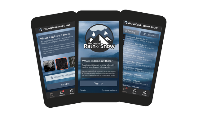
Help scientists decipher what type of precipitation is falling.
(Mountain Rain or Snow)
Forecasting for a winter weather event can be challenging, especially when temperatures hover around the freezing mark and there is changeover from snow to rain. This becomes especially difficult in mountains as the higher elevations make it harder to forecast, and few weather stations can accurately identify the precipitation type. Because of this difficulty, a group of scientists created an app to help identify precipitation that is falling.
Mountain Rain or Snow is an app to help improve understanding of the rain-snow transition temperature in mountain regions.
The app, funded by NASA, relies on people to identify whether it is raining, snowing or a mixture of both.
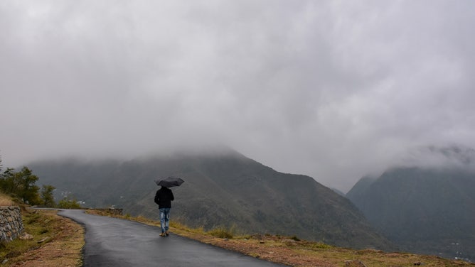
A man walks with an umbrella during a rainfall.
(Saqib Majeed/SOPA Images/LightRocket via Getty Images / Getty Images)
Inconsistent temperatures within mountainous regions make it hard for forecasters to anticipate whether the precipitation falling is rain or snow. The precipitation phase can vary over the course of minutes and across short distances.
Because of this difficulty, scientists behind the app are working to help make this forecasting easier.
"The transition from rain to snow is notoriously difficult to predict, even for weather forecasters. This is especially true in the mountains," Meghan Collins, Education Program Manager for the Desert Research Institute, says. "In arid regions across the U.S., improved estimates of rain and snow near the freezing point make a big difference for understanding how much precipitation falls in winter, as well as estimating risks like avalanches and floods."
Collins' team is working to improve satellite remote sensing data and hydrologic models to better estimate what type of precipitation falls during winter storms.
They say that despite the critical differences between rain and snow, they have few visual observations of precipitation type, particularly in the mountains.
"Your reports will help us and other scientists improve remote sensing products and hydrologic models to better estimate what type of precipitation falls during winter storms. This information improves our ability to estimate how much water is available for later use, reduce flood hazards, and better predict good skiing conditions," Collins says.
To better forecast these uncertainties, they need the public's help.
Scientists for the app say that human observers are the best resource for discovering how precipitation phase varies in time and space.
"Our very own eyes are the best tools we have for identifying whether it is raining, snowing, or mixed precipitation. So crowdsourcing observations of winter weather with community members bring a very powerful element to this project," Lynker scientist Keith Jennings says.
The team says that crowdsourcing observations of winter weather with community members bring a powerful element to this project.
"Our hope is that the more observations we get, the more utility we'll provide to remote sensing scientists, flood modelers, weather forecasters, avalanche awareness groups, and the community as a whole," Jennings says.
And not only will these observations help forecasters, but other scientists too.
"We also are working closely with NASA scientists to see how our data can help improve satellite-derived estimates of rain and snow," says Jennings. "By providing a large number of observations in space and time, we may be able to provide ancillary information to the satellite products that can be used to better predict where rain and snow are occurring in the mountain ranges that are critical to water resources in the western and northeastern U.S."
How you can help
Start reporting with the Mountain Rain or Snow app when the storm changes from rain to snow or snow to rain.
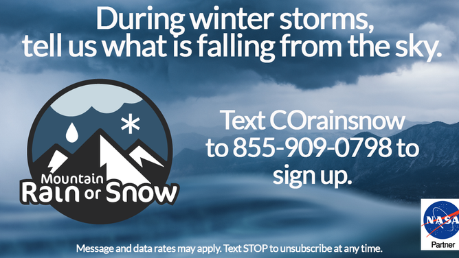
Participants can text a keyword unique to their region (the keyword for the Northeast is NorEaster) to 855-909-0798, and that subscribes them to our text message community. We share the web app and the basics on how to participate. Then, we send alerts when winter storms are moving through as a way to connect our observers.
(Mountain Rain or Snow)
Jennings says that they are taking the observations and hoping to release a semi-live dashboard this winter that "tracks observations in near real-time so that volunteers and anyone else who's interested can track rain, snow, and mixed precipitation across our study domains: The Appalachians and Adirondacks of New England and New York, the Rockies in Colorado, the Cascades and other Oregon ranges, and the Sierra Nevada of California and Nevada."
The more observations that are recorded, the better the science will be.
"Our hope is that the more observations we get, the more utility we'll provide to remote sensing scientists, flood modelers, weather forecasters, avalanche awareness groups, and the community as a whole. That will enable us to secure more funding and expand our scope to more areas of North America and perhaps beyond," Jennings says.