Why the eastern Caribbean is known as the 'hurricane graveyard'
The Caribbean Sea, Gulf of Mexico and Atlantic Ocean make up what is known as the Atlantic basin. The warmest water temperatures in the entire basin are found in the Caribbean Sea and contribute to some hurricanes that rapidly strengthen, while others have difficulty coalescing around a center of circulation.
What is the hurricane graveyard in the Caribbean?
Some potential tropical cyclones struggle to develop in the eastern Caribbean while others weaken despite warm waters.
The Caribbean Sea is known for its warm waters, island life and bountiful marine life, but meteorologists commonly refer to the region of the Atlantic basin as the "hurricane graveyard."
Tropical disturbances traveling from the central Atlantic pass through the Lesser Antilles to enter the Caribbean Sea, but for reasons that aren’t entirely understood, many systems struggle to develop.
Tropical Storm Gonzalo (2020), Tropical Storm Kirk (2018), Hurricane Isaac (2018), Tropical Storm Bret (2017), Hurricane Danny (2015) and Tropical Storm Erika (2015) are all recent examples of systems that struggled in the eastern Caribbean and, in many cases, underperformed computer forecast models.
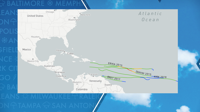
Tropical Cyclones that have weakened in the Caribbean Sea.
A study published in the journal Bulletin of the American Meteorological Society tried to nail down reasons why minimal tropical cyclogenesis occurs over the eastern Caribbean Sea, and researchers came up with several theories.
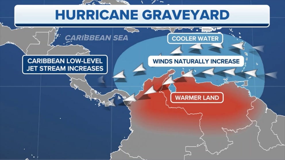
Authors stated a persistent level of divergence created by the wind flow is likely the main culprit for a lack of tropical development.
Complexes of showers and thunderstorms need an area of convergence - the opposite of divergence – for the warm, humid air to be dragged up into towering clouds.
For decades, forecasters have observed several features that make the eastern Caribbean unpredictable at times when it comes to cyclones being born.
The eastern Caribbean is known as the "hurricane graveyard"
(FOX Weather)
HERE’S WHY ATLANTIC HURRICANE SEASON RUNS FROM JUNE TO NOVEMBER
Dry air/lack of moisture
In addition to a rather stubborn amount of divergence, occasionally, periods of the Saharan air layer (SAL) or what is known as African dust make it into the Caribbean.
The air layer is known to decrease visibilities and, more importantly, for cyclones, reduce moisture.
Experts say the air has about 50% less moisture than the typical atmosphere, which means the presence of air can be detrimental to tropical cyclone activity.
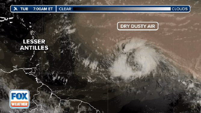
This image combines the visible satellite with the NASA GOES model dust contour. This shows forecasters the hostile environment to the north and west of Tropical Storm Bret.
(FOX Weather)
Wind shear
During El Niño years, stronger westerly winds are commonly found over the Caribbean due to its proximity to the Pacific Ocean.
These winds increase vertical wind shear and, if strong enough, can shear the tops off of developing thunderstorms.
Tropical cyclones need consistent thunderstorm activity to form an organized low-pressure center, meaning that large parts of the sea are hostile for development.
7 FACTS TO KNOW ABOUT HURRICANES
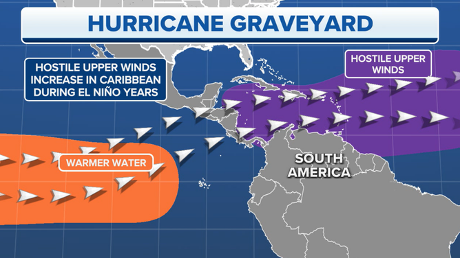
El Niño impacts on Caribbean cyclones
(FOX Weather)
High terrain
At least 20 mountains have peaks above 3,000 feet across the Caribbean, which can help to tear cyclones apart and lead to a hurricane’s circulation being disrupted.
Higher elevations tend to have cooler, drier air which can lead to less cloud coverage and available moisture.
Many of the region's highest mountain tops are on the island of Hispaniola, with Pico Duarte reaching 10,174 feet above sea level.
The Dominican Republic summit ranks among some of the highest elevations in the world.
Numerous tropical cyclones have made landfall on the island of Hispaniola and have weakened tremendously until they were free from the effects of friction.
Low latitude
The further one travels from the equator, the greater the Coriolis force will be due to Earth’s spin.
The effects of the spin of the globe are greatest at the poles and are minimal at the equator, and without it, cyclones would not form.
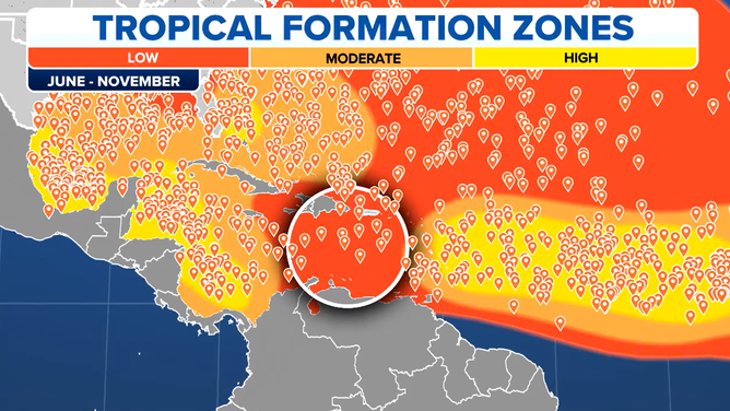
Because the force is minimal around the globe's center, cyclones do not form within about 5 degrees latitude of the demarcation.
Tropical cyclogenesis in the Atlantic basin is minimal between 5 degrees North latitude and about 8 degrees North latitude.
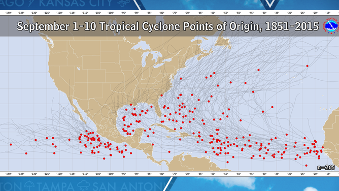
Tropical cyclone points of origin during the peak of hurricane season.
Most of South America and parts of Central America sit below 10 degrees North latitude, meaning that the Coriolis force is minimal compared to other regions of the Atlantic basin.
Hurricane Matthew of 2016 holds the record for being the strongest cyclone at the lowest latitude. The Category 5 hurricane reached 13.4°N during its trek through the Caribbean.
In recent years, Tropical Storm Kirk in 2018 was one of the furthest southern-forming cyclones in the basin. Kirk formed at a latitude of 8.1°N, which was one of the furthest southern points in the satellite era.