How extremely warm Gulf of Mexico waters can lead to monstrous storms
Storms in the Gulf sometimes undergo a process called ‘rapid intensification’
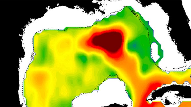
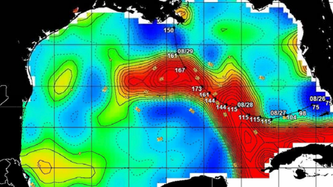
The deep, warm waters of the Gulf Loop Current are depicted in dark red in this Aug. 25, 2021.
Tropical systems that enter the Gulf of Mexico can sometimes have an ample supply of the fuel they need to grow – extremely warm water.
While there are many different ingredients for the formation of a tropical system, warm water is one of the main components. The minimum water temperature for the development of a tropical system is about 80 degrees.
"If you have 26 (degrees Celsius), 79 (degrees Fahrenheit) up or above, chances are that if the atmospheric conditions are appropriate, you can create a hurricane or a tropical cyclone, you know, depression," said Gustavo Goñi, an oceanographer at the National Oceanic and Atmospheric Administration’s Ocean Service.
The Gulf of Mexico is an abundant source of water that is much warmer than that minimum temperature, with an average water temperature during hurricane season (June to November) into the mid-80s. In August and September, typically the busiest time of the Atlantic hurricane season, water temperatures can climb into the 90s in the southern Gulf and approach the upper 80s in the northern Gulf.
What drives the warm water?
The Gulf acts as a basin where hot water from the Caribbean Sea brought north by the Loop Current collects.
The Loop Current runs up from the Caribbean Sea between the Yucatan Peninsula of Mexico and the western tip of Cuba before swirling clockwise around the central Gulf and moving back out to the Gulf Stream in the Florida Straits.
"In the Gulf of Mexico, the deepest areas of warm water are associated with the Loop Current, and the rings of current that have separated from the Loop Current are commonly called Loop Current eddies," said FOX Weather meteorologist Greg Diamond. "The warm waters of the Loop Current and its associated eddies provide more energy to hurricanes and allow them to intensify."
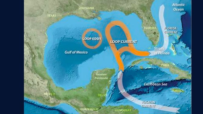
This graphic from NOAA demonstrates the Gulf Loop Current and the eddies that develop from it.
(NOAA)
How do storms interact with the warm water?
Hurricane Grace in 2021 was fed by the warm waters of the Gulf and led to a rapid intensification of the storm. Grace had weakened quite a bit while moving over the Yucatan Peninsula. However, once it emerged in the southern Gulf of Mexico, the storm quickly regained hurricane strength. It jumped a full two categories in just hours as it moved across the Bay of Campeche. It made landfall in the Mexican state of Veracruz as a Category 3 hurricane with winds of 125 mph.
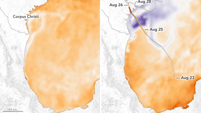
In 2020, Hurricane Laura underwent rapid intensification before it made landfall in Louisiana as a Category 4 storm. According to NASA, waters in the Gulf were running about 2 degrees above average. Laura’s winds increased by 50 mph in just 24 hours, according to NASA.
This map shows the sea surface temperatures on Aug. 25, 2020, during Hurricane Laura.
(NASA)
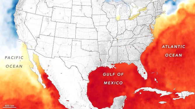
Hurricane Harvey in 2017 also underwent rapid intensification as it approached the Texas coastline. According to NASA, Harvey moved into waters that were 2.5 to 7 degrees above average. It made landfall as a Category 4 storm with winds of 130 mph.
This map shows the sea surface temperatures before and after Hurricane Harvey moved through the western Gulf of Mexico in 2017.
(NASA)
Hurricane Katrina, one of the most devastating hurricanes in U.S. history, also underwent rapid intensification when it emerged in the Gulf of Mexico from Florida in 2005. Within 18 hours, it went from being a Category 3 storm to being a Category 5 storm. It set low-pressure records as it moves across the northern stretches of the Loop Current. Just before landfall in Louisiana, it weakened to a Category 3 storm when it moved over cooler waters along the coastline.
This graphic assembled by researchers shows the path of Hurricane Katrina in 2005 over sea surface temperatures in the Gulf of Mexico.
(Colorado Center for Astrodynamics Research)