Why Haiti experiences powerful earthquakes
The Caribbean country is sandwiched between tectonic plates that are grinding against each other.
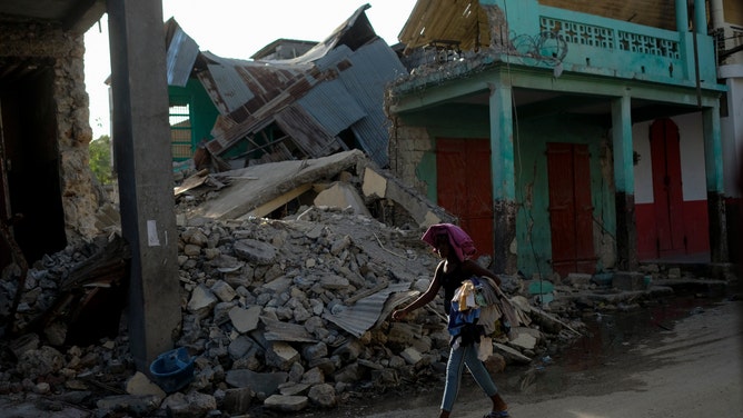
A woman walks past a collapsed building in Jeremie, Haiti, Wednesday, Aug. 18, 2021, four days after the city was struck by a 7.2-magnitude earthquake. (AP Photo/Matias Delacroix)
The 7.2 magnitude earthquake that struck southern Haiti on Aug. 15, 2021, was a devastating blow to the already-struggling Caribbean country.
For instance, Haiti was still reeling from an earthquake in January 2010, the largest earthquake in that area of the country in over 240 years.
A confluence of factors, particularly the country’s geography, are why Haiti experiences exceptional destruction from these seismic events.
Prisoners of geography and geology
Haiti is vulnerable to earthquakes because it sits at the intersection of three tectonic plates.
Tectonic plates are large, slow-moving segments of the Earth’s crust that may move away, toward or slide next to each other. This movement where the plates meet, called faults, can snag on each other and build up pressure over time. At a certain point, that pressure causes the snag to suddenly slip and let go, thereby releasing a tremendous amount of energy.
That release of energy is an earthquake.
The plate where the majority of Haiti rests is called the Gonave Microplate. To its north is the North American Plate and to its south, where part of the Haitian peninsula rests, is the Caribbean Plate. The Caribbean Plate largely moves eastward while the North American Plate largely moves westward, leaving the Gonave Microplate — and thusly, much of Haiti — at the center, surrounded by fault lines where pressure from these movements builds up.
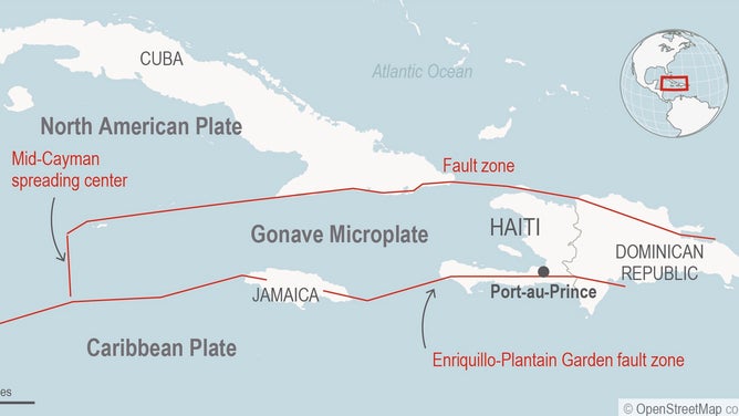
(U.S. Geological Survey / Associated Press)
Epicenter stage
Earthquakes are sometimes followed by another natural disaster: tsunamis. However, the occurrence of a tsunami depends on the location of an earthquake’s epicenter.
According to the United States Geological Survey (USGS), tsunamis are caused by earthquakes with epicenters on the seafloor and at a shallow depth.
The epicenter of Haiti’s Aug. 15 earthquake was located on land, along the fault line between the Gonave Microplate and the Caribbean Plate. Because the earthquake’s epicenter was above water, the chances of Haiti experiencing a tsunami were slim.
One example of a tsunami caused by an underwater earthquake occurred in Southeast Asia the day after Christmas in 2004. An earthquake off the coast of Sumatra, an island in Indonesia, struck at a magnitude of 9.1 — a magnitude that tied it as the third-largest earthquake in history.
Its immense power created a series of tsunamis across the Indian Ocean, with some ocean waves as tall as 30 feet or more by the time they reached land.
26th Dec 2004: #tsunami with the epicentre off the west coast of #Sumatra in the Indian Ocean killed 230,000–280,000 people in 14 #countries pic.twitter.com/jjJwiJeifR
— Gautam Purohit (@gautam4news) December 25, 2016
Russian roulette with the planet
According to the National Oceanic and Atmospheric Association (NOAA), between 15 and 20 tectonic plates make up the Earth’s crust. That means, between each of those plates, there are thousands of miles’ worth of fault lines with the potential of creating earthquakes.
By knowing where those faults lie, their activity and type of movement, communities living nearby can try to implement emergency preparedness measures to help ensure safety and mitigate the loss of life.