Satellite imagery shows extensive flooding in Brazil as death toll reaches 100
Meteorologists with Brazil's NIM said El Niño is partially to blame for the wet weather pattern, as the warming waters of the Pacific Ocean help block cold fronts and concentrate areas of instability over the Rio Grande do Sul area.
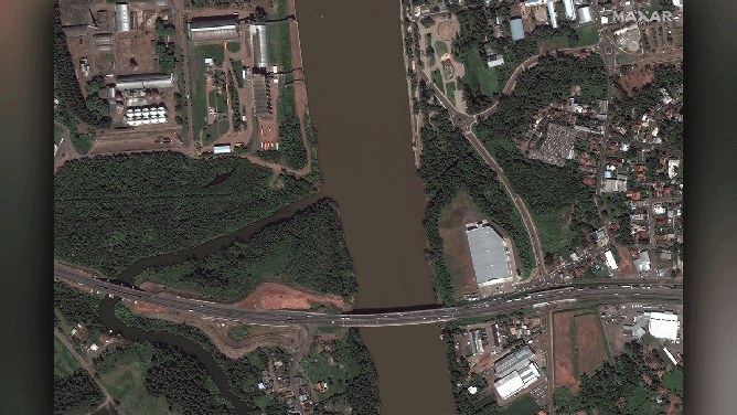
Maxar has collected recent satellite imagery that reveals extensive flooding in progress across the Rio Grande do Sul region of southern Brazil.
(Satellite image ©2024 Maxar Technologies)
ELDORADO DO SUL, Brazil – Recent floods in the Rio Grande do Sul region of southern Brazil have caused catastrophic damage and loss of life.
Many cities and towns are still submerged, and critical infrastructure like airports, railways and roads remain underwater or affected by the floods in the region.
Since the unprecedented deluge started last week, at least 100 people have been confirmed dead, with an additional 4 deaths currently under investigation. The situation has been made worse by the dozens still missing, hundreds injured and over 150,000 left homeless.
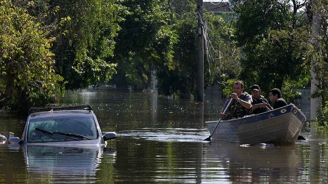
Locals move in boats following floodings due to heavy rains in Porto Alegre, Rio Grande do Sul state, Brazil on May 6, 2024.
(NELSON ALMEIDA/AFP / Getty Images)
Maxar Technologies has collected recent satellite imagery that reveals extensive flooding in the cities of Estrela, Lajeado, Porto Alegre, Tauquari and Montenegro.
Before/after views of flooding in Porto Alegre, Brazil.
(Satellite image ©2024 Maxar Technologies)
Brazilian authorities have launched a massive relief operation to help those affected by the floods, but the situation remains incredibly challenging.
"We've been without food for three days and we've only just got this blanket. I'm with people I don't even know, I don't know where my family is," said a young man to Reuters, who gave his name as Ricardo Junior.
WHAT DOES THE TERM '100-YEAR FLOOD' ACTUALLY MEAN?
Before/after views of flooding in Porto Alegre, Brazil.
(Satellite image ©2024 Maxar Technologies / FOX Weather)
The storms that hit the region in late April were particularly severe. They brought with them over 20 inches of rainfall, which caused extensive damage to homes and infrastructure. About 20% of the region remains without water service and nearly a million are without power. The rain is expected to ease up on Thursday. However, it is likely to continue throughout the upcoming weekend.
Meteorologists with Brazil's NIM said El Niño is partially to blame for the wet weather pattern, as the warming waters of the Pacific Ocean help block cold fronts and concentrate areas of instability over the Rio Grande do Sul area.