Volcanic gas forces renewed evacuations in Grindavik amid ongoing fears of eruption in Iceland
There are no indications that an eruption occurring, but “gas doesn’t appear unless magma is very high in the earth’s crust."
Grindavik evacuated again after increased levels of sulfur dioxide detected
Residents who were allowed to return to Grindavik in Iceland on Tuesday were told to evacuate after meters detected an increase in levels of sulfur dioxide in the area.
GRINDAVIK, Iceland – Residents who were allowed to briefly return to Grindavík on Tuesday were evacuated again after sensors detected an increase in sulfur dioxide gas – a sign of potential encroaching volcanic activity as the region remains on alert for a possible eruption in southwestern Iceland.
According to national public service broadcaster RÚV, the Professional Manager at the Icelandic Meteorological Office (IMO) said new gas meters recently installed in Grindavík reported high levels of sulfur dioxide, and he informed the police, who then decided to evacuate the town.
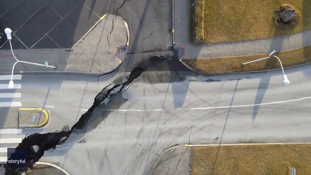
DRONE VIDEO SHOWS LARGE CRACK SPLITTING ICELANDIC TOWN'S STREET AMID VOLCANIC THREAT
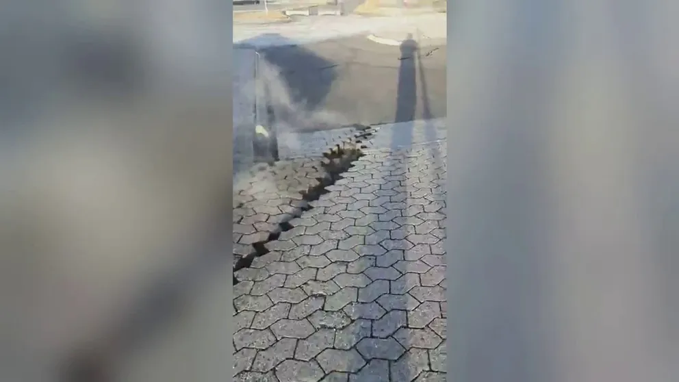
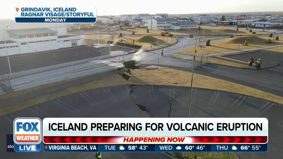
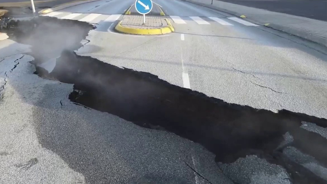
Watch: Video shows steam rising from cracked roads in Grindavik amid Iceland volcanic eruption fears
Video recorded in Grindavik shows steam coming from cracks that formed in roads. The seaside town in Iceland is preparing for a possible volcanic eruption.
RÚV reports that there are no indications that an eruption is occurring, but "gas doesn’t appear unless magma is very high in the earth’s crust."
The town was not in an emergency evacuation, RÚV reported, and instead, people were led to safety "in an orderly manner." According to RÚV, 90 people were in Grindavík when the new evacuation was ordered and it only took 95 seconds to get everyone to safety.
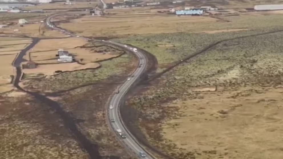
Watch: Cars flee Grindavik amid fears of volcanic eruption in Iceland
Video from the Icelandic Coast Guard shows cars leaving the seaside town of Grindavik amid fears that a volcano there could erupt at any time.
Situation remains dangerous in Iceland
Iceland’s Department of Civil Protection and Emergency Management said in Facebook posts that the situation in the Grindavik area remains dangerous, and large cracks, as well as fire breaks, could form at any time.
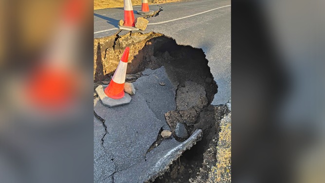
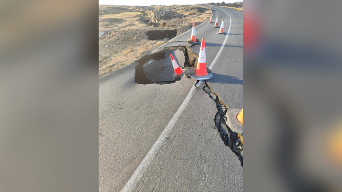
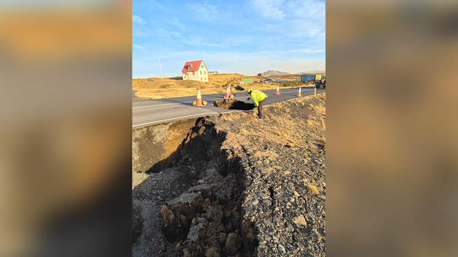
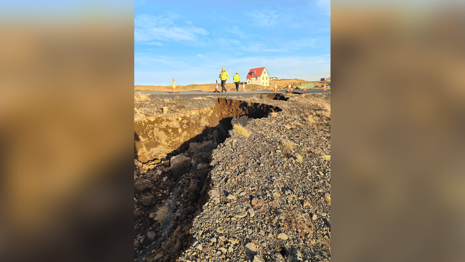
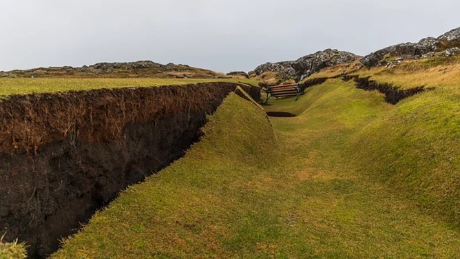
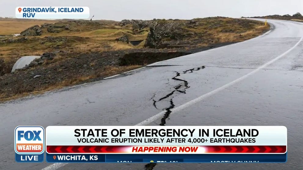
Video and photos from the area show large cracks that have already formed across roads in and around Grindavik.
ICELAND RESIDENT DESCRIBED RELENTLESS EARTHQUAKES, MOMENTS OF PANICKED EVACUATION
Watch: Drone video shows large crack in Iceland town threatened by volcanic activity
Video from Grindavik, Iceland, show large cracks that have formed amid thousands of earthquakes reported in the region. There are fears that a volcano could erupt there soon.
The Icelandic Meteorological Office (IMO) said on its website Tuesday that about 700 earthquakes have been reported in the region since midnight, with the largest a magnitude 3.1 at Hagafell. A magnitude 3.8 was recorded at Kleifarvatn late Monday night.
The IMO said most of the earthquake activity has been reported along the magma tunnel at a depth of about 1.86 miles to 3.1 miles.
Data shows that land deformation continues in the area – more than 3 feet in some spots – which is consistent with magma still flowing beneath the earth’s surface.
WHAT HAPPENS BEFORE A VOLCANO ERUPTS?
![GRINDAVIK, ICELAND - NOVEMBER 13: Residents were allowed to enter Grindivik for a few hours to retrieve belongings on November 13, 2023 in Grindavik, Iceland. Iceland has declared a state of emergency after a series of earthquakes with authorities ordering thousands of people to leave the southwestern town of Grindavík as a precaution. The Icelandic Meteorological Office (IMO) has said there was a considerable risk of a volcanic eruption. (Photo by Micah Garen/Getty Images)]() Image 1 of 23
Image 1 of 23GRINDAVIK, ICELAND - NOVEMBER 13: Residents were allowed to enter Grindivik for a few hours to retrieve belongings on November 13, 2023 in Grindavik, Iceland. Iceland has declared a state of emergency after a series of earthquakes with authorities ordering thousands of people to leave the southwestern town of Grindavík as a precaution. The Icelandic Meteorological Office (IMO) has said there was a considerable risk of a volcanic eruption. (Photo by Micah Garen/Getty Images) ( )
![A large crack is seen cutting across a road in Grindavik, Iceland, amid fears that a volcano could erupt at any time.]() Image 2 of 23
Image 2 of 23A large crack is seen cutting across a road in Grindavik, Iceland, amid fears that a volcano could erupt at any time. (Ragnar Visage via Storyful)
![Footage filmed by Ragnar Visage shows steam rising from a crack in the street and a nearby parking lot at the intersection of Austervegur and Stamphólsvegur streets in Grindavik.]() Image 3 of 23
Image 3 of 23Footage filmed by Ragnar Visage shows steam rising from a crack in the street and a nearby parking lot at the intersection of Austervegur and Stamphólsvegur streets in Grindavik. (Ragnar Visage via Storyful)
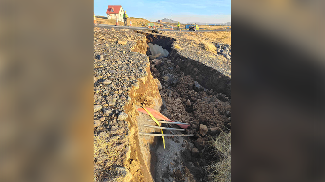
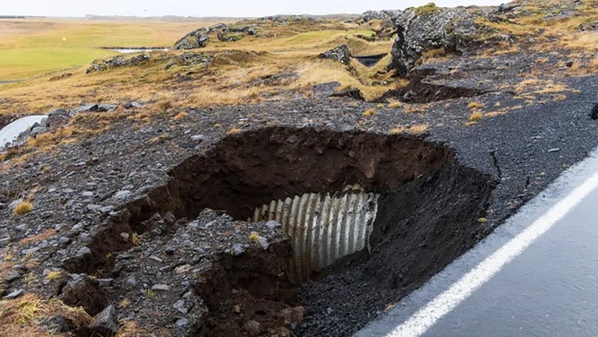
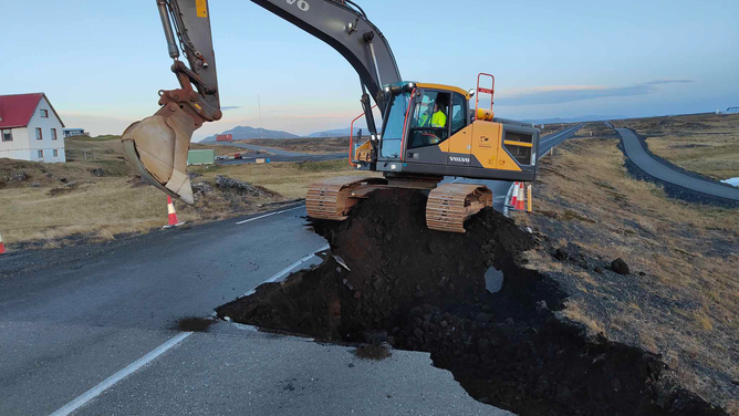
![A large hole is seen in a road near Grindavik in Iceland amid fears of a volcanic eruption.]() Image 4 of 23
Image 4 of 23A large hole is seen in a road near Grindavik in Iceland amid fears of a volcanic eruption. (Facebook.com/Vegagerdin)
![A large crack and hole is seen in a road near Grindavik in Iceland amid fears of a volcanic eruption.]() Image 5 of 23
Image 5 of 23A large crack and hole is seen in a road near Grindavik in Iceland amid fears of a volcanic eruption. (Facebook.com/Vegagerdin)
![Crews are seen inspecting a road outside of Grindavik in Iceland amid fears of a volcanic eruption.]() Image 6 of 23
Image 6 of 23Crews are seen inspecting a road outside of Grindavik in Iceland amid fears of a volcanic eruption. (Facebook.com/Vegagerdin)
![Crews are seen inspecting a road outside of Grindavik in Iceland amid fears of a volcanic eruption.]() Image 7 of 23
Image 7 of 23Crews are seen inspecting a road outside of Grindavik in Iceland amid fears of a volcanic eruption. (Facebook.com/Vegagerdin)
![A large crack developed across a road outside Grindavik in Iceland amid fears of a volcanic eruption.]() Image 8 of 23
Image 8 of 23A large crack developed across a road outside Grindavik in Iceland amid fears of a volcanic eruption. (Facebook.com/Vegagerdin)
![A large crack developed across a road outside Grindavik in Iceland amid fears of a volcanic eruption.]() Image 9 of 23
Image 9 of 23A large crack developed across a road outside Grindavik in Iceland amid fears of a volcanic eruption. (Facebook.com/Vegagerdin)
![Crews inspect a road after a large crack appeared amid fears that a volcano will erupt there soon.]() Image 10 of 23
Image 10 of 23Crews inspect a road after a large crack appeared amid fears that a volcano will erupt there soon. (Facebook.com/Vegagerdin)
![GRINDAVIK, ICELAND - NOVEMBER 12: Children bring food to police and emergency workers outside Grindavik on November 12, 2023 in Grindavik, Iceland. Iceland has declared a state of emergency after a series of earthquakes with authorities ordering thousands of people to leave the southwestern town of Grindavík as a precaution.The Icelandic Meteorological Office (IMO) has said there was a considerable risk of a volcanic eruption. (Photo by Micah Garen/Getty Images)]() Image 11 of 23
Image 11 of 23GRINDAVIK, ICELAND - NOVEMBER 12: Children bring food to police and emergency workers outside Grindavik on November 12, 2023 in Grindavik, Iceland. Iceland has declared a state of emergency after a series of earthquakes with authorities ordering thousands of people to leave the southwestern town of Grindavík as a precaution.The Icelandic Meteorological Office (IMO) has said there was a considerable risk of a volcanic eruption. (Photo by Micah Garen/Getty Images) ( )
![GRINDAVIK, ICELAND - NOVEMBER 12: Emergency workers outside Grindavik on November 12, 2023 in Grindavik, Iceland. Iceland has declared a state of emergency after a series of earthquakes with authorities ordering thousands of people to leave the southwestern town of Grindavík as a precaution.The Icelandic Meteorological Office (IMO) has said there was a considerable risk of a volcanic eruption. (Photo by Micah Garen/Getty Images)]() Image 12 of 23
Image 12 of 23GRINDAVIK, ICELAND - NOVEMBER 12: Emergency workers outside Grindavik on November 12, 2023 in Grindavik, Iceland. Iceland has declared a state of emergency after a series of earthquakes with authorities ordering thousands of people to leave the southwestern town of Grindavík as a precaution.The Icelandic Meteorological Office (IMO) has said there was a considerable risk of a volcanic eruption. (Photo by Micah Garen/Getty Images) ( )
![GRINDAVIK, ICELAND - NOVEMBER 12: Hanna Evensen from Cat Shelter waited over five hours at a check point to rescue some of the 59 cats left in Grindavik, but was refused entry by the police on November 12, 2023 in Grindavik, Iceland. Iceland has declared a state of emergency after a series of earthquakes with authorities ordering thousands of people to leave the southwestern town of Grindavík as a precaution.The Icelandic Meteorological Office (IMO) has said there was a considerable risk of a volcanic eruption. (Photo by Micah Garen/Getty Images)]() Image 13 of 23
Image 13 of 23GRINDAVIK, ICELAND - NOVEMBER 12: Hanna Evensen from Cat Shelter waited over five hours at a check point to rescue some of the 59 cats left in Grindavik, but was refused entry by the police on November 12, 2023 in Grindavik, Iceland. Iceland has declared a state of emergency after a series of earthquakes with authorities ordering thousands of people to leave the southwestern town of Grindavík as a precaution.The Icelandic Meteorological Office (IMO) has said there was a considerable risk of a volcanic eruption. (Photo by Micah Garen/Getty Images) ( )
![GRINDAVIK, ICELAND - NOVEMBER 12: Emergency workers outside Grindavik on November 12, 2023 in Grindavik, Iceland. Iceland has declared a state of emergency after a series of earthquakes with authorities ordering thousands of people to leave the southwestern town of Grindavík as a precaution.The Icelandic Meteorological Office (IMO) has said there was a considerable risk of a volcanic eruption. (Photo by Micah Garen/Getty Images)]() Image 14 of 23
Image 14 of 23GRINDAVIK, ICELAND - NOVEMBER 12: Emergency workers outside Grindavik on November 12, 2023 in Grindavik, Iceland. Iceland has declared a state of emergency after a series of earthquakes with authorities ordering thousands of people to leave the southwestern town of Grindavík as a precaution.The Icelandic Meteorological Office (IMO) has said there was a considerable risk of a volcanic eruption. (Photo by Micah Garen/Getty Images) ( )
![GRINDAVIK, ICELAND - NOVEMBER 12: The road to Grindavik is closed by the police on November 12, 2023 in Grindavik, Iceland. The country has declared a state of emergency after a series of earthquakes around the Fagradalsfjall volcano in recent weeks, prompting worries of a potential eruption. (Photo by Micah Garen/Getty Images)]() Image 15 of 23
Image 15 of 23GRINDAVIK, ICELAND - NOVEMBER 12: The road to Grindavik is closed by the police on November 12, 2023 in Grindavik, Iceland. The country has declared a state of emergency after a series of earthquakes around the Fagradalsfjall volcano in recent weeks, prompting worries of a potential eruption. (Photo by Micah Garen/Getty Images) ( )
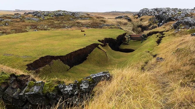
![The golf course in Grindavík is experiencing significant cracking from earthquakes.]() Image 16 of 23
Image 16 of 23The golf course in Grindavík is experiencing significant cracking from earthquakes. (RÚV)
![The golf course in Grindavík is experiencing significant cracking from earthquakes.]() Image 17 of 23
Image 17 of 23The golf course in Grindavík is experiencing significant cracking from earthquakes. (RÚV)
![The golf course in Grindavík is experiencing significant cracking from earthquakes.]() Image 18 of 23
Image 18 of 23The golf course in Grindavík is experiencing significant cracking from earthquakes. (RÚV)
![The golf course in Grindavík is experiencing significant cracking from earthquakes.]() Image 19 of 23
Image 19 of 23The golf course in Grindavík is experiencing significant cracking from earthquakes. (RÚV)
![The golf course in Grindavík is experiencing significant cracking from earthquakes.]() Image 20 of 23
Image 20 of 23The golf course in Grindavík is experiencing significant cracking from earthquakes. (RÚV)
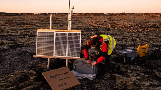
![Numerous seismographs have been installed by a team of geologists from the University of Iceland.]() Image 21 of 23
Image 21 of 23Numerous seismographs have been installed by a team of geologists from the University of Iceland. (Raul Moreno/SOPA Images/LightRocket)
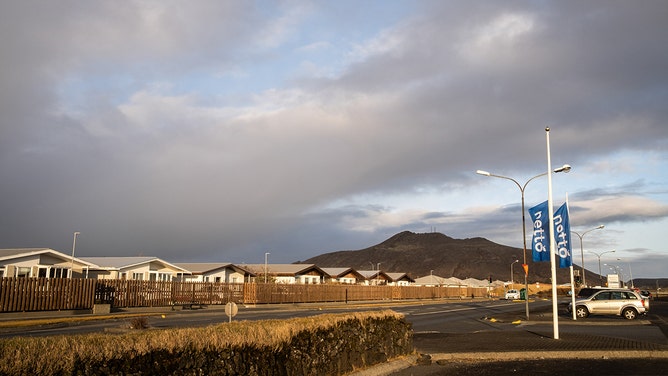
![A city street of Grindavik with Thorbjöm mountain in the background. Iceland is preparing for another volcanic eruption on the Reykjanes peninsula.]() Image 22 of 23
Image 22 of 23A city street of Grindavik with Thorbjöm mountain in the background. Iceland is preparing for another volcanic eruption on the Reykjanes peninsula. (Raul Moreno/SOPA Images/LightRocket)
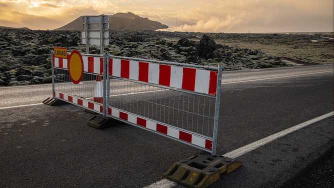
![The access road to Blue Lagoon has been closed to avoid incidents in the area in the event of a possible volcanic eruption.]() Image 23 of 23
Image 23 of 23The access road to Blue Lagoon has been closed to avoid incidents in the area in the event of a possible volcanic eruption. (Raul Moreno/SOPA Images/LightRocket)


The IMO said that between Nov. 12-13, magma flow was measured at about 75 cubic meters per second and the depth was about a half-mile.
However, the IMO said those numbers were based on calculations and some uncertainty remains.
Several roads in and around Grindavik, Iceland, have been damaged due to large cracks that have formed.
(Facebook.com/Vegagerdin)
"The probability of an eruption is therefore still high," the IMO said. "In the event of an eruption, the most likely location is at the magma tunnel. There is no evidence otherwise in the data."
New data also suggests that if the volcano does erupt in the Grindavík area, it is no longer thought to be explosive – which is good news for international air travel as toxic ash and smoke won’t be released as high into the atmosphere.
CAN ONE VOLCANO'S ERUPTION TRIGGER AN ERUPTION AT ANOTHER VOLCANO?
Defense walls being built to protect infrastructure
'Impossible To Be In': Iceland resident details evacuating home during earthquakes
Iceland resident Hans Vera had to evacuate from his home in Grindavik on Friday night. He is now staying with family in Reykjavík, as seismic and volcanic activity continues in Iceland.
RÚV reports crews have been gathering material from gravel quarries since Friday in preparation for the construction of defense walls that will surround important infrastructure to protect against threats of a likely volcanic eruption like lava flows.
Plans were approved overnight, and construction of defense walls surrounding the geothermal power plant in Svartsengi is expected to begin on Tuesday.
The excess water from the Svartsengi power plant is used to fill the popular tourist destination Blue Lagoon, which shut down operations on Nov. 9 due to fears of a volcanic eruption in the area.