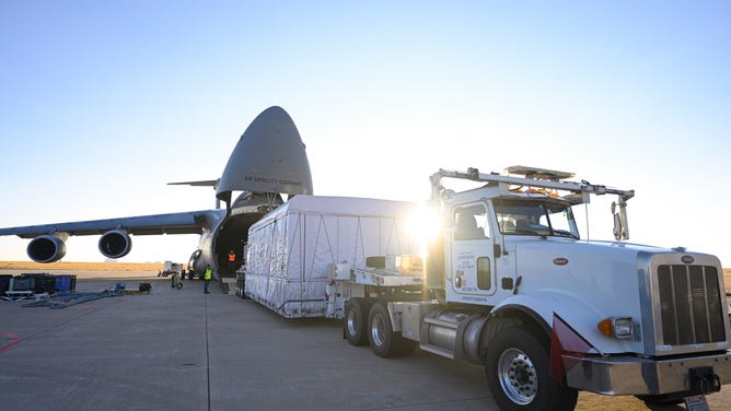
GOES-T satellite arrives at Kennedy Space Center in preparation for launch
The GOES-T satellite arrived at Kennedy Space Center on Wednesday.
GOES-T Ships from Colorado to Florida
The Geostationary Operation Environmental Satellite, GOES-T, arrived at Kennedy Space Center after leaving Colorado Tuesday.
The next weather satellite that will help forecasters has successfully made it to Florida to begin launch preparations.
On Wednesday, the Geostationary Operation Environmental Satellite, GOES-T, arrived at Kennedy Space Center after leaving Colorado Tuesday.
GOES-T is the third of four satellites in NOAA's GOES-R weather satellite series built by Lockheed Martin in Littleton, Colorado.
"The technology and instruments we've developed for the GOES-R series enable GOES-T to observe Earth and space weather faster and more accurately than ever," said Lockheed Martin GOES-R chief engineer Jagdeep Shergill. "Lockheed Martin has built more than 100 weather and environmental observation spacecraft throughout our history, and we couldn't be more excited to add GOES-T to that lineup as we use continue to evolve the technology toward the future with each system we build."
Because of the large size of the satellite, it was flown to Florida in the Lockheed Martin-built C-5M Super Galaxy aircraft.
GOES-T Shipment to Buckley Space Force Base
The Lockheed Martin Space team says that to protect GOES-T's sensitive, state-of-the-art instruments, they enclosed the spacecraft in a shipping container that functioned as its miniature cleanroom environment.
While at Kennedy Space Center, teams will prepare for the GOES-T launch, scheduled for February 16, 2022.
![]() Image 1 of 18
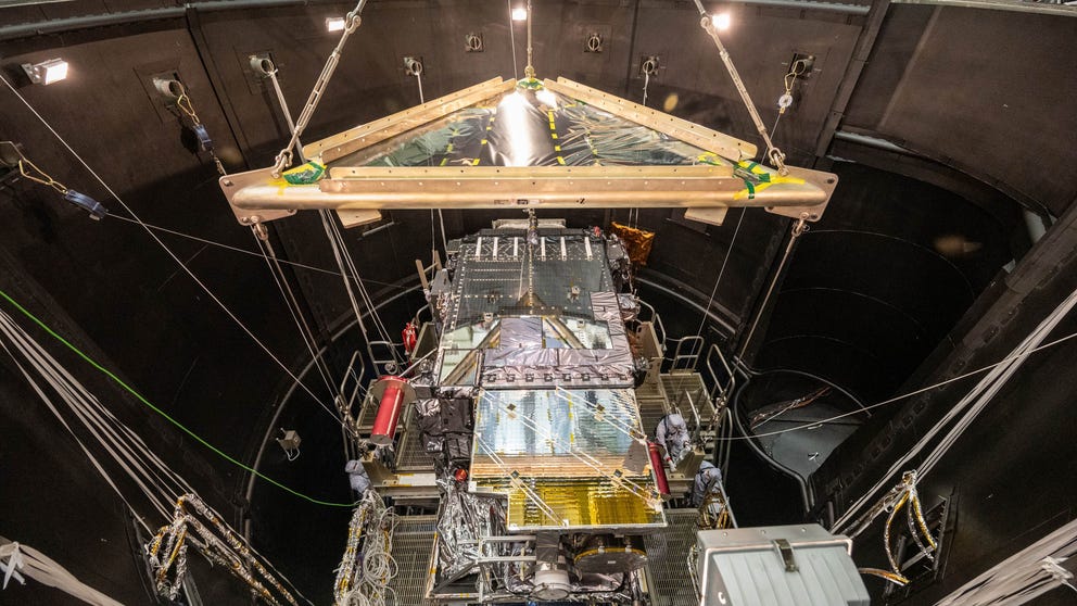
Image 1 of 1820-11723 GOES-T lift to Thermal Vacuum Chamber. (Lockheed Martin)
![]() Image 2 of 18
Image 2 of 18OLYMPUS DIGITAL CAMERA (Lockheed Martin)
![]() Image 3 of 18
Image 3 of 1820-11723 GOES-T lift to Thermal Vacuum Chamber. (Lockheed Martin)
![]() Image 4 of 18
Image 4 of 18(Lockheed Martin)
![]() Image 5 of 18
Image 5 of 1820-11723 GOES-T lift to Thermal Vacuum Chamber. (Lockheed Martin)
![]() Image 6 of 18
Image 6 of 1820-11723 GOES-T lift to Thermal Vacuum Chamber. (Lockheed Martin)
![]() Image 7 of 18
Image 7 of 1820-11723 GOES-T lift to Thermal Vacuum Chamber. (Lockheed Martin)
![]() Image 8 of 18
Image 8 of 1820-11723 GOES-T lift to Thermal Vacuum Chamber. (Lockheed Martin)
![]() Image 9 of 18
Image 9 of 1820-11723 GOES-T lift to Thermal Vacuum Chamber. (Lockheed Martin)
![]() Image 10 of 18
Image 10 of 1820-11723 GOES-T lift to Thermal Vacuum Chamber. (Lockheed Martin)
![]() Image 11 of 18
Image 11 of 1820-11723 GOES-T lift to Thermal Vacuum Chamber. (Lockheed Martin)
![]() Image 12 of 18
Image 12 of 1820-11723 GOES-T lift to Thermal Vacuum Chamber. (Lockheed Martin)
![]() Image 13 of 18
Image 13 of 1820-11723 GOES-T lift to Thermal Vacuum Chamber. (Lockheed Martin)
![]() Image 14 of 18
Image 14 of 1820-11723 GOES-T lift to Thermal Vacuum Chamber. (Lockheed Martin)
![]() Image 15 of 18
Image 15 of 18GOES-T Shipment to Buckley Space Force Base (Lockheed Martin)
![]() Image 16 of 18
Image 16 of 18GOES-T Shipment to Buckley Space Force Base (Lockheed Martin)
![]() Image 17 of 18
Image 17 of 18GOES-T Shipment to Buckley Space Force Base (Lockheed Martin)
![]() Image 18 of 18
Image 18 of 18GOES-T-Solar Array Deployment (Lockheed Martin)


About the mission
The GOES-R series includes four weather satellites: GOES-16, GOES-17, GOES-T and GOES-U.
GOES-16 and GOES-17 were known as GOES-R and GOES-S before entering orbit. GOES-U is in production for a 2024 launch.
This series is a joint effort between NOAA and NASA to develop, launch and operate weather satellites. NOAA manages GOES satellites, and NASA oversees the acquisition of the spacecraft and instruments.
Lockheed Martin said that this satellite would specifically help with:
- Mapping of tropical storms and hurricanes in the Pacific Ocean
- Producing real-time fire boundaries seen on Google Maps by tracking wildfire conditions and related weather
- Supporting NOAA's Search and Rescue Satellite-Aided Tracking (SARSAT) system, which has helped rescue thousands of people
- Generating total lightning data that can give early indications of a storm's strength, thanks to a first-of-its-kind lightning mapper built by Lockheed Martin
These weather satellites will help meteorologists better predict the weather by providing images and data to continue to help protect lives and property.