Cross-country winter storm could dump historic snow on Minneapolis similar to what collapsed Metrodome’s roof
A winter storm dumped 17.1 inches of snow in Minneapolis on Dec. 10-11, 2010. The powerful snowstorm that hit the area forced an NFL game between the New York Giants and the Minnesota Vikings to be postponed after the Metrodome's roof collapsed under the weight of heavy snow.
Inflatable Metrodome roof collapses in 2010 under weight of snow in Minneapolis
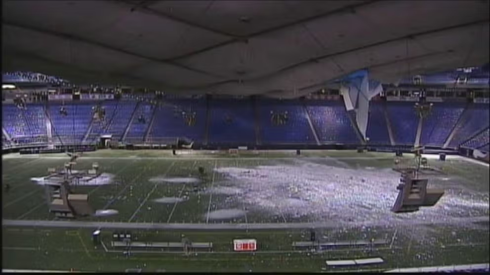
A FOX camera was rolling inside the Metrodome in Minneapolis, Minnesota, at 5 a.m. Dec. 12, 2010, when it caught a jaw dropping scene. At first just a trickle, then, an avalanche as 17 inches of snow and ice broke through the dome -- just seven hours before kickoff.
MINNEAPOLIS – A massive winter storm will likely provide the biggest snowfall for the Twin Cities since Brett Favre's last year of his career as a Minnesota Viking in 2010.
Minneapolis has been in the crosshairs of several storms already this winter. That's why it has seen more than 57 inches of snow so far, which is more than 20 inches above average by this point in the season.
Winter storm blankets Minneapolis in snow, skyline disappears
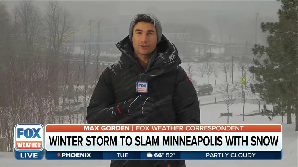
The Twin Cities braces for a very significant winter storm event this week. The Minneapolis skyline has already disappeared into whiteness Tuesday afternoon. FOX Weather correspondent Max Gorden spoke to residents about storm preparation with conditions likely deteriorating this evening.
And now a potentially "historic" winter storm is on the way, noted the National Weather Service office in the Twin Cities.

(FOX Weather)
As this week's coast-to-coast storm slams the northern Plains and Upper Midwest, it could deliver prolific snow totals for Minneapolis-St. Paul, jeopardizing decades-old snowstorm records.
MASSIVE COAST-TO-COAST WINTER STORM TO PUMMEL MILLIONS WITH BLIZZARD CONDITIONS, SIGNIFICANT ICING
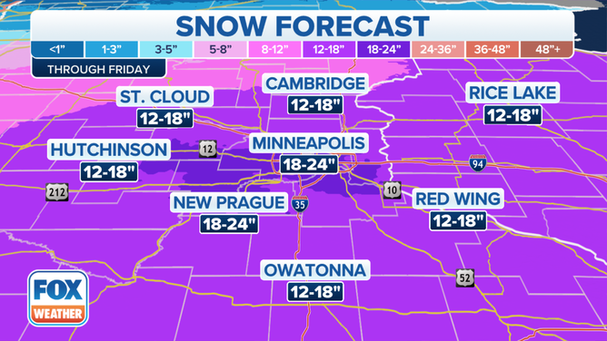
Between 1 and 2 feet of snow is likely to fall across parts of the northern Plains and Upper Midwest, with blizzard conditions possible.
(FOX Weather)
The FOX Forecast Center said a foot or more of snow is expected across portions of the northern Plains, Upper Midwest and northern Great Lakes. The Twin Cities are in the bull's-eye for 18 to 24 inches of snow, which would be the heaviest snowstorm in at least a dozen years for Minneapolis-St. Paul.
Blowing snow in Minnesota likely will make traveling 'very hazardous'
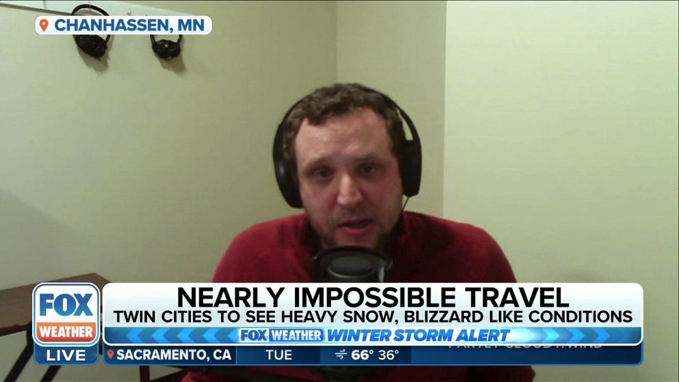
NWS Twin Cities Meteorologist Ryan Dunleavy told FOX Weather central and southern Minnesota can expect blizzard conditions and close to 2 feet of snow from a powerful winter storm. Dunleavy urges residents to avoid roadways during blowing snow.
What was the ‘Domebuster of 2010'?
The storm could exceed what the NWS called the "Domebuster of 2010," when the Hubert H. Humphrey Metrodome roof collapsed under the weight of 17.1 inches of heavy snow on Dec. 12, 2010.

This photo composite shows Hubert H. Humphrey Metrodome, Mall of America Stadium before (above) and after its inflatable roof collapsed under the weight of snow and during a storm on Dec. 12, 2010, in Minneapolis.
(Doug Pensinger (above), Tom Dahlin (below) / Getty Images)
The powerful winter storm hit the area on Dec. 10-11, 2010, and forced an NFL game between the New York Giants and the Minnesota Vikings to be postponed after the Metrodome's roof collapsed. The game was relocated to Detroit's Ford Field. There were no injuries reported from the collapse of the dome.
That storm was the fifth-largest snowstorm on record for the Twin Cities since recordkeeping began 1884.
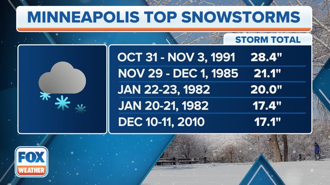
This could be one of the top snowstorms on record for Minneapolis.
(FOX Weather)
Heavy snow with visibilities of a quarter-mile or less were reported at the Twin Cities Airport for eight hours straight from 9 a.m. to 4 p.m. on Dec. 11, the Minnesota Department of Natural Resources (DNR) said. The Minneapolis-St. Paul International Airport was closed for four hours as Blizzard Warnings were posted for all of southern Minnesota.
Cities around the metro struggled for days to remove the snow from streets and sidewalks, according to the DNR. School were also canceled for two days for St. Paul and Minneapolis.
It was not the first structural failure for the dome. Before construction was even completed on Metrodome, a foot of snow deflated the dome back in 1981. It happened again, twice, in the following two years.
WHAT MAKES A BLIZZARD DIFFERENT FROM AN ORDINARY SNOWSTORM?
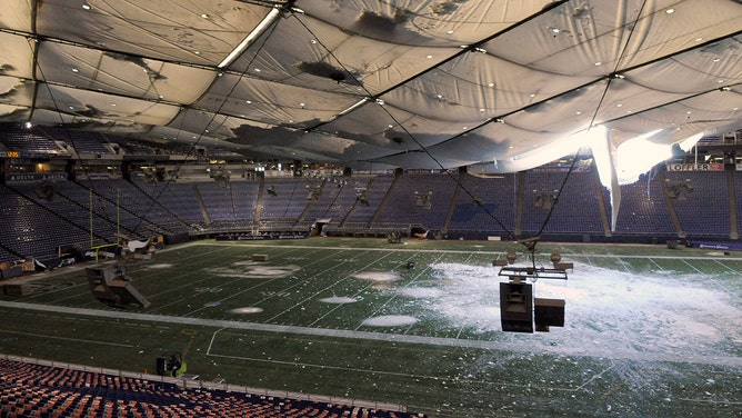
A torn section of the roof sags inside the Hubert H. Humphrey Metrodome on December 13, 2010 in Minneapolis, Minnesota.
(Hannah Foslien / Getty Images)
‘A top-five snowstorm for Minneapolis’
As for this week's storm in southern Minnesota, the first round of snow moves in Tuesday afternoon and lasts into Tuesday night, the FOX Forecast Center said. There will be a slight lull in action before the next round moves in Wednesday night and lasts into late Thursday. This is when the heaviest snow will fall.
"A top-five snowstorm for Minneapolis … this one is going to not only produce a lot of snow, but unfortunately we're going to have the strong winds associated with this too," FOX Weather winter storm specialist Tom Niziol said.
Major travel disruptions are likely, whether traveling by the roads or the skies. Multiple school and road closures are expected. At the peak of the cross-country winter storm, the continuous coverage of the snow, ice and rain could exceed 2,000 miles from west to east.
"The track of this system looks like it's perfect for the Minneapolis area," Niziol added. "Blizzard conditions, not only because of the low-pressure system, but that strong arctic high to the north. It's the pressure difference that produces strong winds. And that's what we're seeing in this classic setup."
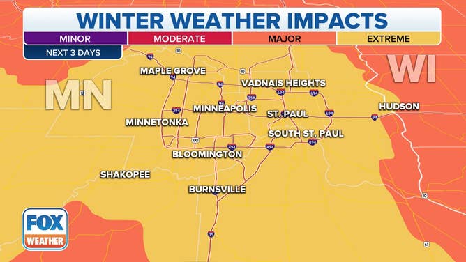
Over the next three days, "extreme" impacts – the highest category in the Winter Storm Severity Index – from this coast-to-coast winter storm are expected across south-central Minnesota, including the Minneapolis-St. Paul metro area.
(FOX Weather)