Bryan Norcross: Tropical Storm Ophelia moves inland in North Carolina spreading wind and rain far to the north
Well out in the tropical Atlantic, a new tropical depression or tropical storm is about to form. It will eventually get the name Philippe. The system is forecast to track in the general direction of the Caribbean islands for the next few days.

FOX Weather is your Hurricane HQ, streaming free 24/7.
(FOX Weather / FOX Weather)
The center of Tropical Storm Ophelia’s circulation made landfall this morning near Morehead City in eastern North Carolina. The strongest winds are blowing off the ocean from North Carolina to New Jersey. Rain will spread across the Northeast into New England today as Ophelia impacts the northern half of the eastern seaboard.
The system that became Ophelia developed off the Florida coast out of a combination of a front and an upper-air disturbance. Initially, the wind and rain were caused by the front and the air being squeezed between the system’s developing low pressure and a strong high-pressure system to the north. As budding-Ophelia tracked over the very warm Gulf Stream waters yesterday, it also developed a tropical-storm core.
This dual structure continues. The winds and rain affecting the coastal sections from North Carolina to about Delaware are most directly related to the core of the storm. The rain spreading through the Northeast into New England is the legacy of the front well to the north of the center of circulation.
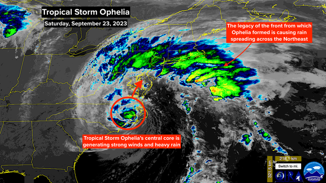
Tropical Storm Ophelia. Sept. 23, 2023.
(CIRA / RAAMB / FOX Weather)
The top winds in the storm will slowly continue to slowly decrease today, but its forward motion will slow down as well. Although the tropical system is expected to die out tomorrow night plus or minus, the remnants of the system and the strong upper-air disturbance that started it will linger into next week, so the Mid-Atlantic and Northeast will be slow to clear.
This won’t be a continuous dumping of rain. Dry air has wrapped into the gap between the frontal legacy to the north and the slowly weakening central core that will track over eastern Virginia. So some areas will get a break between the bands of rain.
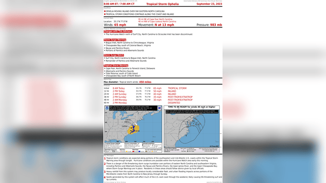
Tropical Storm Ophelia Advisory Summary. Sept. 23, 2023.
(NWS / NOAA)
The continuous easterly winds have been pushing ocean water against the East Coast for two days, and that will continue until the storm passes and the wind shifts. Storm surge will continue to affect rivers, bays, and harbors where the water can pile up. Stay aware of storm surge alerts issued for individual rivers, bays, and sounds from North Carolina to New Jersey. High tides will be several feet above normal in some areas.
Tornados are also possible in the rain bands ahead of the center of circulation.
Up to 8 inches of rain is forecast for the affected parts of North Carolina and Virginia. With lesser amounts but still heavy rain across the Mid-Atlantic and Northeast until this is over early next week.
Stay aware.
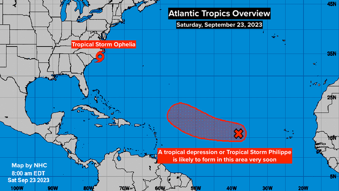
Atlantic Tropics Overview. Sept. 23, 2023.
(National Hurricane Center / NOAA)
Well out in the tropical Atlantic, a new tropical depression or tropical storm is about to form. It will eventually get the name Philippe. The system is forecast to track in the general direction of the Caribbean islands for the next few days. But the dip in the jet stream that will eventually move what’s left of Ophelia away from the U.S. is expected to also pull likely-Philippe to the north before it gets to the islands.
We’ll want to watch to be sure it turns, but the long-range forecasts have come into good agreement.
Another disturbance is about to come off Africa and proceed to the west over the tropical Atlantic. There are no signs of it being a problem at the current time.
As we approach the end of September, we’ll start looking to the western Caribbean for tropical development. These strong dips in the jet stream, like the one that initiated the system that became Ophelia, are concerning because they can pull systems north into the Gulf later in the year. There’s no sign of that happening at this point, but it’s where we’ll watch.