Tropical Storm Dalila causes flooding, mudslides along Mexican coast as system slowly departs
The National Hurricane Center is also watching another tropical disturbance for possible development in the Eastern Pacific offshore of southeastern Mexico and Central America. FOX Weather Hurricane Specialist Bryan Norcross said this system, dubbed Invest 94E, could possibly have implications for Acapulco, Mexico.

Tropical Storm Dalila to weaken after causing mudslides, flooding in Mexico
Tropical Storm Dalila reached it peak intensity and is now expected to weaken after the storm caused flooding and mudslides in Mexico. FOX Weather Meteorologists Jane Minar and Ari Sarsalari break down the forecast on June 15, 2025.
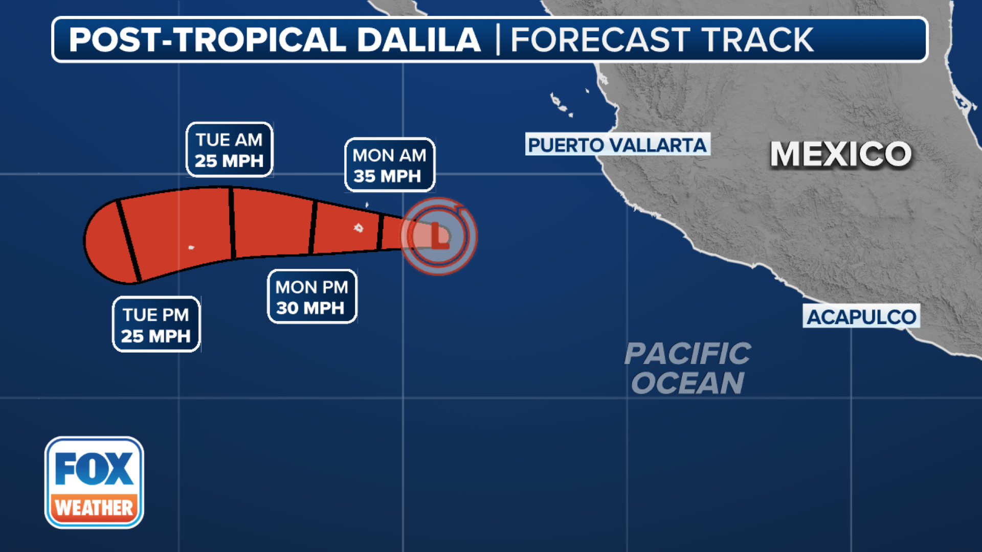
Tropical Storm Dalila reached its peak intensity on Saturday and began to weaken Sunday morning after brushing the Mexican coastline with heavy rainfall, rough surf and gusty winds south of Manzanillo.
The National Hurricane Center (NHC) last reported that Dalila had maximum sustained winds of around 45 mph with higher gusts, and steady weakening is forecast over the next few days as both ocean temperatures and atmospheric conditions become less favorable for tropical cyclones.
Dalila is expected to become a post-tropical remnant low on Sunday night or early Monday.

(FOX Weather)
A tropical storm is a tropical cyclone that has maximum sustained winds 39 and 73 mph – a step above a tropical depression.
Additional rainfall amounts of 1-2 inches are possible across portions of the Mexican states of Nayarit, Jalisco, Colima and Michoacán on Sunday, with locally higher amounts of up to 9 inches near the coast.
The NHC said that any instances of flash flooding and mudslides should decrease by later Sunday.
HOW ARE HURRICANES RATED? THE SAFFIR-SIMPSON HURRICANE WIND SCALE EXPLAINED
(FOX Weather)
Dalila also generated life-threatening surf and rip current conditions for many beaches along the country's Pacific coast.
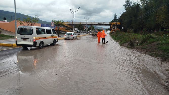
In Acapulco, mudslides and flooding were reported over the weekend.
Photos from the Secretariat of Comprehensive Risk Management and Civil Protection showed workers trudging through floodwaters.
Another photo from the department showed a tree that had fallen onto a home in Acapulco.
![Workers in Acapulco try and clear mud and debris amid flooding produced by Tropical Storm Dalila.]() Image 1 of 3
Image 1 of 3Workers in Acapulco try and clear mud and debris amid flooding produced by Tropical Storm Dalila. (Secretariat of Comprehensive Risk Management and Civil Protection)
![Crews walk through flooding in Acapulco, Mexico.]() Image 2 of 3
Image 2 of 3Crews walk through flooding in Acapulco, Mexico. (Secretariat of Comprehensive Risk Management and Civil Protection)
![Tree fell onto van during storms produced by Tropical Storm Dalia in Acapulco, Mexico.]() Image 3 of 3
Image 3 of 3Tree fell onto van during storms produced by Tropical Storm Dalia in Acapulco, Mexico. (@SGIRPC_CDMX/ X )


Invest 94E could develop into tropical depression by midweek Eastern Pacific
The NHC is also watching another tropical disturbance for possible development in the Eastern Pacific offshore of southeastern Mexico and Central America.
Designated as Invest 94E on Saturday, the disturbance has a high chance of developing over the next week.
An "invest" designation signals an area of heightened interest and allows the NHC to run a collection of specialized datasets and computer forecast model guidance on that area of disturbed weather. These computer models simulate the system’s projected track possibilities and predict its future intensity.
"Environmental conditions are expected to be conducive for gradual development of this system, and a tropical depression is likely to form by the middle of this week while moving westward to west-northwestward just offshore of the coasts of El Salvador, Guatemala and southeastern Mexico," the NHC said on Sunday afternoon.

(FOX Weather)
FOX Weather Hurricane Specialist Bryan Norcross said Invest 94E could possibly have implications for Acapulco, Mexico.
"Early projections show a potential storm track just offshore of Acapulco toward the end of this week, though the forecast is quite uncertain," Norcross noted.
Wind gusts are expected to increase in strength over the coming days.
Warm water temperatures will help the chances of a tropical depression or tropical storm developing. If winds reach 40 mph, this system would be named Erick.
The Eastern Pacific hurricane season runs from May 15 to Nov. 30.