NOAA satellites snap stunning images of potent bomb cyclone, Pineapple Express rolling into California
NOAA's newest satellite, GOES-18, is already capturing beautiful images of its first big storm as it comes online as GOES-West. The upgrade was just in time for a bomb cyclone and Pineapple Express slamming into the West Coast.
NOAA's GOES-West captures ferocity of California bomb cyclone
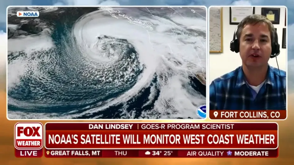
GOES-R Program Scientist Dan Lindsey on how a new satellite is providing groundbreaking images of a Pineapple Express storm system crashing into the California coastline.
Imagery from NOAA weather satellites is displaying the dangerous beauty of the West Coast storm bombing out over California this week.
The images from NASA and NOAA's GOES satellites of the bomb cyclone show the intensity of the swirling atmospheric river system – known as a Pineapple Express because it originates near Hawaii – as it crashes into coastal California.
![A weather system known as an atmospheric river moves over the West Coast on Jan. 4, 2023 as seen by the GOES West satellite.]() Image 1 of 4
Image 1 of 4A weather system known as an atmospheric river moves over the West Coast on Jan. 4, 2023 as seen by the GOES West satellite. (Image: NOAA/RAMMB/CSU) ( )
![The atmospheric river moving over the Pacific Ocean as seen by the GOES West satellite on Jan. 3, 2022.]() Image 2 of 4
Image 2 of 4The atmospheric river moving over the Pacific Ocean as seen by the GOES West satellite on Jan. 3, 2022. (Image: NOAA/NASA) (RAAM-B / CIRA)
![NOAA satellite GOES West (GOES 18) observers the cooling cloud tops in RGB of the atmospheric river slamming into the West Coast on Jan. 4, 2023, the first day of the satellites new operational period.]() Image 3 of 4
Image 3 of 4NOAA satellite GOES West (GOES 18) observers the cooling cloud tops in RGB of the atmospheric river slamming into the West Coast on Jan. 4, 2023, the first day of the satellite's new operational period. (Image: NOAA) ( )
![]() Image 4 of 4
Image 4 of 4The NOAA GOES-18 satellite shows water vapor over the U.S. Pacific Coast on Jan. 4, 2023. (Image: NOAA) ( )


NOAA's GOES-West satellite monitors the U.S. Pacific Ocean and has been keeping an eye on the weather system as it moves closer to California.
GOES-West, also known as GOES-17, has a suite of instruments that can measure different weather elements, including water vapor, smoke, and lightning flashes.
HOW NOAA'S NEW GOES SPACECRAFT WILL IMPROVE SPACE WEATHER FORECASTING
NOAA's Cooperative Institute for Meteorological Satellite Studies at the University of Wisconsin-Madison shared GOES-West images of the massive stream of water vapor trekking across the Pacific Ocean as it steamrolled into the U.S. Pacific Coast.
Over the past day, GOES-West watched as the storm underwent rapid intensification, becoming a bomb cyclone and tapping into the Pineapple Express atmospheric river.
The satellite even continues to observe Earth during the night, which is how it captured this image of the West Coast storm and the Aurora Borealis on Tuesday night.
New GOES-West takes over monitoring bomb cyclone
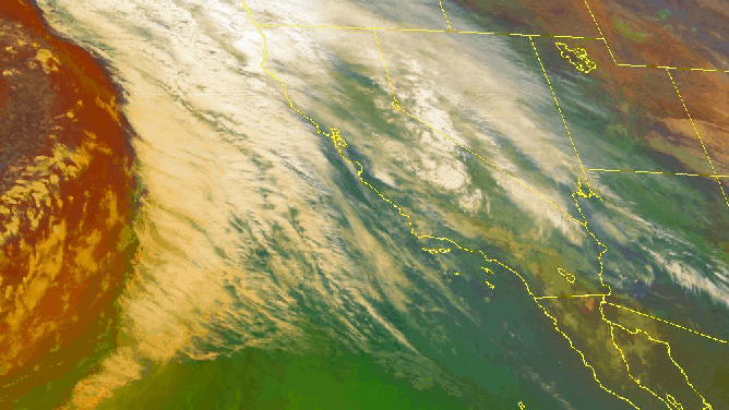
The NOAA GOES-18 satellite shows water vapor over the U.S. Pacific Coast on Jan. 4, 2023. (Image: NOAA)
(NOAA)
The satellite imagery on the West Coast got an upgrade just in time for this potentially life-threatening storm as NOAA's newest weather satellite came into operation this week.
The most recent GOES satellite, GOES-18, launched in March 2022 and began sending back images in June. After nearly 10 months of commissioning, NOAA transitioned GOES-18 as the new operational GOES-West satellite on Wednesday.
GOES-West orbits the Earth 22,236 miles above the equator over the Pacific Ocean using its suite of instruments to monitor the weather and climate in the western U.S., Canada, Alaska, Hawaii, Mexico and Central America.
According to NOAA, GOES-17 will be placed into "storage mode" on standby should it need to be called up for use.
The GOES program began in 1975 when the first satellite known as GOES-A launched from Cape Canaveral.