Bryan Norcross: Atlantic Tropical Disturbance - Invest 94L - looks likely to develop next week
The system is slowly progressing to the west in the general direction of the Caribbean, although it's still over 2,300 miles away from the islands.

FOX Weather is your Hurricane HQ, streaming free 24/7.
(FOX Forecast Center / FOX Weather)
Updated Friday 9:15 a.m ET
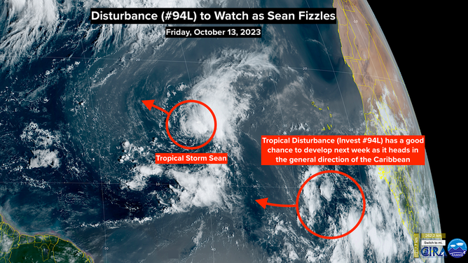
A large but extremely disorganized Tropical Disturbance on the far side of the Atlantic - officially tagged Invest 94L - has our attention because of its extremely low latitude. Currently, it's a broad circulation interspersed with a few thunderstorm clusters that's infiltrated by dry air.
The system is slowly progressing to the west in the general direction of the Caribbean, although it's still over 2,300 miles away from the islands. The disturbance's low latitude means it's less likely to turn north in the short term.
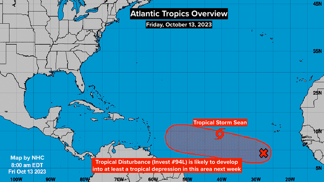
The consensus of the various computer forecasts is that the disturbance will continue west for the next several days. Then about the middle of next week, things get fuzzy. The National Hurricane Center gives the system a high chance of developing into a tropical depression or Tropical Storm Tammy in the 7 days.
Disturbance to watch as Sean fizzles.
(CIRA / RAMMB / FOX Weather)
On the current schedule, the system would be in the general vicinity of the eastern Caribbean islands at the end of next week or over that weekend. Obviously, a lot can happen in that amount of time. The atmospheric pattern over the Atlantic to the east of the islands is forecast to be conducive for the system to organize and intensify. But there is a large spread in the track possibilities ranging from affecting the islands directly to turning north into the Atlantic.
As always, long-range forecasts for undeveloped, just-developing, and slow-moving systems are prone to large errors and are likely to change.
For now, everybody in the islands should plan to stay informed about the progress of the system next week.
Just ahead and to the north of the disturbance, Tropical Storm Sean perked up a bit yesterday, but it's still a short-timer. The storm is forecast to die out and dissipate in the next few days in the central Atlantic.
Atlantic Tropics Overview
(National Hurricane Center / FOX Weather)
After record heat in South Florida the last few days (and for most of the summer), the first robust cold front of the year is expected to sweep down the peninsula about Sunday. The surging continental air mass will push the humid tropical air into the Caribbean. Another cold front is tentatively on the schedule for next week.
As long as the cold fronts are coming south, generally speaking, storms will stay away from Florida and the surrounding states. That's not 100% - nothing ever is. But it's a decent rule. On the other hand, it's not over until it's over. So we continue to pay attention.