Bryan Norcross: Caribbean disturbance named Invest 93L a threat to Florida’s Gulf Coast
The most important thing to do at the current time is to stay informed. Tropical Storm or Hurricane Watches will likely be issued on Monday. Storm surge alerts are also possible, depending on the forecast strength of the storm.

FOX Weather is your Hurricane HQ, streaming free 24/7.
(FOX Weather / FOX Weather)
The Tropical Disturbance in the Caribbean has been officially tagged Invest #93L by the National Hurricane Center. The designation means that they are deploying extra computer resources to "investigate" the system. They’re giving the disturbance a high chance of developing into at least a tropical depression, but the consensus of the computer forecasts is that it will likely develop into a tropical storm and possibly a hurricane.
The steering currents are very light over the Caribbean at the current time, which means the system will move slowly for the next couple of days, strolling north in the vicinity of Mexico’s Yucatán Peninsula. By Monday evening, the system should be in the southern Gulf of Mexico as a tropical depression or perhaps Tropical Storm Idalia. (There’s some chance it could be Tropical Storm Jose if the system in the Atlantic develops first.)
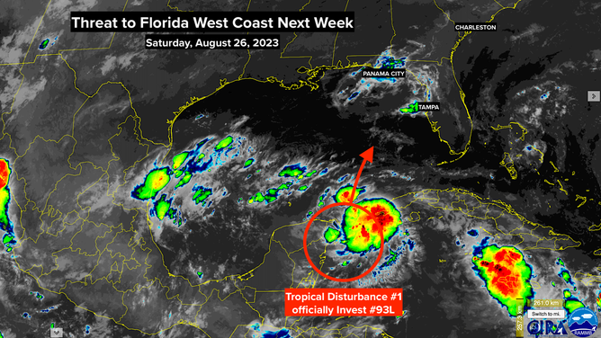
Threat to Florida West Coast.
(CIRA / NOAA)
By Tuesday, a strong dip in the jet stream is forecast to reach into the Gulf of Mexico and scoop up the system. It should move relatively quickly to the north, reaching the Florida coast on Wednesday on the current schedule.
Since it will be moving parallel to the Florida west coast, a slight angle difference in its track will significantly affect where the center makes landfall. The consensus at the current time is that the center of circulation will cross the coast between Panama City and Tampa. But it’s important to note that forecasts for undeveloped, just-developing, and slow-moving systems are subject to larger-than-normal errors and often change.
Portions of the Florida Gulf Coast, especially ahead and to the right (to the south) of where the center comes ashore, are likely to be impacted by gusty winds, periods of heavy rain, and storm surge at the coast and in the bays and rivers. The question is the level of impact.
On the good side, the system will be moving relatively quickly, so it won’t have a lot of time to grow terribly large and intense. On the other hand, it will be over the very warm waters of the Gulf of Mexico.
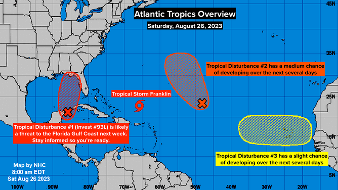
Atlantic Tropics Overview.
(NHC / NOAA)
The biggest unknown is how the scoop – the dip in the jet stream – is going to interact with the system. If the core of the upper winds is just west of the system, it could help it intensify more quickly. If the strong river of air is over the circulation, the winds would more likely stretch the system by smearing the moisture along its path. That would limit the intensification process. It’s too early to know exactly how the interaction will play out.
This storm will likely impact Georgia and the Carolinas as well. It’s too early to know if it will be a weakening system over land or a significant storm along the coast, however. Be sure to stay informed there as well.
The most important thing to do at the current time is to stay informed. Tropical Storm or Hurricane Watches will likely be issued on Monday. Storm surge alerts are also possible, depending on the forecast strength of the storm. And remember, the impacts from the storm will extend well outside the cone, as they always do on the west coast of Florida.
In the Atlantic, Hurricane Franklin is expected to track between Bermuda and the U.S. East Coast. The biggest effect in the U.S. will be dangerous surf and rip currents at the beaches. Bermuda will most likely get a fringe effect from the storm, but they will have to watch it closely. The latest forecasts show Franklin curling around the island – too close for comfort.
There are two other systems to watch in the eastern Atlantic, but none appear to be a threat to land at this time.