Magnitude 4.5 earthquake felt across 178 zip codes along Oklahoma-Kansas border
The Oklahoma Corporation Commission's Induced Seismicity Department is investigating the earthquake.
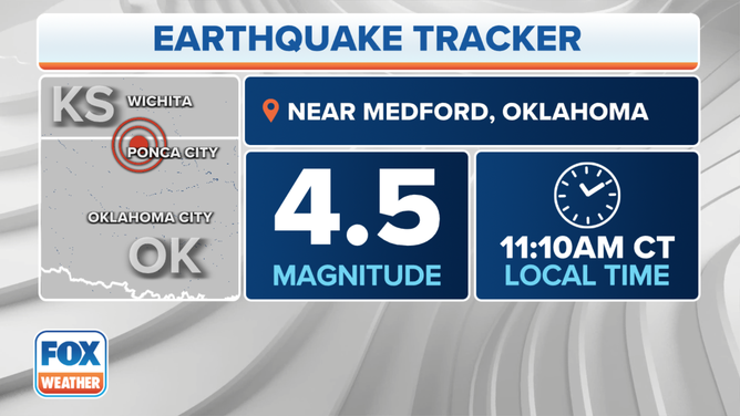
A magnitude 4.5 earthquake was felt in Oklahoma and Kansas on Monday, Jan. 31, 2022.
(FOX Weather)
A magnitude 4.5 earthquake was felt across Oklahoma-Kansas stateliness Monday morning, with multiple reports of buildings shaking as far away as Kansas City.
The U.S. Geological Survey reported the quake happened at about 11:10 a.m. Central time. According to the USGS, the epicenter was about 4.5 miles northwest of Medford, Oklahoma.
Initial ratings put the quake at magnitude 4.6, which would have been the 12th strongest on record for Oklahoma, but the USGS later revised the rating to 4.5 – still the state's strongest since 2019.
The USGS collects reports from people who felt the earthquake on its interactive map. If you felt it, click here to add your report.
According to the USGS map, reports were sent in from Witchita, Kansas, southward to Tulsa and Oklahoma City, Oklahoma. More than 2,700 responses were submitted across 178 zip codes.
The National Weather Service in Tulsa reported feeling a big earthquake.
Since 2009, Oklahoma began experiencing more earthquakes induced by oil and gas processes. According to the USGS, most quakes in Oklahoma are triggered by a process known as "wastewater disposal," when fluid waste from oil and gas is injected underground.
The Oklahoma Corporation Commission's Induced Seismicity Department said in a tweet it is investigating the latest earthquake.
Reports on the USGS map were closest to the Wakita Trend Gas Field and the Cherry Vale Oil and Gas Field.