Tropical development threat fades but heavy rains maintain flooding threat along Gulf Coast
Flood Watches are in effect for parishes along the Gulf Coast to north of Interstate 10, and NOAA's Weather Prediction Center even expects a likelihood of flash flooding between New Orleans and the Texas-Louisiana border.

Invest 93L bringing rounds of rain, flood threat to New Orleans
Chances of 93L developing into a tropical depression over the next two days are low but the system is still bringing a flood threat to Louisiana. FOX Weather Meteorologist Bayne Froney has the latest from New Orleans.
MOBILE, Ala. – The threat of tropical development along the Gulf Coast has faded as what was designated as Invest 93L moved inland Thursday, but the region is still facing a surge of tropical moisture and threatens to produce heavy rainfall along the Interstate 10 corridor into the weekend.
Earlier this week, Florida was the recipient of the heavy rainfall, but the chances of precipitation have now shifted westward and will continue to impact communities in Alabama, Mississippi and Louisiana through at least Saturday.

Warning boxes are color coded as: Severe Thunderstorm Warnings in yellow, Tornado Warnings in red, Tornado Warnings with confirmed tornado in purple, Flash Flood Warnings in green, and Flash Flood Emergencies in pink.
(FOX Weather)
The greatest impacts from the system remain heavy rainfall, flooding, occasional waterspouts and rough seas.
The FOX Forecast Center expects squally conditions to last through the weekend, with Friday into Saturday being the time period with the heaviest rainfall.
Flood Watches are in effect for parishes along the Gulf Coast to north of Interstate 10, and NOAA's Weather Prediction Center even expects a likelihood of flash flooding between New Orleans and the Texas-Louisiana border.

(FOX Weather)
Computer forecast models show a widespread swath of 1-3 inches of rainfall from east of Houston to Panama City, Florida, with amounts of 5-8 inches and even greater around Lafayette, Louisiana.
Just 6 inches of moving water can knock an adult off their feet, while a foot of floodwater can cause a vehicle to stall and float away.
Severe weather such as waterspouts and tornadoes could also be possible in the stronger cells.

Flood threat remains despite Invest 93L's low development odds
The chance for Invest93L to develop further has dropped once again, but the chance for heavy rain to bring flooding to the Gulf Coast persists. FOX Weather Correspondent Robert Ray reports from New Orleans on what to expect.
Tropical moisture causes problems in Florida and along Gulf Coast
The combination of Florida's daily afternoon thunderstorms and tropical moisture associated with Invest 93L caused problems throughout the Sunshine State during its brief interaction with the system.
On Saturday, St. Johns County Fire Rescue reported three people were injured Saturday afternoon when lightning struck the St. Augustine Beach Pier.
The agency said one person suffered critical injuries and was airlifted to a trauma center, while another person was taken to a local hospital with non-life-threatening injuries.
A third person was also reported to have been evaluated but refused medical transport.
And farther south, east of Tampa, nearly a foot of rain fell within a few hours in Plant City on Monday, causing streets and homes to be flooded.
Local officials did not report any injuries associated with the flash flooding but did characterize the flooding as a 1-out-of-1,000-year event.
Most other communities reported seeing rainfall totals in the 1- to 4-inch range, with locally higher amounts.
Minor street flooding was also reported in southern Mississippi on Wednesday evening.
Keesler Air Force Base in Biloxi, Mississippi, saw more than an inch of rainfall in just under an hour, causing some ponding on roadways.
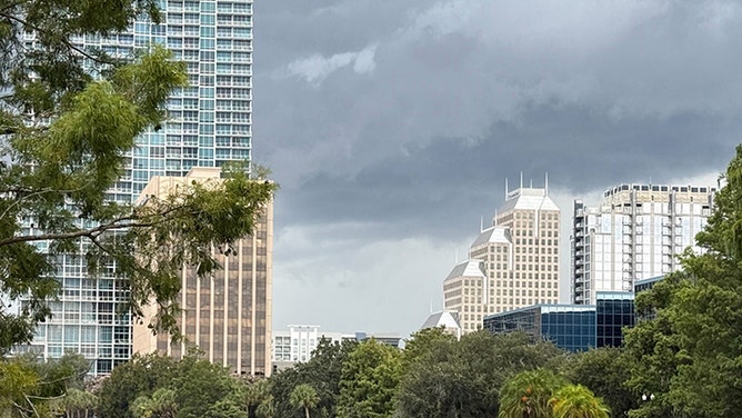
![Torrential rain and relentless downpours from Invest 93L are already soaking parts of Florida, as dark storm clouds enveloped Orlando this Tuesday morning.]() Image 1 of 4
Image 1 of 4Torrential rain and relentless downpours from Invest 93L are already soaking parts of Florida, as dark storm clouds enveloped Orlando this Tuesday morning. (Robert Ray/FOX Weather)
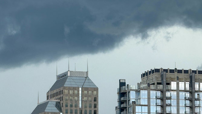
![Torrential rain and relentless downpours from Invest 93L are already soaking parts of Florida, as dark storm clouds enveloped Orlando this Tuesday morning.]() Image 2 of 4
Image 2 of 4Torrential rain and relentless downpours from Invest 93L are already soaking parts of Florida, as dark storm clouds enveloped Orlando this Tuesday morning. (Robert Ray/FOX Weather)
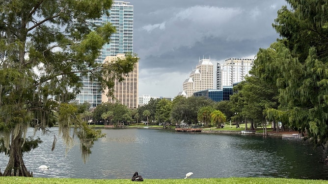
![Torrential rain and relentless downpours from Invest 93L are already soaking parts of Florida, as dark storm clouds enveloped Orlando this Tuesday morning.]() Image 3 of 4
Image 3 of 4Torrential rain and relentless downpours from Invest 93L are already soaking parts of Florida, as dark storm clouds enveloped Orlando this Tuesday morning. (Robert Ray/FOX Weather)
![Torrential rain and relentless downpours from Invest 93L are already soaking parts of Florida, as dark storm clouds enveloped Orlando this Tuesday morning.]() Image 4 of 4
Image 4 of 4Torrential rain and relentless downpours from Invest 93L are already soaking parts of Florida, as dark storm clouds enveloped Orlando this Tuesday morning. (Robert Ray/FOX Weather)