Images and video show Boulder fire devastation in Colorado
First responders battled dangerous 'fire storm' attempting to save neighborhoods
Colorado residents assess wildfire damage among snow, ash
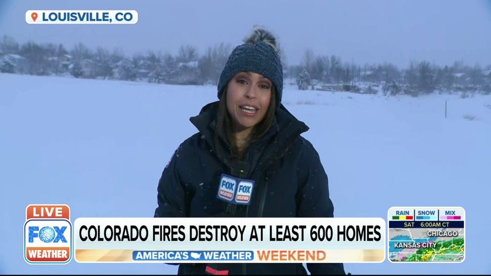
Roughly 30,000 people were forced to evacuate while the wildfires burned in northern Colorado. FOX Weather's Nicole Valdes has the latest update from Louisville.
LOUISVILLE, Co. – Images emerging of the Boulder County, Colorado firefight offer a glimpse into the damages left behind by fires that tore through whole neighborhoods, scorching 6,000 acres.
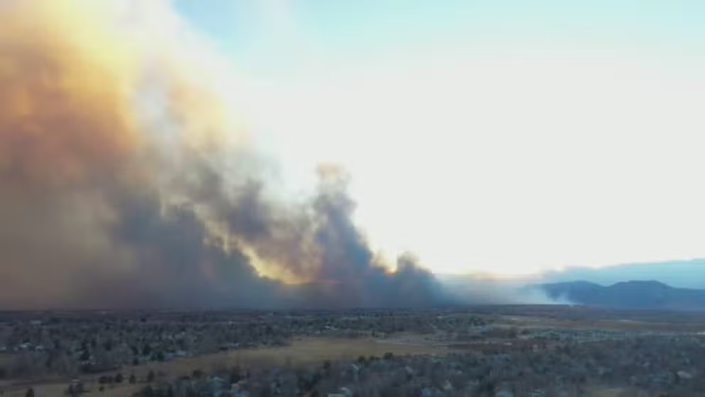
Fires started in multiple locations quickly spread, fueled by fierce winds over 100 mph driving the flames fast across parched grass Thursday, leaving whole communities burned to the ground. More than 500 homes were burned down, but damage assessments are still underway, with 2,000 homes in the burn zone.
Drone footage showed the powerful winds whipping the flames across dry land. The smoke could be seen as far as Denver and was picked up by radar and satellites in space.
UPDATES: Colorado fire burns 6,000 acres; destroys at least 500 homes
Drone footage: Wind-fueled Colorado fires
Drone footage captures fires burning in the area Louisville and Superior, Colorado.
The Middle Fork Fire at North Foothills Highway and Middle Fork Road and the Marshall Fire near South Cherryvale Road and Marshall Drive prompted more than 30,000 people to evacuate. While Colorado is used to wildfires, the Marshall Fire happened in a highly-populated area and spread quickly with little warning.
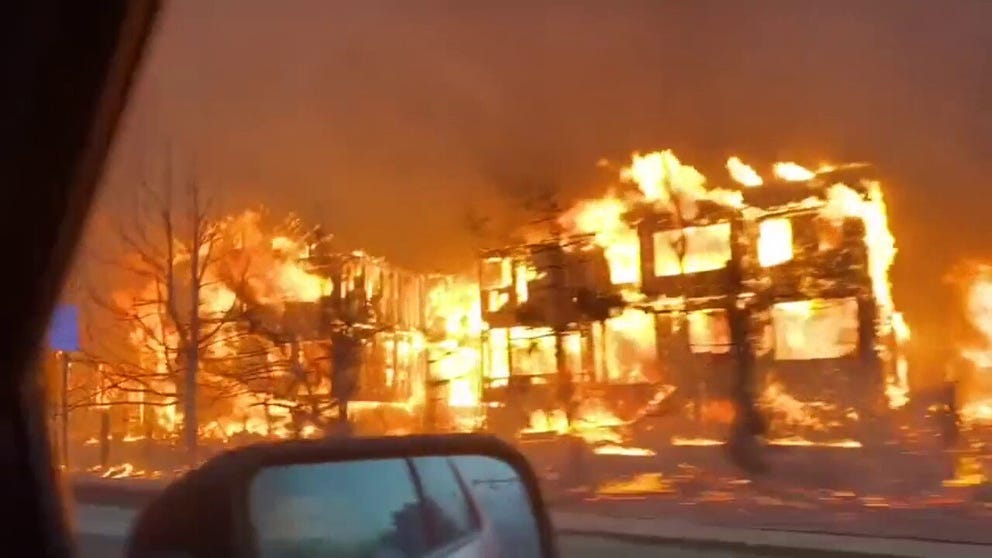
First responders on the ground had a dangerously close view of the powerful fire. Police and firefighters attempting to get people out of the evacuation zone shared videos of whole communities in flames.
Police show patrol footage from Colorado fire
The Broomfield Police Department released this footage from their drive through Superior, Colorado, Thursday afternoon.
Mike Smitty, the fire incident commander, described the fire behavior as "moving as the same speed of the wind." In Boulder on Thursday, wind gusts were reported over 105 mph, with more frequent gusts between 60 and 70 mph for most of the day.
"This was a rapid-fire over a period of hours with gusts of up to 105 miles an hour, leapfrogging instantly over highways, over roads, across neighborhoods, really kind of an alignment of many of the worst possible factors that the firefighters fear," Colorado Gov. Jared Polis said.
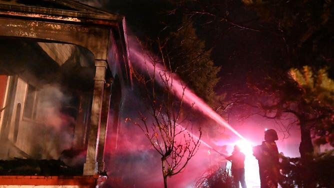
![Fire crew work to put out flames at a home burnt in the Marshall Fire in Boulder County on December 31, 2021 in Louisville, Colorado. (Photo by RJ Sangosti/MediaNews Group/The Denver Post via Getty Images)]() Image 1 of 6
Image 1 of 6Fire crew work to put out flames at a home burnt in the Marshall Fire in Boulder County on December 31, 2021 in Louisville, Colorado. (Photo by RJ Sangosti/MediaNews Group/The Denver Post via Getty Images) ( )
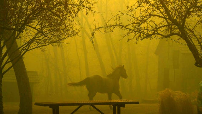
![SUPERIOR, CO - DECEMBER 30: A horse runs through Grasso Park on December 30, 2021 in Superior, Colorado. Fierce winds have whipped wildfires in Boulder County, The towns of Superior and Louisville have been evacuated. Multiple homes and businesses have burned so far from the fast moving fire stocked by fierce winds, with gusts topping 100 mph, along the foothills. The fire has been called the Marshall Fire. The horse was later found by Sheriff deputies and reunited with the owners. (Photo by Helen H. Richardson/MediaNews Group/The Denver Post via Getty Images)]() Image 2 of 6
Image 2 of 6SUPERIOR, CO - DECEMBER 30: A horse runs through Grasso Park on December 30, 2021 in Superior, Colorado. Fierce winds have whipped wildfires in Boulder County, The towns of Superior and Louisville have been evacuated. Multiple homes and businesses have burned so far from the fast moving fire stocked by fierce winds, with gusts topping 100 mph, along the foothills. The fire has been called the Marshall Fire. The horse was later found by Sheriff deputies and reunited with the owners. (Photo by Helen H. Richardson/MediaNews Group/The Denver Post via Getty Images) ( )
![]() Image 3 of 6
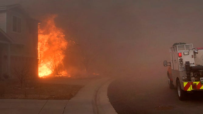
Image 3 of 6SUPERIOR, CO - DECEMBER 30: A brush fire arrives on scene of a fully involved house on December 30, 2021 in Superior, Colorado. Fierce winds have whipped wildfires in Boulder County. The towns of Superior and Louisville have been evacuated. Multiple homes and businesses have burned from the fast moving fire stocked by fierce winds, with gusts topping 100 mph, along the foothills. The fire has officially been named the Marshall Fire. (Helen H. Richardson/MediaNews Group/The Denver Post)
![LOUISVILLE, COLORADO - DECEMBER 31: Fire crew work to put out flames at a home burnt in the Marshall Fire in Boulder County on December 31, 2021 in Louisville, Colorado. (Photo by RJ Sangosti/MediaNews Group/The Denver Post via Getty Images)]() Image 4 of 6
Image 4 of 6LOUISVILLE, COLORADO - DECEMBER 31: Fire crew work to put out flames at a home burnt in the Marshall Fire in Boulder County on December 31, 2021 in Louisville, Colorado. (Photo by RJ Sangosti/MediaNews Group/The Denver Post via Getty Images) ( )
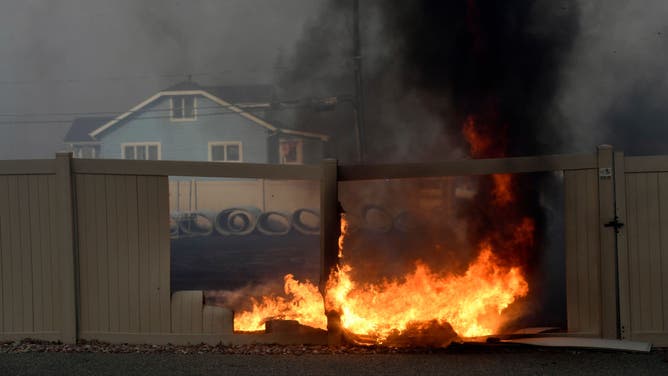
![SUPERIOR, CO - DECEMBER 30: Fires burn fences near structures and homes in the historic downtown area on December 30, 2021 in Superior, Colorado. Fierce winds have whipped wildfires in Boulder County. The towns of Superior and Louisville have been evacuated. Multiple homes and businesses have burned from the fast moving fire stocked by fierce winds, with gusts topping 100 mph, along the foothills. The fire has officially been named the Marshall Fire. (Photo by Helen H. Richardson/MediaNews Group/The Denver Post via Getty Images)]() Image 5 of 6
Image 5 of 6SUPERIOR, CO - DECEMBER 30: Fires burn fences near structures and homes in the historic downtown area on December 30, 2021 in Superior, Colorado. Fierce winds have whipped wildfires in Boulder County. The towns of Superior and Louisville have been evacuated. Multiple homes and businesses have burned from the fast moving fire stocked by fierce winds, with gusts topping 100 mph, along the foothills. The fire has officially been named the Marshall Fire. (Photo by Helen H. Richardson/MediaNews Group/The Denver Post via Getty Images) ( )
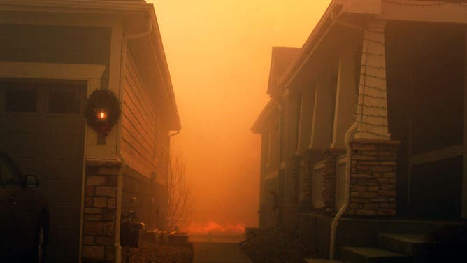
![SUPERIOR, CO - DECEMBER 30: A Christmas wreath hangs on the side of a house where fire creeps towards the back on December 30, 2021 in Superior, Colorado. Fierce winds have whipped wildfires in Boulder County. The towns of Superior and Louisville have been evacuated. Multiple homes and businesses have burned from the fast moving fire stocked by fierce winds, with gusts topping 100 mph, along the foothills. The fire has officially been named the Marshall Fire. (Photo by Helen H. Richardson/MediaNews Group/The Denver Post via Getty Images)]() Image 6 of 6
Image 6 of 6A Christmas wreath hangs on the side of a house where fire creeps towards the back on December 30, 2021 in Superior, Colorado. Fierce winds have whipped wildfires in Boulder County. The towns of Superior and Louisville have been evacuated. Multiple homes and businesses have burned from the fast moving fire stocked by fierce winds, with gusts topping 100 mph, along the foothills. The fire has officially been named the Marshall Fire. (Photo by Helen H. Richardson/MediaNews Group/The Denver Post via Getty Images) ( )

A firefighter with West Metro Fire recorded the video below showing the "fire storm" intensity as they tried to protect a neighborhood engulfed in flames.
After the sun went down Thursday, the orange glow of the fire could be seen for miles. The reality of the damage wasn't obvious until the sun came up Friday, revealing the extent of the firestorms' path.
Broomfield police shared this image of smoke rising from homes in Superior on Friday morning.
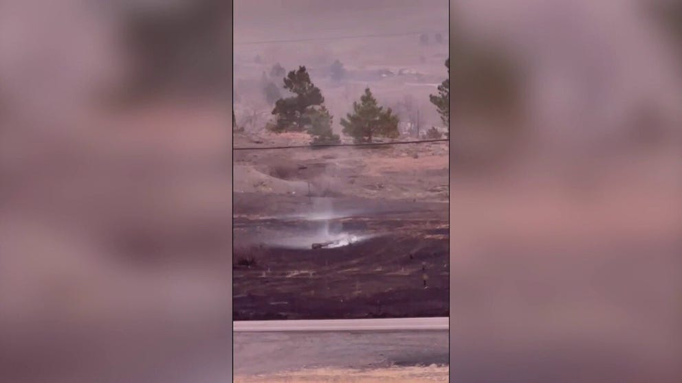
Resident Thomas Quay Williams recorded the video below Friday morning of the smoke still rising from chard homes and grasslands.
Sunrise reveals scorched earth in Colorado after damaging fires
Thomas Quay Williams recorded this footage near Boulder, Colorado, the morning after wildfires destroyed hundreds of homes and led thousands to evacuate.
Evacuees are being told not to return home yet as firefighters were still putting out hotspots Friday. Residents are eager to return to find out what's left of their homes. Aerial video of the burn zone, which stretches 6,000 acres, shows whole streets of houses that are now just holes in the ground.
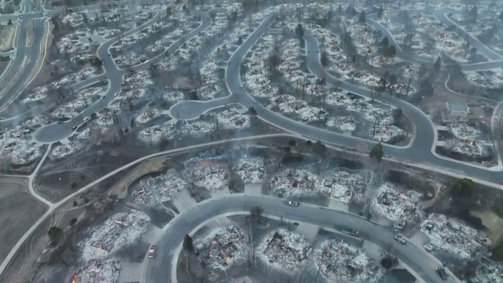
Entire subdivisions burned to slabs from Marshall Fire seen in dramatic aerial video
Nothing but slabs are left for city blocks in Louisville, Colorado, after the Marshall Fire on Dec. 30, 2021. Storm chaser Brandon Clement captured the remains at first light using a drone.
Boulder County Sheriff Joe Pelle said it's a miracle there have been no reported deaths from the fire.
"It's unbelievable when you look at the devastation that we don't have a list of 100 missing persons, but we don't," Pelle said. "I'm hoping that's a miracle because it would be given the circumstances."