Bryan Norcross: Hilary begins impacting Southern California tonight, peaks Sunday
Hilary is forecast to be as bad or worse than any previous modern tropical-system impact.

FOX Weather is your Hurricane HQ, streaming free 24/7.
(FOX Weather / FOX Weather)
The last time a tropical storm directly impacted Southern California was in 1939. The result was destructive flooding from the deserts to the Pacific coast caused by the tropical air interacting with the mountains that crisscross the region.
Tropical Depression Nora made it into California in 1997 on a track to the east of where Hilary is projected to go. It caused significant flooding in the desert and was very disruptive throughout metropolitan Los Angeles. And, over the years, the remnants of a number of tropical systems have impacted the region causing flash flooding.
Hilary is forecast to be as bad or worse than any previous modern tropical-system impact.
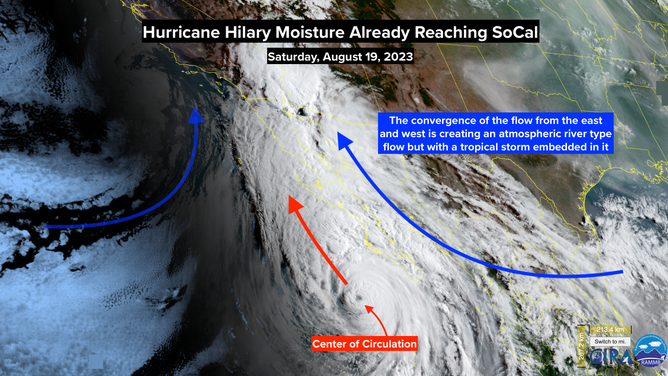
Hurricane Hilary Noisture Already Reaching SoCal. August 19, 2023.
(NOAA / NOAA)
The forecast is unchanged, except the storm is moving a little faster. Moist tropical air will flow from south to north ahead of Hilary. It has already reached San Diego County and will spread north through the day. The rain should begin in Los Angeles County this evening.
Tomorrow will be the day of the biggest impacts. Tropical downpours will overspread the region. The heaviest rain will fall in the mountains, with some areas receiving in the range of 10 inches. At lower elevations, amounts will likely be in the 2 to 5-inch range with isolated spots getting more.
Since the rain is going to come hard over a short period of time, significant flooding is likely. Drainage systems will likely overflow. Freeways, streets, and parking lots may well hold water. Arroyos in the deserts could become raging dangerous rivers.
In addition, the wind will resemble a Santa Ana, but with moisture. In wind-prone areas, expect gusts of 60 mph or more, which can bring down trees and power lines. Power outages are likely.
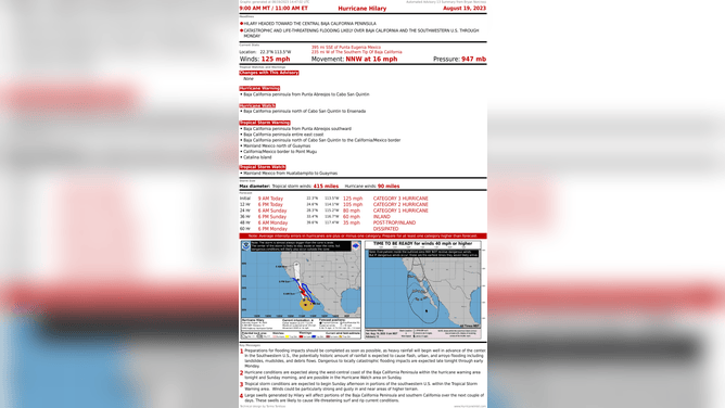
Hurricane Hilary Overview. August 19, 2023.
(NOAA / NOAA)
Plan to stay informed tomorrow and tomorrow night about local information and instructions all across Southern California.
Conditions will improve significantly by Monday afternoon.
In the Atlantic, there are 4 systems we’re watching. From left to right across the map:
Tropical Disturbance #4 is a disorganized cluster of thunderstorms that will pass over South Florida today and tomorrow and move into the Gulf. When is gets to the central Gulf on Monday, the National Hurricane Center gives it a medium chance of developing into at least a tropical depression before it comes ashore on the Texas coast about Tuesday.
It is not expected to get terribly strong, but some gusty winds could accompany it along with beneficial rain for South Texas and the Hill Country. Stay informed.
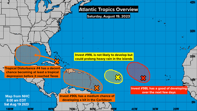
Atlantic Tropics Overview. August 19, 2023.
(NOAA / NOAA)
The Tropical Disturbance approaching the Caribbean (officially now called Invest #90L) is showing signs of organization. As it passes across the eastern Caribbean islands and moves in the general direction of Puerto Rico and the Dominican Republic/Haiti early in the week, some development is possible. The National Hurricane Center is giving it a medium chance of becoming a at least tropical depression.
In any case, it will bring gusty winds and pockets of heavy rain to the islands.
How Invest #99L interacts with Invest #90L is an open question. Moisture from one system might feed into the other, or the combination will produce an extended period of bad weather including gusty winds and excessive rainfall. Plan to say informed in the northeastern Caribbean islands over the next several days. The weather pattern is complex, and the outcome is quite uncertain. Don’t be surprised if the forecast changes for these two systems.
Farther east, the disturbance called Invest #98L has a good chance of developing, but it is not a threat to land.
The peak part of hurricane season begins this week, so everybody in the hurricane zone – which has now expanded to include Southern California and the Southwest – needs to stay aware of the forecasts.