Southeast coastal storm on the move
While impacts are relaxing in Florida and Georgia, coastal North Carolina will see conditions worsen.
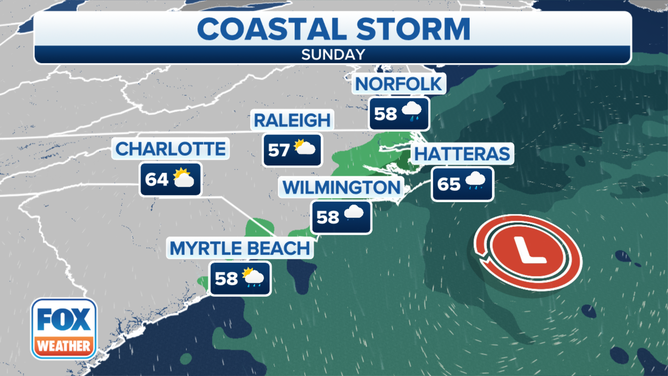
The coastal storm is expected to produce coastal flooding along the North Carolina coastline.
(FOX Weather)
A nor’easter that developed off the coast of Florida continues to make its way eastward, producing rain and winds for the Carolinas.
The prolonged wind event, in combination with the ongoing Kings Tides, is expected to produce coastal flooding from the upstate of South Carolina into the Mid-Atlantic on Sunday.
Coastal areas of North Carolina could see the brunt of the storm system with wind gusts that could approach 60 mph along the Outer Banks, as well as significant flooding along State Highway 12.
The storm system has the National Park Service warning visitors to stay away from the islands until conditions relax.
"Visitors should take this storm seriously as it could be one of the strongest storms of the season," stated David Hallac, superintendent, National Parks of Eastern North Carolina. "If possible, visitors should avoid travel to Seashore destinations until after the storm leaves the area."
Winds and surf will subside during the day on Monday, but tides are expected to remain elevated into the week. Meteorologists say a ridge of high pressure will build into the Southeast, which will help clear out the region and lead to a warm trend.
Charleston sees downtown street flooding
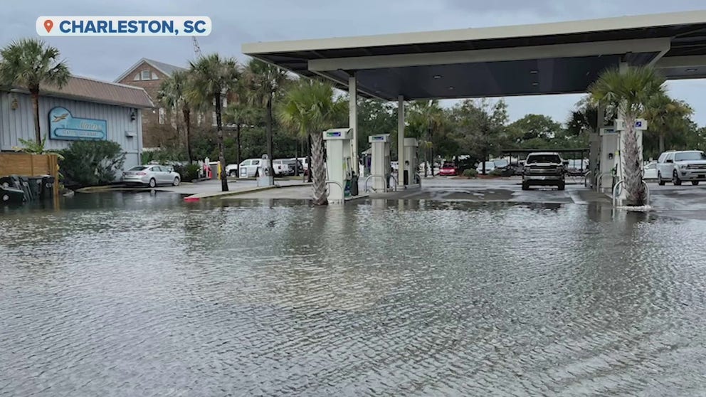
Charleston High Tide Photos
Various locations in downtown Charleston flooded during the nor'easter.
Areas of downtown Charleston saw street flooding on Saturday. Several streets were temporarily closed during high tide.
Both the fire and police department predeployed resources to respond to flooding issues but as of Saturday evening, most roadways were reopened.
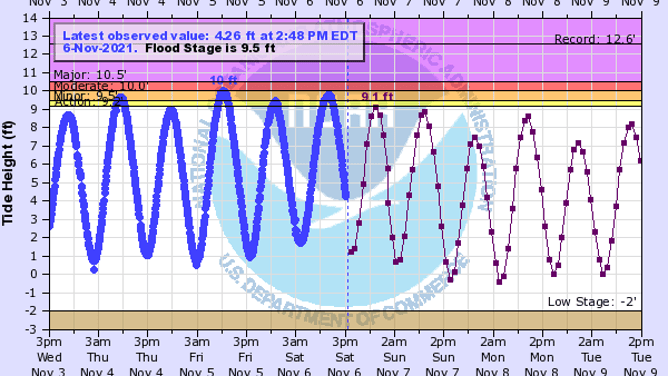
The water gauge on the eastern shore of the city reached major flood status with tide levels reported around 8.44 feet. Saturday's peak was the eleventh highest tide in the city's history.
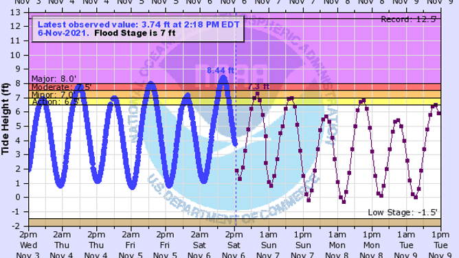
Tide levels reached the eleventh highest on record at 8.44 ft
(NOAA)
Savannah-area gauges reaches moderate flood stage
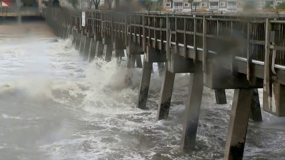
Tybee Island Timelapse
A nor'easter increased tides along the Southeast coast.
The tidal gauge near the mouth of the Savannah River reached moderate flood status on Saturday morning.
The tide level reached 10 feet at Fort Pulaski.
Saturday's high tide was the eighteenth highest crest of all time in the coastal region.
The nor'easter did not produce anywhere near the impact Hurricane Matthew did back on October 8, 2016.
The tide level during the category one hurricane reached 12.56 feet, which is the record as the greatest tide of all-time in the region.
The Fort Pulaski gauge reached moderate flood stage.
(NOAA)
Areas along the Highway 80 corridor did see flooding, but the main thoroughfare between Tybee Island and the mainland stayed open.
Chatham County Emergency Management had crews monitoring the low-lying areas.
Drivers did venture into floodwaters but as of Saturday evening, there were no major issues reported on Tybee Island or in Savannah.
Northeast-Florida impacted by coastal erosion, high surf
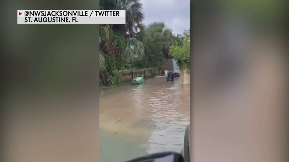
St. Augustine Coastal Flooding
Areas of Northeast Florida saw significant coastal impacts from the nor'easter.
The nation's oldest city is not immune to seeing impacts during high tides. Several roadways were shut down in St. Augustine as tides rose to their highest levels in years.
The combination of rains and the high tides made several streets look like waterways near the Bridge of Lions.
Much of the floodwater receded on Saturday; however, the nor'easter left its mark on Northeast Florida beaches. Significant erosion was reported from Ponte Vedra Beach to St. Augustine Beach.