More than 20 million in the bull's-eye for severe weather on Sunday
Missouri, Kansas and Arkansas could see baseball-size hail and potentially damaging wind gusts up to 60 mph on Sunday. The severe weather threat shifts east on Monday into the Mid-Atlantic and along the I-95 Corridor.

Severe thunderstorms forecast for Central US on Sunday
Multiple rounds of severe storms will be possible from the Plains to the Mid South on Sunday with the greatest potential for tornadoes in southern Missouri and southeast Kansas.
Rounds of severe thunderstorms will potentially bring large hail, damaging winds and the threat of tornadoes to the Central U.S. beginning on Sunday.
The biggest threat for severe weather on Sunday will be from southeast Kansas through southern Missouri into far northern Arkansas.
Where are the storms now?

(FOX Weather)
Severe Thunderstorm Watches have been issued for several parts of the country through the evening.

(FOX Weather)
Sunday's severe weather forecast
The National Weather Service Storm Prediction Center issued an Enhanced Risk, a Level 3 out of 5 risk zone, for cities including Springfield and Joplin, Missouri and Rogers, Arkansas.
A Slight Risk, or Level 2 out of 5 risk zone, is in place for Kansas City, Memphis and Nashville, Tennessee and Tulsa, Oklahoma.

(FOX Weather)
Kansas City will start out the day with storms firing off in the distance, pushing in along Interstate 70.
US SEVERE THUNDERSTORM WARNING MAP
A Flood Watch is in effect through Sunday night for southwest Missouri, including Springfield and Lebanon.
Rounds of rain will create the potential for flooding, with isolated areas receiving up to 3 inches through Tuesday morning.

Flash flood threat forecast.
(FOX Weather)
The greatest potential for tornadoes will be in southern Missouri and southeast Kansas on Sunday, where wind gusts as high as 60 mph could cause damage.
Cities inside the Enhanced risk area could receive large hail up to 3 inches. The FOX Forecast Center is tracking a very likely hail threat in Wichita, Tulsa and St. Louis.
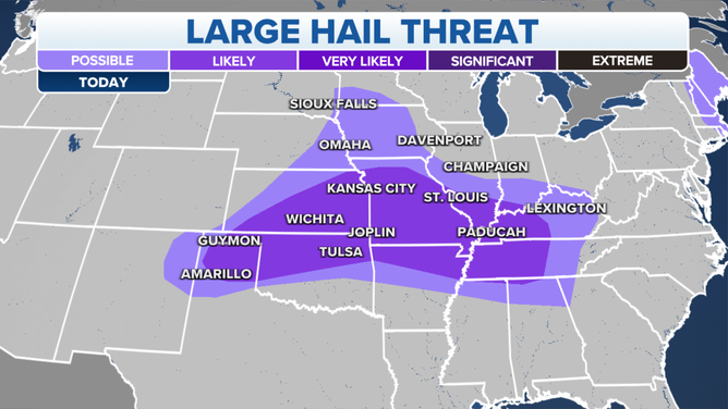
Sunday hail threat forecast for Central U.S.
(FOX Weather)
Looking ahead
Into the workweek, an area of low pressure will move over Illinois shifting the severe weather threat into the Ohio Valley and Mid-Atlantic. As the system marches south, severe storms will fire up ahead of a cold front throughout Monday.
Once again, damaging wind gusts will be the primary threat, but the possibility of a tornado or two cannot be ruled out.
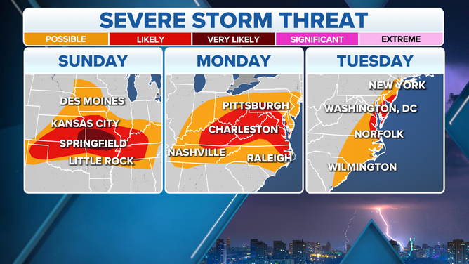
Multi-day severe storm threat forecast.
(FOX Weather)
Further east, the FOX Forecast Center is tracking heavy rain across the already water-logged Interstate 95 corridor with some potentially embedded severe thunderstorms.
The severe weather potential continues Tuesday for the mid-Atlantic and Carolinas.