Bryan Norcross: Caribbean islands watching developments with Atlantic Tropical Disturbance Invest 94L
If the system were to threaten the islands, on the current schedule it would arrive in the vicinity of the northeast Caribbean Friday or Saturday of next week.

FOX Weather is your Hurricane HQ, streaming free 24/7.
(FOX Forecast Center / FOX Weather)
The large Tropical Disturbance – officially tagged Invest #94L – on the far side of the Atlantic has lots of runway and a generally conducive atmospheric pattern ahead to develop into at least a tropical depression. The National Hurricane Center is giving it a high chance of organizing over the next 2 or 3 days. The consensus of the computer forecast models is that the system will strengthen into Tropical Storm and possibly Hurricane Tammy as it tracks west in the general direction of the Caribbean.
If the system were to threaten the islands, on the current schedule it would arrive in the vicinity of the northeast Caribbean Friday or Saturday of next week.
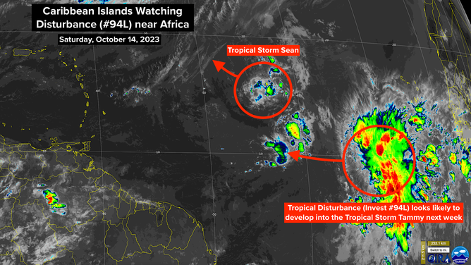
Caribbean Islands Watching Disturbance Near Africa. Oct. 14, 2023.
(CIRA / RAMMB / FOX Weather)
The three main variables are:
1: The strength of the system. The sooner it intensifies, the sooner it will turn north according to the long-range computer-forecast consensus.
2: The blocking high to the north. The high will hold the system south so it tracks toward the islands, but slight variations in its strength can make just enough difference in the angle of the track to change the effects on the islands.
And 3: The cold front and the accompanying dip in the jet stream moving off the East Coast of the U.S. early next week. This system will push the blocking high out of the way and provide a path north for the tropical storm or hurricane. The question is the timing. Where is the storm when that path opens up?
There is no concern that this system might affect the U.S. or surrounding areas. The wintertime pattern taking over the eastern part of the country will divert any tropical systems for now, at least.
Everybody in Puerto Rico and the northeastern Caribbean islands should stay informed this week. As always, forecasts for tropical systems that are just developing are subject to large fluctuations, so don’t grab onto any one idea until we see where exactly the system organizes. In a few days, we’ll likely have a forecast cone and the threat zone, if there is one, will be better defined.
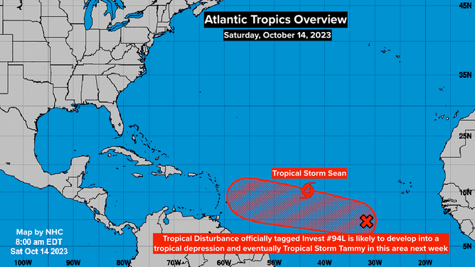
Atlantic Tropics Overview. Oct. 14, 2023.
(National Hurricane Center / FOX Weather)
Miniscule Tropical Storm Sean is slowly fading away to the northeast of the disturbance. It should dissipate in a day or two.
Sean got going farther east in the tropical Atlantic than any previous system in the record book. So yes, it’s late in the year to have a threat coming from the deep tropical Atlantic. It’s not unheard of in October, but by the middle of the month, this formation zone normally shuts down. No doubt, this year’s extra-warm ocean temperatures have something to do with it.