Bryan Norcross: What to think about Hurricane Season 2023 and the updated forecast
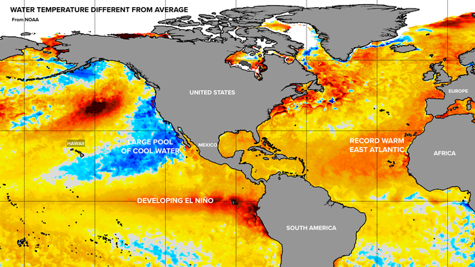
The eastern Atlantic Ocean is drastically warmer than average. In isolation, this factor is like pouring gas on a fire. More energy is available for disturbances to develop and get stronger than they otherwise would.

Generic Hurricane HQ
(FOX Weather)
Updated Monday 8 a.m. EDT
The average water temperature of the Earth’s oceans is in record territory, but it’s where the pools of extremely warm and cold water are located that’s making predictions about this hurricane season trickier than usual.
In the last 40-plus years, we have never seen this warm and cool water distribution, so good correlations with past hurricane seasons can’t be made.
Global water temperatures.
The eastern Atlantic Ocean is drastically warmer than average. In isolation, this factor is like pouring gas on a fire. More energy is available for disturbances to develop and get stronger than they otherwise would.
On the other hand, the developing warm pool of water along the equator south of Hawaii is indicative of an oncoming moderate-to-strong El Niño. This factor would typically limit hurricane development by creating more-hostile-than-normal atmospheric conditions across the tropical Atlantic.
The thinking has been that these two factors would cancel themselves out, more or less, so the total numbers would end up somewhere around average or maybe a little above.
However, there’s a big cold pool of water between Mexico and Hawaii. This is related to a cyclical process in the Pacific separate from El Niño. In their latest analysis, researchers at Colorado State University are thinking that the cool water might take the edge off El Niño, even if it gets strong.
Much was made of the updated CSU forecast last week, which called for 18 named storms and nine hurricanes, with four being Category 3 and above. But numbers can be misleading, so let’s look at them individually.
If we end up with 18 named storms as forecast, the rest of the hurricane season would be about average in that department. We’ve already had Arlene, Bret, Cindy, and a January subtropical storm that was designated posthumously. That would mean that 14 named storms have yet to occur.
The average number for an entire season is 14, with one having formed by this date. So if all those stats are correct, normally, 13 named storms form from now until the end of the season. It's not much different from what’s predicted.
There’s more.
The average of 14 is taken over the years 1991 to 2010. In the 1990s, the technology for detecting storms was much cruder than it is today. And from 1991 to 1994, we were at the tail end of a downturn in tropical activity substantially caused by European air pollution over the tropical Atlantic combined with volcanic activity. If you look at the average activity from 1995 to 2022, 15 or 16 storms becomes normal.
So 14 named storms from now until the end of the season are about typical for this era. It wouldn’t be "extra-active" in terms of named storms as some headlines indicated.
The hurricane numbers, however, tell a different story. They are significantly above normal, and all the hurricanes have yet to occur. The thinking is that the extra heat in the Atlantic will boost systems that otherwise would have stayed in tropical-storm range up to hurricane strength. And similarly, more hurricanes will intensify to Category 3 and above.
There is some solace in the fact that more storms typically turn north into the open Atlantic during El Niño years. But the most important takeaway is that this season’s distribution of climate-affecting water temperatures is new, making seasonal predictions even more uncertain than normal.
In any case, preparations are required everywhere in the hurricane zone.
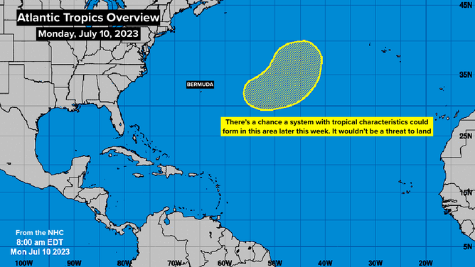
The National Hurricane Center is monitoring an area in the Atlantic.
(NHC)
Today in the middle of the Atlantic, the National Hurricane Center is noting an area for potential development. The system would be generated from non-tropical processes but could evolve into a named system later this week. It’s not a threat to land.
If it develops, this system will be over one of the few parts of the Atlantic that’s not super warm. And if it tracks as forecast, it will soon run into cold water. So its window of time to develop is short.
Otherwise, the atmospheric pattern is hostile to tropical development this week, as it usually is this time of year.