Two Atlantic disturbances have a good chance to develop
It looks like August is going to end having produced no named tropical systems. This is exceptionally rare in a La Niña year.
The podcast Tracking the Tropics with Bryan Norcross is now available to stream.
(FOX Weather)
Updated at 8:30 A.M. EDT
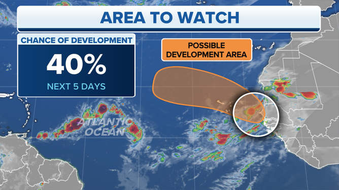
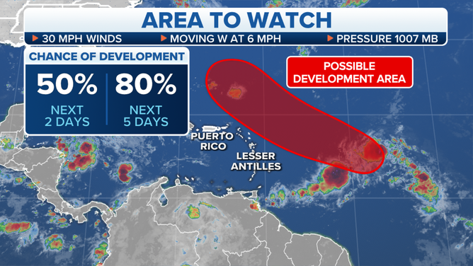
Tropical Disturbance #1 has an elongated, oval-shaped circulation with a robust cluster of thunderstorms at each end of the oval. The upper-level winds are conducive for development, and the ocean water under the disturbance is plenty warm. On the negative side, plentiful dry air covers that part of the Atlantic. That and the oblong circulation will limit how quickly the system can organize.
The oval shape of the system is the legacy of its origin. This combo disturbance formed from a disturbance that moved off Africa, which pulled an area of disturbed weather to the south into its orbit. Now those two original systems are fighting for dominance and slowing the development of an organized tropical system.
The strong consensus of the computer forecast models is that the system will develop into a tropical depression or tropical storm in the open ocean north of Puerto Rico and east of the Bahamas. The open question is, where is the consolidated circulation going to form, assuming the models are correct?
HOW TO WATCH FOX WEATHER ON TV
If the southern cluster of storms ends up dominating and a final circulation forms around that, the track could be much closer to the northeastern Caribbean islands than if a more northerly part of the system wins the consolidation contest.
Tropical Disturbance No. 1
(FOX Weather)
For now, nothing is moving fast. The system isn’t expected to be in the vicinity of the islands until late in the week. As we’ve seen, forecasts for disorganized or just-developing systems are subject to much larger errors than those for hurricanes. So everyone in the islands should stay informed until we see how and where the system consolidates if it does.
On the far side of the Atlantic, Tropical Disturbance #2 has moved off Africa. The steering currents are forecast to fairly quickly turn the system north. It has just a short window of opportunity to organize into a tropical depression or tropical storm before it reaches colder waters. It is not a threat to land.
The potential system that had a chance to develop in the extreme western Caribbean is now expected to move through Central America as a moisture surge. The area of low pressure that spans from the Caribbean to the Pacific was a component of the possible development near the Yucatán. It now appears the consolidated system will form in the Pacific, so the potential-development area is off the map.
Tropical Disturbance No. 2 off Africa.
(FOX Weather)
HOW TO DOWNLOAD THE FOX WEATHER APP
The small non-tropical swirl we were tracking in the waters east of Bermuda is no longer given a chance for tropical development.
We have to keep an eye on Tropical Disturbance #1 just to be sure it stays north of the Caribbean islands and well offshore of the U.S. That’s the consensus of the forecast computer models, but disorganization and slow movement always add some extra uncertainty to the forecast.
It looks like August is going to end having produced no named tropical systems. This is exceptionally rare, and unheard of in a La Niña year when, historically, the environment over the tropical Atlantic is extra-conducive for systems to develop. Dry air has been the culprit. Though why the dry air has persisted is an open question.
For now, we’re good.
FOX Weather Hurricane Specialist Bryan Norcross has a podcast, Tracking the Tropics with Bryan Norcross, available now on FOX News Audio. You can get it on your device by clicking here.