Tropics eerily quiet in what's normally a busy stretch in September
The tropical Atlantic is mostly a ghost town with lots of dry air and bands of hostile upper winds. There are a couple of disorganized disturbances at the edge of the map, so we do have something to watch.
The podcast Tracking the Tropics with Bryan Norcross is now available to stream.
(FOX Weather)
Updated 9:40 a.m. EDT
After producing back-to-back hurricanes – Danielle and Earl – Mother Nature is catching her breath. The tropical Atlantic is mostly a ghost town with lots of dry air and bands of hostile upper winds. There are a couple of disorganized disturbances at the edge of the map, so we do have something to watch.
HOW TO WATCH FOX WEATHER ON TV
Tropical Disturbance #1 is a disorganized cluster of clouds and showers moving in the direction of the Caribbean islands. It is caught under a blocking high-pressure system, so it's more likely to continue to the west than the systems so far this year that have turned north.
The disturbance should arrive at the Caribbean islands late in the week. The consensus of the computer forecast models is that it will come through the islands as a moisture surge. Next week, however, there's a slight chance it will be a system to watch in the western Caribbean.
After producing back-to-back hurricanes – Danielle and Earl – Mother Nature is catching her breath.
(FOX Weather)
It's far too early to forecast anything specific. The National Hurricane Center is not mentioning the disturbance at this point because their map only covers systems with a chance to develop in the next 5 days. This one is of a little extra notice because it appears the high-pressure system to the north will drive it west into the Caribbean, which has been infrequent lately. We'll see what happens next week.
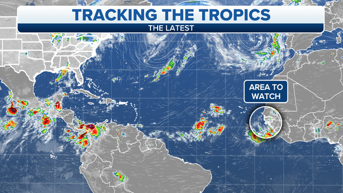
Tropical Disturbance #2 is a robust area of disturbed weather that will move off Africa later today or tomorrow. Once it is over the Atlantic, it has a slight chance to organize into at least a tropical depression. The current consensus of the computer forecast models is that this system won't amount to much and will turn north into the central Atlantic. But of course, we'll watch to be sure.
HOW TO DOWNLOAD THE FOX WEATHER APP
The long-range computer forecast models don't show any apparent threats developing into next week. The Atlantic continues to be hostile to systems developing. The moisture is congregated in the western Caribbean and the southern Gulf of Mexico. These areas are likely to be our focus in the weeks to come.
FOX Weather Hurricane Specialist Bryan Norcross has a podcast, Tracking the Tropics with Bryan Norcross, available now on FOX News Audio. You can get it on your device by clicking here.