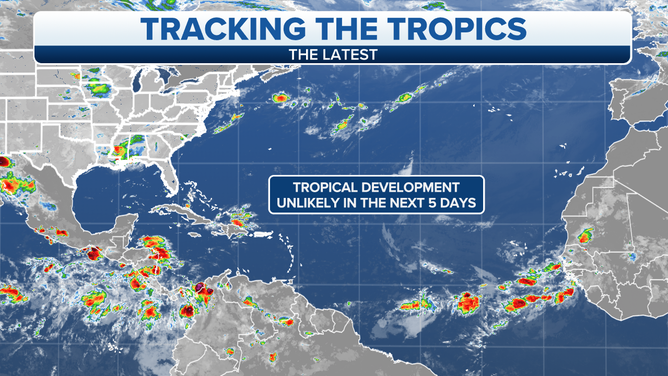
Tropics forecast to stay quiet into the middle of next week
Even with a quiet July, we’re still ahead of normal. On average, the third named storm doesn’t form until August 3rd, so nothing unusual is going on.

The podcast Tracking the Tropics with Bryan Norcross is now available
Updated at 9:45 a.m. ET
A hostile weather pattern over the tropical Atlantic, Caribbean Sea, and the Gulf of Mexico has kept any systems from developing this month. Flash-in-the-pan Tropical Storm Colin developed over the South Carolina coast in early July, but that system didn’t originate out of the tropics.
A large outbreak of dust from the Sahara Desert in Africa has covered a good part of the tropical Atlantic for most of the month. The dry, dusty air about 8,000 feet up in the atmosphere hasn’t allowed tropical systems to develop. Over the Caribbean, the upper-level winds have been hostile to any development. And by July, fronts rarely make it to the Gulf of Mexico, eliminating a factor that sometimes triggers a system to organize.
Even with a quiet July, we’re still ahead of normal. On average, the third named storm doesn’t form until August 3rd, so nothing unusual is going on.
HOW TO WATCH FOX WEATHER ON TV
Also another important factor has been in play, which has helped maintain a hostile weather pattern over the tropics. There’s a broad pulse that slowly travels around the earth that alternatively supports and suppresses tropical activity. Its technical name is the MJO for Madden-Julian Oscillation. The supportive mode was over the eastern Pacific Ocean during July, and we ended up with three hurricanes.
At the same time, the suppressive mode was over the Atlantic, which contributed to the other factors keeping systems from developing.
Well, the MJO’s supportive phase is forecast to drift over the Gulf, the Caribbean, and the tropical Atlantic over the next couple of weeks. It’s not certain that this change will be enough to overcome the other hostile factors, including the massive plume of dusty air, but we’ll watch the disturbances coming off Africa to see if there’s a change.

Tropical Development Unlikely
(FOX Weather)
On average, however, the heart of hurricane season doesn’t ramp up until the middle of August. And it’s especially rare to get a strong hurricane making landfall before August 15th.
In 2004, Hurricane Charley just snuck under the wire, making landfall on Friday the 13th. Hurricane Allen hit south Texas on August 10, 1980. But early-August landfalls by strong hurricanes are a rarity in the modern record book.
The whole set of factors required for tropical systems to generate, strengthen, and maintain their strength don’t, on average, line up until mid-August. Not coincidentally, the average date for the first hurricane to form anywhere in the Atlantic, the Caribbean, or the Gulf is August 11th.
HOW TO DOWNLOAD THE FOX WEATHER APP
Enjoy the break. Past seasons also tell us that the amount of tropical development early in the season doesn’t mean anything about developments in late August, September, and October.
Overall, the weather and ocean patterns still look generally conducive for a busy hurricane season, although the tropical Atlantic has cooled off. That tends to make systems develop more slowly as they move off Africa.
This cooling is likely due to the significant amount of Saharan dust that has been covering the topics, which blocks the sun to some degree. Normally the dust diminishes through the month of August.
For now, the key factors are lining up against any tropical development, so enjoy your weekend.
FOX Weather Hurricane Specialist Bryan Norcross has a podcast, Tracking the Tropics with Bryan Norcross, available now on FOX News Audio. You can get it on your device by clicking here.