Bryan Norcross: Areas to watch near Africa as we head toward the heart of hurricane season
In the middle of August, we watch this part of the ocean carefully, of course. Based on the data from past hurricane seasons, the odds of a system developing into a tropical storm or hurricane ramp up significantly beginning next week.

FOX Weather is your Hurricane HQ, streaming free 24/7.
(FOX Weather / FOX Weather)
Updated Monday at 9:10 A.M.
The National Hurricane Center has two potential development areas on the map.
The various computer forecast models don’t paint a consistent picture of what’s going to happen with an ill-defined area of disturbed weather over the Atlantic off the African coast – Potential Development Area #2.
A more defined and robust disturbance that’s still over the continent should move offshore in a couple of days or so. That could develop in the NHC’s Potential Development Area #1.
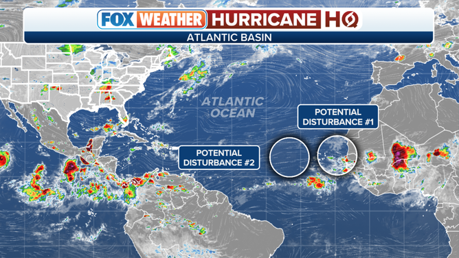
The National Hurricane Center is monitoring two areas in the Atlantic for possible development.
(FOX Weather)
There is no indication at this point that either potential system will turn into a threat, but we’ll watch to be sure. Nothing will happen fast, and the weather pattern closer to the Caribbean and the U.S. is generally hostile to tropical systems.
The National Hurricane Center gives both potential systems a low chance of developing over the next week.
There is still a lot of dry air over the eastern tropical Atlantic, which appears to be the main factor limiting potential development. The upper-level winds look reasonably conducive, and the ocean water is extra warm.
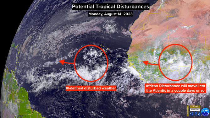
NOAA satellite view monitoring two areas in the Atlantic for possible development.
(FOX Weather)
In the middle of August, we watch this part of the ocean carefully, of course. Based on the data from past hurricane seasons, the odds of a system developing into a tropical storm or hurricane ramp up significantly beginning next week.
Looking at the big picture, the weather is finally behaving more like we expect in an El Niño year – when the equatorial Pacific south of Hawaii is extra warm. Storms have been developing right and left in the eastern Pacific, and hostile upper winds have been a regular feature in the Caribbean.
The forecasts from NOAA, Colorado State, and other agencies for the rest of the hurricane season favor a higher ratio of hurricanes to named storms than average. In other words, if a system gets named, it’s more like that average to turn into a hurricane and perhaps a Cat 3+ storm.
The thinking is, there is more energy than average in the ocean water, so storms have a higher peak-wind-speed potential. The odds in an El Niño year favor the most conducive conditions for development being over the distant tropical Atlantic because the upper-level winds are more likely to be hostile over our side of the ocean and the Caribbean.
That’s just odds and average conditions, however. It only takes one week of a conducive atmosphere for a hurricane to form and impact land. That’s what happened in 1992. The weather pattern was hostile through most of the hurricane season, with the notable exception of the third week of August when Hurricane Andrew formed and tore across South Florida.
Only 7 storms were named that year, 4 of which were hurricanes. The 3 hurricanes besides Andrew all stayed well offshore.
So we hope the odds work out, but we have to be ready in case the door opens for a storm to intensify and track to the west.