Bryan Norcross: Tropical Storm Philippe to track uncomfortably close to the Caribbean islands
Everybody from Puerto Rico to Guadeloupe and the surrounding islands needs to stay informed about Philippe's latest track and any watches and warnings that are issued.

FOX Weather is your Hurricane HQ, streaming free 24/7.
( / FOX Weather)
Updated Sunday at 9:30 a.m. EDT
The tropical two-step that Tropical Storm Philippe and Tropical Storm Rina were doing in the Atlantic east of the Caribbean will end today. Rina will end up the loser of the close-quarters competition that resulted in the storms doing a tropical twirl – rotating in a giant circle around each other.
Hostile upper winds, along with its close proximity to Philippe, has Rina on its last legs. The storm is forecast to lose its tropical identity today and be reduced to a remnant swirl.
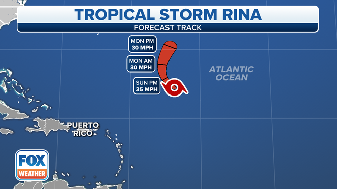
Tropical Storm Rina's forecast cone.
(FOX Weather)
Rina’s demise will allow a more typical steering pattern to reestablish itself in the region. High pressure to the east and a dip in the jet stream coming from the west will provide a pathway to the north for Philippe in the coming days. With Rina’s nagging hostile wind flow out of the way, Philippe is forecast to intensify into a hurricane later in the week.
The open question is the short-term track. How close is it going to come to the islands in the extreme northeast Caribbean as it begins its arc to the north. Everybody from Puerto Rico to Guadeloupe and the surrounding islands needs to stay informed about the latest track and any watches and warnings that are issued.
The good news is that Philippe is an unbalanced system with the strongest winds and heaviest rain on the opposite side of the circulation from the islands. If the center of circulation comes over or very near the northeast corner of the Caribbean, the islands would be impacted by the relatively weak side of the storm, as it appears now.
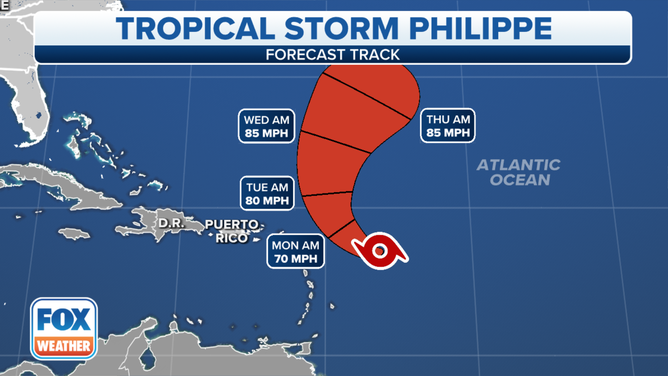
Tropical Storm Philippe's cone.
(FOX Weather)
However, since Philippe is forecast to be in an organizing stage when it's passing the islands, it’s not 100% that the stronger thunderstorms might not wrap around the storm about the time it’s near the islands. It will be a close call whether the National Hurricane Center thinks the threat will be sufficient to warrant issuing alerts.
A Tropical Storm Watch means that some winds over 40 mph are POSSIBLE in a given location, which is a pretty low bar. Stay on the lookout for the latest alerts. If Philippe behaves properly, it will bend north with just a light brush on the islands and be pulling away by Tuesday. But a slight track deviation could increase the likelihood and intensity of some gusty squalls on some of the islands.
Once Philippe is out of the picture early in the week, no tropical threats are evident. Normally, we'd be especially vigilant in Florida this time of year. The long-range computer forecast shows a generally hostile weather pattern over the Gulf, the Florida Peninsula and the surrounding area, however. If it holds, this pattern is more likely to drive a cold front south than to pull a hurricane north. We'll see.