Bryan Norcross: Tropical Storm Philippe forecast to strengthen – could come uncomfortably close to islands
When two storms come close to each other, especially if they are similar in size and intensity, the circulations interact in a way to cause the system to rotate around a nominal central point between in a counterclockwise way. It’s called the Fujiwara effect or a binary interaction.

FOX Weather is your Hurricane HQ, streaming free 24/7.
(FOX Weather)
Updated at 9:15 a.m. ET Saturday
Tropical Storm Philippe is the apparent winner of the two-storm dance-off that’s been playing out in the Atlantic just east of the Caribbean. In an unusual, but not unheard of, move, Tropical Storm Rina butted into Philippe’s oceanic space on Thursday at more-or-less equal intensity to a weakening storm ahead of it.
When two storms come close to each other, especially if they are similar in size and intensity, the circulations interact in a way to cause the system to rotate around a nominal central point between in a counterclockwise way. It’s called the Fujiwara effect or a binary interaction.
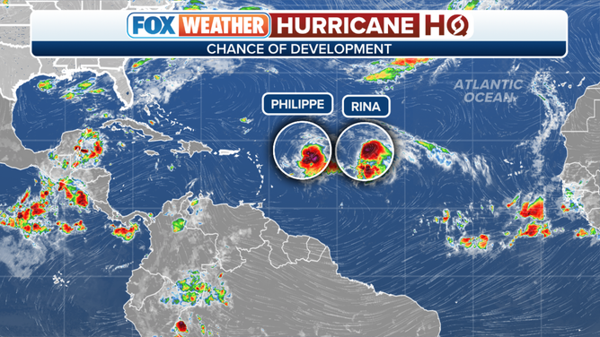
To the east of the Caribbean, a complex scenario is playing out across the Central Atlantic as two tropical storms(Philippe and Rina) are close enough to each other to interact and impact each other's eventual strengths and paths as they rotate around each other (Fujiwhara Effect).
(FOX Weather)
It’s rare that this merry-go-round of storms has a fairytale ending, however. Quite often, one storm ends up dominating the other. In this case, upper-level winds were stronger over Rina ripping the storm apart. As a result, Tropical Storm Rina appears destined to limp off stage right into the central Atlantic and die.
Philippe, on the other hand, has been just outside the band of storm-killing upper winds as it drifts south due to flow around faltering Rina.
There is a strong consensus that Philippe will move north of the islands and strengthen into a hurricane well away from land. What’s less certain is what’s going to happen in the short term.
The National Hurricane Center forecast calls for Philippe to drift around the Atlantic waters just northeast of the Caribbean islands over the weekend, then begin strengthening and pulling away to the north late tomorrow into Monday. If Philippe stays weaker longer, however, it could take longer to turn north.
Most of the computer forecasts show Philippe making its north turn comfortably to the east of the islands, but not all. There is still a possibility of a weak to moderate tropical storm affecting the northeastern Caribbean, perhaps as far west as the Virgin Islands. That appears to be the less-likely scenario, but the odds are sufficiently high that everybody in Puerto Rico and the surrounding islands needs to stay informed until it’s clear that Philippe has made its turn north.
The system will be moving slowly, so it’s not going to pounce. We should know by Monday if the coast is clear or not.
Otherwise, the is nothing obvious on the horizon, and the upper-air pattern across the tropics is turning more hostile to development. But the waters are still spectacularly warm, so if a system found a hospitable patch of atmosphere, it would have extra energy to work with. So we watch.