Bryan Norcross: Defiant Tropical Storm Philippe bringing flooding rain to some Caribbean islands
The complex and subtle atmospheric pattern about Philippe as brought the world’s most advanced computer forecast models to their knees. And the National Hurricane Center forecast, which is largely based on the consensus of the on-average best computer forecasts, has pointed all over the ocean as well.

FOX Weather is your Hurricane HQ, streaming free 24/7.
(FOX Weather)
Updated at 9 a.m. EDT Tuesday
Tropical Storm Philippe is like the middle son who will not under any circumstances do what he’s told to do. In fact, he does the opposite.
The complex and subtle atmospheric pattern about Philippe as brought the world’s most advanced computer forecast models to their knees. And the National Hurricane Center forecast, which is largely based on the consensus of the on-average best computer forecasts, has pointed all over the ocean as well.
Philippe has put the oft-stated-here rule of forecasting that predictions for disorganized, just-organizing, and slow-moving systems are subject to larger-than-average errors front and center.
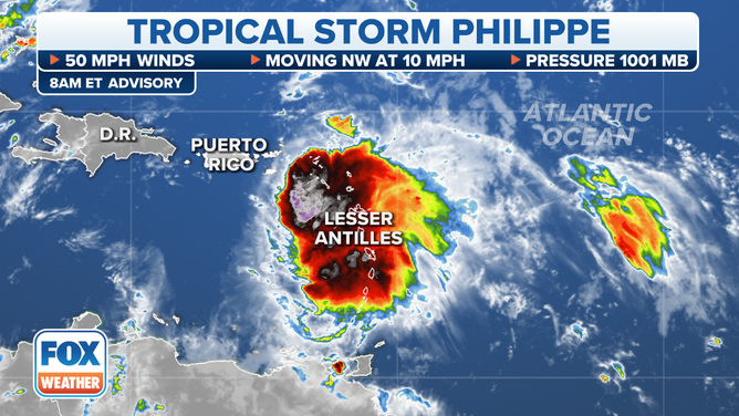
Tropical Storm Philippe's stats.
(FOX Weather)
This situation isn’t as consequential as 2015’s Hurricane Joaquin, which was forecast to move north toward the mid-Atlantic but went south and mauled the Central Bahamas. Or Dorian, which defiantly pounced on the Virgin Islands as a hurricane when it was forecast to threaten the Dominican Republic. But it’s been ugly.
The good news is, Philippe is not a super-strong storm. Although there is a mass of tropical thunderstorms on its south side, which it’s dragging over the northeastern Caribbean islands. Guadeloupe and Dominica have taken the brunt of the hit so far, and the flooding rain will continue there today as Philippe only slowly moves away to the north.
Even though the center of the circulation is between the British Virgin Islands and Anguilla, just about to move into the Atlantic waters north of the islands, the mass of tropical moisture, gusty squalls, and tropical downpours is still over the islands and the surrounding waters.
Philippe is not strong enough to wrap the moisture around its center of circulation as it pulls away, so tropical downpours are forecast to continue over the islands for at least a few more days, even as the storm’s center pulls away to the north. Soils are saturated on some islands, so flash flooding is possible. Stay aware of local alerts.
Looking ahead, Bermuda is now in the cone. The forecast atmospheric pattern has been stunningly inconsistent in that time frame as well, and now appears to be somewhat hostile to Philippe getting terribly strong. A high-end tropical storm is now forecast when the center of Philippe’s circulation is in the vicinity of the island about Friday.
Long-range computer models show Philippe strengthening after it passes Bermuda, becoming a formidable storm that threatens Atlantic Canada over the weekend. Although that forecast has changed many times as well.
Philippe is a testament to the immutable fact that the Earth’s atmosphere is a chaotic system, which means that occasionally weird, unforecastable things will happen. Modern forecasting techniques, higher-resolution atmospheric-data-collection systems, and scientific research have made the forecasts for most storms dramatically more accurate than they were just 20 years ago. But sometimes Mother Nature taps us on the shoulder and reminds us not to get cocky.
Nothing else appears to be brewing. A relatively hostile weather pattern is settling over the tropics for now.