Tropical Storm Earl tracks close to the Caribbean islands and a new disturbance to watch
Tropical Storm Earl is making its closest approach to Puerto Rico and the nearby northeastern Caribbean islands today. The National Hurricane Center predicts that Earl will eventually become a hurricane over the open ocean. Well to the north, Hurricane Danielle is drifting around, trapped by a blocking high-pressure system. A new tropical disturbance just moved off the coast of Africa.
The podcast Tracking the Tropics with Bryan Norcross is now available to stream.
(FOX Weather)
Updated at 9:10 a.m. EDT
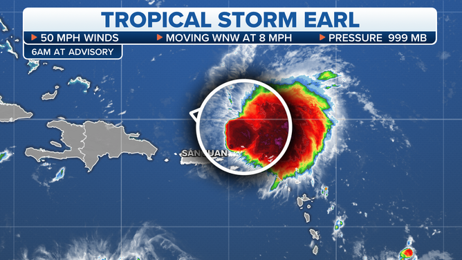
Tropical Storm Earl is making its closest approach to Puerto Rico and the nearby northeastern Caribbean islands today. The strongest winds will stay offshore, but bands of gusty tropical downpours will pass over the islands as they rotate into Earl’s circulation.
The hostile upper-level winds let up enough for thunderstorms to form near the center of Tropical Storm Earl yesterday, which allowed the system to put on a strengthening spurt. Normally a stronger storm in the vicinity of land areas is a bad thing, but you can make a case that it’s the opposite in this situation.
Tracking Tropical Storm Earl
(FOX Weather)
A more intense storm is taller in the atmosphere, which means it is steered by higher-level winds, which tend to be stronger. In the case of Earl, this means the system should begin its move away from the islands later today or early tomorrow. The concern was that Earl might remain a weak disturbance, which could have left it drifting in the waters north of Puerto Rico and east of the Bahamas in an area of weak steering.
The original disturbance and now Tropical Storm Earl has been driven toward the islands by a blocking high-pressure system to the north. But now, a combination of Hurricane Danielle and a strong dip in the jet stream moving off the East Coast of the U.S. will open a gap in the high and pull Earl to the north.
The upper-level winds are still somewhat hostile, which should keep Earl relatively weak while it’s in the vicinity of the islands. But once it’s moving north, the environment is expected to become conducive to Earl getting stronger. The National Hurricane Center predicts that Earl will eventually become a hurricane over the open ocean.
Some computer forecast model projections show Earl becoming quite strong in a few days. Bermuda will have to keep an eye on the system later in the week.
The only current threat is bands of heavy rain causing flooding and mudslides on some islands in the northeast Caribbean.
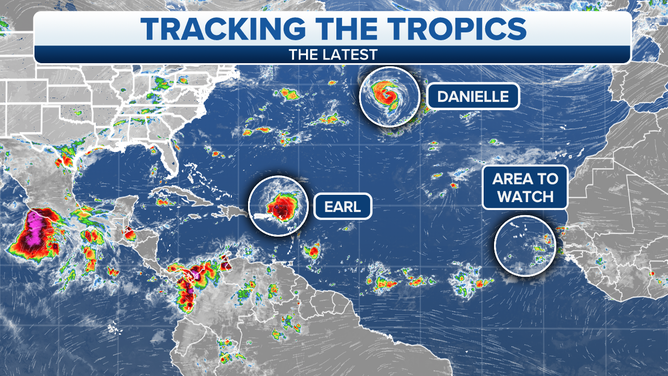
Latest Tracking the Tropics as of September 4, 2022.
(FOX Weather)
Well to the north, Hurricane Danielle is drifting around, trapped by a blocking high-pressure system. It will slowly begin moving in the next couple of days and be captured by the northern jet stream. Its remnants could affect the British Isles.
A new tropical disturbance just moved off the coast of Africa. In a few days, it might develop into at least a tropical depression, though the National Hurricane Center is giving it a low chance at this point. The early forecast is for it to move into the central Atlantic and not be a threat to land.
Otherwise, nothing appears to be in the offing across the tropics. The unusual hurricane season continues.
FOX Weather Hurricane Specialist Bryan Norcross has a podcast, Tracking the Tropics with Bryan Norcross, available now on FOX News Audio. You can get it on your device by clicking here.