Bryan Norcross: An old disturbance is back – near the Carolina coast but moving offshore
The steering flow near the East Coast of the U.S. is moving fast, so the Tropical Disturbance will leap ahead of the disturbance in the central Atlantic called Invest 96L as they both head into the North-Atlantic tropical graveyard.

FOX Weather is your Hurricane HQ, streaming free 24/7.
(FOX Weather / FOX Weather)
UPDATED Sunday at 9:40 a.m.
The Tropical Disturbance just off the North Carolina coast is the same system that dumped buckets of rain on South Florida last Thursday. It trekked up the east coast of Florida and plagued the Carolinas for the last two days.
Now the disturbance is heading off into the Atlantic. As it tracks over the warm Gulf Stream over the next couple of days, it will have a chance to develop into a tropical depression or tropical storm. It should get absorbed by a frontal system by midweek, and its story will end.
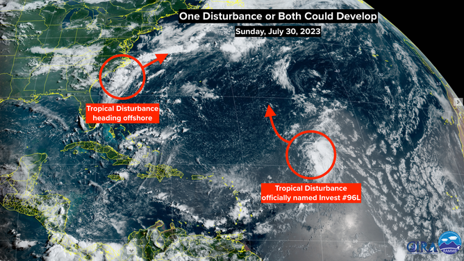
NOAA Satellite image shows two disturbances in the Atlantic Ocean.
The steering flow near the East Coast of the U.S. is moving fast, so the Tropical Disturbance will leap ahead of the disturbance in the central Atlantic called Invest 96L as they both head into the North-Atlantic tropical graveyard.
The central-Atlantic disturbance, Invest 96L, is finally moving out of the mass of Saharan dust it has been trying to fight off since it rolled off Africa. Over the next few days, this system has a good chance of developing into a tropical depression or storm before it reaches the cold water of the North Atlantic.
Neither system is a threat to land. If the National Hurricane Center determines that the top sustained winds in either or both systems are 40 mph or higher, they will use the names Emily and Franklin. It’s a bit of a race to see which one gets named first if they get names at all.
Saharan dust is blanketing the tropical ocean, which is squashing African systems with dry air. The long-range computer forecasts show the dust continuing to dominate over at least the next week. So it looks like August will start quietly.